All Activity
- Past hour
-
9:15 I think...but yeah could be a traffic nightmare
-
Hangin in and hangin on.... The weather and cooko for cocco puff light and sound show last night, coupled w/ the monsoonal rains, scared my arse right outta my cave....so here i am. hell...i'll say it.....UNCLE! What a diff a year makes. Not sure which evil is better, but like my wife always says, too much is better than not enough, so I'll go w/ that, and see how tonight goes. Hope you are doing well/better. and hope the rest of you blokes are well also.
-
91/75
-
9pm is the nyc fireworks? My plane lands at jfk on the 4th at like 815. Im wondering if I hit monster traffic leaving jfk to head back to nj.
-
Conestoga River is now over flood stage at Lancaster.
-

July 2025 Obs/Disco ... possible historic month for heat
powderfreak replied to Typhoon Tip's topic in New England
Is that when you went on a Jebwalk around the neighborhood and your wife went looking for you, thinking you were dead in a snowbank? -
July 2025 Obs/Disco ... possible historic month for heat
powderfreak replied to Typhoon Tip's topic in New England
Wholesale change time. Beslow’s computer model is like the GFS. Cora has run his course. Let the young guys play. -
Nice work pal. Enjoyed the read. Thanks for the insight.
-
 85/77
85/77 -
I'm sitting at 30.88" YTD - you have; however, doubled my rainfall total since Saturday that really narrowed the gap. I really "cleaned up" during May. Good to hear from you during your hibernation. A lot of us are certainly at the point of crying "uncle". Of course, we'll probably flip a switch and enter a prolonged dry spell over the 2nd half of summer. It would be nice if we could ration all of this out, ya know?
-
I like your sense of humor. We would probably have a really good time if we had one of the forum get-togethers. My buddies and I were all pretty big practical jokers back in the school days. The patterns over the last decade have really been a teachable moment for all of us. While the climate models have the general idea about warming over time correct, the regional nuisances have been pretty far from what the expectations were. This new subtropical ridging and rapid SST warming in the mid-latitudes wasn’t expected. The old batch of climate models had the strongest ridging and SST warming further north near the subarctic regions. So it’s a bit like running a big science experiment and finding out which ideas were correct and which ones missed the mark. This new -PDO era in the 2020s is more defined by the warmer WPAC than a cooler EPAC. I think this is why we have been seeing more variability between -PNA intervals and +PNA periods. So we get these quick month to month change ups especially out West. But unfortunately we have still been getting strong Southeast Ridges and Western Atlantic Ridges under both PNA phases.
-
The NAM forecast soundings are not pretty 2:00 PM (Second Image) Thermodynamics: Moisture has deepened significantly through the low-mid troposphere. CAPE increasing. Inversion breaking down. CIN: Nearly eliminated. Wind: Weak veering. Still light but flow is organizing. Interpretation: This is the convective initiation (CI) window. Expect first storms around or after this point, especially if boundaries are present. Tall, narrow CAPE profile supports efficient rainfall. --- [emoji419] 5:00 PM (Third Image) Thermodynamics: CAPE is strong, with tall and narrow shape: classic flash flood profile. Fully saturated up to ~500 mb. Wind: Still weak steering, slight veering. Winds supportive of parallel cell orientation, a key factor in training/banding. Interpretation: This is the high risk time for backbuilding storms. Low LCLs + tall moist layer = efficient rain production. Very favorable for anchored convection with heavy rain. --- [emoji419] 8:00 PM (Bottom Image) Thermodynamics: CAPE remains robust. Deep warm-cloud layer (melting level) = high rainfall efficiency. Winds: Very weak aloft → poor storm motion → cells likely to stall. Shear drops significantly. Interpretation: Flash flood risk peaks if convection sustains. Weak outflow winds suggest training, merging cores, or cell regeneration. Sent from my SM-G970U1 using Tapatalk
-

Central PA Summer 2025
Mount Joy Snowman replied to Voyager's topic in Upstate New York/Pennsylvania
Yes, I'm hoping that's our saving grace today, that the cold front rams things right on through. The lack of steering winds yesterday was a big part of the problem. Still, we can't afford much out our way without big issues arising quickly. I'm in Harrisburg today so maybe I brought the storms with me up this way. -
while thats often the case, we are waterlogged down here and runoff is largely cause soil cant hold anymore. NWS suggested that in their recent disco for today's possible "fun". I passed 3 stranded cars on way to work, and 2 were in pretty deep (etown rd and near my home in akron). Good luck to all who got hammered yesterday and may get it again today. that graph above is ominous for us southers.
-
 Olilon00 joined the community
 -

July 2025 Obs/Disco ... possible historic month for heat
Damage In Tolland replied to Typhoon Tip's topic in New England
Getting sun now . I’m sure it won’t matter as Steinfeld takes care of things -
 egg laid brain joined the community
 -

July 2025 Obs/Disco ... possible historic month for heat
CoastalWx replied to Typhoon Tip's topic in New England
I know I've said this before, but that was just cutting down the snow banks. I know it looks angry.....but do you honestly think there was any anger there in that situation? LOL. -
 Bright blue skies up here in Mahwah, 81 degrees.
 -
The usual Allegheny County flash flood warning in effect. Flash Flood Warning PAC003-125-011745- /O.NEW.KPBZ.FF.W.0095.250701T1451Z-250701T1745Z/ /00000.0.ER.000000T0000Z.000000T0000Z.000000T0000Z.OO/ BULLETIN - EAS ACTIVATION REQUESTED Flash Flood Warning National Weather Service Pittsburgh PA 1051 AM EDT Tue Jul 1 2025 The National Weather Service in Pittsburgh has issued a * Flash Flood Warning for... Central Allegheny County in southwestern Pennsylvania... Central Washington County in southwestern Pennsylvania... * Until 145 PM EDT. * At 1051 AM EDT, Doppler radar indicated thunderstorms producing heavy rain over Wilkinsburg, or near Penn Hills, moving east at 20 mph. Between 0.5 and 1 inch of rain has fallen. Additional rainfall amounts up to 1 inch are possible in the warned area. Flash flooding is ongoing or expected to begin shortly. HAZARD...Flash flooding caused by thunderstorms. SOURCE...Radar indicated. IMPACT...Flash flooding of small creeks and streams, urban areas, highways, streets and underpasses as well as other poor drainage and low-lying areas. * Some locations that will experience flash flooding include... Pittsburgh, Penn Hills, Mount Lebanon, Bethel Park, Ross Township, McCandless Township, Monroeville, McMurray, McKeesport, Canonsburg, Gastonville, Shaler Township, Plum, West Mifflin, North Side Pittsburgh, Baldwin, Upper St. Clair, Hampton Township, Scott Township and Wilkinsburg. PRECAUTIONARY/PREPAREDNESS ACTIONS... Turn around, don`t drown when encountering flooded roads. Most flood deaths occur in vehicles. && LAT...LON 4023 8027 4039 8026 4057 8000 4058 7977 4055 7977 4055 7974 4053 7971 4039 7975 4039 7976 4037 7977 4030 7979 4029 7978 4028 7980 4026 7979 4024 7981 4023 7980 FLASH FLOOD...RADAR INDICATED $$ MLB
-

July 2025 Obs/Disco ... possible historic month for heat
HoarfrostHubb replied to Typhoon Tip's topic in New England
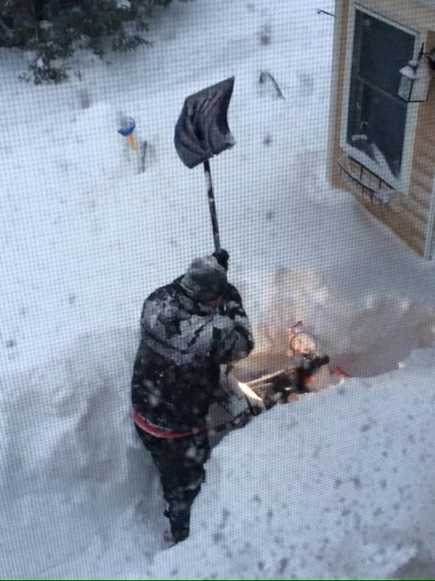
It’s one of my favorite snow related pictures ever. From one of the best winters ever. -
July 2025 Obs/Disco ... possible historic month for heat
CoastalWx replied to Typhoon Tip's topic in New England
Those were the days. I think back to that year a lot. Three winter seasons of complete angst and hopelessness has finally got me. I'm broken and as someone who used to love winter...it's not the same feeling anymore. -
July 2025 Obs/Disco ... possible historic month for heat
CoastalWx replied to Typhoon Tip's topic in New England
LOL how do you still have that? -
welcome to the swamps of dagobah!
-
Well this sounds exciting. The combination of appreciable instability and highly anomalous PWAT values will make storms today capable of producing very high instantaneous rainfall rates.
-
 It’s is incredibly muggy out there. Dew is 75
 -
July 2025 Obs/Disco ... possible historic month for heat
HoarfrostHubb replied to Typhoon Tip's topic in New England
You angered Ullr