All Activity
- Past hour
-
This says it all in the afternon update:
-
Scoots by both our subs to the North on its way to hit New England.
-
Maybe it pops a late coastal after 120 but idk. It is tilting but just not a clean enough deal. Oh well. On to the GFS (which I won't handle...)
-

Central PA Winter 25/26 Discussion and Obs
Itstrainingtime replied to MAG5035's topic in Upstate New York/Pennsylvania
WTF? -
Pretty close by 144. Close enough that its on the same playing field still. This run an ass hair delayed in developing, just slower imo.
-
An orderly pattern progression remains underway. The warm anomalies peaked yesterday with temperatures running 12.6° above normal in Central Park. In the extended range, that progression should culminate in a return to colder weather with persistently below normal temperatures. Rain and showers will end early tomorrow. Rainfall remains on track for a storm-total 0.50"-1.00" rainfall across much of the region by the time the last showers depart early tomorrow. Through the middle of next week, highs will generally reach the 40s during the daytime and 30s for lows in New York City. Somewhat colder readings are likely outside the City and in areas where strong radiational cooling takes place. After the middle of next week, temperatures will "step down" with highs mainly in the middle and upper 30s in New York City and lows in the middle and upper 20s. Some light precipitation is possible on Friday. No significant Arctic blasts or significant snowfalls are likely through at least mid-January. Afterward, conditions might become more favorable for both cold and snowfall, especially if the PNA goes positive. PNA-related developments would have larger implications for snowfall. A persistently positive PNA would have above climatological risk of moderate or significant snowfalls. A mainly negative PNA would favor mainly small snowfalls. It will likely be another day or two before the guidance reaches the high-skill timeframe for teleconnection forecasts. The ENSO Region 1+2 anomaly was -0.7°C and the Region 3.4 anomaly was -0.5°C for the week centered around December 31. For the past six weeks, the ENSO Region 1+2 anomaly has averaged -0.37°C and the ENSO Region 3.4 anomaly has averaged -0.63°C. La Niña conditions will likely continue into at least late winter. The SOI was +21.91 today. The preliminary Arctic Oscillation (AO) was -2.082 today. Based on sensitivity analysis applied to the latest guidance, there is an implied near 58% probability that New York City will have a cooler than normal January (1991-2020 normal). January will likely finish with a mean temperature near 33.3° (-0.4° below normal). Supplemental Information: The projected mean would be 0.7° above the 1981-2010 normal monthly value.
-
Yeah by 108 you can see how the low is not diving in and cutting off in Tennessee, but instead Indiana/Ohio.
-
Haha. You all know I am not using chatGPT, because there are so many auto-correct spelling errors or careless errors. If those aren't present, I have been sucked into the singularity and there needs to be a well check.
-
If I recall correctly the AIEuro was better than just about every other model regarding snow last winter. The GEM was usually too extreme.
-
By 96 it might still have a chance. Heights behind it are very strong, might be able to make up for the pieces starting further apart. But I still think it won't quite get there.
-
The Euro deterministic didn't look terrible. Indeed, its ensemble is much different than other ensembles, BUT has trended towards the other cluster of ensembles (eastern intrusion of BN heights after the 20th) since yesterday. That tells me the EPS is probably still correcting. FWIW, the EPO ridge appears to have some staying power. I think the spacing and timing of the next three windows is incredibly important - 15th, 17th, and 20th. Amplified troughs will often over perform IMHO.
-
Not sure I like the ICON at 78hrs. Northern and southern streams appear further apart. PV nudged west and closer to the northern stream piece and may serve to squash things later down the line. We'll see.
-
That CPC had no heavy snowfall threats on its 3-7 day hazards outlook suggestes that the CPC also believes the latter system poses a greater winter weather risk.
-

January 2026 regional war/obs/disco thread
brooklynwx99 replied to Baroclinic Zone's topic in New England
absolutely, allows that NS piece over the Lakes to come in at a good angle... that's why the GFS is as amped as it is -

January 2026 regional war/obs/disco thread
Typhoon Tip replied to Baroclinic Zone's topic in New England
Also useful to point out that the bulging into Manitoba is really critical there. That axial location near Frisco is traditionally too far west, but the idiosyncrasy of that arm rotating S on the heals of the 'Lakes trough is completing the wave space's couplet ...which transitively is favorable for maintaining amplitude that far E of the "real" ridge axis. Synoptic interpretation is a lot harder than folks realize. Just seeing where ridges and troughs are isn't the half of it. -
Selfishly, I'm more interested in the one closest in time currently. There looks to be a lot of energy with that system and a decent shot to overperform for someone from the east TN/southern apps part of our region. What catches my eye about this one is the GFS (normally our progressive model) is the one that closes off at 500, slowing the flow and popping a lee side low, while the Euro briefly closes off in the Ohio Valley, but quickly opens back up and scoots harmlessly out to sea. The initial system aside, I think the follower has the potential to be a big system. If you cycle through 500, the piece of energy around day 6 as shown on the 12z GFS comes in much further west through western Montana. Interestingly, even though at the surface it was a smoke show for the entire midsouth, it could have been even bigger if the piece from the four corners had gotten out in front of the energy diving south through the Dakotas (shown above) allowing for a phase. It's this piece in the four corners that detaches from the flow that @Carvers Gap notes as something to watch around the 20-21st. The Euro is much different in the evolution regarding the follower. Lots will change in the next couple of days, but even the Euro while saying no shows quite a bit of "potential".
-
Hopefully the Euro is wrong,its still showing the MJO in the WP and with some strong blocking into Siberia but its shows a Asian winter time monsoonal flow,rhis would be a waste with the blocking into Siberia it shows in our parts
.png.d8b785a36a14e09b2925943305947b48.png)
-
It might be better to have this thread as a period of interest between the 15th and the 18th
-
Currently: Light rain. 34.5°
-

Central PA Winter 25/26 Discussion and Obs
pasnownut replied to MAG5035's topic in Upstate New York/Pennsylvania
?? Whats the 26th? -

January 2026 regional war/obs/disco thread
tamarack replied to Baroclinic Zone's topic in New England
7/3/66 takes (bakes?) the cake. The coil thermometer at the end of the counter, 10-12 feet from the grill, reached about 140 - scale only reached 120 and the needle was well beyond that line. I'm better off NOT knowing how hot it next to the grill. In 1977 I could climb down to the 1st floor in 20 seconds. In 1966 I was behind the counter all day. Closing time was 8 PM but people were still pouring in 15 minutes later, so I went on the loudspeaker to say we were closed but would serve all who were already inside the lodge. (Got a bit of flack from the park supervisor but he soon understood.) At that time, I'd never had a cup of hot coffee despite brewing the stuff in the 50-cup urn. Ice tea demand went up and down with the temp; coffee demand went up and down by how many people came thru the gate. Could not understand then but later learned the joy of hot coffee in all weather. -
January 2026 regional war/obs/disco thread
brooklynwx99 replied to Baroclinic Zone's topic in New England
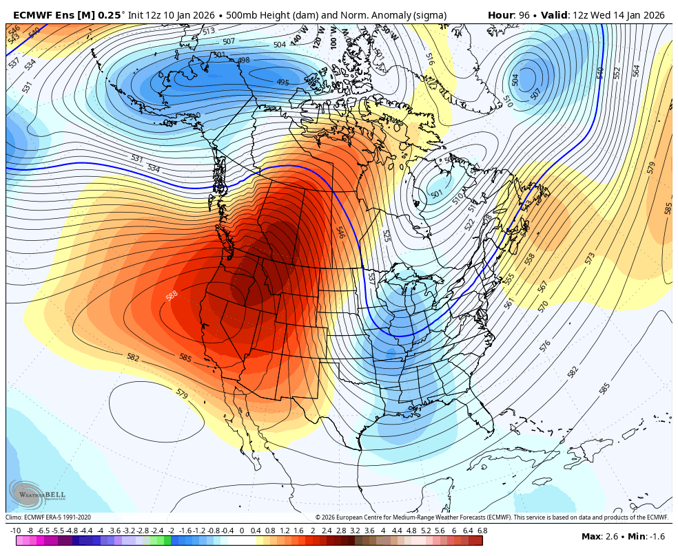
the +PNA ridge in and of itself argues for a coastal... that's 2.5 sigma over ID, nearly ideal
-

Central PA Winter 25/26 Discussion and Obs
Ruin replied to MAG5035's topic in Upstate New York/Pennsylvania
the 26th? lol um yeah book mark this watch it be like 50 and sunny lol. -
1.15" so far. A soaker.
-

January 2026 regional war/obs/disco thread
weathafella replied to Baroclinic Zone's topic in New England
More than slightly. 40s for you are +10 for a high. But certainly well below January thaw levels which when I conjure in my mind I think 55+