All Activity
- Past hour
-
I'm sure it will dry out again come June, wet summers are rare here without tropical involvement.
-
You can get there that quick? Takes me 4 hours to get to Stow.
-
But aren't we supposed to have stronger SE ridges too? Those generally establish a ring of fire that keeps the storminess to our north and west.
-
The good thing is all these things will put a check on human overpopulation in a big way. Nature always knows best.
-
So, earlier, NWS Mount Holly dropped maps on X showing amounts up to 3" over North Jersey. I replied with my skepticism, similar to what I did here. And their account replied to me with the following: "We have been missing out on better rainfall recently, but chances are looking better for a soaking rain tonight and tomorrow, at least from around I-95 and northwest".
-

2025 Atlantic Hurricane Season
LongBeachSurfFreak replied to BarryStantonGBP's topic in Tropical Headquarters
I’m super biased because I’m an east coast surfer and we get our best waves as a result of tropical activity. But I think your right. The peak of last season illustrates that perfectly. Water temps will likely support another hyperactive season, but it’s one piece of the puzzle. Let’s see where ITCZ sets up as we head into June. -
This helps a lot.... The google searches of "stein weather" "what is stein weather" "New England stein weather" were not as helpful....
-
The roller coaster precipitation pattern. Either excessive rainfall or complete lack of. As the jet tends toward stagnant configurations. Fits the climate change forecasts and should only intensify.
-
So umm.... how much of Saturday is ruined? Frustrating differences in guidance.
-
I'm skeptical of upton's 70-90% chance of rain at least through tonight
-
Possibly nowhere for some. It all depends on where the storms pop up and any banding might set up. These are tricky forecasts and modeling hasn't been great. I'd be skeptical of calls for area-wide 2" the next couple of days, but that's just my non-expert opinion. Storms are firing off in their favorite spots out to the N and W. For now that's where they'll stay - they could sneak a little further into the area later on. We'll see.
-
I miss the old train stuff they had on display years back. Now they have one decomposing boxcar
-
There is a Boston area met on various media outlets that is obsessed with droughts... When there is any hint of dryness, we are in Stein mode...
-

E PA/NJ/DE Spring 2025 Obs/Discussion
RedSky replied to PhiEaglesfan712's topic in Philadelphia Region
Guidance has cut back on shower activity expected totals to .50" amounts through Friday, shocking I know -
72 and partly cloudy here for now
- Today
-
71° - A+ day
-
Downpours already popping in CT. Wtf
-
Frost advisory for most of southern MI tonight. With the summer-like warmth next week, even though not long-lasting, this should be the last frost until late September or early October.
-
This all supports my reasoning for eventually leaving VT from roughly March 15 through the end of May.
-
Good memory! Record low of 46F at DTW on July 2, 2001.
-

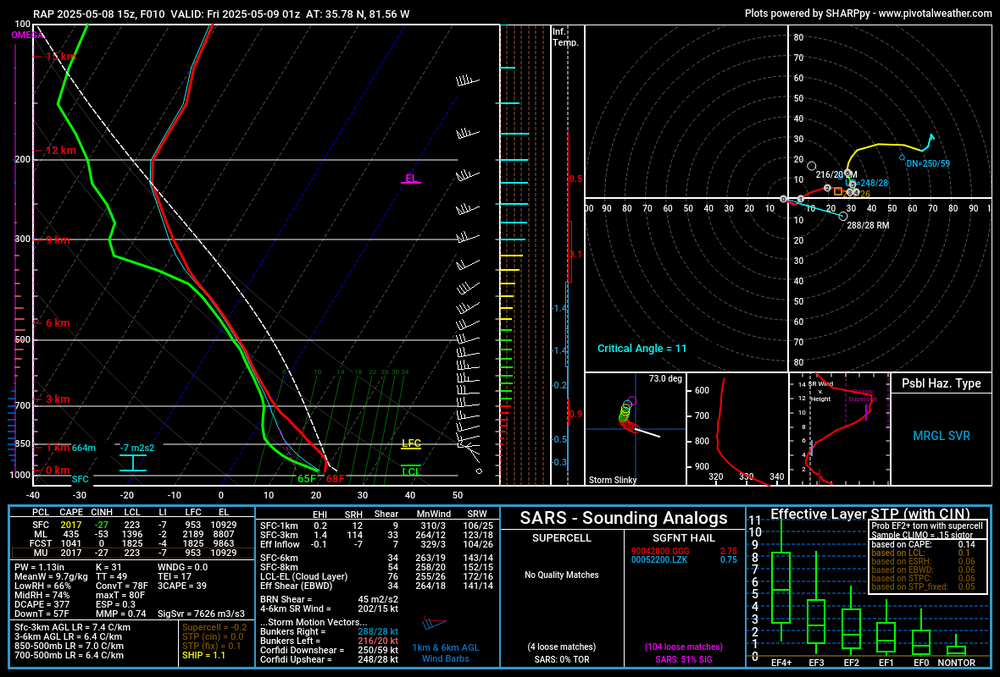
2025 Spring/Summer Mountain Thread
SUNYGRAD replied to Maggie Valley Steve's topic in Southeastern States
-
2025 Spring/Summer Mountain Thread
SUNYGRAD replied to Maggie Valley Steve's topic in Southeastern States
-
And it may not.
-

2025 Atlantic Hurricane Season
BarryStantonGBP replied to BarryStantonGBP's topic in Tropical Headquarters
LMAO at the cope. And LMAO at the warm neutral copers. Have you even checked out Gary Lezak's forecast Many models and mainstream forecasters have been busting hard -
2025 Atlantic Hurricane Season
BarryStantonGBP replied to BarryStantonGBP's topic in Tropical Headquarters
Models are busting hard, so I'm not even paying attention.