All Activity
- Past hour
-
Continuation of the summer theme. Same winners and losers over and over again.
-

2026-2027 Super El Nino
snowman19 replied to Stormchaserchuck1's topic in Weather Forecasting and Discussion
We are breaking a bunch of 1997’s records. We are on the verge of easily surpassing 1997’s subsurface warmth. The OHC has broken 1997’s record, which was +2.5C, we are at +2.8C, this ongoing WWB is record-breaking, much stronger than the one that occurred around the same time in 1997, the associated DWKW is also stronger. This -SOI run is breaking 1997’s record. We are warmer in both region 3.4 and region 3 and we are virtually neck and neck in region 1+2: WWB: Region 3 is forecasted to go off the charts: The 30C isotherm is further east than 1997 (east of the dateline) and still going: “2026 for the win! Part of the present advantage is the ongoing westerly wind burst timed later than the corresponding one in 1997 (which was late May/early June). This year's summer wind event was longer and ultimately stronger. The 30C isotherm east of the dateline continues to support the extreme potential for this event.” -
it’s tentative but we may be seeing a spring 2023-like global thermal surge beginning. Air and sea presently lurching in tandem.
-
Hopefully Lake Ontario with be bath water when the some strong arctic airmass flows over it. A wicket LES band with insane rates along with snownados (happens) hitting the Upper Tug would make my day.
-
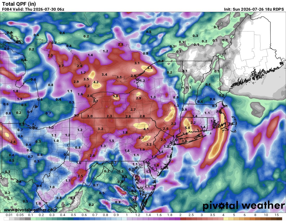
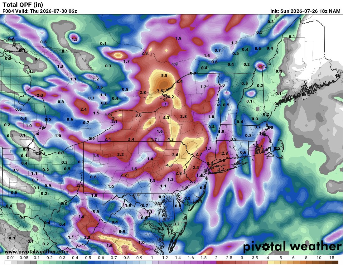
 The models seem overly sensitive/bad physics somehow in these feathery weak gradients/higher thickness synopsis. I mean look at the NAM. All protestations aside … still, it takes a thunderstorm complex over Milwaukee, turns it in a small low then counties evolve it from these spontaneous looking origins as it carries it to the Del Marva … where uses it to generate -2 relative to season SD 990mb coastal gale … I guess I dunno part of me just wonders if we’re getting a reality check fake out when we’re on top of the thing … something less “engineered” By the way … it’s tentative but we may be seeing a spring 2023-like global thermal surge. Air and sea presently lurching … we’ll see
 -
 Yep that be you.
 -
Burlington is 92/85/120 Ames is 92/86/123 This is as high as the dew point ever gets around here. It's only 83 here.
-
Dewpoint mixed out into the mid 60s so we had easy today even with a high of 98.
-
Not for nothing but weren't you the fella who called for a half inch during the last gully washer?
-
.thumb.gif.f92b16c631a1d15d405ed77b33f0710d.gif) Some will get 1-3", some will get more, some will get less (Stein). That's not a difficult forecast
Some will get 1-3", some will get more, some will get less (Stein). That's not a difficult forecast -

2026 Spring/Summer Mountain Thread
Maggie Valley Steve replied to Buckethead's topic in Southeastern States
The SW Mountains and NE Georgia might want to keep eye out for overnight thunderstorms moving in.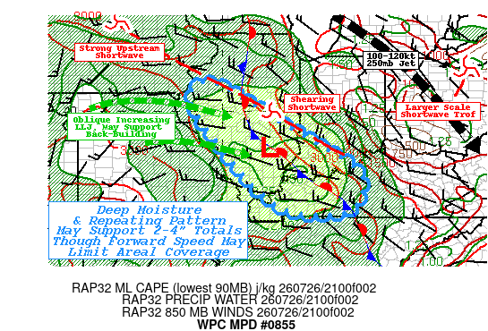
-
 I think there’s pretty good potential for a good 1-3” over a widespread area. Someone will get much more where it pivots. You have instability working in over high theta e converging on a warm front.
 -
 The whole thing went from SNE Jack to mainly NY state . You haven’t been looking daily while on vaca . We will get some rain obviously but wagons west for 1-5”+ etc .Pretty evident today
 -
People still drinking in here
-

2026-2027 Super El Nino
Stormchaserchuck1 replied to Stormchaserchuck1's topic in Weather Forecasting and Discussion
Everyone was saying 1998-2025 SOI was such that it is probably biased positive now. This is about as respectable as a downward drop as you will see. Here's the last 2 days.. 90-day and 30-day are both below -20 now. 26 Jul 2026 1011.41 1015.60 -31.64 -25.66 -20.20 25 Jul 2026 1011.59 1015.45 -29.61 -25.54 -20.06 This is turning into a top-5 -SOI event since the 1800s, so yeah it's probably not biased positive with AGW. - Today
-
It's an interesting coincidence. There's really no close comparison. I also doubt that the coming winter will be a close comparison.
-
Really liking to see this -SLP 60-90N pattern for the whole Summer so far. Since 2012 that has reversed to Winter AO almost everytime. -AO with Nino STJ could be the fuel to give us big snow chances. However, without a monster low in the N. Pacific it may be more about timing and "threading the needle".
-
Yes, that's true.
-
Tomorrow will be fair and warm. A storm will bring rain and possible thunderstorms to the region during Tuesday and Wednesday. The potential exists for a general 1.00"-3.00" rainfall with some locally higher amounts. Following the storm, Thursday and Friday will see a continuation of below normal readings. The ENSO Region 1+2 anomaly was +3.6°C and the Region 3.4 anomaly was +2.1°C for the week centered around July 15. For the past six weeks, the ENSO Region 1+2 anomaly has averaged +3.20°C and the ENSO Region 3.4 anomaly has averaged +1.82°C. The ongoing strong El Niño will continue to strengthen through the summer. The SOI was -31.64 today. The preliminary Arctic Oscillation (AO) was +1.391 today. Based on sensitivity analysis applied to the latest guidance, there is an implied near 92% probability that New York City will have a cooler than normal July (1991-2020 normal). July will likely finish with a mean temperature near 76.3° (1.2° below normal). Supplemental Information: The projected mean would be 0.2° below the 1981-2010 normal monthly value.
-
2026-2027 Super El Nino
Stormchaserchuck1 replied to Stormchaserchuck1's topic in Weather Forecasting and Discussion
I'm impressed at how much further west the subsurface warm pool extends vs 1997. This could mean two things: 1) There is more fuel for this Nino to go stronger - and perhaps stronger in Nino 3 2) The "Strong La Nina snap-back" for 27-28 may not be as probable as some may think. -
Yeah you have to wonder if it ends up mostly dry for some..time will tell
-
Spc has McD out for counties in south ky and also Clarksville and Robertson counties in tn watch probabilities 80% .
-
I thought that was just December...
-
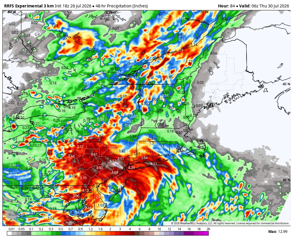
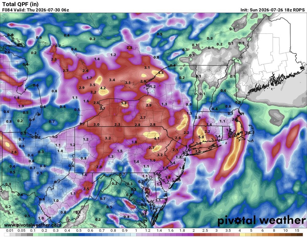
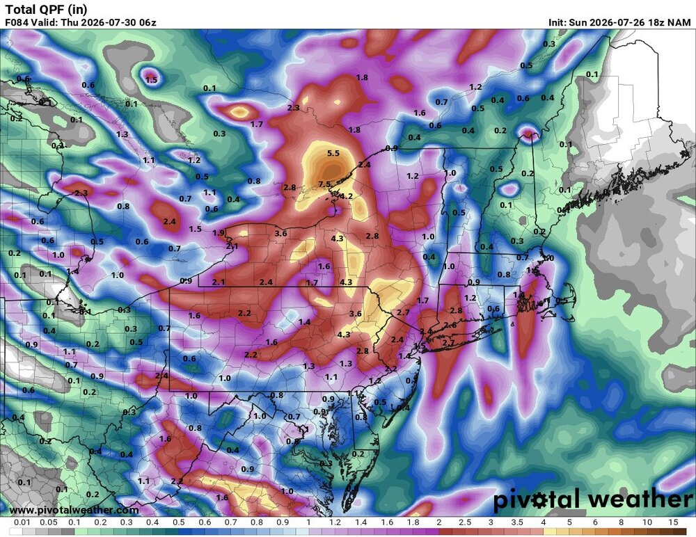
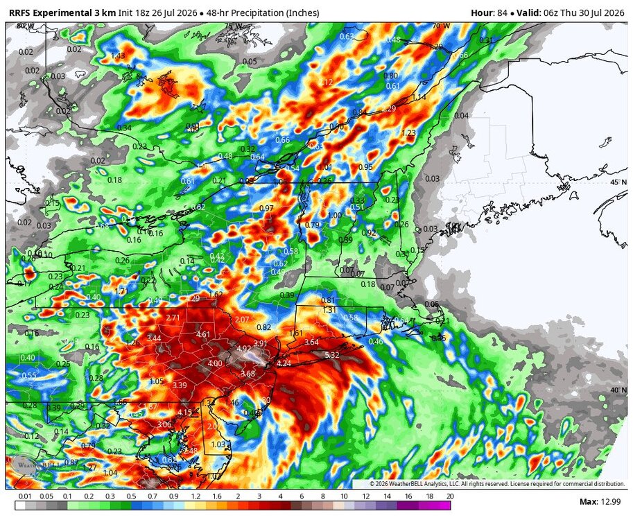
RRFS follows same theme
-
Starting pitching has been better than not bad than the last two months. I mean in July alone their ERA is first in the majors, and they have been fantastic since late May. Something to build on next year, imo Elias gotta go--our hitting woes and just being unclutch with poor fundamentals goes back to his system, imo Fundamentals especially were problem when Alby got here and the players all brought it to him...which means it runs deeper. I don't think anything gets better until they make the change. If they don't we could be sitting right here having the same convo next season (whenever it starts anyway, lol)