All Activity
- Past hour
-
Overall, it's looking like we'll at least have a normal winter in general. Something we really haven't seen in several years. At least in Southern New England.
-

September 2025 OBS-Discussion centered NYC subforum
LibertyBell replied to wdrag's topic in New York City Metro
deep blue skies are the best!! tomorrow won't be as good with high clouds coming in early -
September 2025 OBS-Discussion centered NYC subforum
LibertyBell replied to wdrag's topic in New York City Metro
High clouds coming in tomorrow morning so it won't be as nice as it is today. I noticed that SST have already started dropping and are in the mid to upper 60s now, even along the Jersey shore? -
September 2025 OBS-Discussion centered NYC subforum
LibertyBell replied to wdrag's topic in New York City Metro
The funny thing is NYC and LGA bringing up the rear in temperatures. NYC seems to have the lowest temperatures no matter the wind direction lol. -
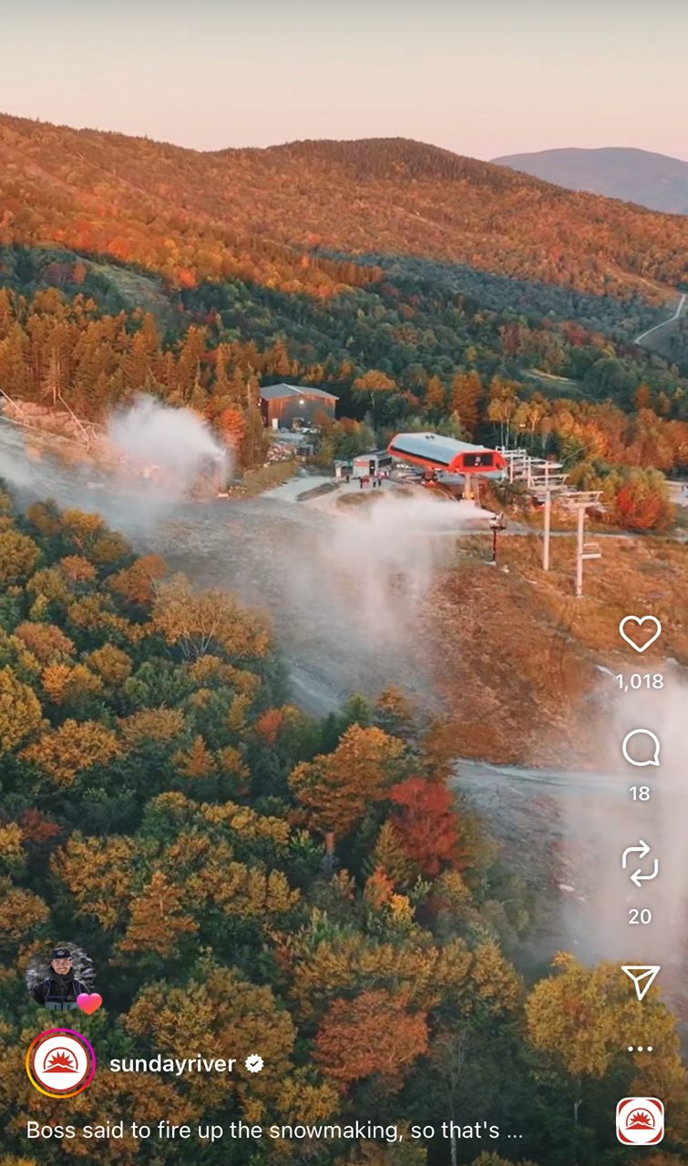
"Early Corner" in New Sharon, along US Rt 2 about 1/2 mile west from the Sandy River bridge. The soil there is somewhat poorly drained, almost a forested wetland, which causes the early change. It's about a week earlier than average, probably due to drought, though the 5 mornings in the 30s last week might've helped. This morning's 30 and tomorrow's frost/freeze will push the changes along, though there's an abnormal amount of leaf drop already, in that area and all over, especially ash, birch and red maple.
-

2025-2026 ENSO
PhiEaglesfan712 replied to 40/70 Benchmark's topic in Weather Forecasting and Discussion
Three of those years rank among the 11 hyperactive (180+ ACE) seasons, with 2 of the Top 3 overall: 1 2005 247.65 3 1893 231.0738 11 2020 180.3725 -
Homegrown storms will be the thing moving forward. The Atlantic basin should be closing shop soon.
-
I think this validates what I said-no longer east based but more basin wide and weak. Probably will be less of a factor in terms of predictability of the season this year.
-
Please stay warm for a while.
-

September 2025 OBS-Discussion centered NYC subforum
steve392 replied to wdrag's topic in New York City Metro
Gorgeous out! 70 in Dumont, nj. Not a cloud in sight. -

2025-2026 ENSO
Daniel Boone replied to 40/70 Benchmark's topic in Weather Forecasting and Discussion
Enso is always their main source for their Seasonals, as we all know. -
I’m not sure there’s going to be much color.
-

September 2025 OBS-Discussion centered NYC subforum
nycwinter replied to wdrag's topic in New York City Metro
could not have asked for a more beautiful day this time of year cool nice breeze dry air lots of people were out enjoying the day.. -
lol that’s awesome. The trees still look largely green.

-

2025-2026 Fall/Winter Mountain Thread
Maggie Valley Steve replied to Buckethead's topic in Southeastern States
We will need to keep an eye on mid to late next week. The models are coming together suggesting the possibility of a rather potent upper low swinging in from the NW and cutting off in our neck of the woods. While it is far too soon to know the details, the potential is there for flooding concerns right around the 1 year Anniversary of Helene. -

2025 Atlantic Hurricane Season
WEATHER53 replied to BarryStantonGBP's topic in Tropical Headquarters
I’m wondering if the generally far better tropical forecasts have now fallen victim to the winter storms micro management that just does not work -

September 2025 OBS-Discussion centered NYC subforum
WestBabylonWeather replied to wdrag's topic in New York City Metro
Perfect day of the year -
Running out of time. Here in north Florida it has been very dry and less humid compared to September last year. Feels more like October than September. If nothing happens in the next couple of weeks it is probably time to turn the page on this season.
-
-
SAL is absolutely an existing problem for large sections of the east coast and parts of the Gulf. There is currently a milky white haze here in north Florida. Hard to get anything going in this dry and dusty environment. https://tropic.ssec.wisc.edu/real-time/sal/salmain.php?&prod=split&time=
-
Storm clouds are already building.
- Today
-
Looking at the ENSO thread that east pacific blob that’s usually given us epic winters tried to form and failed. There is talk that we may get a Niña pattern that has the PNW get pounded by cold and snow while the rest of the country roasts.
-
-
-
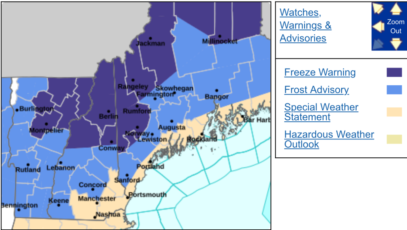
Frost advisory hath been giveth