All Activity
- Past hour
-
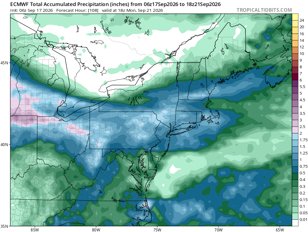
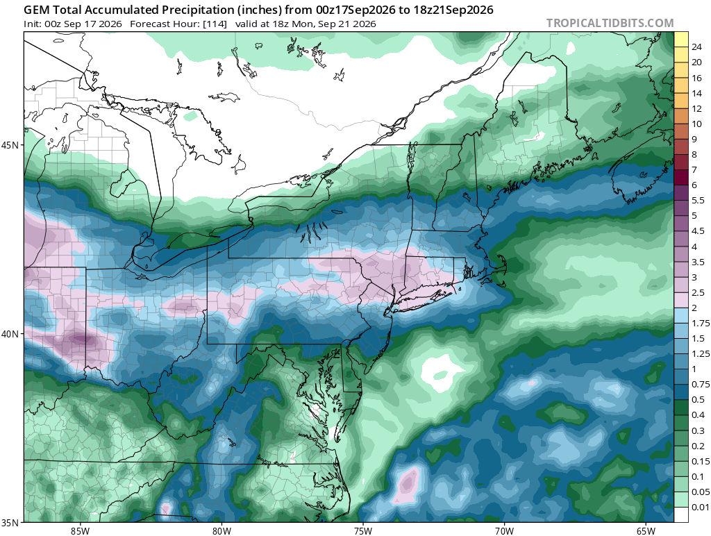
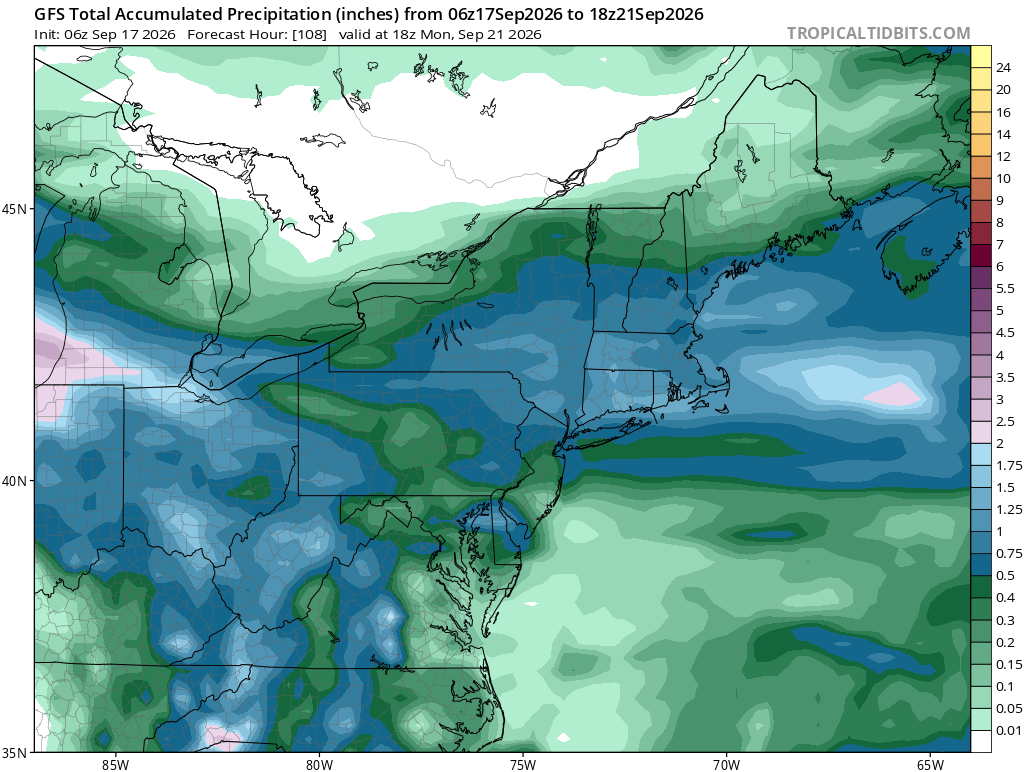
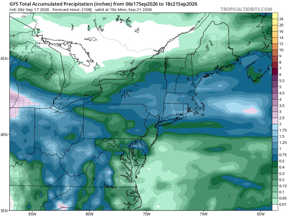
Potential for heavy rainfall has made it into rhe wording for sunday. What are we talking? Another 3 to 6 inches?
-
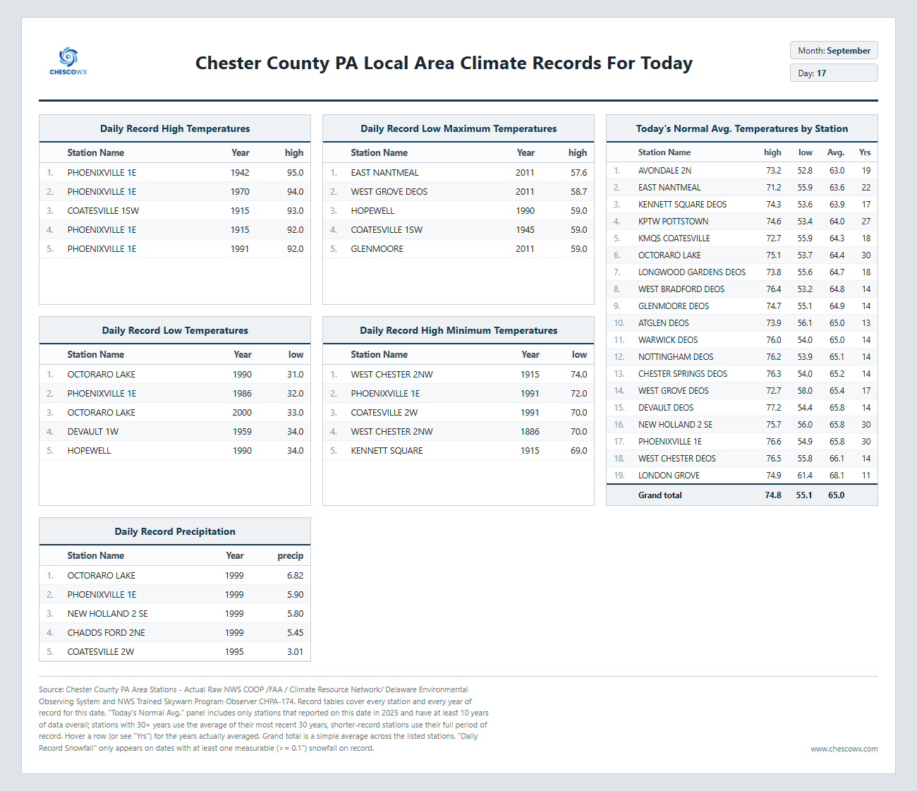
Highs: EWR: 95 (1991) NYC: 93 (1991) LGA: 95 (1991) JFK: 90 (1991) Lows: EWR: 44 (1950) NYC: 45 (1986) LGA: 48 (1986) JFK: 48 (1958) Historical: 1911: Pipestone, MN is hit with baseball-sized hail that smashes numerous windows at the Calumet Hotel and high school. The local observer measured hail three inches deep. People got their photos taken in automobiles surrounded by the icy white ground. (Ref. AccWeather Weather History) 1932 - Concord NH was drenched with 5.97 inches of rain in 24 hours to establish a record for that location (16th- 17th). (The Weather Channel) 1947: A Hurricane moved in from the Atlantic over Palm Beach and Broward Counties in Florida. Hurricane force winds were experienced along the Florida East Coast from Cape Canaveral to Carysfort Reef Light, south of Miami, while winds of over 100 mph were felt from the northern portion of Miami to north of Palm Beach, or about 70 miles. A 1-minute maximum wind speed of 155 mph was recorded at the Pompano Beach light station. Dozens of people were killed in this storm. It went on to hit the New Orleans, LA area. (Ref. Wilson Wx. History) 1957: Tropical Storm Ester hits the Louisiana Coast. (Ref. Daily News Record Newspaper - Harrisonburg, Virginia) 1960: 23 inches of snow at Rawlins, WY and over 20 inches at Lander set new early season snowfall records for both locations. (Ref. AccWeather Weather History) 1961: A powerful thunderstorm struck Las Vegas, NV with high winds and huge hailstones that racked up the community from one end to the other. The Strip was especially hit hard by the sudden fury of the storm, which blasted down virtually all of the big signs in the resort area and tore part of the roof off the Dunes Hotel. Dozens of homes and businesses had roofs ripped off and/or windows broken by the winds which had gusts to an estimated 80 mph and golf ball sized hail. (Ref. Wilson Wx. History) 1963 - Nearly two and a half inches of rain fell at Yuma AZ in 24 hours. It was the most intense rain for Yuma during the period between 19S09 and 1977. (The Weather Channel) 1965 - A storm produced a band of heavy snow across parts of Wyoming. Totals of 23 inches at Rawlins and 20.7 inches at Lander easily surpassed previous snowfall record totals for so early in the season. (15th-17th) (The Weather Channel) 1971: Boulder, CO was buried under 21 inches of snow and Denver recorded 15.6 inches. Damage to trees and power lines was extensive due to the snow being wet and heavy. Record breaking cold followed the early season snowstorm. Further north, 8 inches of snow fell at Red Lodge, MT beginning the day before ending on this date. Other totals included: Mystic Lake, MT: 5 inches, Livingston, MT: 1 inch and a trace reported at Billings, MT. (Ref. AccWeather Weather History) 1987 - Thunderstorms produced large hail, damaging winds, and heavy rain in the northeastern U.S. Heavy rain in southwestern Pennsylvania forced evacuation of twenty homes along Four Mile Run Creek, near Darlington. Harrisburg PA established a record for the date with 2.11 inches of rain. A cold front in the central U.S. brought freezing temperatures to parts of Montana and Wyoming. (The National Weather Summary) (Storm Data) 1988 - Early in the morning a tornado hit Kelly Air Force Base in San Antonio, TX, injuring three persons and causing twenty-eight million dollars damage. A second tornado on the northwest side of San Antonio caused six million dollars damage, and a third tornado in Bexar County killed one person and injured another. Thunderstorms associated with Hurricane Gilbert spawned a total of forty-seven tornadoes in a two day period, with forty of those tornadoes in central and south central Texas. (Storm Data) (The National Weather Summary) 1989 - Hurricane Hugo hit the Virgin Islands, producing wind gusts to 97 mph at Saint Croix. Hurricane Hugo passed directly over the island of Saint Croix causing complete devastation and essentially cutting off the island from communications. A storm surge of five to seven feet occurred at Saint Croix. The only rain gauge left operating, at Caneel Bay, indicated 9.40 inches in 24 hours. Hurricane Hugo claimed the lives of three persons at Saint Croix, and caused more than 500 million dollars damage. A ship, Nightcap, in the harbor of Culebra, measured wind gusts as high as 170 mph. A cold front brought high winds to the Great Basin and the Rocky Mountain Region, and thunderstorms along the cold front produced wind gusts to 66 mph at Yellowstone Park WY. (Storm Data) (The National Weather Summary) 2000: For the second straight day, the record high of 95° at Denver, Co set three records: 1.) New record high for the date. 2.) The warmest reading for this late in the year. 3.) It marked the 61st day during the year the temperature reached 90° or above, beating the record set the previous day and first set on 9/29/1994. Cheyenne reached a high of 91°, which is the latest day in history that Cheyenne reached at least 90°. Other daily record highs included: Rapid City, SD: 101°, Scottsbluff, NE: 99°, Bishop, CA: 97°-Tied, Pueblo, CO: 96°, Winslow, AZ: 96°-Tied, Clayton, NM: 95 °F. (Ref. Wilson Wx. History) 2004 - The remnants of Hurricane Ivan submerged Pittsburgh in 5.95 inches of rain in one day. That is the most rainfall Pittsburgh has seen in a 24-hour period since records began in 1876.
-
78 / 68 clouds and some showers into WNJ. Warm / humid upper 70s to low 80s where / when enough sun comes out. Warm again Friday low - mid 80s in the warmest spots as the ridge TN valley ridge begins to wane Overall near to below normal and potential for cut off lows / persistent onshore flow through the 26th. Looking warmer beyond there overall.
-
coming up to NH to do some hiking next weekend...will be stopping off at Tree House for supplies on the way up because that's what we all do down here when we venture north...that being said, anyone have recommendations for maybe lesser known breweries that are can't miss if we are staying in Lincoln?
-
 http://menon36.com/# Buy Tadalafil 10mg
 -

Septorcher 2026 Discussion - Endless Summer
powderfreak replied to Damage In Tolland's topic in New England
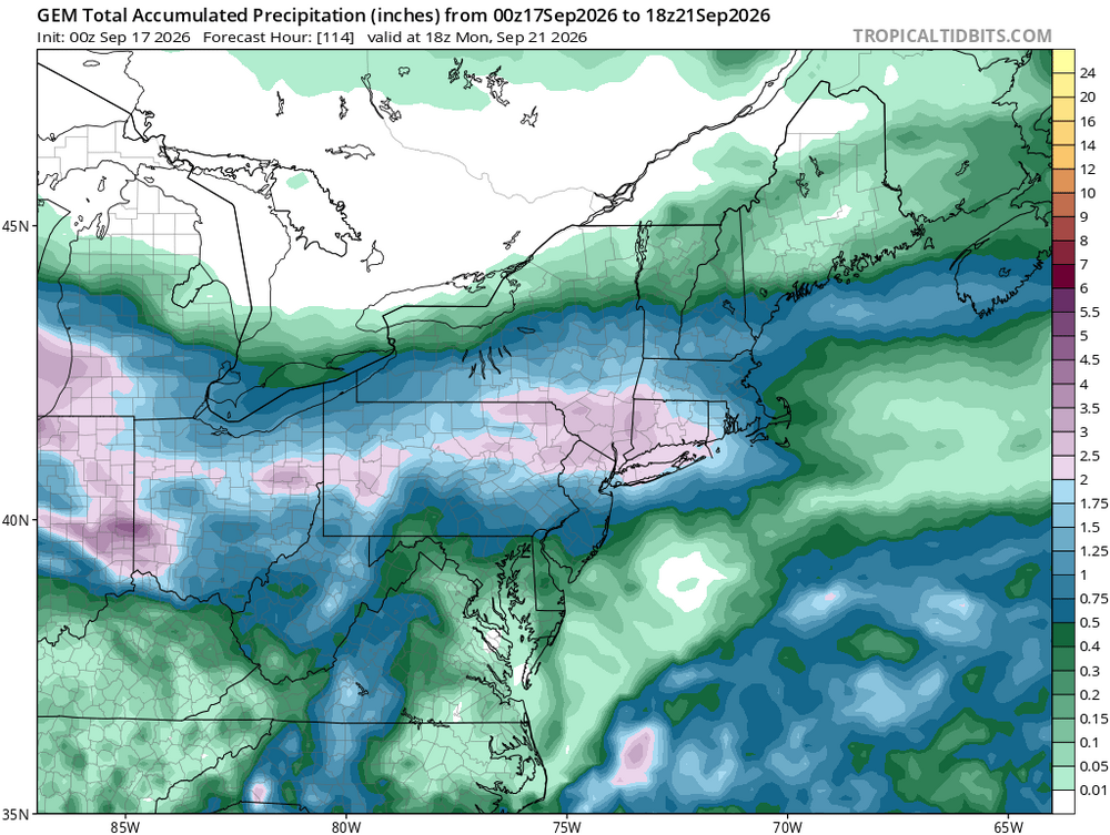
I'm curious what it would take to have you feel good about rain. The last one had models showing 1+" and you weren't inspired, then got 2". This doesn't look big but it would be hard to completely miss rain on this through Monday.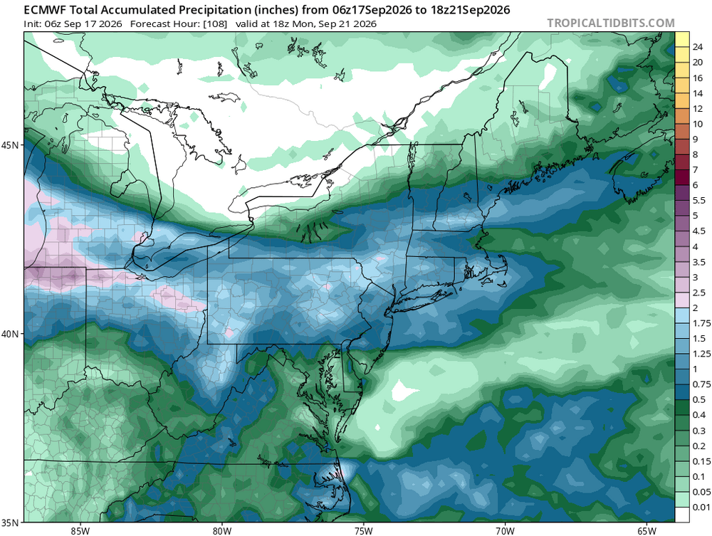
-
Generic Cialis price: menon36 - Tadalafil price
-
over
-

Mid-Long Range Discussion 2026
WinstonSalemArlington replied to BooneWX's topic in Southeastern States
maybe -
FWIW: The last 3 even years (2020, 2022, and 2024) all had record 75+ warmth (at PHL) in early November. All of these years had a +QBO. 2020-11-06 71 46 58.5 8.0 6 0 0.00 0.0 0 2020-11-07 75 47 61.0 10.9 4 0 0.00 0.0 0 2020-11-08 76 46 61.0 11.2 4 0 0.00 0.0 0 2020-11-09 75 47 61.0 11.6 4 0 0.00 0.0 0 2020-11-10 76 48 62.0 12.9 3 0 0.00 0.0 0 2020-11-11 71 61 66.0 17.2 0 1 1.48 0.0 0 Nov 2020 QBO: +11.15 2022-11-01 74 58 66.0 13.8 0 1 0.13 0.0 0 2022-11-02 71 51 61.0 9.1 4 0 0.00 0.0 0 2022-11-03 72 45 58.5 7.0 6 0 0.00 0.0 0 2022-11-04 73 47 60.0 8.8 5 0 0.00 0.0 0 2022-11-05 78 56 67.0 16.2 0 2 0.00 0.0 0 2022-11-06 77 67 72.0 21.5 0 7 T 0.0 0 2022-11-07 79 56 67.5 17.4 0 3 0.00 0.0 0 2022-11-10 70 43 56.5 7.4 8 0 0.00 0.0 0 2022-11-11 72 57 64.5 15.7 0 0 0.44 0.0 0 2022-11-12 71 60 65.5 17.1 0 1 0.07 0.0 0 Nov 2022 QBO: +12.45 2024-11-01 81 57 69.0 16.8 0 4 T 0.0 0 2024-11-05 76 50 63.0 12.2 2 0 0.00 0.0 0 2024-11-06 80 61 70.5 20.0 0 6 0.00 0.0 0 2024-11-07 78 58 68.0 17.9 0 3 0.00 0.0 0 2024-11-08 72 49 60.5 10.7 4 0 0.00 0.0 0 2024-11-11 74 54 64.0 15.2 1 0 0.15 0.0 0 Nov 2024 QBO: +13.78
-
(002).thumb.png.6e3d9d46bca5fe41aab7a74871dd8af8.png)
Central PA Summer 2026 Discussion/Obs Thread
ChescoWx replied to Voyager's topic in Upstate New York/Pennsylvania
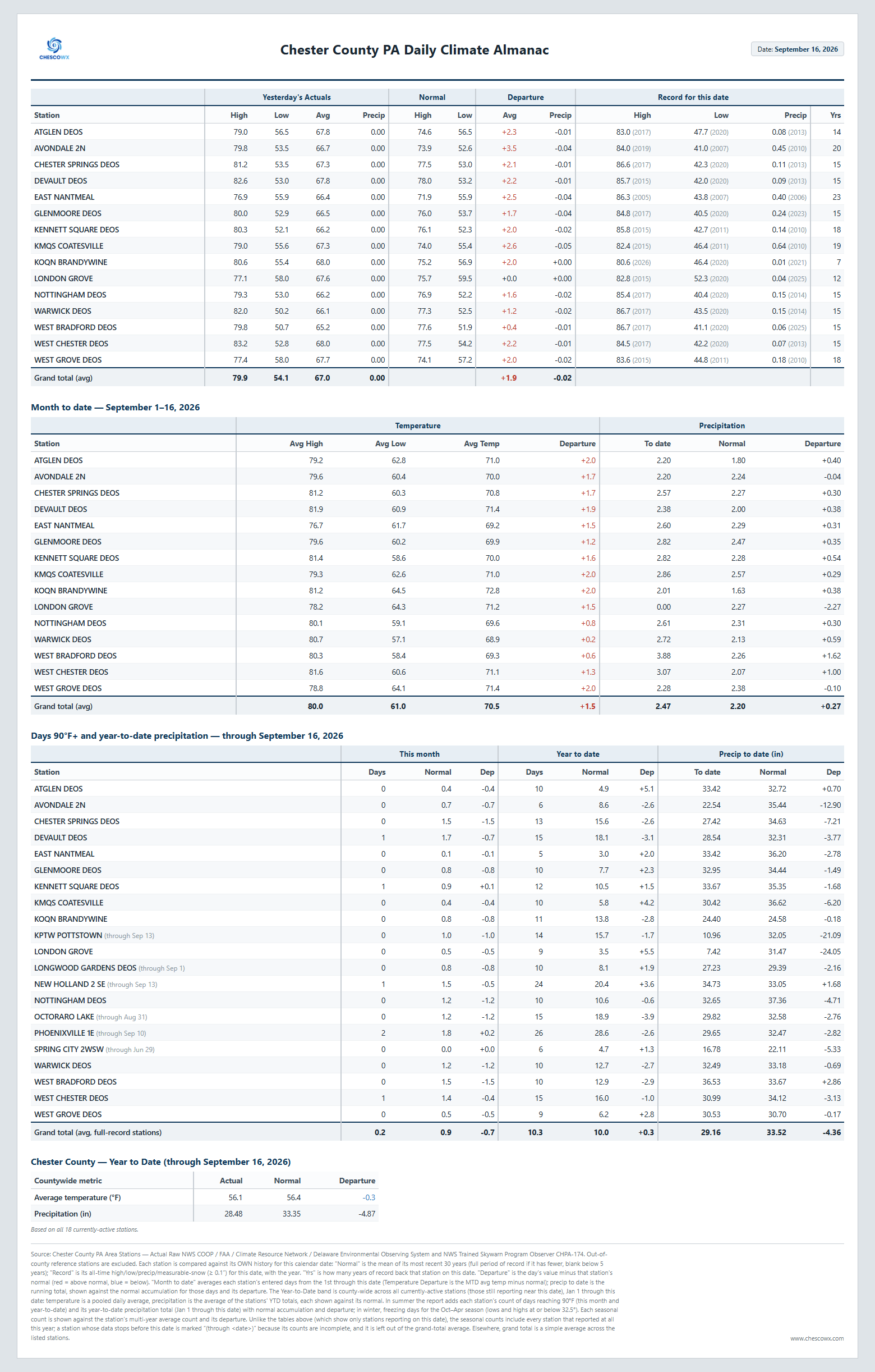
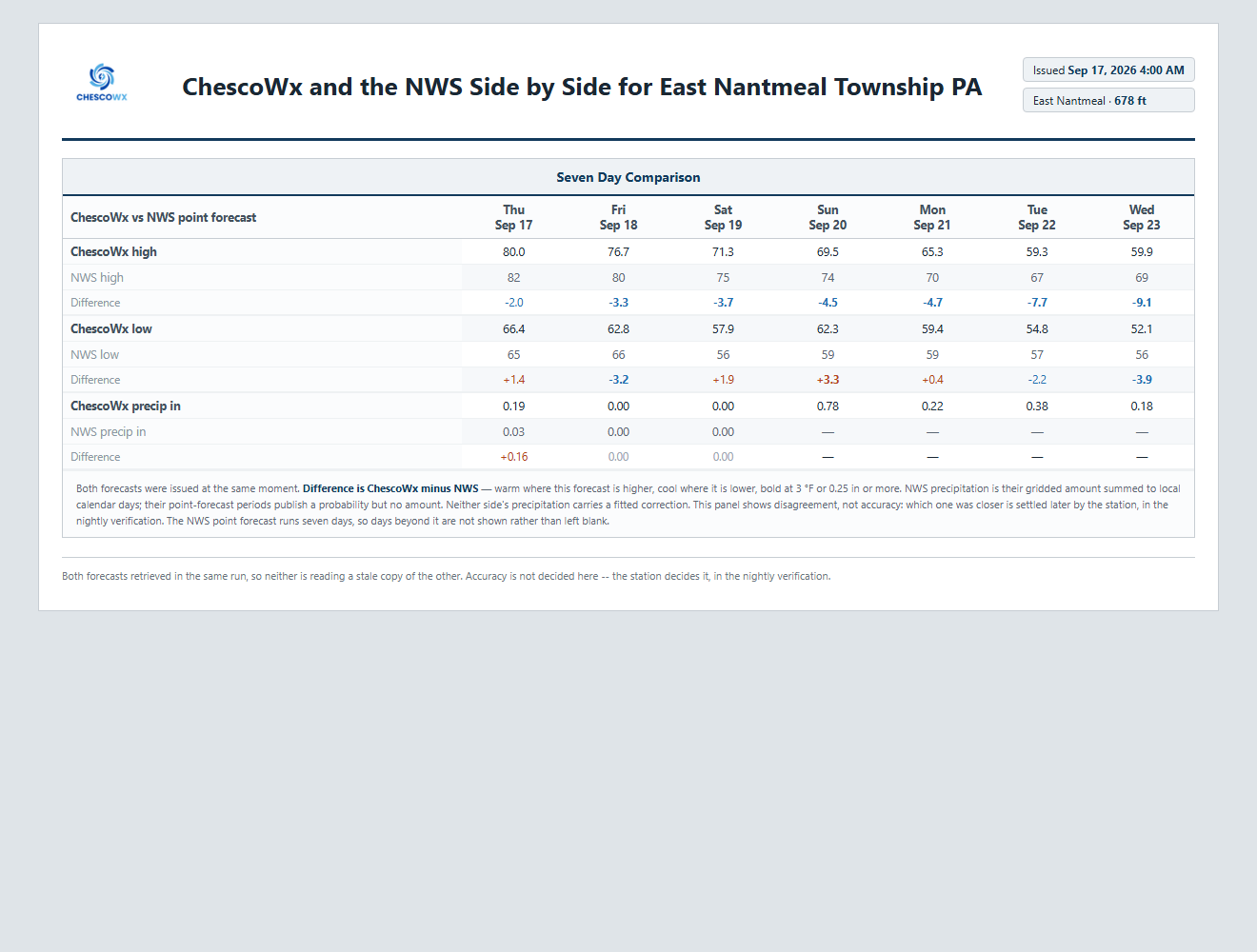
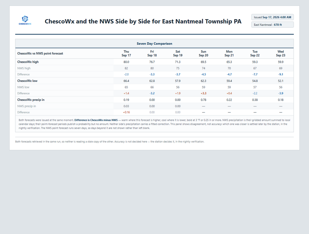
Today will turn noticeably more humid with temperatures around 5 degrees above normal in the lower 80's for most spots. We could see a brief shower in spots this morning. A cold front crosses the area late tonight with maybe a couple showers. We turn a bit cooler and less humid tomorrow and Saturday with near normal temperatures. Rain chances increase by late Saturday night and look to last through the day on Sunday. We turn unseasonably chilly to start the new work week with my backyard ChescoWx model forecast keeping afternoon highs both Tuesday and Wednesday in the upper 50's.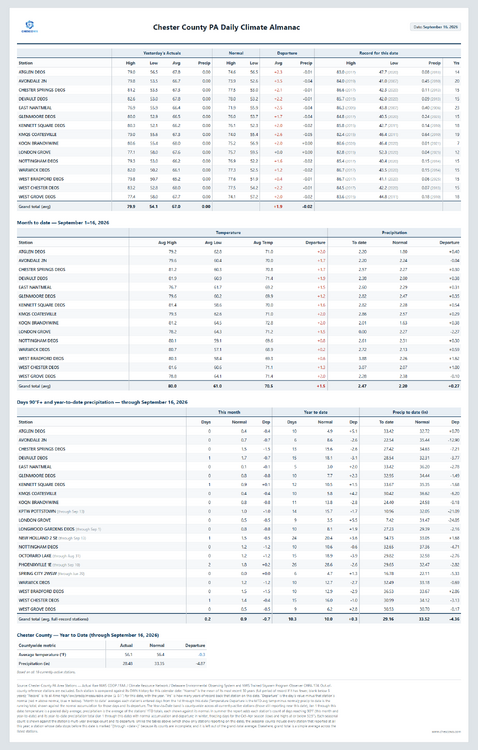
-
Buy Tadalafil 5mg: MenOn36 - Cialis without a doctor prescription
-
Picked up 0.99” overnight. Most rain we’ve had since the end of July and nearly doubling our August-September total so far. Glad to have it.
-
E PA/NJ/DE Autumn 2026 Obs/Discussion
ChescoWx replied to PhiEaglesfan712's topic in Philadelphia Region
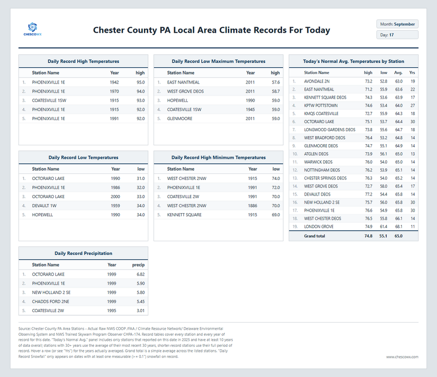
Today will turn noticeably more humid with temperatures around 5 degrees above normal in the lower 80's for most spots. Some spots will see a shower this morning. A cold front crosses the area late tonight with maybe a couple showers. We turn a bit cooler and less humid tomorrow and Saturday with near normal temperatures. Rain chances increase by late Saturday night and look to last through the day on Sunday. We turn unseasonably chilly to start the new work week with my backyard ChescoWx model forecast keeping afternoon highs both Tuesday and Wednesday in the upper 50's.
-
Many here last week were promoting mid to upper 80's for Weds and Thursday.
-

Septorcher 2026 Discussion - Endless Summer
TauntonBlizzard2013 replied to Damage In Tolland's topic in New England
The next two rain chances look really uninspiring. Some showers later today north of the pike and maybe some rain Sunday evening? Looks like that one favors the same areas that have gotten it all summer, west and southern CT. Definitely doesn’t look like anything you can count on - Today
-
late fri/sat looks like another nice train setup somewhere of n il, the trend of zzzzs and followed by a few inches looks to continue
-
.thumb.gif.f92b16c631a1d15d405ed77b33f0710d.gif)
Septorcher 2026 Discussion - Endless Summer
Torch Tiger replied to Damage In Tolland's topic in New England
Was an OK storm for Cape Cod, we had 60-70mph gusts. I always felt slighted by Floyd though, another 50mi east with less land interaction and that was close to a hurricane there -

Septorcher 2026 Discussion - Endless Summer
tamarack replied to Damage In Tolland's topic in New England
5.88" here with gusts in the 40s, our most recent significant TC. Only 0.11" from being our biggest rain event, which came in June 1998, our first full month after moving here. -

Septorcher 2026 Discussion - Endless Summer
kdxken replied to Damage In Tolland's topic in New England
Haw haw -
Had the wrong day posted LOL. Corrected.
-
Feb-Mar 1993 was epic, with 7 storms 7" to 14.5", totaling (with some small events) over 80". The superstorm brought the pack to 31", tallest in our 13 winters in Gardiner. That capping event was a bit disappointing at our place, if a double-digit snowfall can disappoint. Listening to "1-3 feet with life-threatening conditions" had me primed for a storm of the lifetime. Instead, we had 10.3" of heavily rimed 6:1 flakes, almost the lowest report in New England and 3rd biggest of the winter. (BHB and Block Island had 10.0".) Temps during the storm were upper teens to 20. The storm did bring wind 30-45 mph. A favorite wind report at 8 AM - BGR was calm while 50 miles to the SE, Mt. Desert Rock reported 60 knots.
-
September 17 1955: A late-season tornado hits Koochiching County. Most damage is confined to trees. 1911: Pipestone is hit with baseball-sized hail that smashes numerous windows at the Calumet Hotel and high school. The local observer measures hail three inches deep. People get their photos taken in automobiles surrounded by the icy white ground. For Thursday, September 17, 2026 1932 - Concord NH was drenched with 5.97 inches of rain in 24 hours to establish a record for that location (16th- 17th). (The Weather Channel) 1963 - Nearly two and a half inches of rain fell at Yuma AZ in 24 hours. It was the most intense rain for Yuma during the period between 1909 and 1977. (The Weather Channel) 1965 - A storm produced a band of heavy snow across parts of Wyoming. Totals of 23 inches at Rawlins and 20.7 inches at Lander easily surpassed previous snowfall record totals for so early in the season. (15th-17th) (The Weather Channel) 1987 - Thunderstorms produced large hail, damaging winds, and heavy rain in the northeastern U.S. Heavy rain in southwestern Pennsylvania forced evacuation of twenty homes along Four Mile Run Creek, near Darlington. Harrisburg PA established a record for the date with 2.11 inches of rain. A cold front in the central U.S. brought freezing temperatures to parts of Montana and Wyoming. (The National Weather Summary) (Storm Data) 1988 - Early in the morning a tornado hit Kelly Air Force Base in San Antonio, TX, injuring three persons and causing twenty-eight million dollars damage. A second tornado on the northwest side of San Antonio caused six million dollars damage, and a third tornado in Bexar County killed one person and injured another. Thunderstorms associated with Hurricane Gilbert spawned a total of forty-seven tornadoes in a two day period, with forty of those tornadoes in central and south central Texas. (Storm Data) (The National Weather Summary) 1989 - Hurricane Hugo hit the Virgin Islands, producing wind gusts to 97 mph at Saint Croix. Hurricane Hugo passed directly over the island of Saint Croix causing complete devastation and essentially cutting off the island from communications. A storm surge of five to seven feet occurred at Saint Croix. The only rain gauge left operating, at Caneel Bay, indicated 9.40 inches in 24 hours. Hurricane Hugo claimed the lives of three persons at Saint Croix, and caused more than 500 million dollars damage. A ship, Nightcap, in the harbor of Culebra, measured wind gusts as high as 170 mph. A cold front brought high winds to the Great Basin and the Rocky Mountain Region, and thunderstorms along the cold front produced wind gusts to 66 mph at Yellowstone Park WY. (Storm Data) (The National Weather Summary) 2004 - The remnants of Hurricane Ivan submerged Pittsburgh in 5.95 inches of rain in one day. That is the most rainfall Pittsburgh has seen in a 24-hour period since records began in 1876. Observances: 17 Thu Citizenship Day 17 Thu National Pet Bird Day 17 Thu International Country Music Day 17 Thu Constitution Day 17 Thu Time's Up Day 17 Thu World Patient Safety Day 17 Thu International Patient Safety Day 17 Thu International Grenache Day 17 Thu National Arielle K. Sterrett Day 17 Thu National DEI Day 17 Thu National Monte Cristo Day 17 Thu National Pet Carbon Monoxide (CO) Safety Day 17 Thu National Professional House Cleaners Day 17 Thu National Table Shuffleboard Day 17 Thu Smithsonian Day 17 Thu National Apple Dumpling Day
-
Low of 63.
-

Septorcher 2026 Discussion - Endless Summer
mreaves replied to Damage In Tolland's topic in New England
@dendrite @Chrisrotary12 As drought expands across central NH again this fall, in some places it never fully went away