All Activity
- Past hour
-
 ICON and RGEM both look abysmal
 -

The return of the elusive Nor'easter. Drought buster or bust?
ravensrule replied to dailylurker's topic in Mid Atlantic
I’m guaranteeing you 2” if you follow my instructions. -
Yeah looks like a weak nor'easter, nothing we haven't seen a billion times. Wish it missed but we do need the rain.
-
Would’ve loved radar from this point. Cool storm
-

The return of the elusive Nor'easter. Drought buster or bust?
CAPE replied to dailylurker's topic in Mid Atlantic
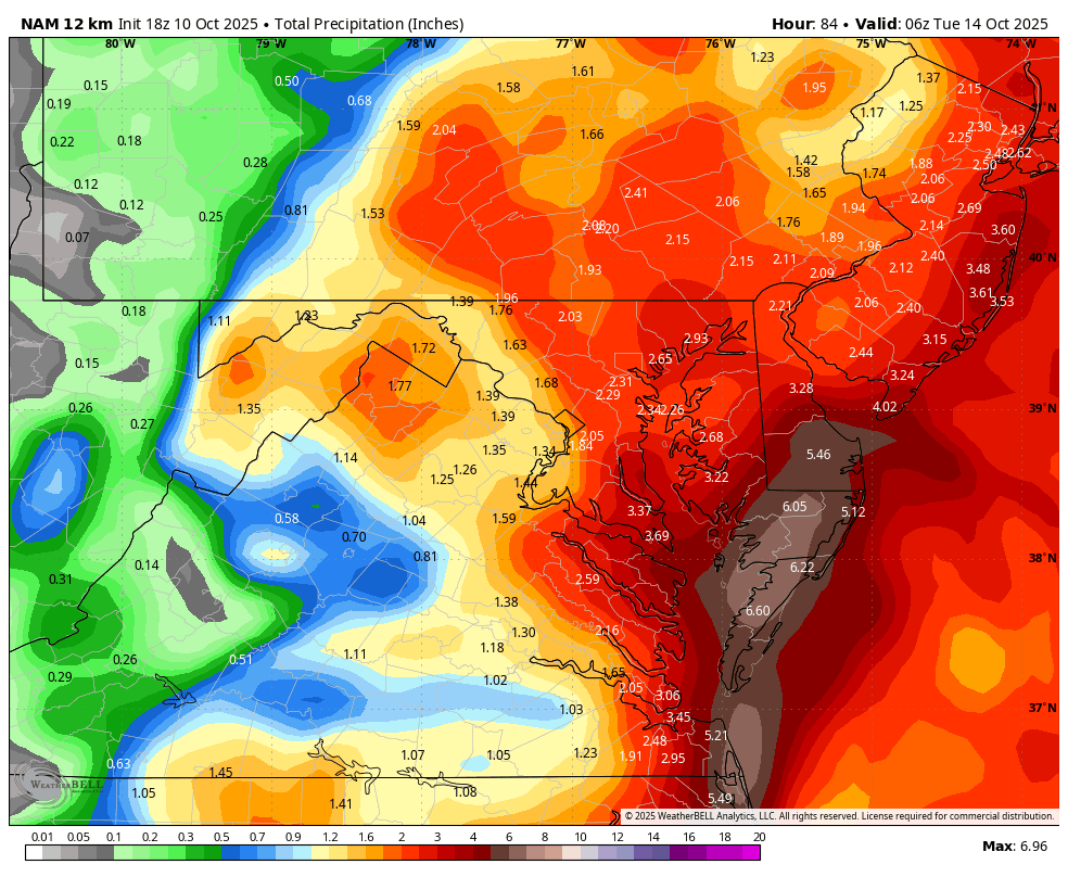
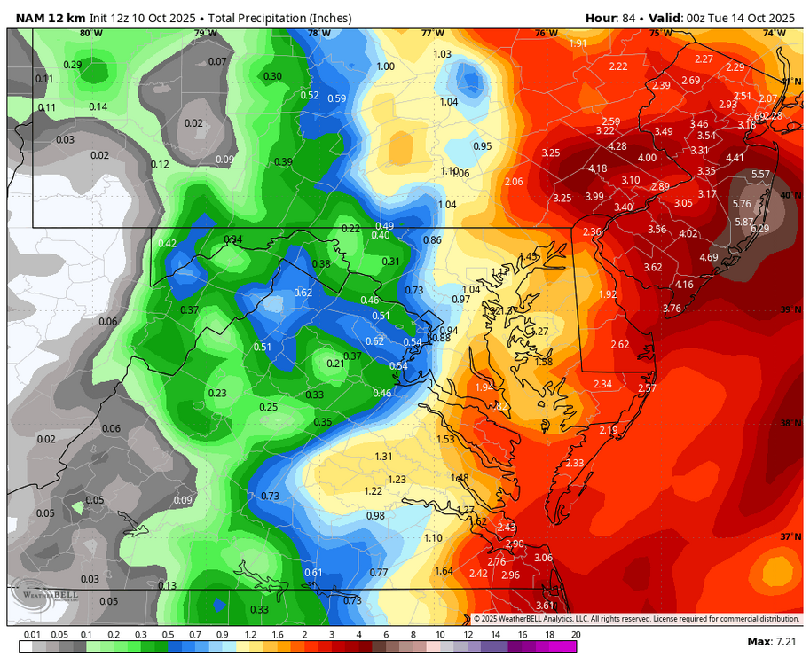
Mount Holly still sticking with the general idea of a high impact event. This little snippet is semi-interesting from their AFD- Guidance will likely continue to struggle and vary from run to run with this system until it actually forms a well defined low pressure center sometime Saturday or Saturday night. All previously issued watches remain in effect at this time due to the continued uncertainty in timing, severity, and inland extent of impacts. -
 It’s doing its typical over amped garbage.
 -
Temperatures started out the day in the 30s and 40s across the region. The coldest spots saw readings drop into the upper 20s. Lows included: Albany: 31° Atlantic City: 40° Binghamton: 31° Boston: 41° Bridgeport: 40° Danbury: 31° Hartford: 29° Islip: 40° Montgomery: 26° (old record: 27°, 2000) New Haven: 39° New York City-Central Park: 46° New York City-JFK Airport: 43° New York City-LaGuardia Airport: 48° Newark: 41° Philadelphia: 45° Poughkeepsie: 28° Sussex: 29° Trenton: 39° Westhampton: 31° White Plains: 42° Temperatures will moderate during the weekend, but rain will arrive on Sunday. Highs should reach the middle and upper 60s tomorrow and lower and middle 60s on Sunday. A strong nor'easter will bring periods of rain and strong winds to parts of the region. Uncertainty as to amounts and locations of the heaviest rainfall has increased on the guidance, as a complex phasing situation is involved. For now, it still appears that a general 1"-3" rainfall is likely across New York City and its nearby suburbs, along with winds that will gust past 40 mph. Long Island could see 2"-4" of rain. Winds in this region could gust to 60 mph. There is the potential for lesser rainfall amounts along the Jersey Shore, but that is not yet certain. More revisions may be necessary after the overnight model cycles. A period of near normal to somewhat below normal temperatures and dry conditions will likely follow the nor-easter. In the 18 past years where Central Park saw at least two 80° or above highs and Newark saw at least two 84° or above highs during the first week of October, the temperature returned to 70° or above on at least one day during the second half of October in 17 (94.4%) of those cases. For all other cases, 84.1% saw at least one such high temperature during the second half of October. Therefore, the sharp cool spell very likely won't mean that New York City has seen its last 70° or above high temperature. The ENSO Region 1+2 anomaly was -0.1°C and the Region 3.4 anomaly was -0.5°C for the week centered around October 1. For the past six weeks, the ENSO Region 1+2 anomaly has averaged -0.15°C and the ENSO Region 3.4 anomaly has averaged -0.43°C. La Niña conditions will likely continue through mid-winter. The SOI was +18.82 today. The preliminary Arctic Oscillation (AO) was +1.044 today. Based on sensitivity analysis applied to the latest guidance, there is an implied 61% probability that New York City will have a warmer than normal October (1991-2020 normal). October will likely finish with a mean temperature near 58.9° (1.0° above normal). Supplemental Information: The projected mean would be 2.0° above the 1981-2010 normal monthly value.
-

The return of the elusive Nor'easter. Drought buster or bust?
yoda replied to dailylurker's topic in Mid Atlantic
SHORT TERM /6 AM SATURDAY MORNING THROUGH SUNDAY NIGHT/... A coastal low pressure system will take shape off of the Southeast U.S. Coast tonight through midday Saturday, before moving north along the Eastern Seaboard Saturday afternoon through Sunday night. An occasional shower or sprinkles could evolve Saturday into Saturday evening from southeast to northwest across the region. A light to moderate steadier rainfall could arrive in several bands overnight Saturday through Sunday night as the coastal low gets closer to the mid- Atlantic region and nearly stalls. Rain amounts could average 1 to 2 inches along and east of a line from Hagerstown to Warrenton to Fredericksburg. To the west of this line, one-half to three-quarters of an inch. The heaviest rainfall could reach the 3 to 3.5 inch amounts in places. The interaction between the departing area of high pressure off the New England Coast and the coastal low pressure system will result in stronger northeast winds to develop and persist through much of the weekend. An elongated trough of low pressure, accompanied by a few mid-level disturbances, will help to tighten the pressure gradient Saturday through Sunday to result in stronger northeasterly winds. Northeast winds will increase late Saturday night through Sunday afternoon with sustained winds of 10 to 20 mph gusting 25 to 30 mph. Winds could gust 35 to 40 mph over land within a several miles of the Chesapeake Bay shoreline. A big uncertainty remains in the track and intensity of coastal low, simultaneously, as it moves up the coast. Also, to make matters even less certain, is the interaction or phasing of the mid- level disturbances with the coastal low and the exact location of that occurrence. && .LONG TERM /MONDAY THROUGH FRIDAY/... Breezy and wet conditions likely continue into Monday, and perhaps even into the first half of Tuesday, as the coastal low meanders off the Delmarva Peninsula before eventually pulling further offshore on Tuesday. There seems to be a decent amount of agreement that precipitation should taper off by Tuesday afternoon as the low shift further to the east. However, it remain close enough that winds may still remain elevated for a couple days thereafter. -
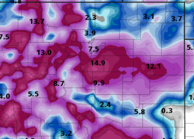
NAM doubles down
.thumb.png.9607bd48c6ca2896ca02ee8e2898d859.png)
-
Congrats to the Euro for being the first of the season to show a long range lala land snowstorm
-

The return of the elusive Nor'easter. Drought buster or bust?
Weather Will replied to dailylurker's topic in Mid Atlantic
Big shift west on WB 12K NAM....will post the maps when the run completes.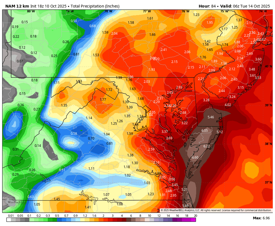
-

"Potentially" powerful Nor'easter Sun-Mon 10/12-13/25 with needed rain-especially south of I84, and fairly high impact sct coastal gusts 50+ MPH and possibly moderate or greater coastal flooding at the midday Sun and Monday high tide cycles.
LibertyBell replied to wdrag's topic in New York City Metro
Those things are absolutely useless. I got one in 2005 and had two months of fun with a digital rain gage measuring heavy rains in September and October 2005 and then the thing broke. Got one after that and it also broke after a heavy rainfall. Now I just measure rain in a marked glass tube. -
It sounds like May 1977 but in the opposite direction.
-

"Potentially" powerful Nor'easter Sun-Mon 10/12-13/25 with needed rain-especially south of I84, and fairly high impact sct coastal gusts 50+ MPH and possibly moderate or greater coastal flooding at the midday Sun and Monday high tide cycles.
cleetussnow replied to wdrag's topic in New York City Metro
Burn your snow stake please.- 196 replies
-
- 1
-

-
- heavy rain
- damaging wind
- (and 2 more)
-
"Potentially" powerful Nor'easter Sun-Mon 10/12-13/25 with needed rain-especially south of I84, and fairly high impact sct coastal gusts 50+ MPH and possibly moderate or greater coastal flooding at the midday Sun and Monday high tide cycles.
cleetussnow replied to wdrag's topic in New York City Metro
Right up until the line forms on the GW bridge every damn week -
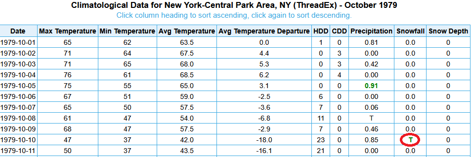
NYC had a trace of snow on October 10, 1979. The snow fell but didn't accumulate.
-
 Is it true that Joe Bastadi called this the storm of the century earlier this week?
- 196 replies
-
- 2
-

-
- heavy rain
- damaging wind
- (and 2 more)
-
What a waste of a named storm ....i had full hope that Karen would take out the entire east coast from Florida to New England....
-

Spooky Season (October Disco Thread)
dendrite replied to Prismshine Productions's topic in New England
He had a low of 19.8° and a low of 20° - Today
-
 Oh let's not forget we still have a fairly decent leaf canopy on the trees still. ..
 -
"Potentially" powerful Nor'easter Sun-Mon 10/12-13/25 with needed rain-especially south of I84, and fairly high impact sct coastal gusts 50+ MPH and possibly moderate or greater coastal flooding at the midday Sun and Monday high tide cycles.
LibertyBell replied to wdrag's topic in New York City Metro
you're going to get your first freeze before you get any kind of meaningful rain -
wow in none of these three DC October snowstorms did NYC get any snow?
-
Was the big miss February 1989? I remember that storm. a 6-8 inch virga storm and in a very cold December 1989 we had a 6-8 inch rainstorm with blown winter storm warnings in both events.


.png.0d71de794d2e04b652498e75e53aeba9.png)