All Activity
- Past hour
-
The forecast for the New England game now includes "snow likely."
-

Storm potential January 17th-18th
hudsonvalley21 replied to WeatherGeek2025's topic in New York City Metro
Yup they bumped up esp. inland. -

First Legit Storm Potential of the Season Upon Us
Go Kart Mozart replied to 40/70 Benchmark's topic in New England
A little bit less WOR, a tad better Emass. Predecessor looking decent. -
You start with mostly cloudy skies and cold, northwest flow for a day or two. Around mid afternoon on day three, warm air moves in aloft and starts precip as freezing rain. It then flips to steady, moderate snow overnight. Precipitation falls without the benefit of sunshine to melt it off overnight, and road crews were unable to put pretreatment down due to rain. The snow encapsulates power lines and trees overnight, leading to over 250,000 outages across the DC - Baltimore region. Gusty NW winds of around 20 mph occur after the storm exits around sunrise. Early sunshine fades behind a cirrus shield the next day as a potent clipper system dives south into Kentucky. An additional 4" - 8" of fluffy snow occurs during the afternoon and evening.
-
TAKE COVER (Virga)
-

Central PA Winter 25/26 Discussion and Obs
Mount Joy Snowman replied to MAG5035's topic in Upstate New York/Pennsylvania
Most of the guidance I've looked at has a 6-10ish type timeframe for the main swath. Some show a separate batch breaking out ahead of the morning slug sometime during the overnight hours, but early morning seems the best bet for seeing accumulating flakes. -

First Legit Storm Potential of the Season Upon Us
Sey-Mour Snow replied to 40/70 Benchmark's topic in New England
Ya IF this storm even happens for us, it looks like paste, temps are borderline.. -

First Legit Storm Potential of the Season Upon Us
RUNNAWAYICEBERG replied to 40/70 Benchmark's topic in New England
Reggie a tic juiced this cycle. -

First Legit Storm Potential of the Season Upon Us
Typhoon Tip replied to 40/70 Benchmark's topic in New England
12z nam's doing that the 06z gfs left the conv alone and relies entirely on the synoptic q-g forcing not sure which is right -

Storm potential January 17th-18th
vegan_edible replied to WeatherGeek2025's topic in New York City Metro
reggie was the only model that sniffed out the surprise 4-7" storm that just hit the detroit. i think it has some merit in this game. euro is garbage, gfs worse. -

First Legit Storm Potential of the Season Upon Us
SouthCoastMA replied to 40/70 Benchmark's topic in New England
RGEM is warm here..rain ending as 1-2". woof NAM/ICON are the two models you'd want to be eastern outliers at least. -

First Legit Storm Potential of the Season Upon Us
dendrite replied to 40/70 Benchmark's topic in New England
Yeah…the s/w was a little more neggy. -
Reggie just wont quit It's the best of the bad models showing a hit of consequence.
-

First Legit Storm Potential of the Season Upon Us
CoastalWx replied to 40/70 Benchmark's topic in New England
The other thing I noticed is that some models are chasing convection. That might factor in too. -
First Legit Storm Potential of the Season Upon Us
CoastalWx replied to 40/70 Benchmark's topic in New England
Tightened the gradient a bit by ern CT but looked like .25” for you or so. -

First Legit Storm Potential of the Season Upon Us
MJO812 replied to 40/70 Benchmark's topic in New England
Icon did improve but not at the surface -

January 2026 Short/Medium Range Thread
WintryMixmaster replied to John1122's topic in Tennessee Valley
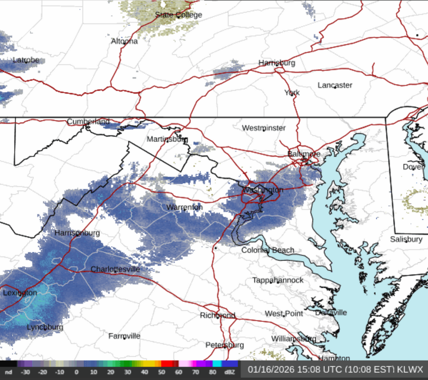
Satellite shows clearing skies to our west unfortunately, hopefully we can hold in as much cold air as we can ahead of the southwest winds. The temperature has been steadily climbing at my house, up to 28.6 degrees now -

First Legit Storm Potential of the Season Upon Us
TauntonBlizzard2013 replied to 40/70 Benchmark's topic in New England
I don’t know, I thought Reggie looked okay. Definitely not like the NAM. ICON is a whiff but I thought it improved a bit -
First Legit Storm Potential of the Season Upon Us
Sey-Mour Snow replied to 40/70 Benchmark's topic in New England
at work, did it spread wealth NW, or is it a scraper? -
26 out with the sun trying to hang on. Clouds are coming in though. So what is this I hear of a possible snow storm tomorrow? Looked at the other thread and is it correct that we could get a decent amount tomorrow? Reason for asking is the kid who goes to school in PA starts her second semester on Monday. So either tomorrow or Sunday is her travel day back. We had already this morning decided on Sunday but looking at the other thread that may confirm our choice. As she is now driving herself back and forth we do not want any bad weather. And she takes 15 all the way up until she has to shoot West to Carlisle.
-

First Legit Storm Potential of the Season Upon Us
ineedsnow replied to 40/70 Benchmark's topic in New England
Icon has been a miss. -
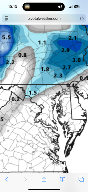
2-4 for NYC with slightly more to the and south from both events.
-
First Legit Storm Potential of the Season Upon Us
CoastalWx replied to 40/70 Benchmark's topic in New England
Yeah Reggie was decent here. -

Winter 2025-26 Medium/Long Range Discussion
CheeselandSkies replied to michsnowfreak's topic in Lakes/Ohio Valley
Just like it is in the opposite direction for warm fronts/tornadic supercells, with very rare exceptions. -
Icon with same idea.