All Activity
- Past hour
-
Yep, maples are at peak in my nhood, some are dropping leaves. Oaks are finally showing orange/brown/yellow and not all green. Overall, color is great! Peak here will be around Nov 5th, which is roughly average for my neck of the woods. Will be excellent color for a spooky halloween eve.
-
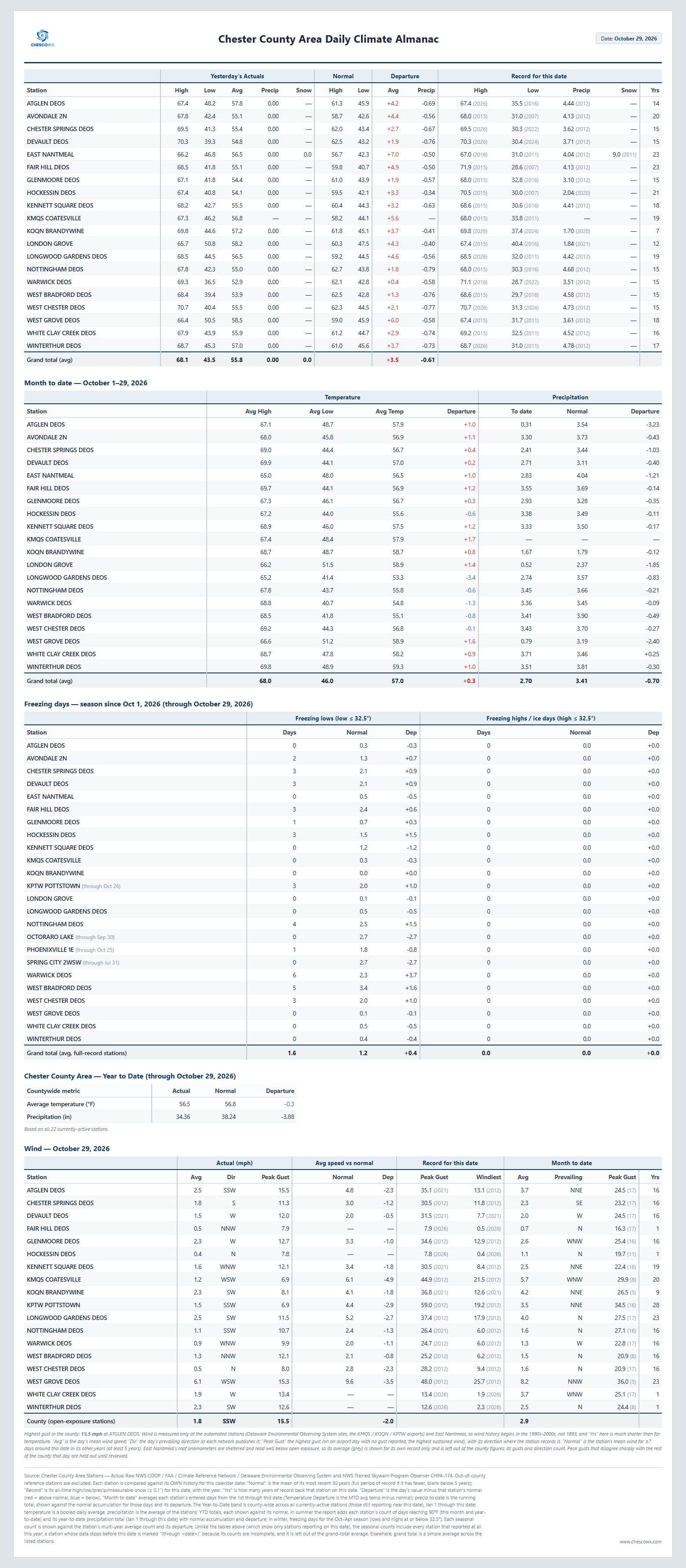
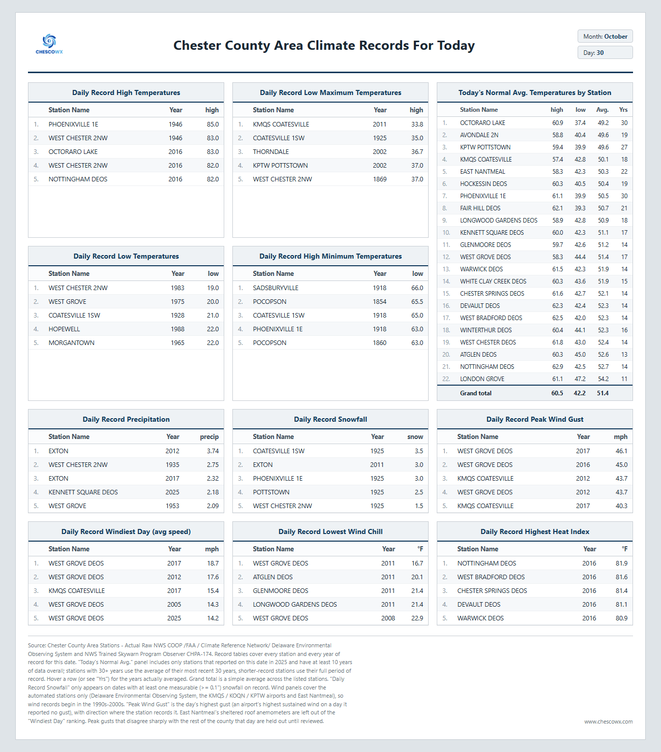
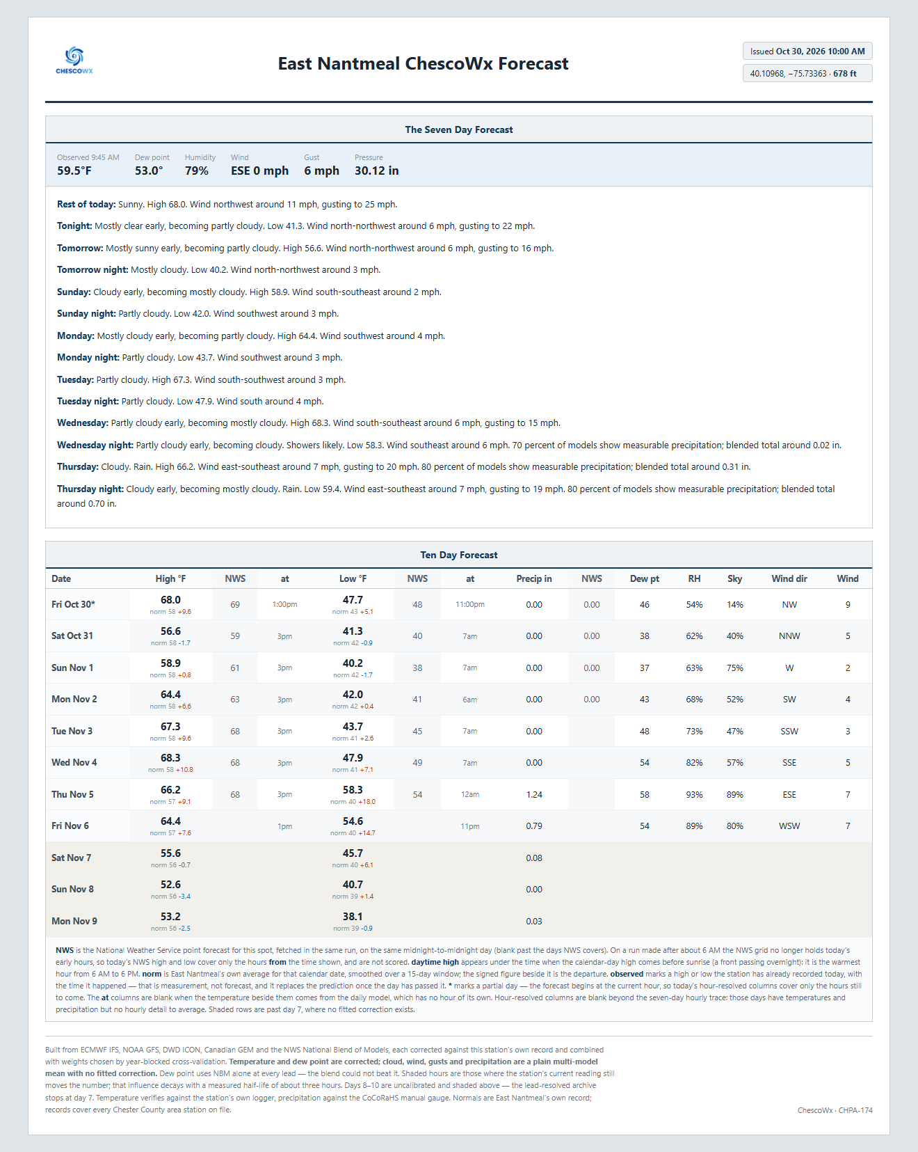
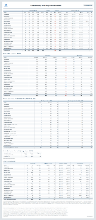
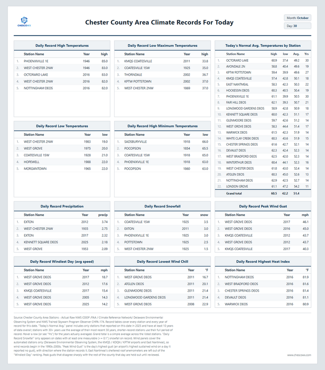
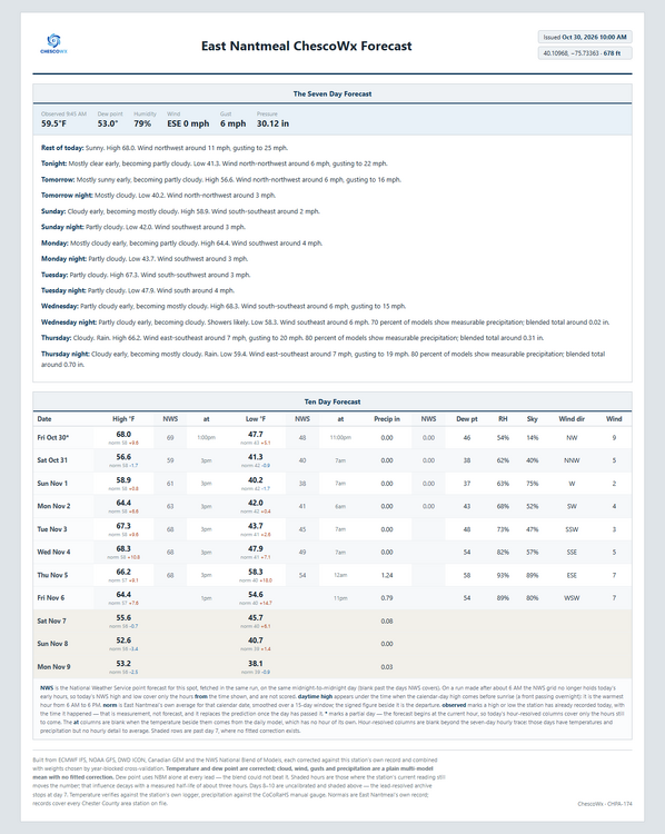
Of note on this date back in 1946 Phoenixville 1E hit 85 degrees and the county as a whole averaged 83.3 for a high...making it our warmest October 30th since records began in 1890. Nothing like that today but it will be very mild for the end of October with highs from upper 60's in ridge locations to the low 70's in valley spots. This is about 7 degrees above normal with lows tonight in the upper 30's to near 40. By Sunday morning we should see lows in the mid 30's to low 40's, not far from freezing in the colder valleys! Temperatures will be near normal this weekend but by Monday we warm to the upper 60's which is 3 to 14 degrees above normal. It has been a while since our last rain but our next soaking rain looks to arrive Thursday with around 1.2" possible according to the ChescoWx model.
-
It’s a very solid forecast. One blockbuster is the difference between an above normal season or struggling to get to 10”. We saw this in both 82/83 and 15/16 and on the opposite side 72/73 and 97/98. It’s an eggs all in one basket situation. .
-

E PA/NJ/DE Autumn 2026 Obs/Discussion
ChescoWx replied to PhiEaglesfan712's topic in Philadelphia Region
Of note on this date back in 1946 Phoenixville 1E hit 85 degrees and the county as a whole averaged 83.3 for a high...making it our warmest October 30th since records began in 1890. Nothing like that today but it will be very mild for the end of October with highs from upper 60's in ridge locations to the low 70's in valley spots. This is about 7 degrees above normal with lows tonight in the upper 30's to near 40. By Sunday morning we should see lows in the mid 30's to low 40's, not far from freezing in the colder valleys! Temperatures will be near normal this weekend but by Monday we warm to the upper 60's which is 3 to 8 degrees above normal. It has been a while since our last rain but our next soaking rain looks to arrive Thursday with around 1.2" possible according to the ChescoWx model.
-
 canadian pharmacy service and canadian pharmacy rx online canadian drugstore http://www.margaron.ru/bitrix/redirect.php?event1=&event2=&event3=&goto=http://canpointerx.shop cipa canada online pharmacy or https://bold-kw.com/user/abssmmwjkd/?um_action=edit best rated canadian pharmacy [url=https://www.google.co.uz/url?sa=t&url=https://canpointerx.shop]canadian pharmacy ltd[/url] online pharmacy canada and [url=https://www.liveviolet.net/user/wznrlvyfvv/videos]best canadian pharmacy[/url] canadian pharmacy meds
-
 Agreed, maintaining cold anamolies for two months will be extremely difficult. Especially based on the performance of March recently. .
-
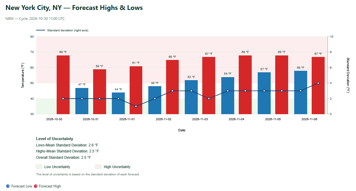
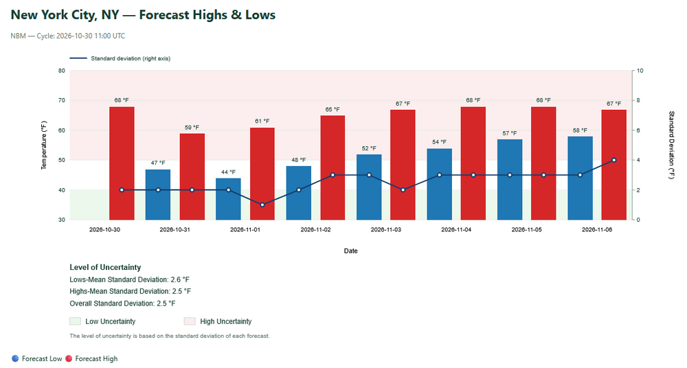
The latest NBM continues to show a mild start to November for the New York City area.
-
61.3/49 Tooooorch
-
Most of these winter outlooks are just guesses. Last year who had below normal temps for DEC-Feb and 50-60 inches of snow for us?!?!
-
It has been a near perfect foliage season. Even without any rain the ground isn't really drying out and, strangely, a few light freezes hasn't ended the growing season. I'm amazed at how healthy and deep green my front "lawn" is.
-
62 currently…gonna be gorgeous.
-
It really is ridiculous. That's literally 80% of our winters the past decade
-
temp over 60 now, where's the wind ?
-
Nonsense - he is predicting 10 - 40 inches total snowfall for Zone 4 ???? Why doesn't he just say he has no idea..................plus he seems so sure the early polar vortex disruption will be a short one and December will be a mild basically snowless month. He is one of the very few reputable METS online taking that chance before the vortex disruption even started........
-

E PA/NJ/DE Autumn 2026 Obs/Discussion
The Iceman replied to PhiEaglesfan712's topic in Philadelphia Region
I wouldn't be so sure of that, GFS has a cold bias in the long range. Several times it's show huge cold shots at the end of the run and so far it's just been can kicking. - Today
-
K3M7 - Lafayette TN KK61 - Beloit KS KHSR - Hot Springs SD KLIU - Littlefield TX KN66 - Oneonta NY PAAE - Ouzinkie AK PANO - Nondalton AK PFKK - Kokhanok AK
-

2026-2027 Record-breaking El Nino
soadforecasterx replied to Stormchaserchuck1's topic in Weather Forecasting and Discussion
Looks like the biggest one yet. Only right to have one last major push.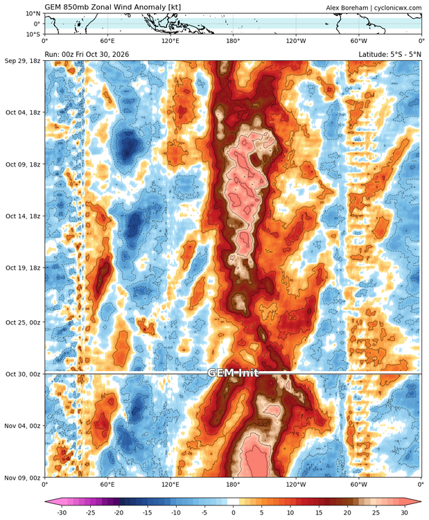
-
Already 56 here. TORCH!
-
Record latest freeze watch for MSP. November 18th is the date to beat.
-

2026-2027 Record-breaking El Nino
40/70 Benchmark replied to Stormchaserchuck1's topic in Weather Forecasting and Discussion
March could snap back... -
I can see 50"-80" from my house but will have to deal with only 20"-50"...
-
56° dewy and raining oak leaves
-
Central PA Autumn 2026
Mount Joy Snowman replied to canderson's topic in Upstate New York/Pennsylvania
Low of 50. A perfect ten today, whether that means the weather or your lady I’ll let up to you to decide. Happy Friday. -

2026-2027 Record-breaking El Nino
GaWx replied to Stormchaserchuck1's topic in Weather Forecasting and Discussion
Cosgrove for NE US: after a mild DJ is going for frigid Feb and cold Mar. -
Thank goodness the models will be coming out an hour earlier starting next week!