All Activity
- Past hour
-
Yooo this new plane just recorded 136 kt flight level wind...
-
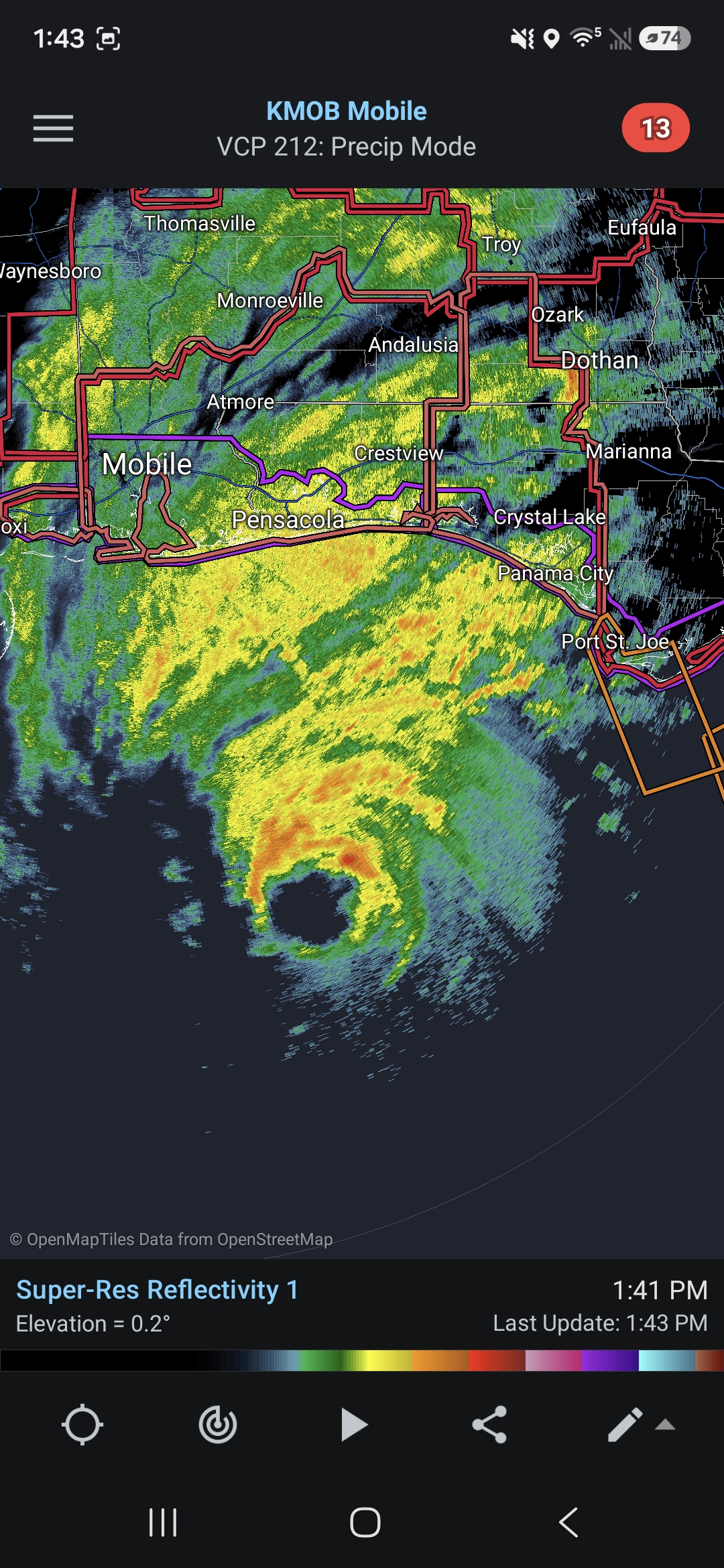
Noticeable uptick in both wind and rain in Wright FL (location below) over the past 30 minutes. .
-
When you do, make sure to invite @dendriteup to properly site it and set up adequate soil moisture sensors for you.
-
I disagree. They should postpone the AL/GA & GT/Duke U games
-

2026-2027 Fall/Winter Mountain Thread
GoAPPS replied to BlueRidgeFolklore's topic in Southeastern States
Excessive Rainfall Discussion NWS Weather Prediction Center College Park MD 104 PM EDT Fri Oct 9 2026 Day 2 Valid 12Z Sat Oct 10 2026 - 12Z Sun Oct 11 2026 ...THERE IS A MODERATE RISK OF EXCESSIVE RAINFALL FOR PORTIONS OF THE SOUTHEAST UNITED STATES... ...THERE IS A SLIGHT RISK OF EXCESSIVE RAINFALL FOR SOUTHEAST CALIFORNIA AND FAR SOUTHERN NEVADA... ...Southeast (Isaias)... ...1700Z Update... A Moderate Risk of Excessive Rainfall was introduced for portions of the western Carolinas southward into northern Georgia given latest QPF trends. Additional details will follow shortly. Bann Previous Forecast Discussion... The threat of heavy rainfall and flash flooding from Isaias will continue over a large portion of the Southeast on Saturday and Saturday Night. The latest outlook is very consistent with the previous forecast, with mostly small changes to account for the latest guidance and updated forecasts from NHC. See www.hurricanes.gov for the latest forecast information on all hazards associated with Isaias. Although the Slight Risk area is large, there are several areas of note where the threat is somewhat higher (on the high end of the 15 to 40 percent probabilistic range associated with that risk category), and could warrant an upgrade to a Moderate Risk in the future if guidance becomes more consistent and/or the potential for locally significant rainfall and flash flooding increases. 1. Convective rain band east of the center of Isaias (Florida Big Bend into much of Georgia). There is high confidence in a convective rain band setting up about 200 miles east of the track of the center of Isaias. This will ramp up Friday Night and likely be ongoing on Saturday morning. Given the access to moderate instability and precipitable water values approaching 2.5 inches, the rain rates could be intense at times (2-3 inches per hour). The key uncertainties are how far north the strongest convection will be able to reach, and how stationary the band will be overall. The 00Z HRRR suggested some northern limit to the extent of the instability due to a wedge of cooler air associated with a surface ridge and northeasterly low-level flow from the Piedmont of the Carolinas down into northern Georgia. However, other models suggest the effective warm front will lift further north and bring locations near Atlanta under risk of greater rain rates. This will be monitored for the need for a risk upgrade. 2. Southern Appalachians (far northeast Georgia, far upstate South Carolina, western North Carolina). Model QPF has been increasing in general in this region; for example, the NBM QPF in the upslope areas of western North Carolina has increased from a general 1-3 inches to 3-5 inches in the past 12 hours of updated runs. A contributing factor is the event coming into view of the hi-res model runs, of which many are showing more terrain enhancement and a wetter forecast, but there are some overall adjustments to the ensemble envelope with some trends in the overall forecast of Isaias. Not all hi-res models are suggestive of the highest rain rates reaching this region -- the 00Z HRRR kept instability suppressed further south with a wedge of cooler air in place closer to the mountains. However, other hi-res models are beginning to suggest double digit totals are not out of the question depending on the mesoscale details (particularly strength and orientation of the low-mid level flow and available instability). It is noted here that a Moderate Risk upgrade was strongly considered, but after collaboration with WFO GSP and the uncertainties described here, it was held at a high-end Slight Risk for now. Continued model trends in a wetter direction and reduction in rainfall uncertainty would likely drive an upgrade later today. ... -
Final Call for Major Hurricane Isaias...no changes in track, but slightly stronger. Landfall near Destin, FL at 11PM tonight with maximum sustained winds of 105MPH and maximum storm surge of around 10' in the vicinity of Choctawhatchee Bay, FL. https://forecastmaven.com/forecasts/easternmassweather/final-call-for-dangerous-major-hurricane-isaias-approach-to-fl-panhandle/ Isaias Final Call:
-
Latest Euro. Flash flood threat ramps up tomorrow evening.
.thumb.png.43305a076a62145dd3b92d5cb354aa2d.png)
-
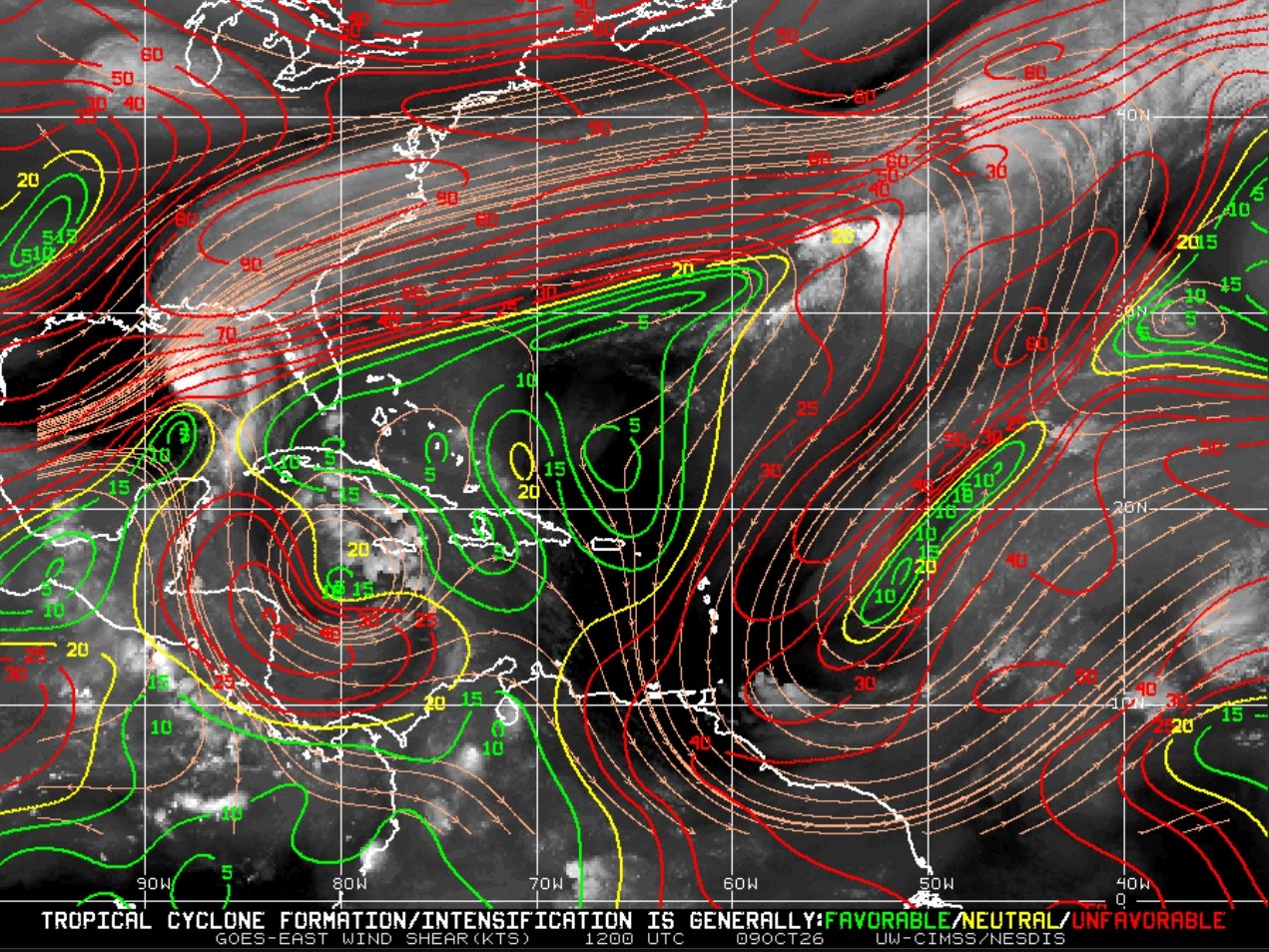
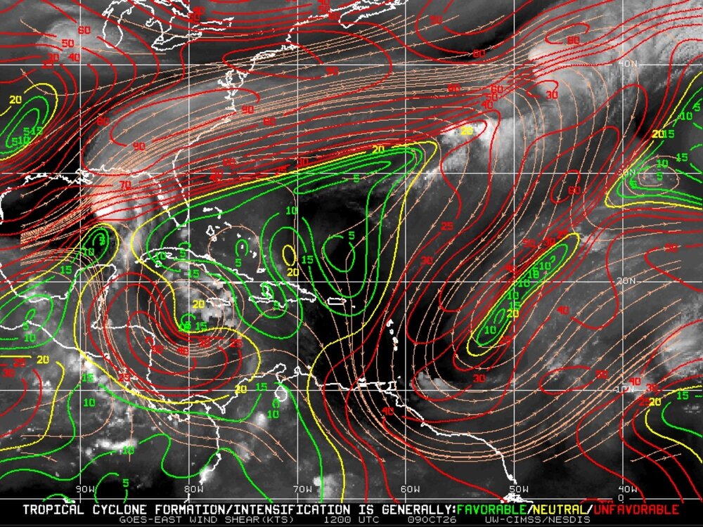
That… is actually impressive. Against 40 kts of shear
-
Rachel Local Watch/Warning Statement/Advisory Number 50 National Weather Service San Diego CA EP182026 759 AM PDT Fri Oct 9 2026 CAZ050-092300- /O.NEW.KSGX.TR.A.2018.261009T1459Z-000000T0000Z/ San Diego County Valleys- 759 AM PDT Fri Oct 9 2026 ...TROPICAL STORM WATCH IN EFFECT... A Tropical Storm Watch means tropical storm-force winds are possible somewhere within this area within the next 48 hours * LOCATIONS AFFECTED - Escondido - El Cajon - Lakeside - Poway * WIND - LATEST LOCAL FORECAST: Below tropical storm force wind - Peak Wind Forecast: 10-15 mph with gusts to 30 mph - THREAT TO LIFE AND PROPERTY THAT INCLUDES TYPICAL FORECAST UNCERTAINTY IN TRACK, SIZE AND INTENSITY: Potential for wind 39 to 57 mph - PLAN: Plan for hazardous wind of equivalent tropical storm force. - PREPARE: Efforts to protect property should now be underway. Prepare for limited wind damage. - ACT: Act now to complete preparations before the wind becomes hazardous. - POTENTIAL IMPACTS: Limited - Damage to porches, awnings, carports, sheds, and unanchored mobile homes. Unsecured lightweight objects blown about. - Many large tree limbs broken off. A few trees snapped or uprooted, but with greater numbers in places where trees are shallow rooted, especially in coastal and valley locations that don`t typically experience strong winds. Some fences and roadway signs blown over. - A few roads impassable from debris, particularly within urban or heavily wooded places. Hazardous driving conditions on bridges and other elevated roadways. - Scattered power and communications outages. * FLOODING RAIN - LATEST LOCAL FORECAST: - Peak Rainfall Amounts: around 1 inch - THREAT TO LIFE AND PROPERTY THAT INCLUDES TYPICAL FORECAST UNCERTAINTY IN TRACK, SIZE AND INTENSITY: Potential for moderate flooding rain - PLAN: Emergency plans should include the potential for moderate flooding from heavy rain. Evacuations and rescues are possible. - PREPARE: Consider protective actions if you are in an area vulnerable to flooding. - ACT: Heed any flood watches and warnings. Failure to take action may result in serious injury or loss of life. - POTENTIAL IMPACTS: Significant - Heavy rainfall flooding may prompt several evacuations and rescues, especially in and below recently burned areas. - Rivers may quickly become swollen with swifter currents and overspill their banks in a few places, especially in usually vulnerable spots. Small streams, creeks, arroyos, and ditches overflow. - Flood waters can enter some structures or weaken foundations. Several places may experience expanded areas of rapid inundation at underpasses, low-lying spots, and poor drainage areas. Some streets and parking lots take on moving water as storm drains overflow. Driving conditions become hazardous. Some road closures. * TORNADO - LATEST LOCAL FORECAST: - Situation is unfavorable for tornadoes - THREAT TO LIFE AND PROPERTY THAT INCLUDES TYPICAL FORECAST UNCERTAINTY IN TRACK, SIZE AND INTENSITY: Tornadoes not expected - PLAN: Tornadoes are not expected. Showers and thunderstorms with gusty winds may still occur. - PREPARE: Little to no preparations needed to protect against tornadoes at this time. Keep informed of the latest tornado situation. - ACT: Listen for changes in the forecast. - POTENTIAL IMPACTS: Little to None - Little to no potential impacts from tornadoes. * FOR MORE INFORMATION: - sdcountyemergency.com
-
Oh
-
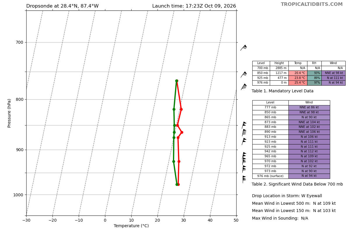
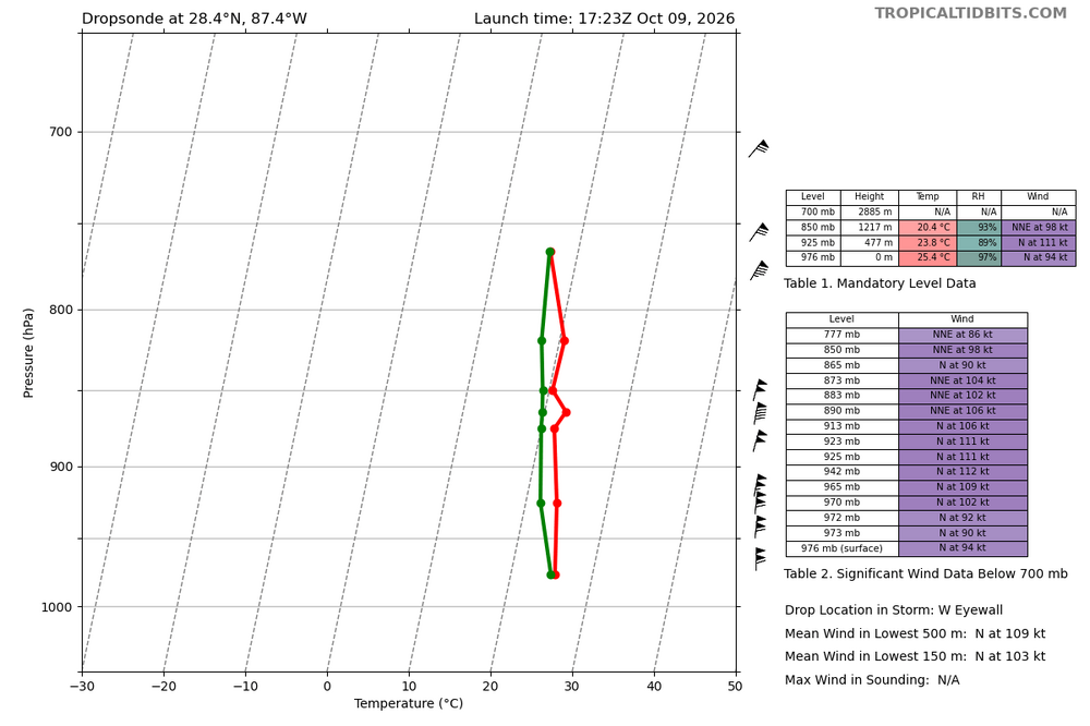
110 mph surface winds in the west eyewall
-
 It's a little dot, but +12c has appeared in the subsurface on TAO/Triton for the first time ever. That's +22F, 58f would be 80f.
 -
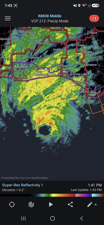
So resilient
-
-
I think it stuck because it transitioned into a nor’easter while it was over us.
-
Tropical Storm Rachel Discussion Number 50 NWS National Hurricane Center Miami FL EP182026 800 AM PDT Fri Oct 09 2026 Satellite images indicate that Rachel is struggling to maintain deep convection, with only limited and shallow convection remaining near the center of circulation. A scatterometer pass received shortly after the previous advisory indicated peak winds of around 43 kt. Satellite intensity estimates from UW-CIMSS range from 31 to 44 kt, while the TAFB subjective Dvorak estimate is T2.5/35 kt. Given the scatterometer data, the initial intensity is held at 45 kt for this advisory. The storm is moving northeastward at an estimated 055/4 kt. A deepening mid-to upper-level trough moving into the eastern Pacific toward the western United States is expected to steer Rachel northeastward to north-northeastward with an increasing forward speed throughout the forecast period. On the forecast track, the system is expected to move inland over northern Baja California late Saturday or early Sunday before continuing northeastward into the southwestern United States on Sunday. There has been a northward shift in the latest track guidance, with the global and hurricane regional models now bringing the center near the U.S./Mexico border or into extreme southern California. The latest NHC track forecast has been nudged northward and lies between the global and regional hurricane models to the left, and the HCCA and GDMI slightly to the right. Given this track forecast, Tropical Storm Watches have been issued for portions of northern Baja California and southern California. There will be a sharp gradient in the wind field, with the strongest winds anticipated to remain primarily in the eastern and southern semicircles of the circulation. Rachel remains embedded within a very dry air mass, with mid-level relative humidity values in the lower 30 percent range. Sea surface temperatures of around 24-25C will also limit convective organization. However, interaction with the aforementioned deepening trough is expected to increase mid-level moisture and improve upper-level divergence, allowing Rachel to produce intermittent bursts of deep convection and maintain tropical cyclone status. Furthermore, there are anomalously warm waters just offshore of northern Baja California for this time of year, running roughly 6-7C above normal. There has been a notable upward trend in the intensity guidance from the global and regional models this cycle, and the NHC forecast has been adjusted accordingly. As the system approaches the coast, increasing vertical wind shear is expected to displace the remaining convection downshear toward the northeastern portion of the circulation. Rachel is forecast to remain a strong tropical storm as it makes landfall. Once inland, rapid weakening is expected, and the system is forecast to become post-tropical over the southwestern United States. The latest NHC intensity forecast lies near the upper end of the guidance envelope, reflecting the complex interactions between Rachel and the approaching trough, as well as the inherent uncertainty in how models handle these processes. Key Messages: 1. Rachel is expected to approach the coast of the northern Baja California Peninsula and southern California at tropical storm strength Saturday night, and a Tropical Storm Watch is now in effect from San Jose de Las Palomas, Mexico northward into southern California to the San Diego/Orange County Line. 2. Damaging wind gusts associated with Rachel and its remnants are expected to spread over portions of northwestern Mexico and interior portions of the Southwest United States, especially in areas of higher terrain, Saturday night and Sunday. 3. Rachel and the moisture associated with the system will spread over portions of the Southwest United States and northern Baja California peninsula through this weekend. This will lead to increasing coverage of rainfall and for the potential of flash and urban flooding. 4. Swells partly generated by Rachel will continue to build along the coast of Southern California and northern Baja California. These swells are likely to cause life-threatening surf and rip current conditions, as well as moderate to isolated major coastal flooding, through early next week. Please consult products from your local weather office. FORECAST POSITIONS AND MAX WINDS INIT 09/1500Z 22.8N 124.6W 45 KT 50 MPH 12H 10/0000Z 23.4N 123.6W 45 KT 50 MPH 24H 10/1200Z 25.1N 121.0W 50 KT 60 MPH 36H 11/0000Z 28.5N 118.1W 55 KT 65 MPH 48H 11/1200Z 33.3N 116.0W 45 KT 50 MPH...INLAND 60H 12/0000Z 38.1N 114.0W 35 KT 40 MPH...POST-TROP/INLAND 72H 12/1200Z...DISSIPATED $$ Forecaster Kelly
-
BULLETIN Tropical Storm Rachel Advisory Number 50 NWS National Hurricane Center Miami FL EP182026 800 AM PDT Fri Oct 09 2026 ...TROPICAL STORM WATCHES ISSUED FOR SOUTHERN CALIFORNIA AND BAJA CALIFORNIA... SUMMARY OF 800 AM PDT...1500 UTC...INFORMATION ---------------------------------------------- LOCATION...22.8N 124.6W ABOUT 935 MI...1505 KM W OF THE SOUTHERN TIP OF BAJA CALIFORNIA ABOUT 820 MI...1325 KM SW OF SAN DIEGO CALIFORNIA MAXIMUM SUSTAINED WINDS...50 MPH...85 KM/H PRESENT MOVEMENT...NE OR 55 DEGREES AT 5 MPH...7 KM/H MINIMUM CENTRAL PRESSURE...994 MB...29.36 INCHES WATCHES AND WARNINGS -------------------- CHANGES WITH THIS ADVISORY: A Tropical Storm Watch has been issued for the southern California coast from the U.S/Mexico Border northward to the San Diego/Orange County Line. The government of Mexico has issued a Tropical Storm Watch along the west coast of Baja California, from San Jose de Las Palomas northward to the U.S./Mexico Border and, the east coast of Baja California, from Isla San Luis northward to Puerto Penasco. SUMMARY OF WATCHES AND WARNINGS IN EFFECT: A Tropical Storm Watch is in effect for... * Southern California coast from the U.S/Mexico Border northward to the San Diego/Orange County Line * West coast of Baja California, from San Jose de Las Palomas northward to the U.S./Mexico Border * East coast of Baja California, from Isla San Luis northward to Puerto Penasco A Tropical Storm Watch means that tropical storm conditions are possible within the watch area, generally within 48 hours. Interests in northern Baja California, northern Gulf of California, and Southern California should continue to monitor the progress of Rachel.
-
2026-2027 Fall/Winter Mountain Thread
strongwxnc replied to BlueRidgeFolklore's topic in Southeastern States
NWSGSP I have an account via the school system I work for. I only ever connect during weather events. -
If anyone is looking to purchase a Wachusett season pass and wants to save $10, send me a message
-
San Diego under a Tropical Storm Watch
-

2026-2027 Fall/Winter Mountain Thread
wncsnow replied to BlueRidgeFolklore's topic in Southeastern States
It's hard to believe we aren't even under a flood watch. -
FWIW, multiple hurricane/AI model runs have had it as a borderline category 4 right now for a few days. Big W for those suites.
-
 no prescription pharmacy paypal: Seroquel - no prescription needed pharmacy
 -
The Nokia 3310 of hurricanes
-

2026-2027 Fall/Winter Mountain Thread
Maggie Valley Steve replied to BlueRidgeFolklore's topic in Southeastern States
I was part of NWS chat for many years at HGX before moving up here. Keep us posted.






.png.48f27c9dd636c07b1713cabd8a006b17.png)