All Activity
- Past hour
-

Central PA Summer 2026 Discussion/Obs Thread
mahantango#1 replied to Voyager's topic in Upstate New York/Pennsylvania
Zilch here. -
.thumb.jpg.6a4895b2a43f87359e4e7d04a6fa0d14.jpg)
Central PA Summer 2026 Discussion/Obs Thread
Yardstickgozinya replied to Voyager's topic in Upstate New York/Pennsylvania
Certainly, can't rule out, you're seeing more storms this morning but either way, it looks like you'll see some sun.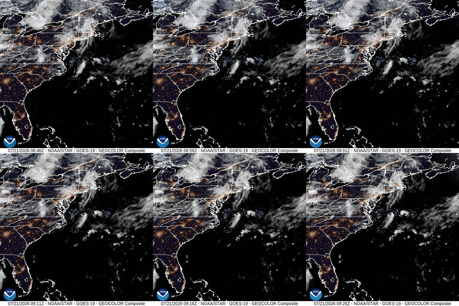
-

Chester County PA - Analytical Battle of Actual vs. Altered Climate Data
chubbs replied to ChescoWx's topic in Climate Change
Repeating what I said above garbage in, garbage out. Your analysis and AI's conclusion is faulty. You aren't telling AI that the Chesco COOPs are included in the SE PA climate division. You can't conclude that Chester County is the same as the non-Chesco stations if you include Chester County with the other stations. Second the regression slopes depend on the end-date. You need to include enough years before and after the moves for the station moves to be fully reflected in the regression. For the period 1941-1975 I get a much bigger difference in slopes -.69 for Chesco and only -.32 for the Division. Excluding Chester County from the Division would lower the Division slope further. Finally AI already has a Pvalue of 0.057, i.e, there is a 94% chance that Chesco is different using your faulty comparisons. Correct the errors and the Pvalue will shrink considerably. However I don't need stats, the chart clearly shows that Chesco COOPS cool vs the SEPA Climate Div.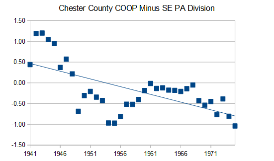
-
 Temp down to 54F this am; looks like storms already firing in PA/NJ border. Congrats W CT?
 -
Central PA Summer 2026 Discussion/Obs Thread
Yardstickgozinya replied to Voyager's topic in Upstate New York/Pennsylvania
. What's your experiencing should lift north with the warm front , it looks like we're gonna bake off nicely in the warm sector today.
-
-

Central PA Summer 2026 Discussion/Obs Thread
Voyager replied to Voyager's topic in Upstate New York/Pennsylvania
Outside with my second coffee and smoke, and she's flashing and booming a bit now. And as I type this the rain is getting heavy again. These morning storms seem to be training right up through Schuylkill County. - Today
-
Central PA Summer 2026 Discussion/Obs Thread
Yardstickgozinya replied to Voyager's topic in Upstate New York/Pennsylvania
I saw some lighting and heard some thunder from a distance but no rain here . It started as a little blip near Carlisle and became a nice little cluster relatively quickly. Very fast NE motion on those storms already with another weak echo, blazing, due west across the mason dixon. It already seems like there's going to be some ugly stuff around today. -
Central PA Summer 2026 Discussion/Obs Thread
Voyager replied to Voyager's topic in Upstate New York/Pennsylvania
Yeah. No thunder, but heavy rain. Woke me up at 4:30AM and already got 0.36" -
Central PA Summer 2026 Discussion/Obs Thread
Yardstickgozinya replied to Voyager's topic in Upstate New York/Pennsylvania
Right now lol. -
As of 121am Texas time July 21, Bertha is disorganized. Most of the precip is south of the center of circulation. This puppy needs to be monitored. With any luck she will reach hurricane status and continue lumbering slowly westward toward Texas where I hope she will move in and take up a happy productive residence swirling around for a week about 40-50 miles southwest of Buda. We are parched and need more rain. I'd love it if Bertha would please spin me up some highly efficient tropical rainbands then train them right over the Austin/Buda Corridor for days on end. I'd love to see the Plum Creek rise right over Rt 1626 and 967. I'd walk down there with my old snow ruler and take water level readings, while blasting the latest Gen Z tracks on my headphones! Another thing I crave for is to get so much heavy efficient tropical rain, that all the water storage facilities scattered all over Buda and Kyle would get filled right to the brim, even overflowing and running down the streets! I'd definitely enjoy a truly EPIC jebwalk!
-
 TheraCore Pharmacy: TheraCore Pharmacy - canine prednisone 5mg no prescription
 -
TheraCore Pharmacy: TheraCore Pharmacy - canine prednisone 5mg no prescription
-
Looking at another MCS rolling in during the next few hours, ugh!!! Every single storm is between 11pm and 8am (nearly all from 12am-3am) this year, just why? I haven't hit the pillow yet and soon my block will be off it again.
-
I'm not sure there will be much left to track after about 60-72 hr as the entire circulation gets sheared apart. HAFS-A/B do have any coherent sfc center by 72 hr. You can see the deformation pulling it apart well at 850, 700, and 500 on the ECMWF RH/streamline fields. NHC showing a trackable center from their 03z advisory at 96 and 120 hr seems optimistic IMHO.
-
0Z UKMET: significantly stronger than last few runs and not as far N track allowing it to avoid LA for the most part and actually landfall just S of Galveston as TS, where Joe Bastardi said he may be hanging out: GLOBAL MODEL DATA TIME 0000UTC 21.07.2026 TROPICAL STORM BERTHA ANALYSED POSITION : 28.5N 86.2W ATCF IDENTIFIER : AL022026 LEAD CENTRAL MAXIMUM WIND VERIFYING TIME TIME POSITION PRESSURE (MB) SPEED (KNOTS) -------------- ---- -------- ------------- ------------- 0000UTC 21.07.2026 0 28.5N 86.2W 1005 32 1200UTC 21.07.2026 12 28.7N 86.4W 1001 42 0000UTC 22.07.2026 24 29.3N 87.1W 1001 37 1200UTC 22.07.2026 36 29.4N 87.6W 1002 37 0000UTC 23.07.2026 48 28.9N 89.0W 1002 42 1200UTC 23.07.2026 60 29.0N 90.3W 1004 37 0000UTC 24.07.2026 72 28.5N 92.6W 1000 40 1200UTC 24.07.2026 84 29.1N 94.9W 1006 38 0000UTC 25.07.2026 96 CEASED TRACKING
-
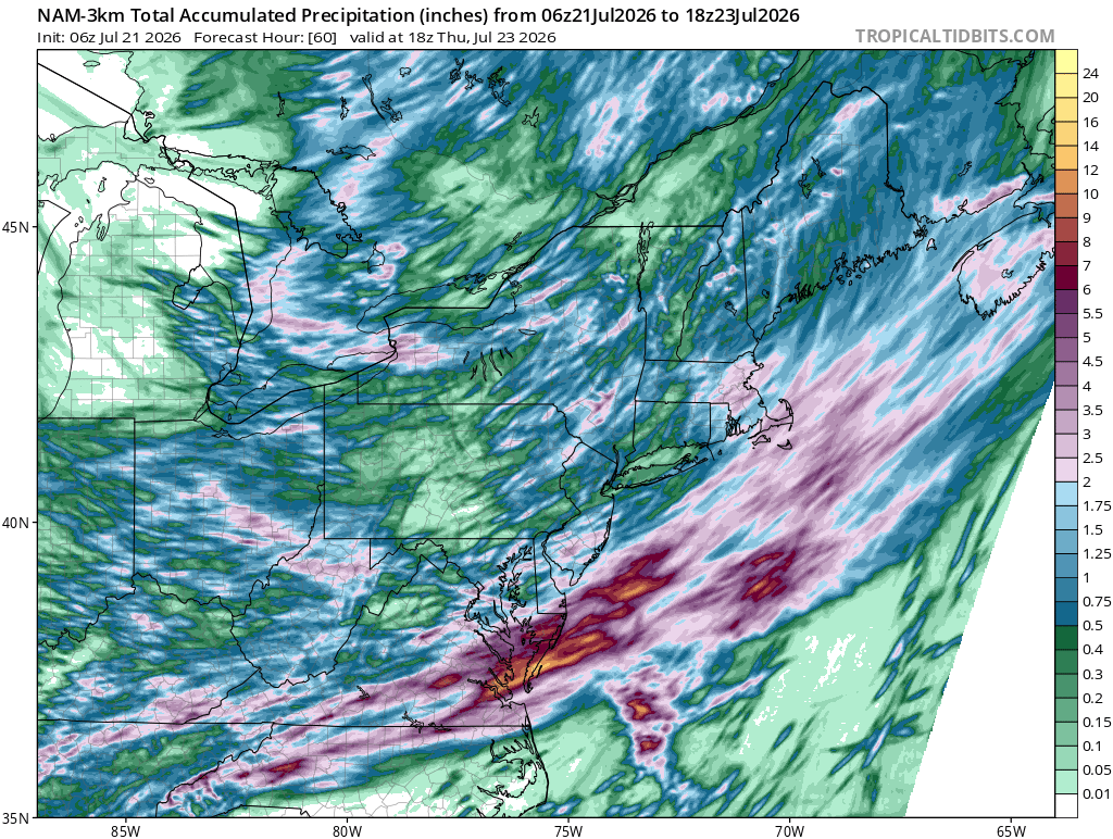
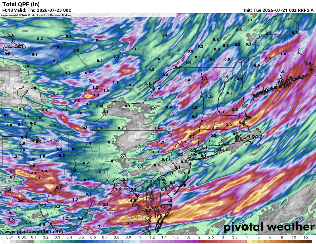
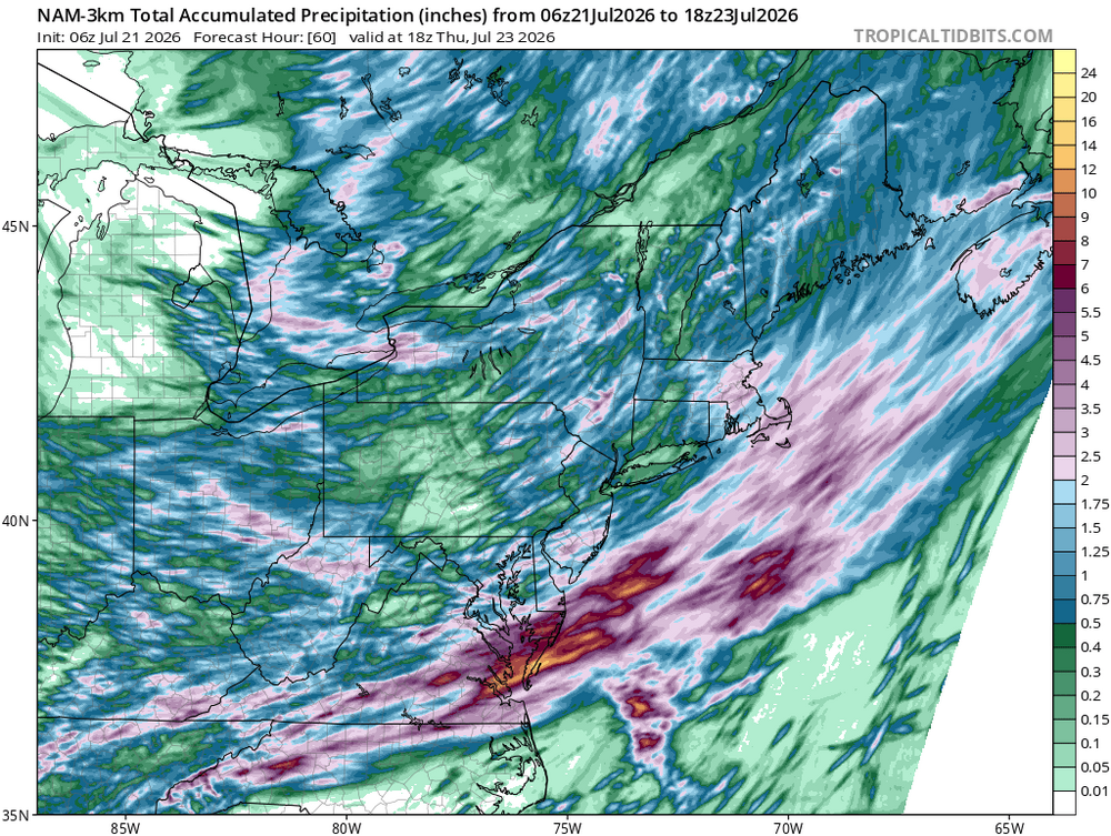
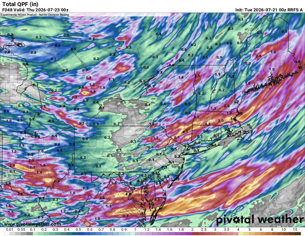
 00z HRRR and esp. RRFS go big w/ the QPF Tue and Wed. Sern NY bulls-eye again! Tor risk wrn sections today and entire area in MRGL Wed. Quite the 500 trough for July to impact the region and it just doesn't quickly swing through. Train echo tstms likely. And hardly any talk here? Wxwiz, I am disappointed! CoastalWx probably "MEH!" And work more on this drought. You'd think its so bad from the MSM when VT has no drought, much of NH nothing, and the same for ME. Since the start of the year, the DSCI has dropped from 137 to 70 for the Northeast and Mid-Atlantic, but do you ever hear about that? "Oh, but ern MA is in severe drought!" Local drought is not the same as widespread drought.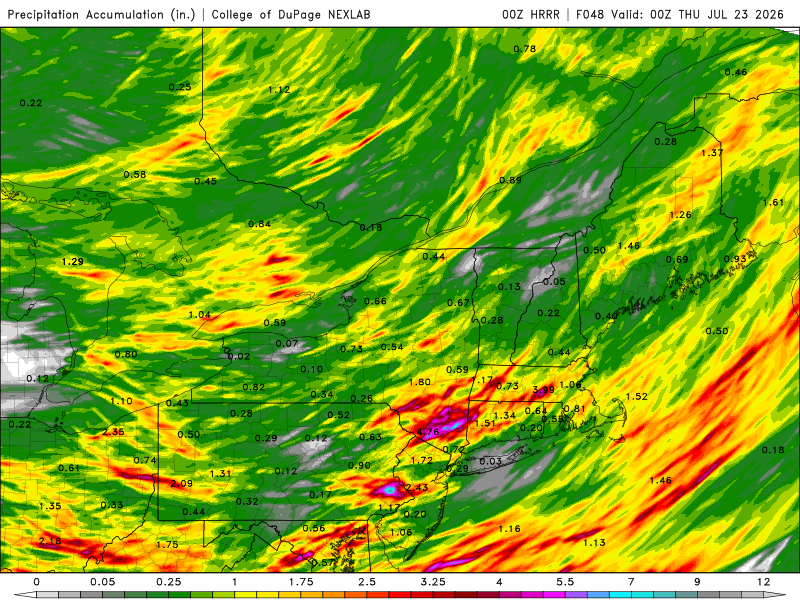
-
Now it shifted to tomorrow
-
I also didn't realize Edison renamed themselves Newark
-
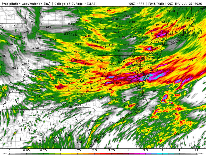
Wow. You get the classic "discrete cells ahead of line" which you always have to watch closely for tor potential, then big clusters w/ training psbl and FF threat. And now much of the DMV could do well on Wed as the front gets hung up w/ more training and FF threat. The 00z HRRR is really big for QPF. 48 hr totals 5" max just NW of DC and a whopping nearly 12" max near WAL! Well, we do need the rain. 00z RRFS is very similar to the HRRR for big QPF w/ the 5" max just S of DC and an 11" max near WAL. Winds aloft look better than the last event for svr wx. I esp. like the 250 mb speed max approaching late in the afternoon, so discrete supercells should sustain better. Tor threat is there but not high-end.
- 1,205 replies
-
- 3
-

-
- severe
- thunderstorms
- (and 7 more)
-
Which is obviously wrong. It continues to appear that there will be a smaller round for late morning and midday, and then the potential major round for early evening. We could get hit hard around 5 to 7pm, but we'll have to see if there's enough sunshine during the afternoon break to really fire up the atmosphere and increase the risk of the early evening storms being severe.
-
Another 4-5" rain event just north of Des Moines today. That area has been hammered this summer. Somewhere in that area has probably had 20+ inches of rain in the past two months.
-
Solid hit today. 1.56". Could have had more except for some untimely swerves. 3.77" MTD.
-
Tropical Storm Bertha Advisory Number 7 NWS National Hurricane Center Miami FL AL022026 1000 PM CDT Mon Jul 20 2026 ...TROPICAL STORM WARNING ISSUED FOR A PORTION OF THE NORTHERN GULF COAST... SUMMARY OF 1000 PM CDT...0300 UTC...INFORMATION ----------------------------------------------- LOCATION...28.2N 85.9W ABOUT 140 MI...225 KM S OF PANAMA CITY FLORIDA ABOUT 215 MI...350 KM SE OF MOBILE ALABAMA MAXIMUM SUSTAINED WINDS...40 MPH...65 KM/H PRESENT MOVEMENT...STATIONARY MINIMUM CENTRAL PRESSURE...999 MB...29.50 INCHES Tropical Storm Bertha Discussion Number 7 NWS National Hurricane Center Miami FL AL022026 1000 PM CDT Mon Jul 20 2026 The system has become a little better organized with an area of deep convection over the southern semicircle showing slight curvature and limited curved convective bands over the northwestern quadrant. Flight-level winds from both NOAA and Air Force Hurricane Hunter aircraft within the convection to the southwest and southeast of the center indicate that the intensity is near 35 kt, so the system has been upgraded to Tropical Storm Bertha. The aircraft also reported that the central pressure has dropped about 6 mb since this afternoon. The storm has well-defined upper-level outflow to the south and southwest, but outflow is limited over the northern semicircle. There have been several center fixes from the aircraft which indicate very slow, erratic motion. Since the storm has moved very little overall this evening, the best estimate for the initial motion is nearly stationary. Bertha remains sandwiched between two mid-level subtropical high cells, in a region of weak steering currents. The high to the northwest of the storm is forecast to become the dominant steering influence which should induce a west-northwestward or westward motion over the next few days. The official track forecast is similar to the previous NHC prediction, on the southern side of the guidance suite and close to the Google DeepMind ensemble mean. Bertha is being affected by significant north-northeasterly vertical wind shear. Dynamical guidance indicates that this shear will increase during the next couple of days. This should limit intensification of the storm before the center reaches the coast. Simulated satellite imagery from the global models shows the deep convection near or offshore of the coastline, likely due to the shear. Unfavorable atmospheric conditions along with the interaction of land should prevent strengthening late in the forecast period. The official intensity forecast is on the high side of the model guidance. FORECAST POSITIONS AND MAX WINDS INIT 21/0300Z 28.2N 85.9W 35 KT 40 MPH 12H 21/1200Z 28.8N 86.6W 40 KT 45 MPH 24H 22/0000Z 29.1N 87.3W 45 KT 50 MPH 36H 22/1200Z 29.3N 88.1W 45 KT 50 MPH 48H 23/0000Z 29.3N 89.4W 40 KT 45 MPH...INLAND 60H 23/1200Z 29.3N 90.7W 35 KT 40 MPH...INLAND 72H 24/0000Z 29.3N 92.1W 30 KT 35 MPH...OVER WATER 96H 25/0000Z 29.3N 94.6W 25 KT 30 MPH...OVER WATER 120H 26/0000Z 29.3N 97.0W 20 KT 25 MPH...POST-TROPICAL $$ Forecaster Pasch
-
 He could be deep in the Allagash forests and still get the Trump signal here