All Activity
- Past hour
-
Happy birthday @H2O
-
I know exactly what you mean! Grew up in PTC right near FFC and recently moved back, settling in western Fayetteville. I remember watching storms on TWC radar (because we had no internet back then, local on the 8s was it!) and it would split, or evaporate and reform on the other side. I called it the "Fayette wedge". At least we got to go to the pool yesterday for the first day it was open, and I got really lucky leaving work early enough to come down the connector before any rain fell.
-
Still warm and muggy. Where's the front??
-
Saturday cool and cloudy CT. Sunday into Monday ass. Maybe better western NE monday. Weekend Meh.
-
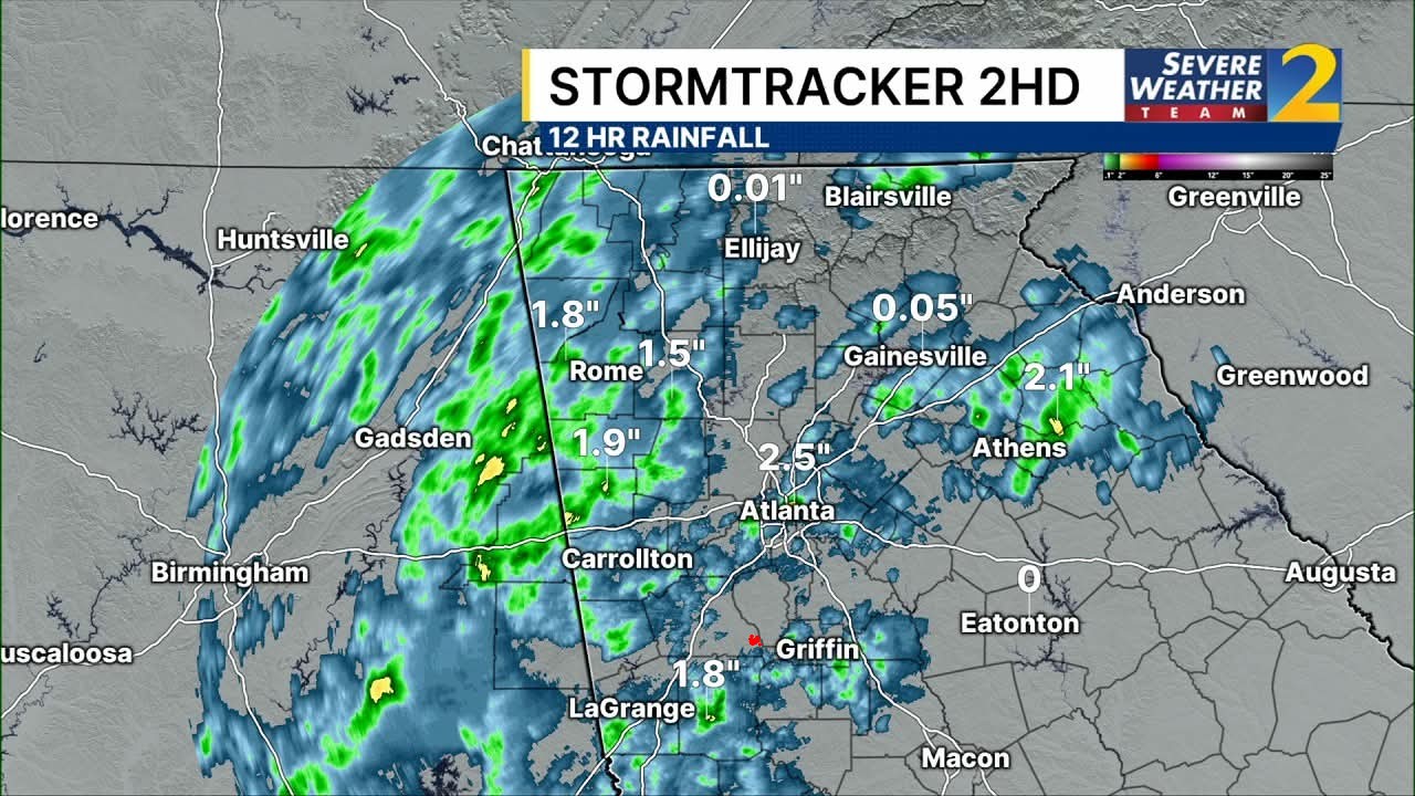
I'm the red dot on the map....yup. Happens quite often. I mean I would think in the next week I will get one storm. Maybe?

-
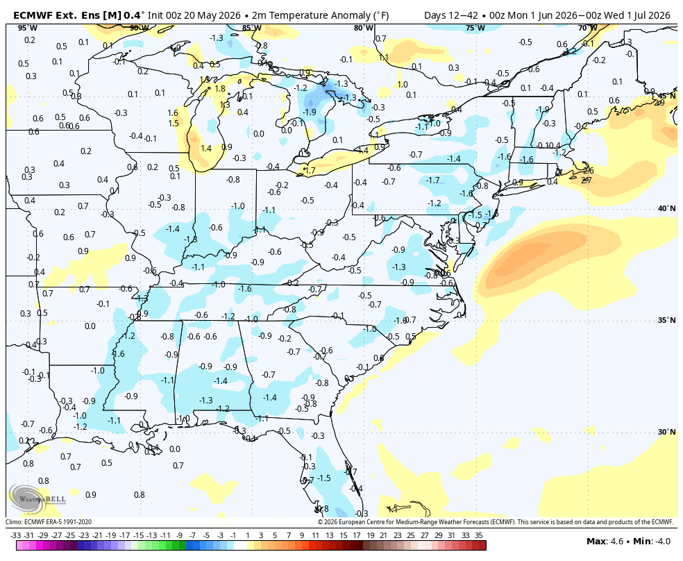
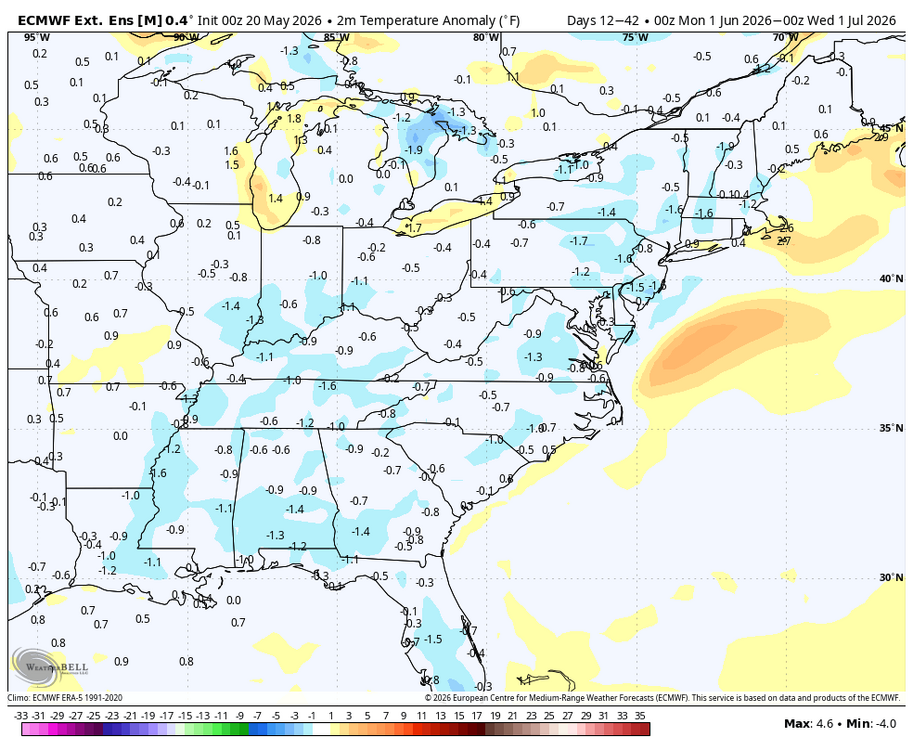
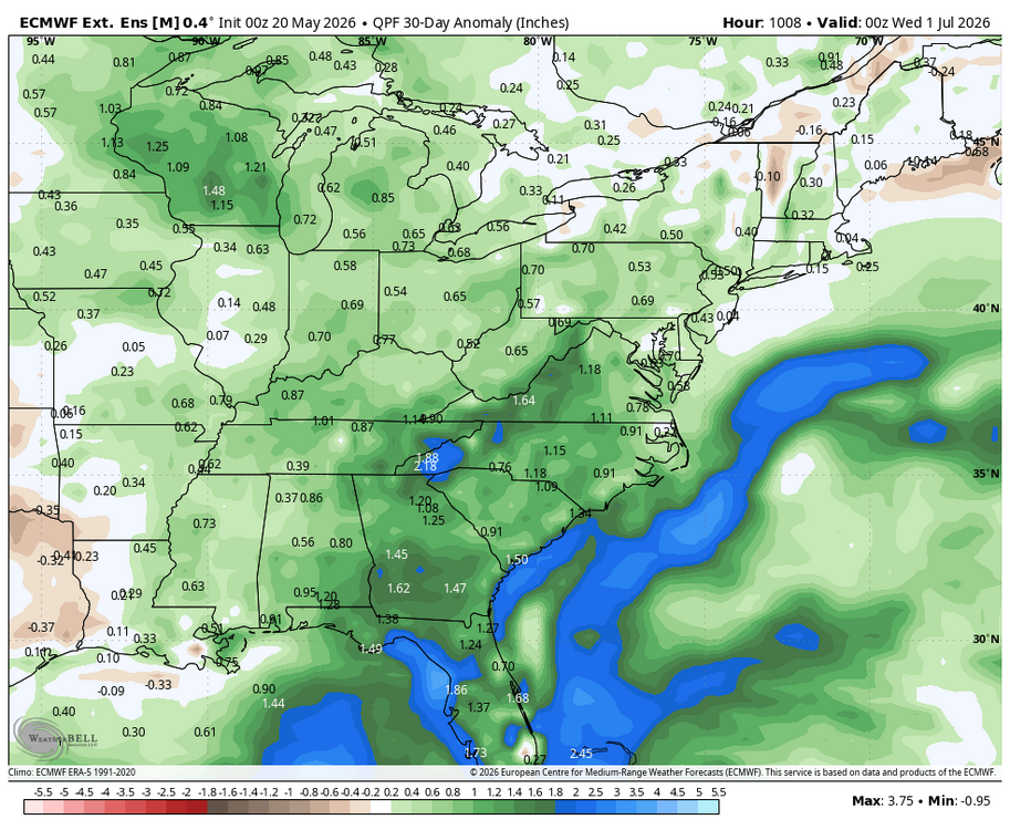
WB latest EURO weeklies for June.
-
.08" here as well, might add a hundredth or two this morning
-
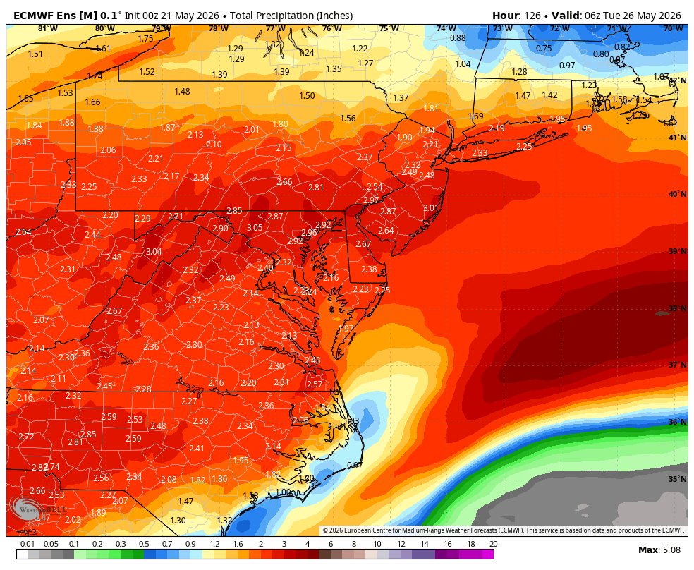
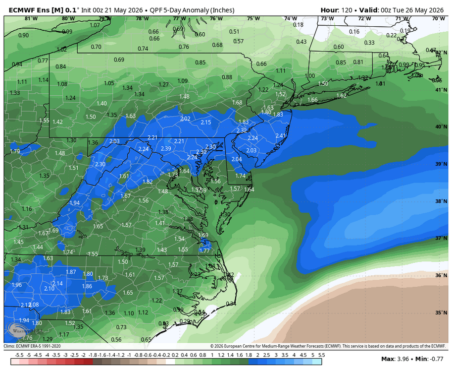
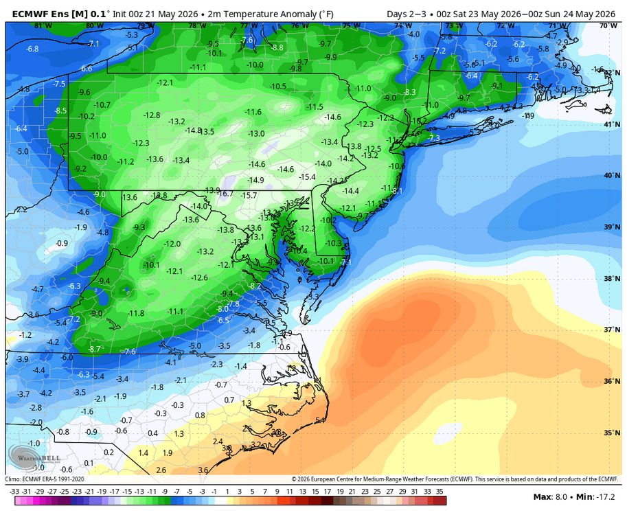
WB 0Z EURO. Rain over the next 5 days. Looks like most of this falls through Saturday. Right now Sunday and Monday look like just light showers. Saturday will be chilliest.

-
Bring on the rain! We missed out on last nights event. Looks like some solidly below average temps the next 5 days or so; unfortunate that it’s over Memorial Day weekend.
-
Just one bad day. Two out of three ain’t bad. Guidance is slowly coming into better agreement on the weather for the upcoming holiday weekend. While we continue to forecast a cooler than normal weekend with wet weather, the full three day weekend shouldn`t be a washout. As it stands now, surface high pressure will be fighting to keep low pressure from the OH valley and its associated wet weather at bay as long as possible; this means the earlier in the day on Saturday the better chance we stay dry, it could even hold out for a fully dry Saturday, especially toward northeast/north central MA. Eventually the shortwave and wet weather move over SNE Saturday night/Sunday and this looks to be the most likely "washout" day before the low moves east of MA by Monday with drier air funneling in and making for a more pleasant day than Sunday. Sunday will also be breezy as a 25-35kt LLJ moves overhead. Temperatures bottom out on Sunday with highs in the upper 50s, warming into the upper 60s and 70s by Monday.
-
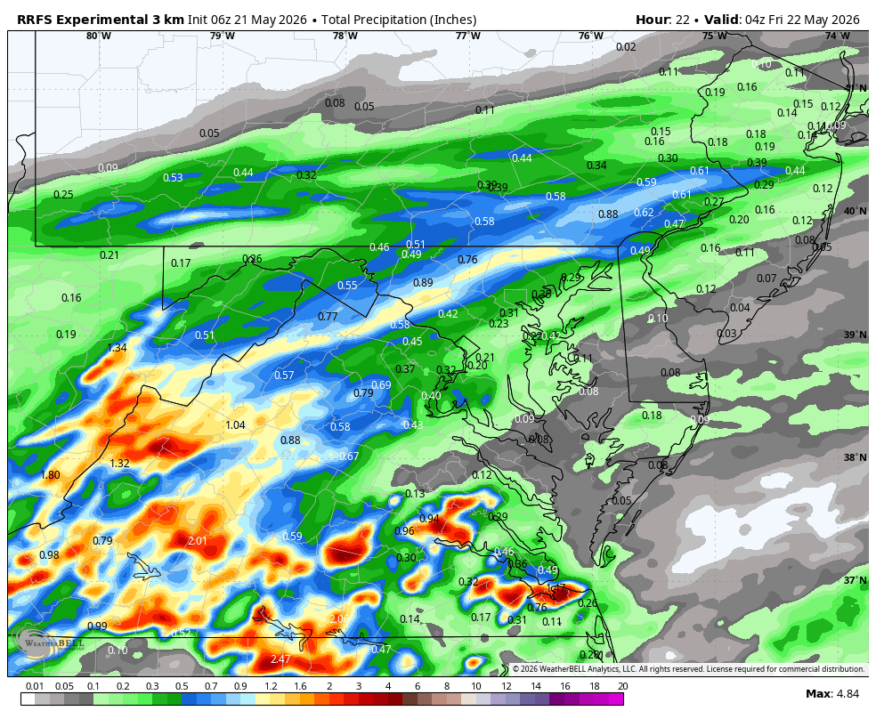
WB 6Z RRFS for today. (did a nice job forecasting yesterday's precip. totals)

-
.72 yesterday hoping for several good soakings as im going out if town next week and would love to not have to water the garden
-
0.65” fell thru early Wednesday evening imby/Columbia.
-

Chester County PA - Analytical Battle of Actual vs. Altered Climate Data
chubbs replied to ChescoWx's topic in Climate Change
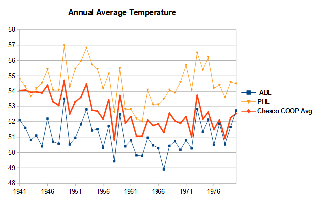
Your amateur "facts and math" are distorting the raw data by not accounting for the large changes in the Chesco station network with time. In 1941 all the Chester County COOP stations were much warmer than the county average. Phoenixville was had excessive 95+F days vs other local stations; while, both Coatesville and West Chester were located in built up areas. By not accounting for station location you have Chester County's past way too warm, as warm as the Philly Airport in 1941-45 on your chart. All 3 Chesco stations experienced cooling moves after WWII: Coatesville in 1946 and 48, Phoenixville in 1948 and West Chester in 1970. Your simple “math” is incorporating these station moves into our weather. The chart below covers the Coatesville and Phoenixville moves after WWII. The station moves are easy to spot because they occurred at different times. Between 1945 and 1949 both Coatesville and Phoenixville cooled by 2F vs West Chester and other local stations. Note that the Philadelphia Airport matched West Chester and other local stations over this period. The problematic data is in Chester County not the Philadelphia Airport. The final chart shows the Chesco Coop average vs Philadelphia and Allentown over the 1940-70 station move period. The Chesco Coops started as warm as Philadelphia in 1941, but ended as cool as Allentown by 1970. Meanwhile the Philly Airport matches Allentown and all of the other Mt Holly climate sites. The raw data clearly shows that the difference between Philly and Chesco in your chart is due to station changes in the Chester County Coops. There is no evidence to support your airport heat island claim. You have jumped to the wrong conclusion by cherry-picking your "facts". Using a broader range of data from outside of Chester County, shows that the Chester County COOPs and your simple “math” is where the problem lays.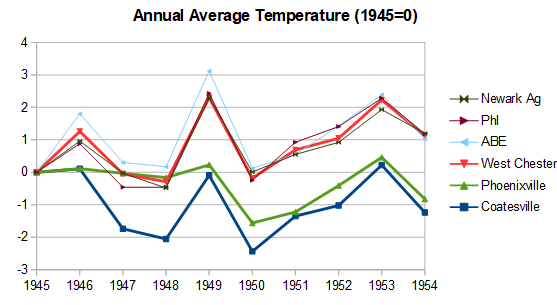
-
HIghs ACY: 97 BLM: 96 EWR: 96 TEB: 96 LGA: 96 New Brnswck: 95 PHL: 95 ISP: 93 JFK: 93 TTN: 93 NYC: 92
-
Weekend gone. Maybe Saturday salvaged especially north and east. We knew.
- Today
-
Off by 15 miles. Maybe your well will run dry?
-
HIghs ACY: 97 BLM: 96 EWR: 96 TEB: 96 LGA: 96 New Brnswck: 95 PHL: 95 ISP: 93 JFK: 93 TTN: 93 NYC: 92
-

Central PA Spring 2026 Discussion/Obs Thread
Voyager replied to Voyager's topic in Upstate New York/Pennsylvania
Seriously??? Now my point and click says "high near 49" on Saturday... -
WOW CONGRATULATIONS! I am VERY happy for you! ENJOY VEGAS!
-
Well folks, this is Jeb, reporting to you LIVE on-site here in cool wet Buda, Texas as yet another area of rain approaches us down here! The pieces of energy just keep on coming and blobs of rain keep on forming and heading straight for the light green lawns of south central Texas!
-

2026-2027 Strong/Super El Nino
GaWx replied to Stormchaserchuck1's topic in Weather Forecasting and Discussion
Darwin’s higher than normal SLP is finally starting to contribute to a -SOI. Until yesterday, it’s been mainly due to low Tahiti SLP. -
https://www.facebook.com/reel/1788409869208850 check out this wall cloud in flintville tn earlier today .
-

2026-2027 Strong/Super El Nino
so_whats_happening replied to Stormchaserchuck1's topic in Weather Forecasting and Discussion
That -PDO is looking to make a comeback
-
Only 0.35" here.