All Activity
- Past hour
-
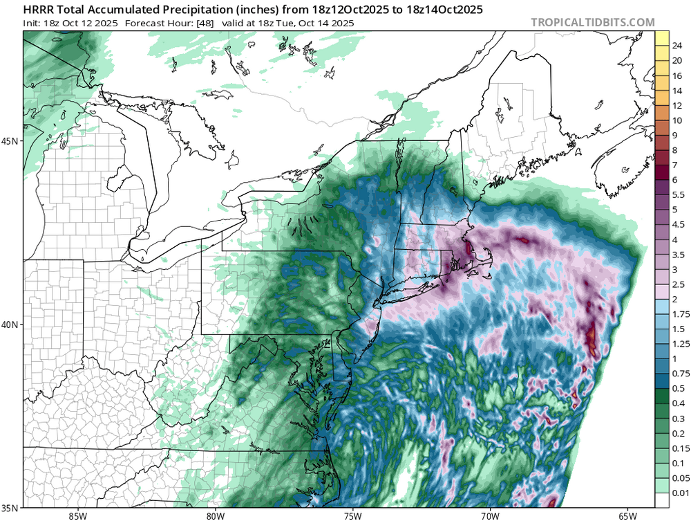
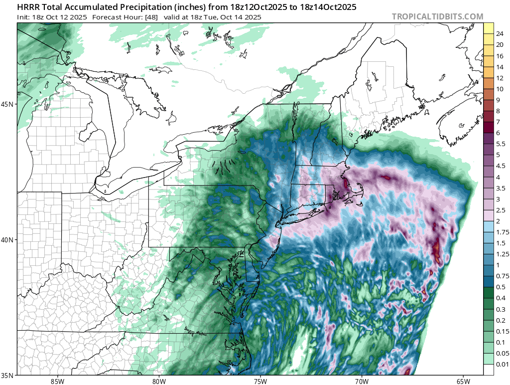
 0.17 inches in NE Queens so far The 18z NAMs have basically no rain until overnight/early tomorrow morning for my area and generally NYC which is comically bad considering these runs should have initialized with the NW edge of the precip already straddling the Hudson.
 -
Wind has been very impressive in the triangle for a nor Easter. I’d say gusts have been 30-35 all afternoon
-
 Moderate rain here but winds are nothing special. Was at Belle Harbor earlier and the waves were pretty large (though nothing too crazy).
 -
I see you found yourself back in the dead horse forum again
-
We had that same setup last year and it was very cold (compared to the last several years). Still couldn't even crack 13" in the park, and it's unlikely next winter will be as cold as last. The setup reminds me of 2022-2023 to be honest (2" of snow that whole winter).
-
 Forecast was 4.7 feet, got to 4.3... in terms of guidance, not bad at all. Should the winds crank up and winds stay east ish, should be done flooding in morning.
 -
 Little Egg Harbor Twp. gusted to 54 mph in the last 15 minutes from the NE.
- 443 replies
-
- 1
-

-
- heavy rain
- damaging wind
- (and 2 more)
-
That's bland, that's what the weather rock would say.
-
18z HRRR is wet for eastern SNE.
-
 Sure we do. It’s going to rain and be breezy. No surprises
 -
I am at 1.69" for my 2 day total. It has been a heavy drizzle and windy all day. Would feel raw if it wasn't 67 out there.
-
Today’s Euro Weeklies are hinting at some W Caribbean activity late month into early Nov with a moderate risk to S FL week of 10/27-11/2 fwiw. Just something to follow. Not something for them to get alarmed about right now, of course.
-

Spooky Season (October Disco Thread)
SnoSki14 replied to Prismshine Productions's topic in New England
We had all those huge -AO/NAOs last winter and no pig and still frequent SE ridges. These indices aren't playing out like they used to and that includes the so called pig low -
I guess not ranking 1st constitutes a "cooling" cycle nowadays lol
-

E PA/NJ/DE Autumn 2025 Obs/Discussion
BBasile replied to PhiEaglesfan712's topic in Philadelphia Region
0.01" so far today. 28 mph peak gust. 60F -
Hopefully we get better color here. Very disappointing to the west. It does seem a little slower this year as well. No rain at all today back here in the lowlands. Roads are dry and it's cloudy and breezy.
-
Even at game time is still not fully known what well exactly happen.
- 443 replies
-
- 1
-
-
- heavy rain
- damaging wind
- (and 2 more)
-
Kind of a classic coastal fall day with cool air, breezy conditions and rain. Hopefully a good sign as coastal tracks of any kind have been hard to come by
-
I was just thinking the same thing. If this were a winter storm, I would be crying in Greenfield.
-
-- Changed Discussion -- Generally minor to locally moderate coastal flooding occurred or is occurring with this afternoon high tidal cycle, as winds have been a bit on the lower side of ensemble guidance to this point, but moreso have been coming from the NNE vs more favorable NE/ENE for surge development. This forecast for late tonight and Monday afternoon high tides has been weighted towards a reasonable worst case scenario to account for closer to the coast depictions of low pressure track, providing a safety margin for planning. Water levels would fall on the lower end or short of current forecast range if winds remain more from the north versus the northeast. There is still potential for winds to veer back to the NE Monday if secondary low development occurs near the DelMarVa as suggested by some of the guidance. Potential for major coastal flooding for the southern bays of W LI and Jamaica Bay is dependent on the further north low pressure solutions and veering of winds to the NE. Overall, the magnitude and coverage for major coastal flooding (3ft inundation AGL) thresholds exceedance has decreased in the surge guidance as compared to yesterday for tonight and Monday afternoon, but still a modest threat of local major for SW Suffolk and Nassau County. This will pose an elevated threat to property, and potentially life. The potential for major flooding for Jamaica Bay is low, with moreso a widespread moderate coastal flood event (2 to 2 1/2 ft inundation AGL) Elsewhere, confidence is high in widespread minor to moderate coastal flooding along N and E facing coastlines along Western Long Island Sound, and twin forks of Long Island with combination of water levels reaching marginal moderate flood levels, along with 3- 6ft breaking wave action. In addition, widespread minor to moderate coastal flooding expected along NY/NJ harbor, including the tidally affected rivers of NE NJ, particularly the Hackensack River. Meanwhile, a widespread minor coastal flood threat exist for southern CT where NE winds should limit wave action and keep moderate flood impacts to localized. In addition, scattered areas of minor to locally moderate coastal flooding expected along low lying areas along the Hudson R during times of high tide this aft thru Monday aft as surge if forced up the river. No change to coastal flood headlines, but messaging on major flooding has been tempered a bit based on trends. A blend of 75th percentile Stevens, 75th percentile PETSS, and deterministic STOFS and ETSS was used for this forecast. The 75th percentile was still used in the ensemble guidance to give credence to NE vs NNE winds regimes and tidal piling over successive high tide cycles. Finally along the oceanfront, widespread dune base erosion and localized overwashes are likely during the times of high tide today thru Monday, via the combo of high stormtide and breaking surf around 8 to 12 ft. The prolonged e to w sweep will likely result in considerable beach erosion (escarpment) as well. 4-8 ft surf along NE facing and open water exposed areas of the twin forks of Long Island will also likely cause minor to moderate dune erosion. -- End Changed Discussion --
- 443 replies
-
- 1
-
-
- heavy rain
- damaging wind
- (and 2 more)
-
Yeah, maybe but for now the precipitation is having a hard time getting into NW Connecticut, and the Berkshires.
-
 Rain has made it west of 95
 -

The return of the elusive Nor'easter. Drought buster or bust?
JenkinsJinkies replied to dailylurker's topic in Mid Atlantic
Never -

E PA/NJ/DE Autumn 2025 Obs/Discussion
RedSky replied to PhiEaglesfan712's topic in Philadelphia Region
Precipitation is starting to move west into the region .25-.50" still going to fall possibly more then that -
Another bold post in October.


.thumb.png.4150b06c63a21f61052e47a612bf1818.png)
