All Activity
- Past hour
-
About 20 years ago (I'm guessing) an entomologist in Maine researched the critters and found that there was a significant (barely) relationship between the color bands and the subsequent winter. (Probably the above relationship - I don't remember. And I think it compared snow or snow/cold for full winters, without the early/late connection.)
-

2025-2026 ENSO
40/70 Benchmark replied to 40/70 Benchmark's topic in Weather Forecasting and Discussion
You absolutely nailed that...full credit. While my outlook went up in flames, it was one of the more instructional experiences that I have had in seasonal forecasting. This is why I always say the ones that are missed are our most valuable resources. We saw something similar with the 1972-1973 El Nino, but obviously this was warmer given CC. I think this year we may see something similar in that seasonals will overbake ENSO into the output. -
44 to 71 in just under 3 hours that's like desert recovery rates there
-
That’s why during the fall of 2023 I was pointing out the WPAC to IO would have more influence than we typically get with such strong El Niños. It lead to me doubting the Euro seasonal forecast of the typical Nino trough with colder conditions in the Mid-Atlantic and Southeast. The ridging in Canada was also stronger and more extensive than we typically see with El Niño events building down into the East which we usually see with La Ninas. So effectively a hybrid pattern with the warmest features of an El Niño and La Ninas merged together. We got early hints this would be the case back in May 2023 when the historic ridge developed over Canada leading to the record wildfire season. So there are clearly multiple areas of record SST warmth contributing to the overall pattern. In the old days we could just look at Nino 3.4 and have a reasonable assumption of what the pattern would look like. Now as I have been saying we have to deal with competing influences from these numerous areas of record SST warmth. This has been one of the reasons these seasonal models have been having so much of a challenge with the recent winter forecasts. The stock El Niño and La Ninas composites from the colder climate era are not manifesting in the same ways anymore. We first got a sample of this when the El Niño forecasts in 2018-2019 and 2019-2020 failed to couple due to the record SST warmth from the IO into the WPAC.
-
I have a feeling that's the case again for today. Wait for cool dry air in this area is like watching paint dry while it's drizzling.
-
It's so dry..it's so dry...sooo dry.. He moves in mysterious ways.
-
And back to boring.
-
That's mindblowing to see that up north.
-
Many forecasts of mostly sunny, or even just sunny, over the past three months have ended up the opposite, sometimes the clearing was delayed until sunset.
-
2025-2026 ENSO
40/70 Benchmark replied to 40/70 Benchmark's topic in Weather Forecasting and Discussion
It's all interconnected somewhat and we don't yet fully grasp how, nor the full breadth of the ramifications of said connection. -
Ultimately I think this is a good example of what @40/70 Benchmarkis always talking about and why we have to resist the urge to view things in isolation. I view the winter pattern like the mosaic of ripples on a pond if you were to throw a few stones in. Each stone could be a different index or measure of forcing. It's not the individual ripples that matter, it's the collection and how they interact that matters. Some years ENSO is the biggest stone, but maybe not in the case of 23-24. Similarly, when I look at the global SSTA's this year, there is no doubt that the North Pacific is going to be our biggest "stone". But even then we have to be careful to not simplify it to a "hot north pacific". The relative location of the max anomalies and gradients matters. And you can't pick that kind of stuff up from a blanket index. That is why although in theory you could say well we have a big negative pdo, enso, and iod so that means such and such, but it's the details within these zones that may make or break winter.
-
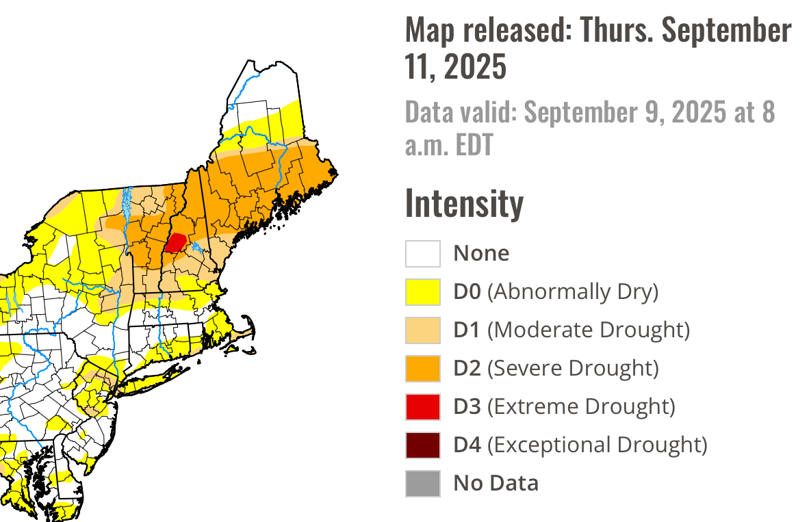
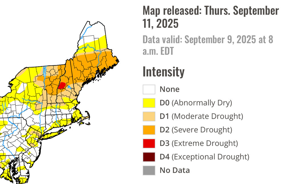
Pffft, you're not even in D3.
-
A perfect light soaking rain last night. Just enough to reprieve the short root grasses and alleviate tree leave stress. The farmers... are not happy, too little for a proper late season growth spurt, and just enough to make everything that has reached maturity damp.
-
Yeah, the last cold and snowy month around our area in January 2022 actually had a strong +NAO pattern. We were able to get that great MJO 8 and have one cold snowy winter month. But the ridge axis over the Rockies was a little too far east so this favored coastal areas for the heavy snows instead of areas south and west of NYC.
-
528 touching Northern Maine!!
-
-

September 2025 OBS-Discussion centered NYC subforum
SACRUS replied to wdrag's topic in New York City Metro
Quickly up to 72 here -
yup...oh well. It was fun to look at while it lasted
-
I could actually end up with less rain in September than August. Impressive.
-
It could come back... but you're proooobably safe. truth be told .. the diving cold pool cinema of Euro/GGEM looked a little dubious all along. I wouldn't sell at least a diving S/W, though - not sure that would be enough to trigger much but the risk wouldn't be zero. As related topic ... this journey is a nice example of the recurring de-amplification theme that's been plaguing all guidance really for several years on going. I mean at this point I just automatically deduct something like 20 or even 40% off any D7 anything the models might be showing at that range. If a cyclone is on the EC in a Euro's D8, it has to be a 950 mb worst storm in the history of Jupiter in order for us to achieve a standard Nor'easter. I'm not sure why that is, that seemingly dependable amplitude collapse when moving modeled events from .. D8s to D4s and so forth. I am a decent sci fi author. I can pen all kinds of plausible causes for that predictable error - speculation. I'd love to have a lunch with the director of modeling at NCEP - if any such post actually still exist.. heh. Speak candidly about this subject. I could see all this being done deliberately, so that they always see the worst case scenario - plausible cause 1. I mean, they're not in the business to entertain us, much to our chagrin. Their responsibility is to protect people and property. So, it would be bad if they were always modeling pieces of shits that turned into historic roses going the other way, huh. Or not. who knows
-
Had another low of 45 degrees. We are getting spoiled.
-
Last time we had a potential blob a storm came and destroyed it.
- Today
-
Apparently there is a South Pole stratwarm event that also happened in 13-14. Long explanation at the severe weather EU site about how that could be a sign of what the pattern will be here this winter. https://www.severe-weather.eu/category/global-weather/
-
there was actually a recent research paper that came out that attributed the lack of extreme teleconnections in the 2023/24 strong/super nino to an equally, if not more anomalous warming in the tropical Indian and Atlantic oceans, which is certainly interesting to think about how this will affect how seasonal forecasts are conducted in the future https://www.nature.com/articles/s43247-025-02584-8
-
it's funny, i am planning a family gathering at the house Sunday. Based on the forecasts I have seen, i have been focusing on having an indoor event. then I wake up this morning and not a drop of rain in the forecast. weird how that works. Of course if i change my plan to an outdoor event, 100% chance it will rain