All Activity
- Past hour
-
NAM and its replacement
-

Central PA Summer 2026 Discussion/Obs Thread
canderson replied to Voyager's topic in Upstate New York/Pennsylvania
Considering the thick cloud deck and now rain, severe won’t be an issue for Harrisburg today. -
Yeah not surprised honestly. Like Scoot said…more synoptic up here and convective down there. If Rufus is the future it still has a dual jack in S NH and the S coast. Funny how the globals are wetter up here than the NAM and HRRR now.
-
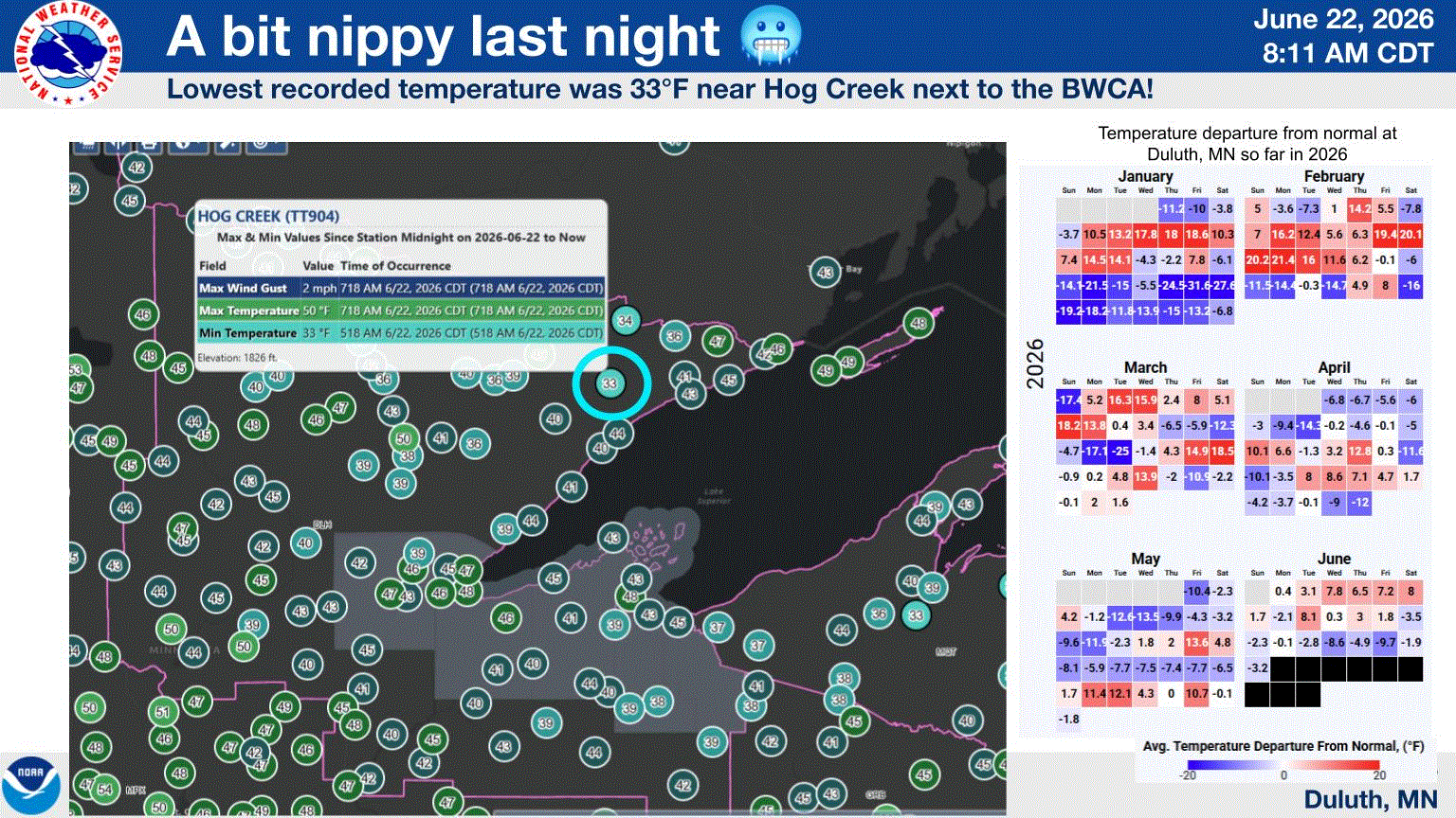
Low 30's to mid 40's across the area this morning with highs expected around 70. I'm sure there was patchy frost in some localized areas.
-
Hmmm. But the heating usually helps build the storms. I'm not saying it can't happen, but it's less likely. I just picked up 0.02" with the showers that clipped north jersey. I don't think that will be it but this is contingent on some factors coming together, and they don't always. I'm watching the area now over W. Virginia and eastern Kentucky to see how that does and if it builds more as it moves east northeast. Also the area way back in Tennessee and Arkansas would give some potential if it holds and /or redevelops.
-
Another cool morning with upper 30’s at my place. Eagle Mine about 10 miles nw of me down to 31. Should see mid 60’s today and a bit warmer tonight w/ mid 40’s. Have about 6 weeks of good garden weather before the sun begins to sink behind the trees and hill to my south and west, essentially shading my garden from 3 pm on. Rooting for a couple weeks of mid to upper 80’s and humidity between now and then.
-
Wagons all around Taunton except Taunton?
-

Wet late Monday 6/22 or another Fizzle?
Weather Will replied to Weather Will's topic in Mid Atlantic
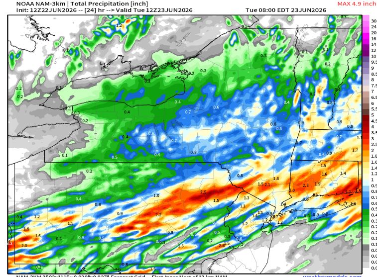
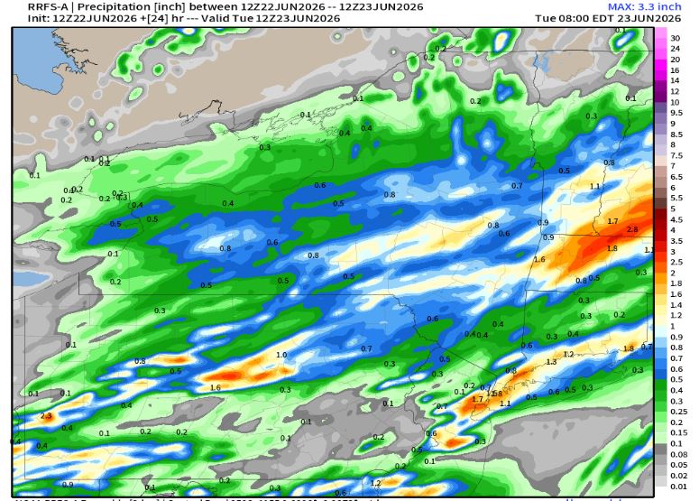
WB 12Z RRFS through Tuesday.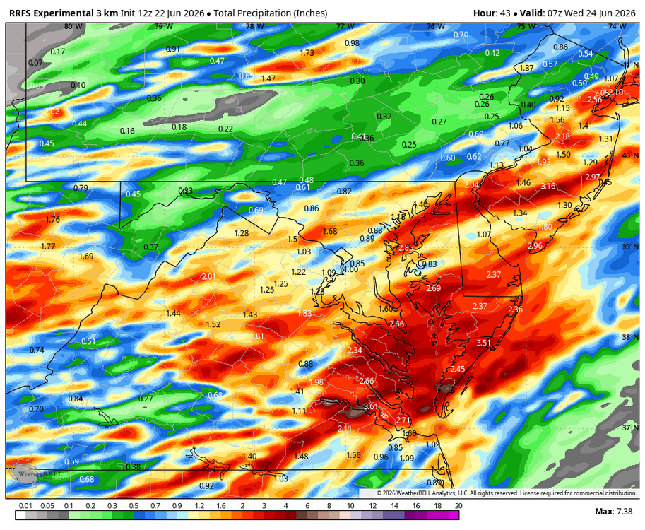
-
June 22 1988: Smoke fills the sky across much of Minnesota due to wild fires during the '88 drought. 1919: The 2nd deadliest tornado in Minnesota history hits Fergus Falls, killing 59 people. Like the #1 killer tornado for Minnesota (73 fatalities in St. Cloud and Sauk Rapids on 4/14/1886), it struck on a weekend. 1917: Grand Meadow has an intense downpour, and 4.98 inches of rain on this date. Corn crops are badly damaged by the heavy rain/flooding. For Monday, June 22, 2026 1947 - Twelve inches of rain fell in forty-two minutes at Holt, MO, establishing a world rainfall record. That record was tied on January 24-25, 1956, at the Kilauea Sugar Plantation in Hawaii, as their state record was established with 38 inches of rain in 24 hours. (The Weather Channel) 1972 - Hurricane Agnes deluged Pennsylvania and New York State with torrential rains resulting in the most costly flood in U.S. history. In the Middle Susquehanna Valley of Pennsylvania, 24 hour rainfall amounts were generally 8 to 12 inches, with up to 19 inches in extreme southwestern Schuylkill County. At Wilkes-Barre, PA, the dike was breached destroying much of the town. Flooding resulted in 117 deaths and 3.1 billion dollars damage. (David Ludlum) 1981 - A young woman from Lubbock, TX, was struck by lightning. The bolt of lightning struck just above her right shoulder near her neck, and passed right to left through her body, tearing her warm-ups, causing her tennis shoes to explode, and lifting her two feet into the air. (The Weather Channel) 1987 - Thunderstorms in southern Texas produced wind gusts to 116 mph near Quemado. Thunderstorms in New York State produced 5.01 inches of rain in 24 hours at Buffalo, an all-time record for that location, and produced an inch of rain at Bath, PA. The temperature at Fairbanks AK soared to 92 degrees, establishing a record for the date. (The National Weather Summary) (Storm Data) 1988 - Sixty-five cities in twenty-four states reported record high temperatures for the date. Tucson AZ reported an all-time record high of 114 degrees, surpassing the previous record of 112 degrees established a day earlier. Highs of 98 degrees at Pittsburgh, PA, and 100 degrees at Baltimore, MD, tied records for the month of June. (The National Weather Summary) 1989 - Record cold temperatures were reported in the High Plains Region. Rapid City, SD, reported a record low of 39 degrees, in sharp contrast to their record high of 102 degrees two days earlier, on the 20th. (The National Weather Summary) Observances: 22 Mon National Limoncello Day 22 Mon National Onion Ring Day 22 Mon National Chocolate Eclair Day 22 Mon World Rainforest Day 22 Mon National HVAC Tech Day 22 Mon National Pet Choking Prevention Day 22 Mon Positive Media Day
-
Wet late Monday 6/22 or another Fizzle?
Roger Ramjet replied to Weather Will's topic in Mid Atlantic
Got you beat - I had 22. -
Wet late Monday 6/22 or another Fizzle?
Weather Will replied to Weather Will's topic in Mid Atlantic
I just had 20 drops fall on my yard. Heading due east.... -
So much for wagons North.
-
the cluster now in WV is headed our way, but will is survive the mountains?
-
most of the storms are overnight so it's not a heating type setup.
-
My guy stops cutting which is nice. I feel bad for the loss of income though
-
Obviously some hyperbole there, but I jsut don’t see anything deep summer for a long time aside for a few days to start July.
-
 Yo Don... something to maybe keep an eye on. The longer range ensembles from all, EPS/GEPS/GEFS are doing something interesting. First, a strong -PNA wave function sweeps the continent. An ~ 90W ridge balloons. However, just when the heat is poised to move in here, we either only get day or so, or perhaps a failure/ shunt entirely. The reason is the total scaffolding suddenly, rather abruptly ( suspicious, more below) en mass the fields roll back out W. Not clear why that is happening and it is suss, but that reposition to the Sonoran Desert/PHX region instead would make Europe seem a like a mild day to the Inuit. Talking 120+ to perhaps the big 1 3 0s Hell hath no fury should a Sonoran Heat Release ever actually happen. About that... not sure it will. The hemisphere has been persistent really since last summer. Year's worth or more ( frankly) and counting. Hell bent on making sure we continue what happened all last winter: SE Can/NE U.S. is the coolest relative to the whole planet despite every month at a Global empirical result being 1, 2 or 3 warmest since thermometers were invented. Right now, currently being in 3rd place for historic inferno at a Global scale for June; which is likely end in 2nd or even vying for 1st. This looking back along this behavior, it's about a .75 to .12 C gain to loss ratio/behavior, so granted, I'm only roughing a linear extrapolation; if so the abv slope figures for about 16.8 by the end these next 9 days but we'll see.... One thing I'm noticing about that retro/heat rollback west, however... It looks too sudden, at too large of a scale. The entire mass of the planet won't do this typically. It seems to be happening right as the entire scope of the hemisphere ( in all three ens systems) suddenly abandons the anomaly distribution. All wave functions, on-going, just abruptly dissolve/collapse into base-line above average everywhere ... Odd. that en mass unilateral holistic behavior all at once ... mmm that's suss to me. But we'll see.
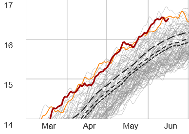
-
Seems like tomorrow morning is our best shot, but that could easily miss south.
-
Average to just above normal is fine for July and August All set with that HHH (94/78) bs
-
Of course they still come around. They need their weekly pay day
-

Junorch obs and discussion 2026
TauntonBlizzard2013 replied to Damage In Tolland's topic in New England
Looks like it’s going to be hit and miss with the rain here later today and tonight. NNE looks like a better spot for widespread stuff. Hope we catch a downpour -
Ha. I know we’re entering niño, but I think we need to define “summer” before I cancel it. usually finds a way to get us somewhat AN.
-
Well we definitely have more humidity today. Here in Frederick is is pretty much overcast with some occasional peaks of blue skies. Where I am at currently I can see the Catoctin Range and it is a gray haze looking West over them. Not sure what to expect from today. Either I will be surprised by some rain maybe even some rumbling. Or it will just be another overcast humid day. 50/50 craps shoot.
- Today
-
When did I ever say that? It's been comfortable other then a week of crap.. a/c has been off most days.. I don't live south of the Pike so honestly don't care .. you say some dews 65 to 70 so you can claim that your right even its just a day or two.. were going to have (some) days in the 70s.. ill claim victory now
-

Junorch obs and discussion 2026
Damage In Tolland replied to Damage In Tolland's topic in New England
You are acting like it’s been a cool BN summer. I mean look at the MTD numbers lol. After today’s failed heavy rain event south of pike it’ll warm AN rest of week . And the Julorch look the first 10 days or so looks similar. AN with some dews of 65-70 and no big heat. That’s still a very summer pattern