All Activity
- Past hour
-

The “I bring the mojo” Jan 30-Feb 1 potential winter storm
PeeDeeWx replied to lilj4425's topic in Southeastern States
Will short range models start picking up where dry slot will likely be? -
 It’s a legendary weather meme for all time
 -

Richmond Metro/Hampton Roads Area Discussion
RVASnowLover replied to RIC Airport's topic in Mid Atlantic
And then warm stretch with an inch of rain -
The record low max for NYC today is 16F set in 1934. That was followed by even colder weather in February. The max on Feb 9 was just 8F. Another record was set on the 25th of February (16F). The next coldest maxima for Jan 30 are 18F in 1908, 19F in 1977, and 20F in 1873, 2010. Tomorrow's record low max is also 16F shared by 1935 and 2019. It was likely colder in the daytime on Jan 31, 1920 but an early midnight high prevented a record, by the next midnight it was below zero setting records for both Jan 31 (-1F ) and Feb 1 (-2F). Today's record low was -1 in 1873. Since then, the coldest readings have been 8F in 1908 (and 1952), 4F in 1935 as well as 1948, and 6F in 2019. It was then 2F for a low on Jan 31, 2019.
-
12z GDPS
-

February 2026 Medium/ Long Range Discussion: Buckle Up!
stormtracker replied to Weather Will's topic in Mid Atlantic
GFS is south of 6z so far, lol -

Arctic Hounds Unleashed: Long Duration Late January Cold Snap
ma blizzard replied to WxWatcher007's topic in New England
Looks like that is the all time record low for ORH? Must have been some serious fake cold to put up a 24/-24 on the day 2/9/1934 only other sub -20 min on record and 2/-20 on the day -

February 2026 Medium/ Long Range Discussion: Buckle Up!
frd replied to Weather Will's topic in Mid Atlantic
NAO is dropping at that time, as the NAO block starts to rebuild then forecast to retrograde Westward. -

February 2026 Medium/ Long Range Discussion: Buckle Up!
mitchnick replied to Weather Will's topic in Mid Atlantic
Height lines are oriented nw/se at 99hrs. Pretty low probability it does. -

The “I bring the mojo” Jan 30-Feb 1 potential winter storm
MDsnowPRO replied to lilj4425's topic in Southeastern States
Not completely true, there was equipment on site but it was limited for sure. Took a long time to get everything cleaned up. -
Yeah we haven’t had the sun so far down here .
-

Richmond Metro/Hampton Roads Area Discussion
wasnow215 replied to RIC Airport's topic in Mid Atlantic
This 12z GFS run looks more like the European model has most of the runs the last few days -
February 2026 Medium/ Long Range Discussion: Buckle Up!
stormtracker replied to Weather Will's topic in Mid Atlantic
It won't. -
Exact opposite is happening in West Knox. Already at 35 degrees. Need the cloud deck to thicken
-
The 12/24 evening half inch or snow before the flip to rain was forecast well. But they had a WS watch out for 4pm and onward on 12/25 for a change back to snow but they dropped it at 9am on 12/25 when the ETA came in very mild and the Euro was very skeptical on it. The GFS was going wild with 6-10 inches of backend snows but NCEP was heavily discounting it and so the WFOs more or less did too. The AVN/MRF had been merged just 8 weeks prior so I think there was some concern about the reliability of what it was showing.
-

Arctic Hounds Unleashed: Long Duration Late January Cold Snap
WxWatcher007 replied to WxWatcher007's topic in New England
Now those are obs -
FWIW: I'm running about 3-4 degrees below from forecasted highs so far
-

February 2026 Medium/ Long Range Discussion: Buckle Up!
Ji replied to Weather Will's topic in Mid Atlantic
ya that trend has to stop asap -

February 2026 Medium/ Long Range Discussion: Buckle Up!
TSSN+ replied to Weather Will's topic in Mid Atlantic

-
And NYC should be a few inches higher, the 2 Dec storms were pretty blatant under measurements at Central Park. But I agree, disappointment tomorrow aside it’s been a great winter so far.
-

February 2026 Medium/ Long Range Discussion: Buckle Up!
SnowenOutThere replied to Weather Will's topic in Mid Atlantic
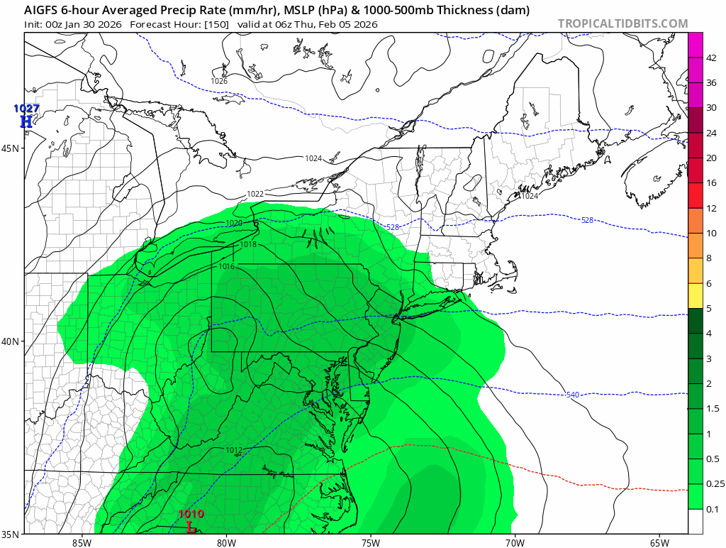
This seems fine? No need to panic yet as it’s still a good depiction. -

Richmond Metro/Hampton Roads Area Discussion
overcautionisbad replied to RIC Airport's topic in Mid Atlantic
Not really. There have been plenty of cold stretches of winter with no snow. -
February 2026 Medium/ Long Range Discussion: Buckle Up!
TSSN+ replied to Weather Will's topic in Mid Atlantic
Ai gfs is a nice hit but it’s sinking south each run so I’m sure soon it will be a miss south. -

The “I bring the mojo” Jan 30-Feb 1 potential winter storm
Buddy1987 replied to lilj4425's topic in Southeastern States
Impossible forecast up both our ways.. actually snowing pretty decent here current moment however. Maybe it's a good harbinger of things to come! -
February 2026 Medium/ Long Range Discussion: Buckle Up!
stormtracker replied to Weather Will's topic in Mid Atlantic
Let's see what shit the GFS gets into. H5 is different S/w looks slightly stronger