All Activity
- Past hour
-
Im looking out the window beyond my Christmas decorations at a glistening blanket of snow. I can think of worse scenarios to be in in early December. And no, that doesn't mean i dont want a big storm too
-

Winter 2025-26 Short Range Discussion
RemoteSenses replied to SchaumburgStormer's topic in Lakes/Ohio Valley
Looking ahead to next week - models keep going back and forth with two waves. Tuesday's seems to be fizzling out but Wednesday/Thursday could be a quick dumper. -
Us northern tier folks just can’t win anymore. It’s either south of us or so far north it doesn’t matter. Congrats dc south crew.
-
The one time I was rooting against snow. Scheduled to take 9am bus from Vienna up to NYC tomorrow morning to celebrate my birthday this weekend.
-
12z Euro-AIFS
-
Moline IL set all.time low season snow last winter (8.2") and passed that total thus year in NOVEMBER
-

December 2025 regional war/obs/disco thread
WinterWolf replied to Torch Tiger's topic in New England
You’re a beggar…you can’t be choosy…be happy we have one major at the moment suggesting something…and it’s ensemble also. -
12z Euro
-
Iowa is rarely the hot spot because of no lake help of any kind. They can get a good storm though.
-
Acknowledged captain haha. I hear you... and yes we all do. My question is, do you believe this is strictly an east coast storm issue? The reason I ask is that we see plenty of tight phasing pretty much anywhere still. Seriously, not trying to be an ass.. just curious
-

Central PA Fall Discussions and Obs
canderson replied to ChescoWx's topic in Upstate New York/Pennsylvania
Ambien for me. Snow squalls doing there thing in the normal squall parts of the region -
Hip, hip, hooray! 12z Euro is here to save the day!
-

December 2025 regional war/obs/disco thread
Typhoon Tip replied to Torch Tiger's topic in New England
12z GEFs mean has a higher latitude center jump suggested for the 8th. Much better presentation for something in this window comparing to the 00z. 06z interim run did step wise improve so this is a trend. I don't think the operational run is complete garbage - as I've outlined, there's a +PNA burst, albeit minoring but there nonetheless; so there's a background tendency for more amplitude ( correction vectoring - ). ...Not a major by any means -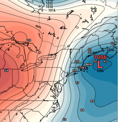
-
We had 5 in Westfield. My nephew in Granville had 6.25
-
Fire Up Chips! I initially started there for Meteorology but after one semester, it wasn't for me long-term. I ended up graduating with a degree in GIS tho which has a lot of overlap with the MET group.
-
Yeah 3-4” of fluff and still coming at the Mtn.
-

Winter 2025-26 Short Range Discussion
Chicago Storm replied to SchaumburgStormer's topic in Lakes/Ohio Valley
Final snowfall totals from yesterday’s duster 0.5" - Home 0.4" - ORD T - RFD …2025/26 Season Snowfall... 12.3" - ORD 11.9" - Home 11.3" - RFD -
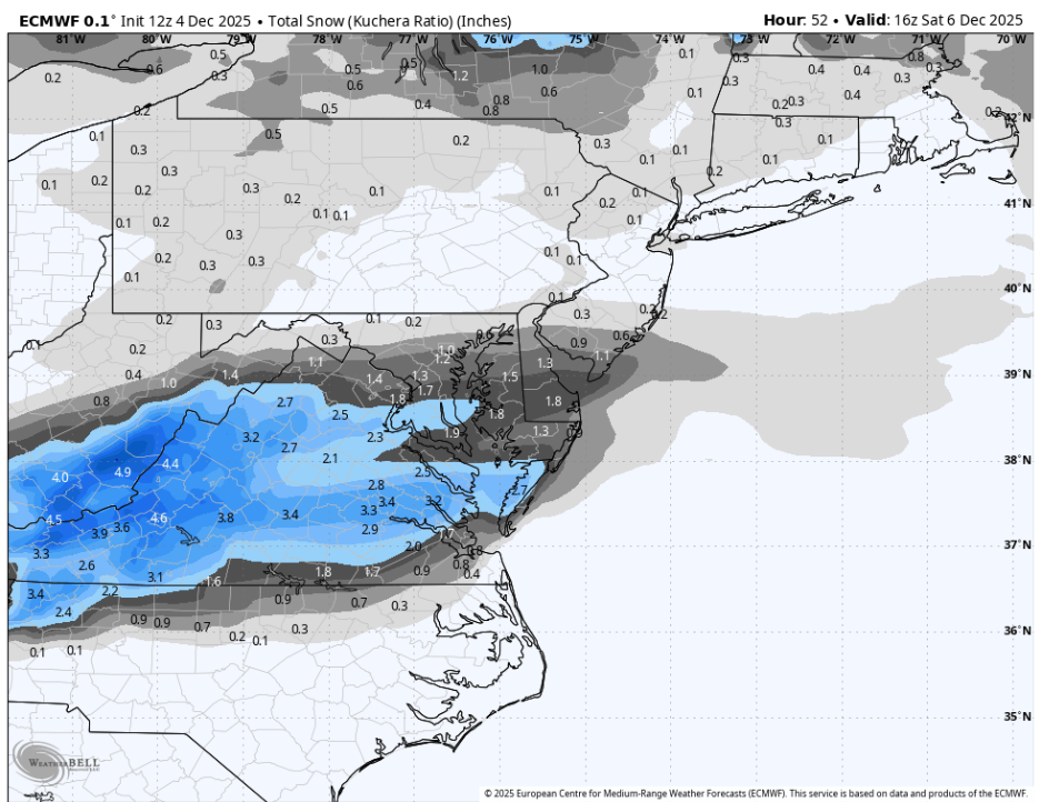
URGENT - WINTER WEATHER MESSAGE National Weather Service Baltimore MD/Washington DC 1213 PM EST Thu Dec 4 2025 MDZ016>018-VAZ055-502-527-050115- /O.EXB.KLWX.WW.Y.0023.251205T0900Z-251205T2100Z/ Charles-St. Marys-Calvert-Stafford-Southern Fauquier-Central and Southeast Prince William/Manassas/Manassas Park- 1213 PM EST Thu Dec 4 2025 ...WINTER WEATHER ADVISORY IN EFFECT FROM 4 AM TO 4 PM EST FRIDAY... * WHAT...Snow, with total accumulations of 1 to 2 inches. * WHERE...Portions of southern Maryland and northern Virginia. * WHEN...From 4 AM to 4 PM EST Friday. * IMPACTS...Plan on slippery road conditions. The hazardous conditions will impact the Friday morning commute. * ADDITIONAL DETAILS...Given temperatures will be in the 20s, snow is expected to accumulate on all untreated surfaces. A light snow will overspread the advisory area, with slightly higher amounts possible in any banding features. As snow winds down, a light freezing drizzle is possible into Friday evening.
-
URGENT - WINTER WEATHER MESSAGE National Weather Service Baltimore MD/Washington DC 1213 PM EST Thu Dec 4 2025 VAZ026-029-039-040-051-503-504-050115- /O.EXA.KLWX.WW.Y.0023.251205T0600Z-251205T2100Z/ Rockingham-Page-Madison-Rappahannock-Culpeper-Western Highland- Eastern Highland- 1213 PM EST Thu Dec 4 2025 ...WINTER WEATHER ADVISORY IN EFFECT FROM 1 AM TO 4 PM EST FRIDAY... * WHAT...Snow, with total accumulations of 1 to 3 inches. Localized totals around 4 inches are possible over the higher elevations of Augusta and Highland Counties. * WHERE...Portions of northern, northwest, and western Virginia. * WHEN...From 1 AM to 4 PM EST Friday. * IMPACTS...Plan on slippery road conditions. The hazardous conditions will impact the Friday morning commute. * ADDITIONAL DETAILS...Given temperatures will be in the 20s, snow is expected to accumulate on all untreated surfaces. A light snow will overspread the advisory area, with slightly higher amounts possible in any banding features. As snow winds down, a light freezing drizzle is possible into Friday evening.
-
URGENT - WINTER WEATHER MESSAGE National Weather Service Baltimore MD/Washington DC 1213 PM EST Thu Dec 4 2025 VAZ025-036>038-050-056-050115- /O.CON.KLWX.WW.Y.0023.251205T0600Z-251205T2100Z/ Augusta-Nelson-Albemarle-Greene-Orange-Spotsylvania- 1213 PM EST Thu Dec 4 2025 ...WINTER WEATHER ADVISORY REMAINS IN EFFECT FROM 1 AM TO 4 PM EST FRIDAY... * WHAT...Snow, with total accumulations of 1 to 3 inches. Localized totals around 4 inches are possible over the higher elevations of Augusta and Highland Counties. * WHERE...Portions of central and western Virginia. * WHEN...From 1 AM to 4 PM EST Friday. * IMPACTS...Plan on slippery road conditions. The hazardous conditions will impact the Friday morning commute. * ADDITIONAL DETAILS...Given temperatures will be in the 20s, snow is expected to accumulate on all untreated surfaces. A light snow will overspread the advisory area, with slightly higher amounts possible in any banding features. As snow winds down, a light freezing drizzle is possible into Friday evening.
-
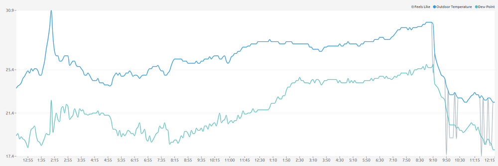
I know last weekend we did much better with temps running below normal for what they forecast. Earlier this week was about what they predicted so we will see.
-
This is probably the most deep winter day I’ve had up here so far.
-
Looks like mid-winter!
-
Somewhat, We should be good to go after this weekend.
-
Looks like the front is through at home.