All Activity
- Past hour
-
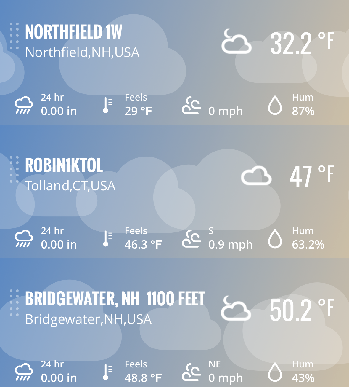
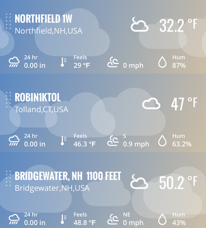
It's remarkable ... the autumn of the great unbalanced RAD proficiency continues. It's 48 at ORH ap, 28 here... Granted that's 800' of difference but 20F is about as extreme a still morning difference/RAD result as I've ever seen.
-
Today will be toasty. Good day for lunch outside.
-
Man, I can’t drive 55.
-
Falls Lake is 245.76 Feet so we are about 2-3 days from reaching the summer low.
-
Last night was the sharpest inversion yet. Below freezing in the valley but like 20F higher (50F) like 500ft above. It’s 30F at MVL but 55F (!) at 1,500ft.
-
Just missed the 30’s this morning, 40.1 Just absolutely amazing weather. Give me this every day of the fall (throw some rain in too)
-
Just unmitigated boredom coming up, but I guess I’ll take the nice stretches of weather.
-

2026-2027 Record-breaking El Nino
GaWx replied to Stormchaserchuck1's topic in Weather Forecasting and Discussion
The NOAA relative weeklies released this morning: -Nino 3.4 warmed slightly to +2.5. It remains at record levels for the time of year with it way ahead of the 2nd warmest, +2.0 of 2015. The record for any week is +2.9 of 12/29/82. -Nino 3’s +3.6 is much warmer than the 2nd warmest for the week, +2.9 of 1997 and it also ties the warmest for any week, 12/29/1982. -Nino 1+2’s +4.4 remains much warmer than its 2nd warmest for the week, +3.6 of 1997. Its warmest for any week is the +4.6 of 1998. 30SEP2026 4.5 3.3 2.3 0.1 07OCT2026 4.4 3.4 2.4 0.2 14OCT2026 4.4 3.5 2.4 -0.1 21OCT2026 4.4 3.6 2.5 0.0 https://www.cpc.ncep.noaa.gov/data/indices/rel_wksst9120.txt -
It’s kind of funny I’ll look at my thermometer and then as I walk outside in the dark to go to the gym, you can hear the leaves rustling in the wind. The wind just does not stop on my hill.
-
40.5 here but frost 60’ lower.
-
this morning.
-
 https://canpointerx.shop/# best online canadian pharmacy
-
If you remove Isaias this feels like Oct. 2000 with the dryness. Maybe we’ll find out Super Duper El Ninos actually behave like a Nina. I’ve been enjoying the beautiful weather though!
-
Mild up here on Tug Hill at 1500'. Barnes Corner is reporting 43 degrees. (Just practicing. I'm still in Maryland where it's colder at 38).
-
Had a nice mild run in shorts earlier under the Hunter Moon.
-
Bottomed at 28/27. Decent week upcoming.
-
Min 30° A wee bit warmer higher up
- Today
-
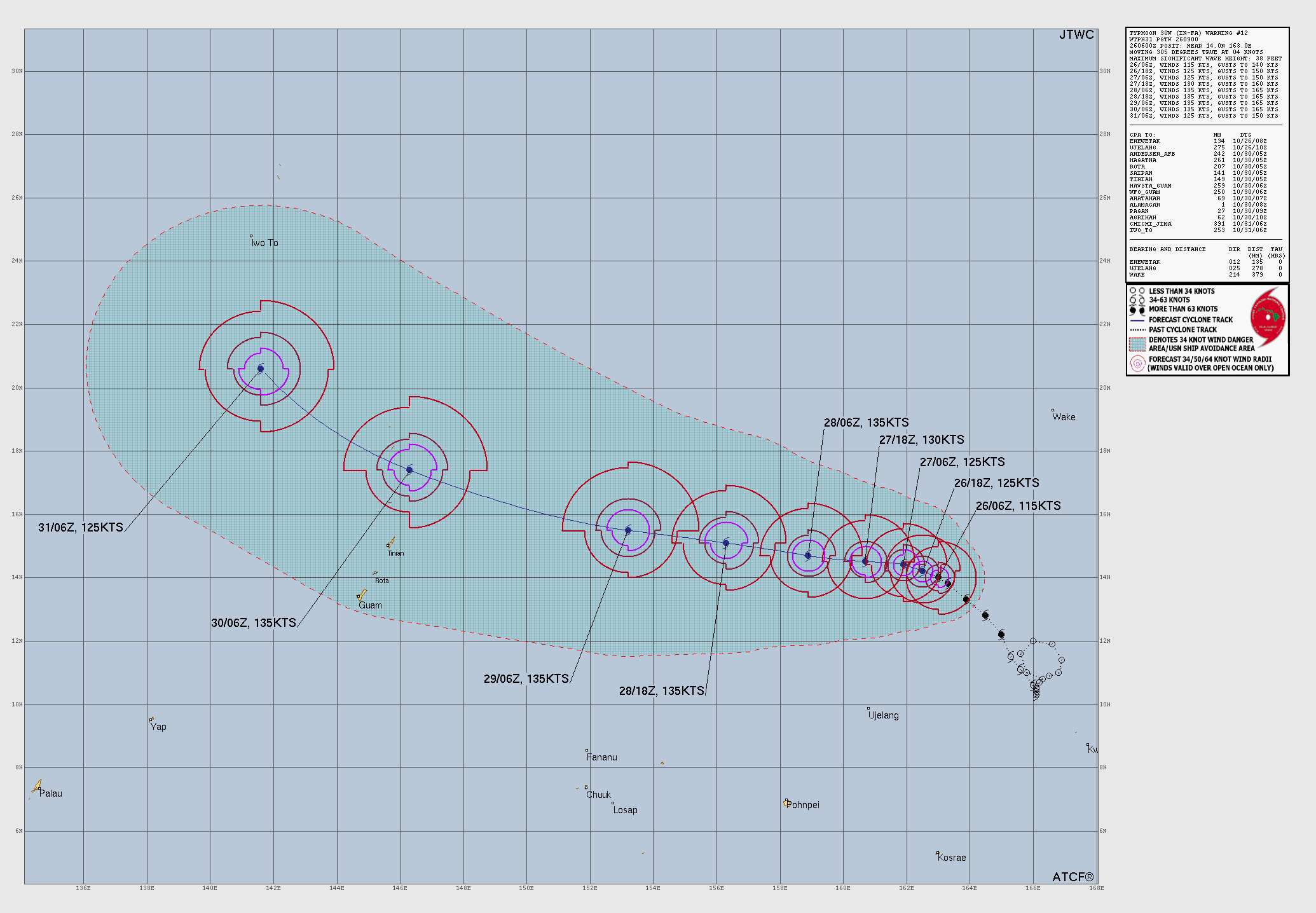
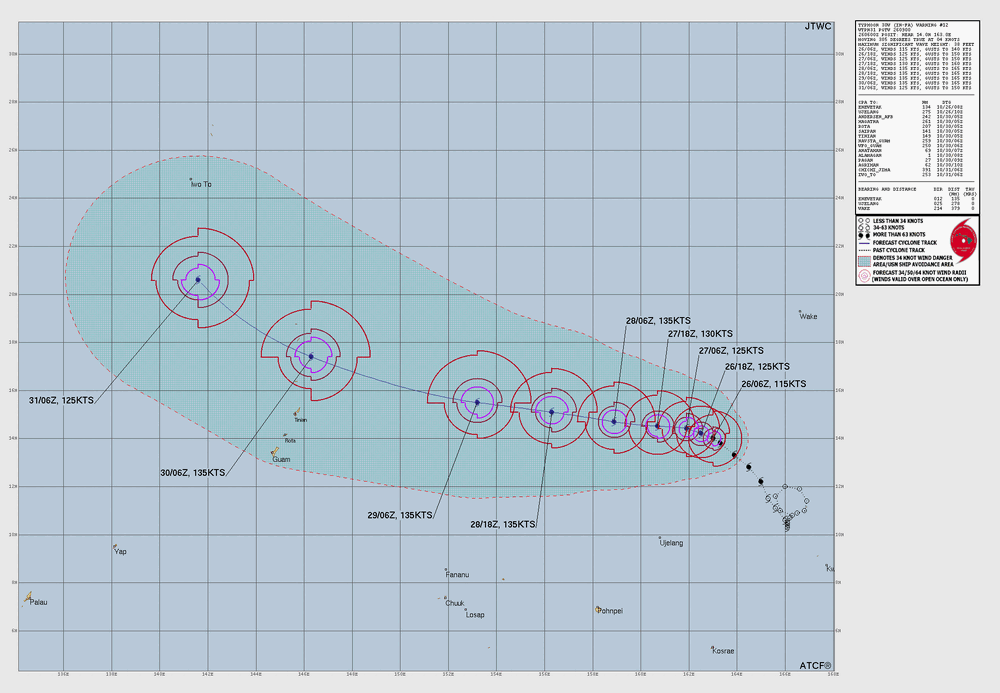
 In-Fa making its move to become the third STY this month. As a mentioned in a previous post, the NWPAC often makes it best moves Oct-Dec! NWPAC is now 17th all-time for ACE, but by the time In-Fa is done, it should be in in the top 10. Record NWPAC ACE for a season by far it 570.7 set in 1997 (very strong El Nino). Second place is 2004 w/ 477.5 and that was weak El Nino (modoki), but C/EPAC was well below avg, yet among the most active for the ATLC. The 1992 for third place, which is the 3rd most active for the C/EPAC. C/EPAC 4th all time is 2015 which is also 4th all time for the NWPAC (very strong El Nino year), so there is some correlation to record active in both basins and very strong El Nino, but you can see, more than one way to get a very active NWPAC season!
-
mexican pharmacies that ship to us: mexican pharmacy online reviews - legitimate mexican pharmacy online
-
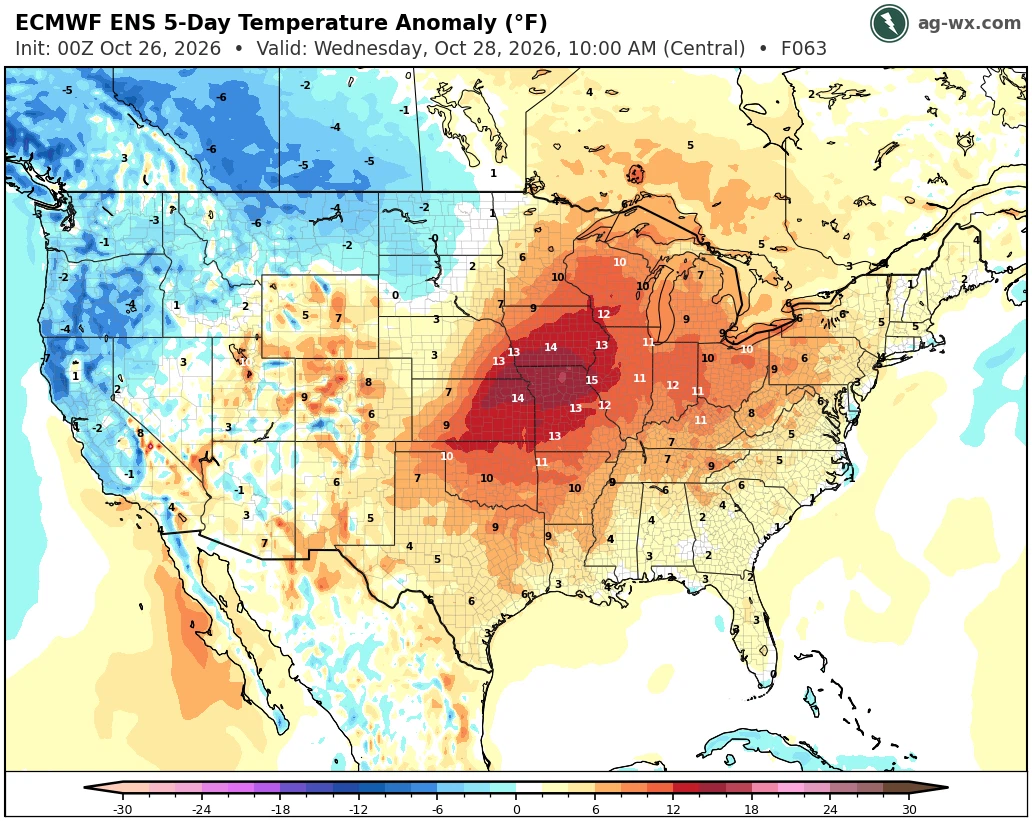
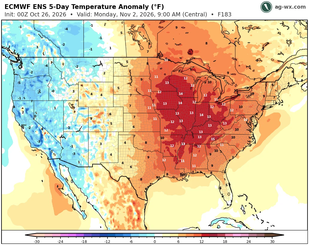
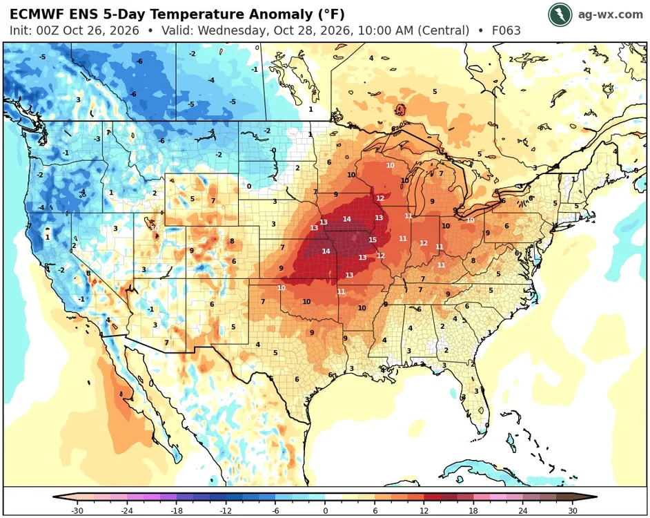
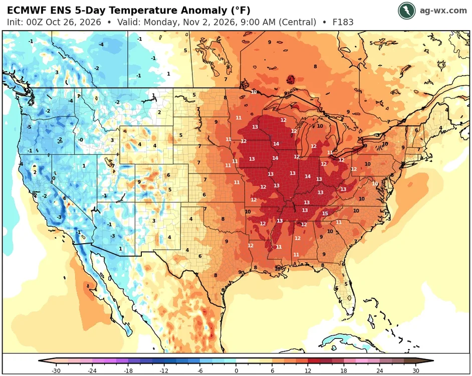
Yeah, the warmest departures which have been out in the Rockies this month will shift further east as we head into November. Climatologist49 @climatologist49.bsky.social Follow After finishing with the record warmest July, the record warmest August, and the record warmest September, the Contiguous U.S. is on pace to have the 4th warmest October on record. The warmest, 1963, was 4.8F above normal. It's still possible that this October could move higher up the list. 11:30 AM · Oct 23, 2026
-
29/28, another frosty one
-

E PA/NJ/DE Autumn 2026 Obs/Discussion
PhiEaglesfan712 replied to PhiEaglesfan712's topic in Philadelphia Region
Yes, 2 years ago, it didn't rain during the entire month of October. -
buy pharmacy online: ZenithIndus Rx - online medicine delivery service
-
Yeah, bottomed out at 30F. Gorgeous stretch of weather upcoming.
-
30 this morning with fog and frost. And almost 24 hrs. since anyone posted.