All Activity
- Past hour
-
Where can i sign up for text alerts? Nacho's lights are already flickering
-

January 24-26: Miracle or Mirage JV/Banter Thread!
SnowenOutThere replied to SnowenOutThere's topic in Mid Atlantic
-
Road is finally starting to cover up . That road salt is brutal
-

January 25/26 Jimbo Back Surgery Storm
Brick Tamland replied to Jimbo!'s topic in Southeastern States
I don't think the GFS has had as many wild swings as the Euro has the last two days. -
Ahh- I see....and yes, that would change pretty much everything at this point...early phasing would act as the kicker on the 50/50 and make it more progressive, correct? Some of the ensembles were showing this, but then I saw some others that had some genuinely bizarre solutions I still am skeptical of this without seeing more of the metadata being fed in- many of the other ensembles were all over the place with no coherent line of best fit
-
That's helpful dallen7908, but can I please have that in plain English, please? Approximately 7th grade English please.
-

January 24-26: Miracle or Mirage JV/Banter Thread!
Scraff replied to SnowenOutThere's topic in Mid Atlantic
Sup everyone! Sadly, I got suspended for fighting in the elementary school thread. Bitchin Nachos threw a Fruit Punch Capri Sun at me when I told him we’re probably only getting 6, maybe 7 inches tops. Siiiiiiiix Seeeeeeven. I threw a bowl of queso and salsa at him in retaliation. It wasn’t pretty.  -
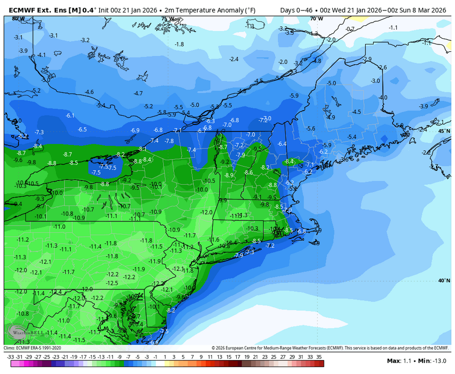
TMIN biases are seen in the eastern U.S. with the operational ECMWF forecasts’ largest low biases occurring in DJF (between 1.6–2.7 °C). The low bias is exacerbated when snow is present and the boundary layer is stable. See Lopes et al. 2024. ECMWF newsletter (2018) - Increasing the physical realism of surface processes in a model to reduce systematic biases may increase the root-mean-square error (RMSE) because different kinds of errors may no longer partially cancel each other. For example, 2-metre temperature (T2m) is computed diagnostically in the IFS from the temperature at the lowest model level and the skin temperature. There is a limiter in the computation of T2m which becomes active in very stable, low wind situations, and which prevents the T2m from deviating too strongly from the temperature at the lowest model level. Removing this limiter would be physically desirable, but tests have shown that doing so in the current model setup increases the RMSE.
-
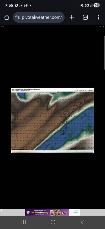
the Euro has little to no snowfall with a sounding like this leading up to the storm and blocking
.thumb.png.65aa6a53477ba0ed36472f8ee08ba2e5.png)
-

January 24-26: Miracle or Mirage JV/Banter Thread!
pazzo83 replied to SnowenOutThere's topic in Mid Atlantic
if they get a spot in the Glover Park DC to Bethesda grocery corridor, they will have made it in the DMV -
What about (apologies for asking) the NAM, CMC, Ukmet, icon?
-

Possible Record Breaking Cold + Snow Sunday 1/25 - Tuesday 1/27
jm1220 replied to TriPol's topic in New York City Metro
Look at 500mb before you look at the surface. What happens at 500mb drives what happens at the surface. You want to see strong confluence in SE Canada if we’re getting a full phase to our west. We’re having a ton of Gulf moisture overrunning into the high pressure dome so the surface is definitely relevant here, but the 500mb confluence allows that high to be in place and to force a redevelopment to our south. And you also want to pay attention to the 700/850mb low tracks, if they stay intact and track to our NW that means we have strong southerly flow from the Gulf at those levels and they will warm. But the big initial overrunning surge can mean a ton of snow falls before that warm air gets too potent at 750-800mb and whatever sleet just hardens up the snow pack into cement once it freezes up. I’ll gladly take 10 or 12” of mixed snow and sleet that freezes into cement. -
From the source:
-

“Cory’s in LA! Let’s MECS!” Jan. 24-26 Disco
Damage In Tolland replied to TheSnowman's topic in New England
Yes with videos of broken accordions smashed over sledding trails -
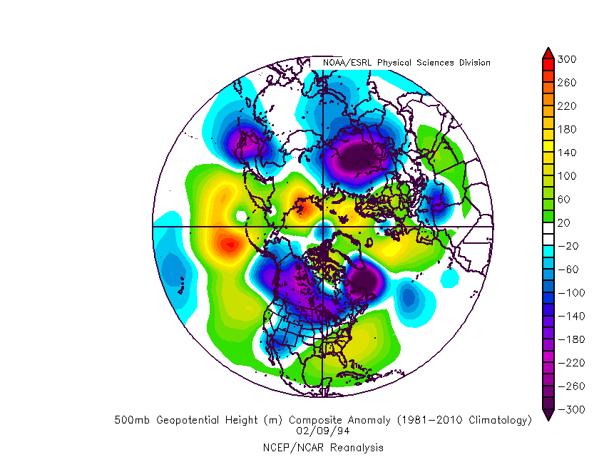
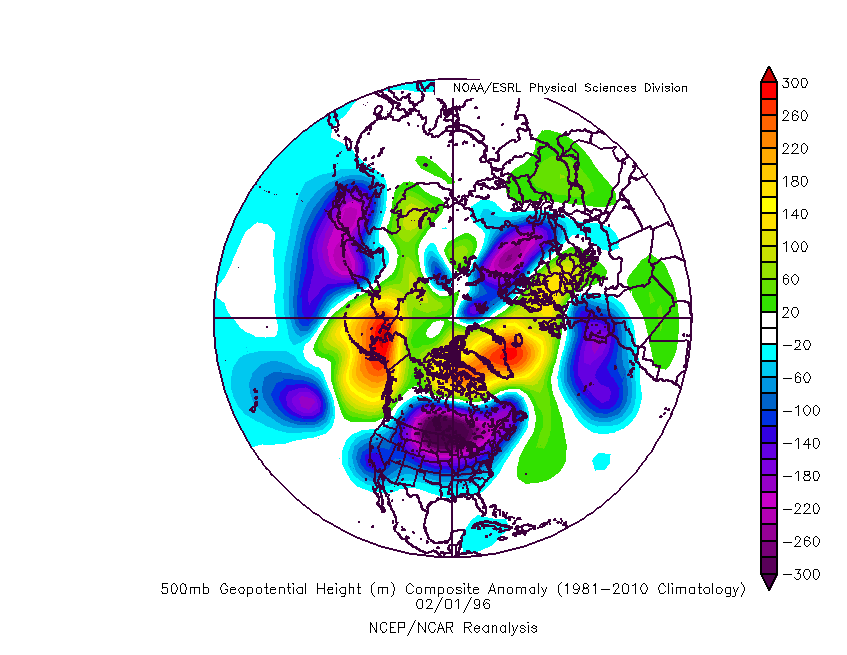
February 94 as well.
-

Possible Record Breaking Cold + Snow Sunday 1/25 - Tuesday 1/27
L.I.Pete replied to TriPol's topic in New York City Metro
Port Jeff Station got smoked. My favorite storm besides ‘96. . -

Central PA Winter 25/26 Discussion and Obs
SnowPlowGuy88 replied to MAG5035's topic in Upstate New York/Pennsylvania
I just work in that area, reside in Dillsburg. Would definitely be nice to meet up if we get this storm, as I am sure to be refueling the plow truck and diesel cans for the skid steer. Cheers to a hopefully historic storm! -

January 24-26: Miracle or Mirage JV/Banter Thread!
aldie 22 replied to SnowenOutThere's topic in Mid Atlantic
Right! So was that Leesburg 05 at Dabenchmark and the other Leesburg O4 at Weenietown all of them...total toolbags -

Central PA Winter 25/26 Discussion and Obs
Jns2183 replied to MAG5035's topic in Upstate New York/Pennsylvania
I guess it's due partly to the strength of the new low forming offshore and the timing of the phase but in a couple images I can show you whats stopping this from being a top 5 storm most likely. That dry air pours in during handoff shutting our preceiptitation off early Monday. The coastal doesn't really get going or does far too late due to the progressive nature and timing. I think some of the bigger totals like 24" plus were due to everything happening earlier and the phase being stronger allowing coastal to spin up. Yes we would definitely still dry slot some, and sleet might be an issue for a bit but the ccb makes those minor incidents for those lucky enough to be under it, although I'd wager at least 5 pages of doom posting during lull from those who a few hours later would be posting in ecstasy Sent from my SM-S731U using Tapatalk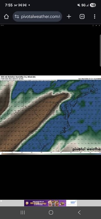
-
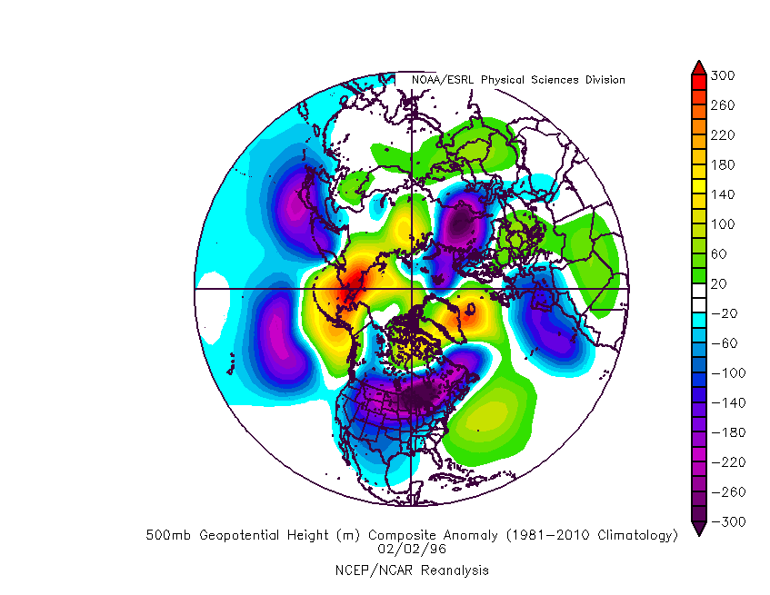
Look familiar? I think this is my favorite analog to this storm not Dec 2002.
-

January 2026 regional war/obs/disco thread
Sey-Mour Snow replied to Baroclinic Zone's topic in New England
-
Late saturday night through late sunday night. Worst of it being early Sunday morning through early afternoon. .
-

“Cory’s in LA! Let’s MECS!” Jan. 24-26 Disco
TheSnowman replied to TheSnowman's topic in New England
Or if I’m absolutely Furious you’ll know it’s good news. -

January 24-26: Miracle or Mirage JV/Banter Thread!
nj2va replied to SnowenOutThere's topic in Mid Atlantic
“Oh yeah, that guys a tool” -
Probably midnight Saturday night. Duration doesn't feel very hashed out right now.


.png.84e09f6d3a8a3f4fd01adecfad69e179.png)


