All Activity
- Past hour
-
It was F’ng hot at Lake Sunapee Country Club today. And Oh… most views looked like this.
-
hit 90.2 today.. I think we average 1 to 3 of them a year here so hopefully its the last
-
PA Storms to fizzle but cloud debris may linger into tomorrow
-
Highs: TEB: 90 EWR: 90 New Brnswck: 89 LGA: 88 NYC: 87 PHL: 87 BLM: 86 TTN: 86 ACY: 84 ISP: 83 JFK: 81
-
It definitely has that classic, mid-Atlantic swampy feel outside, I'm assuming in part due to how saturated the ground is. Nothing like the last few years.
-
Tomorrow will be another warm day with the temperature rising into the lower and perhaps middle 80s. A shower or thunderstorm is possible during the afternoon or evening. The weekend will turn somewhat cooler with high temperatures returning to the 70s. Showers and thundershowers are possible during the weekend. Rainfall amounts should generally be light except where scattered locations see heavier thunderstorms. The ENSO Region 1+2 anomaly was +0.8°C and the Region 3.4 anomaly was -0.1°C for the week centered around May 28. For the past six weeks, the ENSO Region 1+2 anomaly has averaged +0.17°C and the ENSO Region 3.4 anomaly has averaged -0.07°C. Neutral ENSO conditions will likely continue through at least mid summer. The SOI was +7.45 today. The preliminary Arctic Oscillation (AO) was +1.874 today.
- Yesterday
-
I want a repeat of July 1993 / July 2010
-

Mid to long range discussion- 2025
UnionCountyNCWX replied to wncsnow's topic in Southeastern States
Surprised there's not much chatter about Saturday yet. Looks like it could be an interesting afternoon accross a good portion of the SE. -
Nah, Give me a CAT3 or higher. /// Give me a 24hr. Blizzard You'd love Floridah WIZ
-
5 pm update Central Park reached 87 and the AQI peaked at 161 which is bad for EVERYONE. They said that the Canadian wildfire smoke wasn't just in the upper atmosphere but made it down close to the ground too which added to the problem with ground level ozone which we had since yesterday. My high was 85 here and 91 inside my house so I turned on my a/c at 4:30
-
I just saw that the SST near Montauk are already up to 73! No wonder Montauk was at 78 degrees at 4 pm! It's warmer there than it is in south NJ (69) or Fire Island (65).
-
89 was my high - def summer. It was quite miserable. Strong thin line of warned storms out west near Altoona.
-
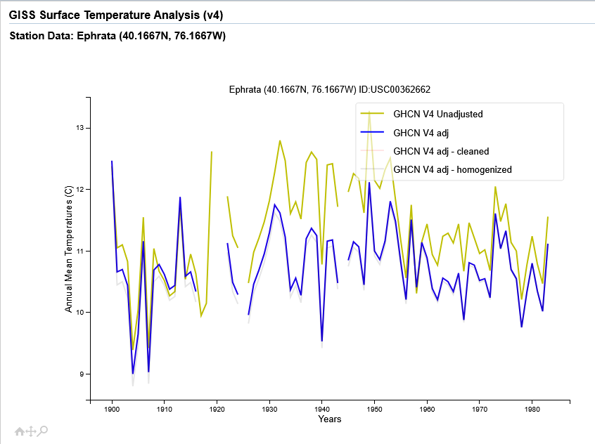
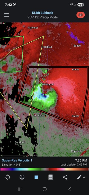
The GTG shear on the PDS warned tornado in western Texas was pretty high end for a few scans. Looks somewhat messy now.
-
 18/9/5
 -
16 more days and we start losing daylight, Can’t wait.
-
See how much happier everyone is posting heat/humidity obs? This is our happy place
-
No one in Chester County even close to that the last 2 days....86 was the highest. What is your elevation there Voyager? assuming a low valley locale??
-
We checked how far the seas breeze was in Maine, it dropped 8 degrees along the water and once we were a half a mile in it rose back 8 degrees, so not that far the day we tested. I'm 2 miles in so not even close.
-
They just installed them in my new house today, now all we need is electricity to be connected. My high was 91
-
Topped out at 86
-
My high was 83
-
Pivotal is bad. Weathebell's anomaly maps are a joke. They literally make everything look cooler than any other site. Unless they fixed this issue over the last couple of months.
-
-

-