All Activity
- Past hour
-
We don't "luck" into any snowstorm let alone the #1 snowstorm for BWI. It was a strong Niño. 82/83 would have been BN too, but for the Megalopolis storm. Nobody knows for certain what's going to happen, including the eternally depressed CC crew in the Enso thread. But you're in a decent spot in Reisterstown being both inland and with a decent elevation. You should be at least moderately pumped, but patient because odds favor the second half of the winter. But we could still sneak one in ala 12/12/83 despite being +3.4 that month.
-
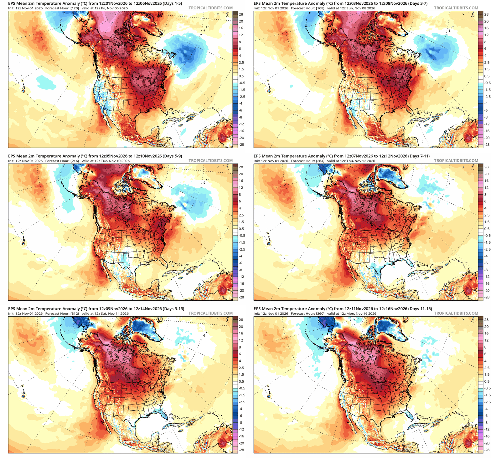
absolutely wild for November
-
Are your hydrangeas looking similar to that ? Fresh, flowering , ready
-

Mid-Long Range Discussion 2026
WinstonSalemArlington replied to BooneWX's topic in Southeastern States
-
2026-2027 Record-breaking El Nino
SnowenOutThere replied to Stormchaserchuck1's topic in Weather Forecasting and Discussion
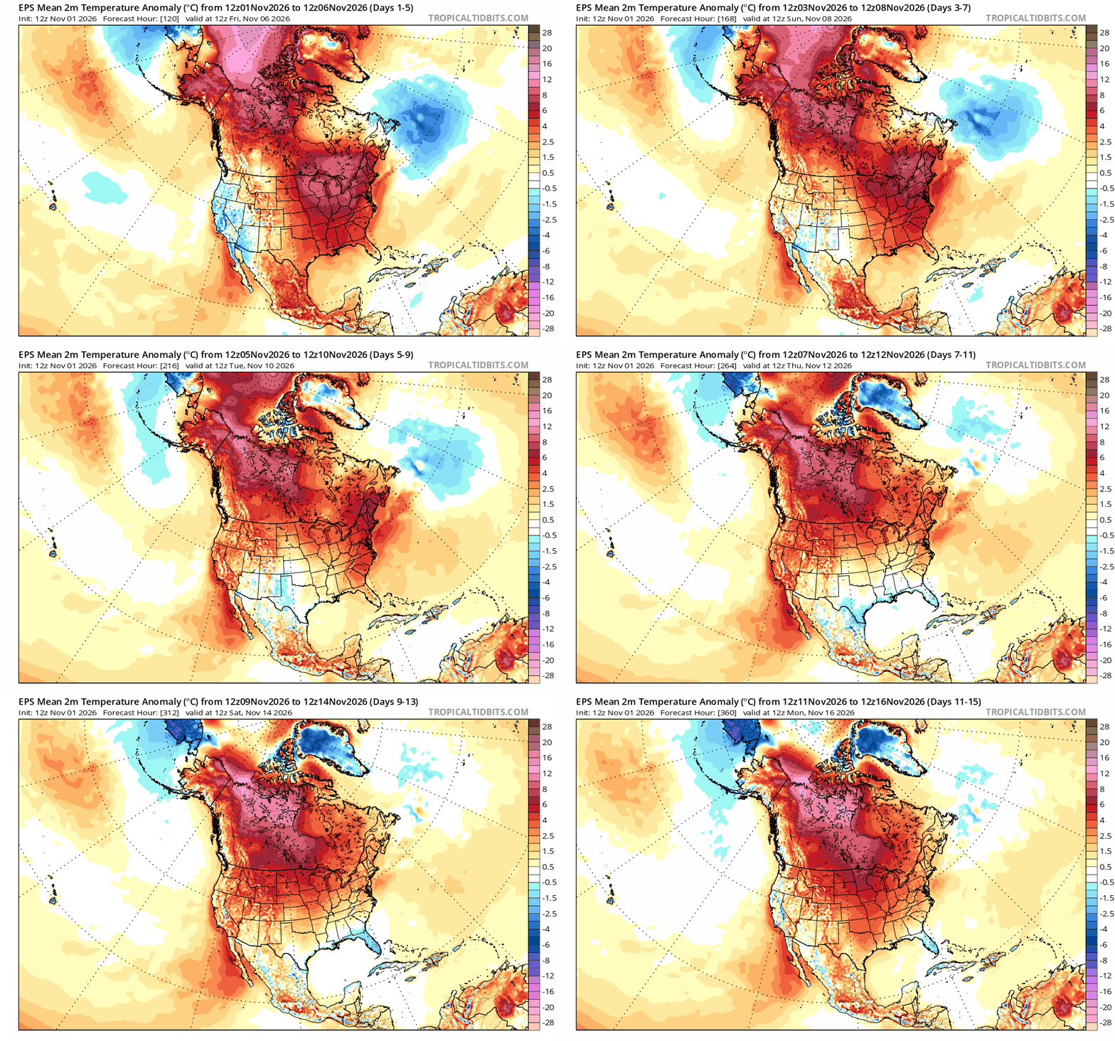
Wondered into this thread and if we're talking about the AI slop map MJO posted from Facebook then lowk it isnt even a good snow pattern. It is a cold pattern but the trough axis would be too far east to do anyone any good. You'd either get suppression based on the height lines or you would get storms which bomb out over the Atlantic ocean. You need the ULL to be behind (west) the baroclinic boundary of the gulf stream to get cyclogenesis favorable for east coast storms. -
Winter 2026-2027 Seasonal Outlook
WinstonSalemArlington replied to WinstonSalemArlington's topic in Southeastern States
-
Enough for you to get a sunburn!
-
Will you go below 50° this week after tomorrow AM?

-
Ha!!! Let's see where we are at the end of this month.
-
 http://erectamedsonline.com/# buying erectile dysfunction pills online
-
Isn't that still like -10 up there?
-
BWI: 6.0" DCA: 1.1" IAD: 5.8" RIC: T LYH: 6.6" MBY: 58" Barnes Corner NY (cabin w/@dailylurker) 188" (will receive one 48"+ LES)
-
legal online pharmacy: ApexRx Direct - foreign online pharmacy
-
erectile dysfunction medication online [url=http://erectamedsonline.com/#]ErectaMedsOnline[/url] where to buy ed pills
-

Fall 2026 Medium/Long Range Pattern Thread
jaxjagman replied to John1122's topic in Tennessee Valley
Most rains we got here in a few months,its not going to beat down the drought,the next system should even be more stronger,more like a neutral tilted trough than negative,either way the LLJ is being shown to be much stronger so convectiion could help out next week,dont look severe,failry piss poor lapse rates -
2026-2027 Fall/Winter Mountain Thread
Met1985 replied to BlueRidgeFolklore's topic in Southeastern States
Today was the freaking perfect Fall day. Had a high of 51 degrees and a low of 44 degrees. Current temp of 48. -
BWI: 5” DCA: 1” IAD: 3” RIC: 0" Tiebreaker SBY: 2"
-
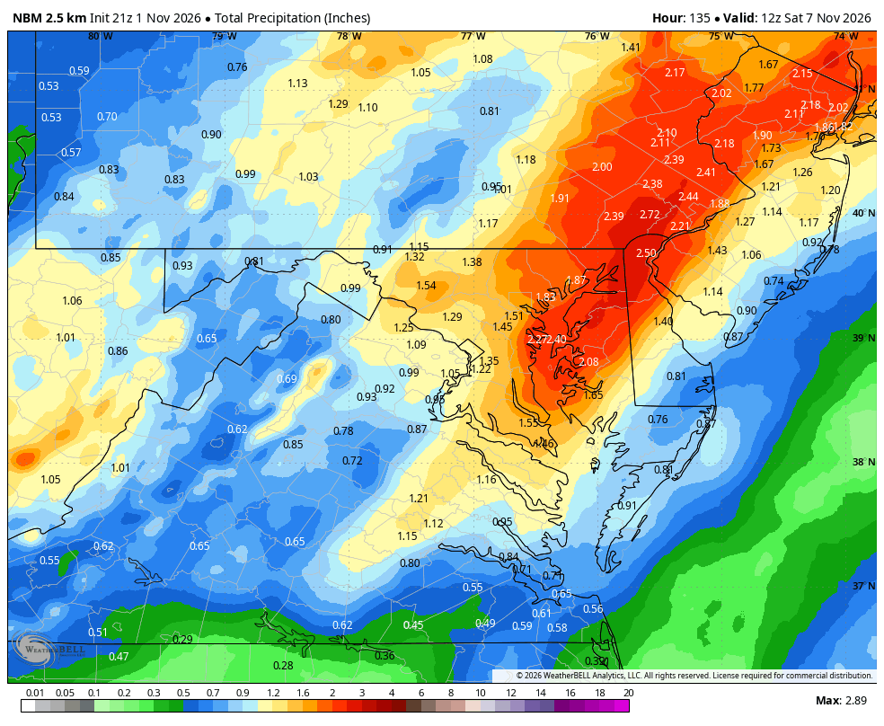
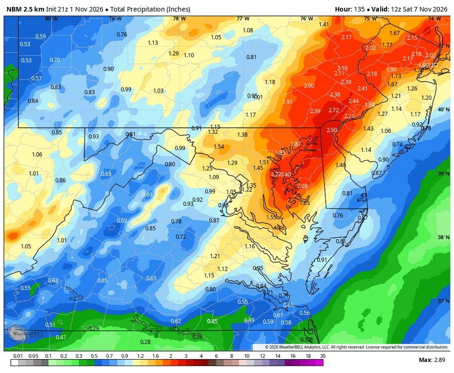
WB 21Z NBM precip. totals for late week.
-
let's build that snowpack where we need it
-
We lucked into one storm. Statistically it was an above average winter.
- Today
-

2026-2027 Record-breaking El Nino
mitchnick replied to Stormchaserchuck1's topic in Weather Forecasting and Discussion
Amen brother, Amen! -
Something isn’t right here, we’re gonna find out ENSO is like a big horseshoe and giga Ninos behave like a strong La Nina.
-

2026-2027 Record-breaking El Nino
GaWx replied to Stormchaserchuck1's topic in Weather Forecasting and Discussion
I have to give credit where credit is due. After nearly 4 hours, every post ITT including this one has been about a random way, way out in super lala land Euro control map. That has to be a record for an hour 912 map! That’s one amazing map to command this much attention! On a related note, Happy go back to Standard Time day! I love it for getting Euro Weeklies, 0Z Euro, and all models an hour earlier more than for anything else! I mean we’re only 3 hours from the start of the 0Z GFS! -
I don’t like hyperbole early on, but I think I would be fairly shocked if the mountains get near normal snowfall this winter on composite super Nino years. Thats not to say it won’t snow, heck 235” on Mansfield is below normal. But it feels like the deck is stacked a bit, especially if it’s a slow start. It takes making up some good ground to make up for struggles in even Nov/Dec when you need to hit even monthly normal totals in Jan/Feb/Mar. Now, for NNE as a whole? The lower climo snowfall areas near population centers can rely more on several good synoptic events to get closer to normal. I think my fear up here is the daily light events struggle if it’s warm, and the 2-6” type stuff that adds up over time creates a deficit.
-
prescribed antibiotics online [url=https://antibiofastdirect.com/#]AntiBio Fast Direct[/url] buy antibiotics over the counter