All Activity
- Past hour
-

E PA/NJ/DE Autumn 2025 Obs/Discussion
Albedoman replied to PhiEaglesfan712's topic in Philadelphia Region
snow weenie amounts of 4-6+inches of snow and or .25 inch of ice for 2-3 runs with DR No and the GFS also agreeing and within 3 days of the event will usually get a good one started in this forum. We are a long way from that now. LOL Last year, it only took winter weather advisory level events to kick one up - we are so snow starved and have been spanked and run down the beaten path with a bunch of events that tuned out to be absolutely jack. This forum is pretty much gun shy for starting storm threads by having been burned so much the last 5 years with pity storms. In the MA forum, you will roasted over the coals for jinxing their forum by starting one. LMAO -
They got the snow guns going at Wisp!
-
This one is like watching porn... https://www.jdjweatherconsulting.com/sne-14-15

-
6 days is never close enough, lol But I feel like we can at least say we may see our first flakes of the season All else is fantasy for now.
-
Several gusts near 40 mph from Garrett County east through the immediate DC/Baltimore suburbs.
-
Yeah and getting +10 before Dec 20 is almost impossible.
-
Ah geez power going in and out now. I'm glad I had all the lines on my property run underground so it's not my fault.
-

2025-2026 ENSO
donsutherland1 replied to 40/70 Benchmark's topic in Weather Forecasting and Discussion
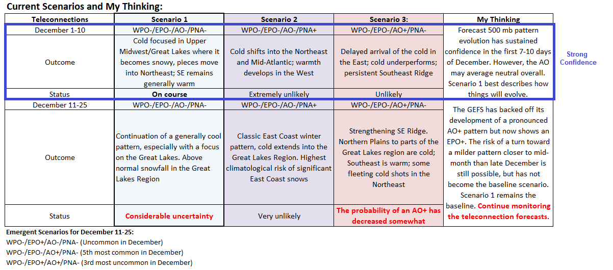
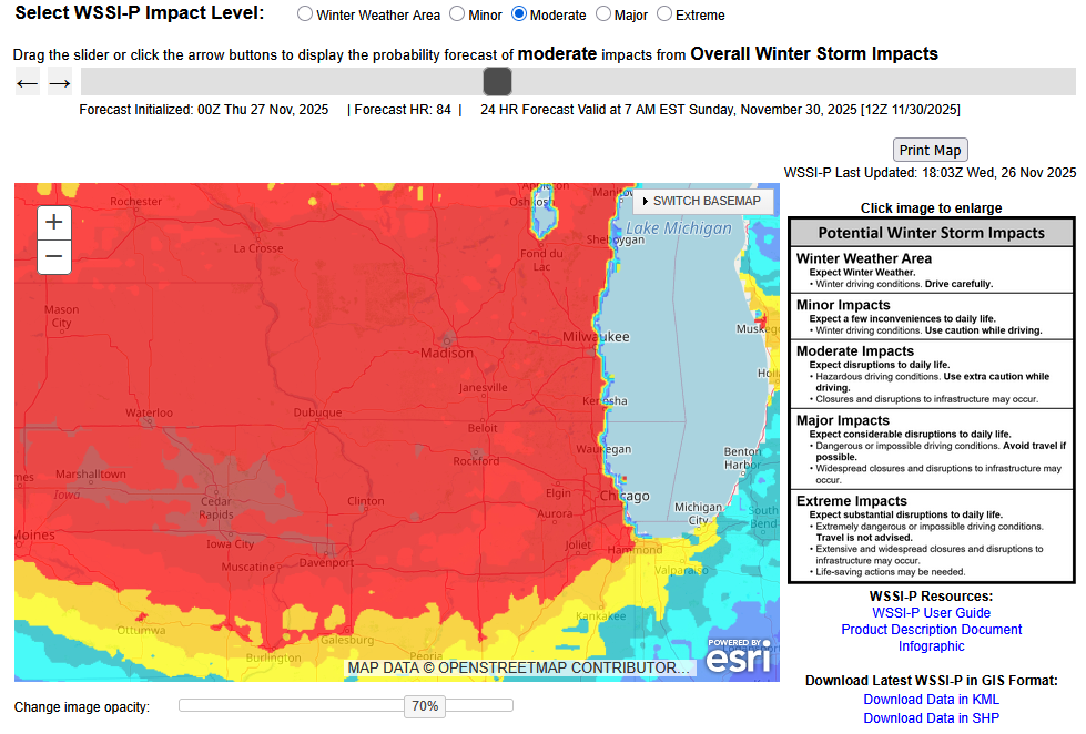
The pattern evolution for the opening 10 days of December still looks very good. With respect to the December 11-25 period, the guidance has shifted. For a time, the GEFS was showing the development of a pronounced AO+ pattern. Now, it has backed off (12z and 18z cycles). As a consequence, the baseline Scenario 1 still seems to be the best one going forward, while recognizing that there is some risk of a break near mid-month. The latest ECMWF weekly forecast largely maintains the sensible weather effects from Scenario 1. Given the shifting of the guidance, it makes sense to continue to monitor the teleconnections (and other factors) while reserving judgment for changes until later to avoid making changes based more on model noise than actual developments. Milwaukee, Chicago, Detroit, and Toronto remain in line for a snowstorm during the November 29-30 period. Significant snow is possible in Milwaukee and Chicago. A moderate snowfall looks reasonable for both Detroit and Toronto. Changes can still occur. WPC is now showing a 70% chance of a moderate winter storm impact in Chicago and surrounding areas for the 24-hour period ending November 30 7 am. Chicago remains on course to experience its snowiest fall since 2019 (8.3") and possibly even 2018 (12.7"). Milwaukee should see its snowiest fall since 2019 (13.4"). Detroit will likely experience its snowiest fall since 2021 (7.1") and possibly 2019 (9.5"). Toronto could see its snowiest fall since 2020 (23.4 cm/9.2") and perhaps 2002 (27.2 cm/10.7"). Fall 2025 Snowfall Totals (through November 26): Chicago: 1.7" Detroit: 2.2" Milwaukee: 0.6" Toronto: 12.8 cm (5.0")
-
Gale like winds on top of meadow mountain. 30F with occasional light snow right now. Wood stove going on blast.
-

December 2025 regional war/obs/disco thread
WxWatcher007 replied to Torch Tiger's topic in New England
Totally agree. I’m proceeding with extreme caution this winter but the pattern/setup looks very good at the moment for the first 1/3 of December at least. -
One thing I have learned the last 15 years being with AmericanWx..... Ji doesn't sugar coat anything!!
-
-
.thumb.jpg.ad3a2e31d30aff035044689b311a0540.jpg)
Nov 28-30th Post Turkey Day Wintry Potential
nvck replied to Chicago Storm's topic in Lakes/Ohio Valley
Scaled(54_).jpg.89693a39565f61e118f95ed43d33728e.jpg)
-
Nov 28-30th Post Turkey Day Wintry Potential
nvck replied to Chicago Storm's topic in Lakes/Ohio Valley
There is a reduction from the 12z, but relative to the 6z and 0z, looks fairly similar.gif.a0e43d02452a32850913d70e1fd54304.gif)
-
Might want to get a snow gun and make artificial snow while the getting's good!
-

Central PA Fall Discussions and Obs
canderson replied to ChescoWx's topic in Upstate New York/Pennsylvania
42 mph here -
Happy to report delightful refreshing dewpoints in the low 30s today, a delightful refreshing northerly breeze at 17mph and highs only around 60. It is so hard to believe after warm humid temps ever since late Feb. Tonight down to 38 with 30 dews. I might walk down Main St with only a soaking wet t-shirt on and swimming trunks at 3am! I might even sneak into the fish pond! Cool weather is SO INVIGORATING!
-

November 2025 general discussions and probable topic derailings ...
ORH_wxman replied to Typhoon Tip's topic in New England
If it were Christmas Eve instead of Thanksgiving Eve, the 60F isotherm would be 100 miles north. -
Yep... There are always going to be folks complaining about a particular event due to their own backyard outcome, but it's nice having a base pattern that will give trackable events for much of December...
-

Nov 28-30th Post Turkey Day Wintry Potential
beavis1729 replied to Chicago Storm's topic in Lakes/Ohio Valley
Hopefully the 18z EPS won’t show as much of a reduction in QPF…we’ll see I guess. -
It’s pretty cold in the low levels on that depiction. Pretty wide area of sleet. It’s a really sloped system. But these are details that are mostly irrelevant right now.
-
Nov 28-30th Post Turkey Day Wintry Potential
nvck replied to Chicago Storm's topic in Lakes/Ohio Valley
we can't have our cake and eat it too... -

November 2025 general discussions and probable topic derailings ...
Typhoon Tip replied to Typhoon Tip's topic in New England
This worked out reasonably well -
Down to 31 with light snow!
-
.thumb.jpg.6a4895b2a43f87359e4e7d04a6fa0d14.jpg)
Central PA Fall Discussions and Obs
Yardstickgozinya replied to ChescoWx's topic in Upstate New York/Pennsylvania
Definitely seems like we needed one with what's going down here right now. I don't know how hard the winds are blowing but they're blowing well over 25mph at this point, maybe even twice that with some of these gusts.