bwt3650 Posted December 9, 2020 Share Posted December 9, 2020 31 minutes ago, radarman said: Sparse trees on either side of Upper FIS are usually good to great. Not many turns in there, but they hold it. Cut over through the woods from the top of black diamond and it opens up. Good stuff. Link to comment Share on other sites More sharing options...
PowderBeard Posted December 9, 2020 Share Posted December 9, 2020 3 minutes ago, HoarfrostHubb said: It is brutal. Definately something you need to be in good shape for... I ain't in good shape now...lol I thought I was in decent shape in Feb-March until I started doing this. Been working out 4-5 days a week because she is now ~15 pounds heavier and I won't have many solo days. 4 Link to comment Share on other sites More sharing options...
PhineasC Posted December 9, 2020 Share Posted December 9, 2020 5 minutes ago, PowderBeard said: I thought I was in decent shape in Feb-March until I started doing this. Been working out 4-5 days a week because she is now ~15 pounds heavier and I won't have many solo days. LOL now that is dedication right there. Link to comment Share on other sites More sharing options...
radarman Posted December 9, 2020 Share Posted December 9, 2020 5 minutes ago, PowderBeard said: I have not done enough exploring at Ellen. My impulsive side gets the best of me and I find it hard to resist checking out "The Church" and rabbit holes around Castlerock each time I am there. You can't really go wrong over there either. Rumble woods accessed from the top of Middle Earth is absolute prototype steep eastern trees and small cliffs, and even the trail itself premier Vermont cut narrow moguls down the fall line. Ellen summit is a little more exposed with scrubbier trees as you pointed out. So if it's foggy or especially windy you're better off elsewhere. Also, sometimes after a big storm, they might hold off on opening Ellen an extra day. But if you hit it right, especially on a bluebird, I don't think you'll wish you had splurged on the LP ticket. 1 Link to comment Share on other sites More sharing options...
bwt3650 Posted December 9, 2020 Share Posted December 9, 2020 13 minutes ago, PowderBeard said: I thought I was in decent shape in Feb-March until I started doing this. Been working out 4-5 days a week because she is now ~15 pounds heavier and I won't have many solo days. And that’s how kids learn to ski before they can walk straight. You’ve got a powder day partner for life right there. 1 Link to comment Share on other sites More sharing options...
PowderBeard Posted December 9, 2020 Share Posted December 9, 2020 Just now, bwt3650 said: And that’s how kids learn to ski before they can walk straight. You’ve got a powder day partner for life right there. Hopefully. She staggers like a college kid leaving the bar at 2am and the 67cm skis and boots are waiting in the basement. Link to comment Share on other sites More sharing options...
bwt3650 Posted December 9, 2020 Share Posted December 9, 2020 I think my daughter was 3 1/2 working on her form there. Mom snowboards, so she wanted nothing to do with skis. 1 Link to comment Share on other sites More sharing options...
Hitman Posted December 9, 2020 Share Posted December 9, 2020 22 minutes ago, radarman said: You can't really go wrong over there either. Rumble woods accessed from the top of Middle Earth is absolute prototype steep eastern trees and small cliffs, and even the trail itself premier Vermont cut narrow moguls down the fall line. Ellen summit is a little more exposed with scrubbier trees as you pointed out. So if it's foggy or especially windy you're better off elsewhere. Also, sometimes after a big storm, they might hold off on opening Ellen an extra day. But if you hit it right, especially on a bluebird, I don't think you'll wish you had splurged on the LP ticket. I'd just add that Exterminator woods holds snow really well and there are some cliffs off the long trail to the north of there that are great but you need to know where you're going because the pines in there are really thick. 1 Link to comment Share on other sites More sharing options...
tamarack Posted December 9, 2020 Share Posted December 9, 2020 58 minutes ago, radarman said: The woods skiers left of Black diamond holds literally like 1-2 lines, but it's frickin chest deep in there... And the other side ain't bad either Nothing whatsoever against LP, but I have a special fondness for the Ellen summit. I think it's overlooked sometimes. I learned parallel at the old Glen Ellen many years ago, on a super cheap January ski week - including gas, meals and lodging I barely cracked $100. A year later I returned as an intermediate skier and chickened out on the summit, taking the long way around rather than Upper FIS. Then I tried the narrow and twisty black diamond just left of the lower liftline and had a great run - conditions were excellent. That told me that the much steeper/much wider FIS was within my reach, but unfortunately we had to head home to NNJ after that run. (And the real scary trail that I'd never had tried was then called Scotch Mist, down the summit liftline - steep as FIS but narrow and with hard objects in the middle. 1 Link to comment Share on other sites More sharing options...
HoarfrostHubb Posted December 9, 2020 Share Posted December 9, 2020 47 minutes ago, PowderBeard said: I thought I was in decent shape in Feb-March until I started doing this. Been working out 4-5 days a week because she is now ~15 pounds heavier and I won't have many solo days. That's fantastic. That ship has sailed for me many years ago Link to comment Share on other sites More sharing options...
radarman Posted December 9, 2020 Share Posted December 9, 2020 23 minutes ago, tamarack said: I learned parallel at the old Glen Ellen many years ago, on a super cheap January ski week - including gas, meals and lodging I barely cracked $100. A year later I returned as an intermediate skier and chickened out on the summit, taking the long way around rather than Upper FIS. Then I tried the narrow and twisty black diamond just left of the lower liftline and had a great run - conditions were excellent. That told me that the much steeper/much wider FIS was within my reach, but unfortunately we had to head home to NNJ after that run. (And the real scary trail that I'd never had tried was then called Scotch Mist, down the summit liftline - steep as FIS but narrow and with hard objects in the middle. Cool. Scotch Mist is now called Black Diamond. Makes you wonder why they changed it. Kind of like they changed my town name from the perfectly nice Cold Spring to, well... nvm. I presume the twisty diamond you mention is Lower FIS, and that's also just a wonderful long pleasant mogul run. The short hike out at the bottom tends to keep the crowds away so you can save it for later and still find fresh tracks late morning. Link to comment Share on other sites More sharing options...
Angus Posted December 9, 2020 Share Posted December 9, 2020 On a weekend when both Sugarbush and Glen Ellen are open, I stick to GE b/c crowds are substantially less and there is a lot of fun terrain over there. The area on the Glen Ellen summit is a lot of fun. Castlerock terrain is great - but on a weekend, the lift is brutal. On a weekday, I will spend 75% of my time skiing castlerock and poking around terrain off ripcord lift - organgrinder, paradise, et cetera. Link to comment Share on other sites More sharing options...
Hitman Posted December 9, 2020 Share Posted December 9, 2020 31 minutes ago, radarman said: Cool. Scotch Mist is now called Black Diamond. Makes you wonder why they changed it. Kind of like they changed my town name from the perfectly nice Cold Spring to, well... nvm. I presume the twisty diamond you mention is Lower FIS, and that's also just a wonderful long pleasant mogul run. The short hike out at the bottom tends to keep the crowds away so you can save it for later and still find fresh tracks late morning. I love black diamond. Also, the woods between Tumbler and lower FIS are fun. Link to comment Share on other sites More sharing options...
MRVexpat Posted December 9, 2020 Share Posted December 9, 2020 45 minutes ago, Hitman said: I'd just add that Exterminator woods holds snow really well and there are some cliffs off the long trail to the north of there that are great but you need to know where you're going because the pines in there are really thick. Those cliffs are something of a white whale for me. Of all the known and unknown tree shots along the monroe skyline, thats the one I never figured out. Tried it once and ended up going too far (I think). Had a couple of super steep turns down a barely skiable chute before doing the wiggle in flat pines before I hit the northway cutover about 1/3 of the way to inverness. One day! My personal favorite is longtrail north of castlerock and then drop in right over the ridge into slidebrook. Entrance is tough to find but boy is it worth it. That's all I'll say A nice view followed by 2k vert of tree chutes to the cat track under the slidebrook lift line. 2 Link to comment Share on other sites More sharing options...
tamarack Posted December 9, 2020 Share Posted December 9, 2020 45 minutes ago, radarman said: Cool. Scotch Mist is now called Black Diamond. Makes you wonder why they changed it. Kind of like they changed my town name from the perfectly nice Cold Spring to, well... nvm. I presume the twisty diamond you mention is Lower FIS, and that's also just a wonderful long pleasant mogul run. The short hike out at the bottom tends to keep the crowds away so you can save it for later and still find fresh tracks late morning. Not lower FIS, but left of the Mountain lift (Glen Ellen's name for the long sl-o-o-w lift from the base) as one looks downhill. Most trail names there had a Scotch motif, with names like Black Watch, Inverness and Hoot Mon. Got onto the last by accident (missed the beginner trail turnoff) my first morning of ski week but before the classes were assigned and it was a disaster for someone barely past the snowplow - advanced intermediate with icy moguls and slabby powder in the hollows. I probably fell 20 times and the remaining $80 in Travelers Checks were left behind sometime during the process. However, it worked out okay, as I was initially placed in advanced stem but there too many, so they asked if anyone had been up the Mountain lift that morning and the 2 of us got bumped up to beginning parallel. 1 Link to comment Share on other sites More sharing options...
Angus Posted December 9, 2020 Share Posted December 9, 2020 to put it into perspective - I might average 1 or 2 days at SB as a day tripper/maybe an overnight (some combo of SB, BV, Stowe and MRG) but as such never skied Slidebrook area given 'time' was a scarce commodity. With that said, I doubt I will ski at SB anytime soon given I've gone with the Epic pass which is too bad. I use to buy the 4 pack discount ticket package. Link to comment Share on other sites More sharing options...
MRVexpat Posted December 9, 2020 Share Posted December 9, 2020 5 minutes ago, tamarack said: Not lower FIS, but left of the Mountain lift (Glen Ellen's name for the long sl-o-o-w lift from the base) as one looks downhill. Most trail names there had a Scotch motif, with names like Black Watch, Inverness and Hoot Mon. Got onto the last by accident (missed the beginner trail turnoff) my first morning of ski week but before the classes were assigned and it was a disaster for someone barely past the snowplow - advanced intermediate with icy moguls and slabby powder in the hollows. I probably fell 20 times and the remaining $80 in Travelers Checks were left behind sometime during the process. However, it worked out okay, as I was initially placed in advanced stem but there too many, so they asked if anyone had been up the Mountain lift that morning and the 2 of us got bumped up to beginning parallel. I believe you may be talking about what is currently known as Hammerhead, not sure about former names though. Link to comment Share on other sites More sharing options...
tamarack Posted December 9, 2020 Share Posted December 9, 2020 8 minutes ago, MRVexpat said: I believe you may be talking about what is currently known as Hammerhead, not sure about former names though. That's the one, and Hoot Mon is now The Brambles. Also noted The Cliffs is now single diamond - used to be advanced intermediate but with the "s" added to the name I guess it's more difficult. 1 Link to comment Share on other sites More sharing options...
Hitman Posted December 9, 2020 Share Posted December 9, 2020 28 minutes ago, tamarack said: That's the one, and Hoot Mon is now The Brambles. Also noted The Cliffs is now single diamond - used to be advanced intermediate but with the "s" added to the name I guess it's more difficult. I hate Hammerhead. there's just something funky such that the bumps never seem to line up right. Link to comment Share on other sites More sharing options...
Hitman Posted December 9, 2020 Share Posted December 9, 2020 1 hour ago, MRVexpat said: Those cliffs are something of a white whale for me. Of all the known and unknown tree shots along the monroe skyline, thats the one I never figured out. Tried it once and ended up going too far (I think). Had a couple of super steep turns down a barely skiable chute before doing the wiggle in flat pines before I hit the northway cutover about 1/3 of the way to inverness. One day! I think you were there. The cliffs are skiers left of that chute. Its just that the pines are so thick you can ski right past without seeing them. and that chute is nasty. 2 Link to comment Share on other sites More sharing options...
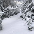
J.Spin Posted December 9, 2020 Share Posted December 9, 2020 4 hours ago, PhineasC said: Walking up a ski slope and then skiing down sounds downright exhausting, not gonna lie. LOL Phin, I’m pretty sure I’ve heard you say you go hiking with the kids! Sure, boot-packing up a steep slope with your skis over your shoulder through two feet of powder would definitely end up being more work that a typical hike, but most of the time that’s not how we’re doing it. When ascending with skins, a round trip up the mountain and down is actually less effort than an equivalent hike on a typical hiking trail. With a pre-made skin track or a groomed slope, proper skinning technique, and an appropriate ascent angle, climbing snow on skis is actually easier than hiking. You’re not carrying your skis; when you’re skinning, you just lift your foot slightly take the pressure off your ski to allow it to slide, then repeat to take the next step. On a typical packed surface, ascending on snow via skins is easier than hiking because the surface is flat and consistent, and you don’t need to expend extra energy negotiating trail obstacles, picking foot placement, etc., etc. And then the down… LOL. As long as you’re a competent skier, it’s literally an order of magnitude less effort/easier than hiking down. In terms of energy usage, skiing down a mountain is like putting your car in neutral and cruising with gravity. In contrast, hiking down a mountain is the equivalent of applying your car’s brakes, and then revving the engine way up to overcome the application of the brakes so that you can move at a regular speed. It’s hugely counterproductive, and a massive waste of all the potential energy that you just earned by ascending. And, the above comparison doesn’t even take into account the powder aspect. Most often, we go ski touring so that we can ski untouched powder on the descent. So instead of just skiing down, you’re descending the mountain as if you were floating on a cloud. A descent that was already incredibly easy, is now made ridiculously easy and hugely enjoyable. Oh, and as if that wasn’t already enough, there’s the additional aspect of often having the entire trail to yourself. Now there is one caveat to this – powder skiing is only easier than groomed skiing if you’re a competent powder skier. If you’re not proficient at skiing powder, then it can actually be more work than skiing groomed terrain. There’s an easy fix for that though… just learn to ski powder. If you’re already a good powder skier then you know what I mean, and if not, well you literally live in the mountains of NNE, so you can ski a lot of powder if you want and get really good at skiing it. My wife and I hiked Mansfield with the boys this fall, and it was a roughly 3,000’ vertical hike. For whatever reason, the downhill was especially brutal that day. I still hike, but ski touring has kind of ruined plain hiking for me somewhat because the touring is just so much more enjoyable and requires much less effort. So while it may seem exhausting, it’s actually not if done efficiently, and of course the result is days like this: 2 Link to comment Share on other sites More sharing options...
PhineasC Posted December 9, 2020 Share Posted December 9, 2020 1 minute ago, J.Spin said: LOL Phin, I’m pretty sure I’ve heard you say you go hiking with the kids! Sure, boot-packing up a steep slope with your skis over your shoulder through two feet of powder would definitely end up being more work that a typical hike, but most of the time that’s not how we’re doing it. When ascending with skins, a round trip up the mountain and down is actually less effort than an equivalent hike on a typical hiking trail. With a pre-made skin track or a groomed slope, proper skinning technique, and an appropriate ascent angle, climbing snow on skis is actually easier than hiking. You’re not carrying your skis; when you’re skinning, you just lift your foot slightly take the pressure off your ski to allow it to slide, then repeat to take the next step. On a typical packed surface, ascending on snow via skins is easier than hiking because the surface is flat and consistent, and you don’t need to expend extra energy negotiating trail obstacles, picking foot placement, etc., etc. And then the down… LOL. As long as you’re a competent skier, it’s literally an order of magnitude less effort/easier than hiking down. In terms of energy usage, skiing down a mountain is like putting your car in neutral and cruising with gravity. In contrast, hiking down a mountain is the equivalent of applying your car’s brakes, and then revving the engine way up to overcome the application of the brakes so that you can move at a regular speed. It’s hugely counterproductive, and a massive waste of all the potential energy that you just earned by ascending. And, the above comparison doesn’t even take into account the powder aspect. Most often, we go ski touring so that we can ski untouched powder on the descent. So instead of just skiing down, you’re descending the mountain as if you were floating on a cloud. A descent that was already incredibly easy, is now made ridiculously easy and hugely enjoyable. Oh, and as if that wasn’t already enough, there’s the additional aspect of often having the entire trail to yourself. Now there is one caveat to this – powder skiing is only easier than groomed skiing if you’re a competent powder skier. If you’re not proficient at skiing powder, then it can actually be more work than skiing groomed terrain. There’s an easy fix for that though… just learn to ski powder. If you’re already a good powder skier then you know what I mean, and if not, well you literally live in the mountains of NNE, so you can ski a lot of powder if you want and get really good at skiing it. My wife and I hiked Mansfield with the boys this fall, and it was a roughly 3,000’ vertical hike. For whatever reason, the downhill was especially brutal that day. I still hike, but ski touring has kind of ruined plain hiking for me somewhat because the touring is just so much more enjoyable and requires much less effort. So while it may seem exhausting, it’s actually not if done efficiently, and of course the result is days like this: Appreciate the detailed info, as usual. I am not very familiar with this uphill stuff at all because it just doesn’t exist down south as far as I am aware. Or if it does the community is much smaller and unknown to me. I pictured you guys trudging up thousands of vertical feet in waist-high snow and was pretty confused as to how that was fun. LOL Sounds like skinning takes a little finesse and technique but once you have it down it makes the work easier. Definitely did plenty of hiking with the kids before the snow set in. We are slowly working our way up Madison in each hike, going a bit further each time. Takes time with the 4 and 6 year old but they love to see the progress. Link to comment Share on other sites More sharing options...
MRVexpat Posted December 9, 2020 Share Posted December 9, 2020 8 minutes ago, PhineasC said: Appreciate the detailed info, as usual. I am not very familiar with this uphill stuff at all because it just doesn’t exist down south as far as I am aware. Or if it does the community is much smaller and unknown to me. I pictured you guys trudging up thousands of vertical feet in waist-high snow and was pretty confused as to how that was fun. LOL Sounds like skinning takes a little finesse and technique but once you have it down it makes the work easier. Definitely did plenty of hiking with the kids before the snow set in. We are slowly working our way up Madison in each hike, going a bit further each time. Takes time with the 4 and 6 year old but they love to see the progress. If you ever get the equipment (or even snowshoes), I can certainly recommend the GBA crescent ridge glades that are literally right behind your property. You couldn't have a more perfect place to understand why everyone these days is so hooked on self powered skiing. Its a casual half mile to a mile approach that opens up into a mellow field that's perfect for practicing skiing soft snow, though if its deep you'll want some more pitch which you can find by following the prescribed skin track to the ridge. From there you have 3 or 4 lines that are the equivalent of skiing a black diamond glade at a resort, but often with much better conditions! https://granitebackcountryalliance.org/crescent-ridge-glade 1 Link to comment Share on other sites More sharing options...
powderfreak Posted December 9, 2020 Share Posted December 9, 2020 On 12/8/2020 at 4:26 PM, MRVexpat said: I mean I still think there is a notion of north to south decrease in upslope snow, it may just be a question of diminishing difference as you head south. Strictly anecdotally speaking, if Jay is the high water mark in orographic snows, I imagine Stowe/Smuggs get 80-90% of that, Sugarbush/MRG 45-55%, Killington 25% and areas south of there roughly 15-20% of Jay's total. Of course this is broad brushed and can differ season by season and I'm also sure that among the So VT resorts, distance from the spine plays a part but generally speaking this is always how I've thought of it/observed. The bolder I agree with. It’s not as big of a difference as up north, but I truly believe there is still a north/south gradient between Mt Snow and Killington. Marginal borderline events, maybe SWFE? Killington has significant elevation in that 2000-4000ft range, slightly higher than Mt Snow. I get @radarman’s point though, sometimes Mt Snow gets hit hard in coastal that scrape Killington... but my gut still says there’s a gradient between the two. Link to comment Share on other sites More sharing options...
radarman Posted December 9, 2020 Share Posted December 9, 2020 FWIW, Killington reported 3" today. Mt Snow snowed lightly most of the day but the cam on the stake really only shows like a half inch, maybe a little more. Sugarbush reported 2". Radar did look decent over Killington. Link to comment Share on other sites More sharing options...
powderfreak Posted December 9, 2020 Share Posted December 9, 2020 8 minutes ago, radarman said: FWIW, Killington reported 3" today. Mt Snow snowed lightly most of the day but the cam on the stake really only shows like a half inch, maybe a little more. Sugarbush reported 2". Radar did look decent over Killington. Yeah Killington looked favored on that blocked SW flow ahead of the low today. We had 1.5" daytime at Stowe... the same I got down in the village. There's an insane amount of rime up on the hill from the thick moist clouds. The hill is plastered white, despite low natural snow depths. Some terrain expansion coming. 3 Link to comment Share on other sites More sharing options...
PowderBeard Posted December 10, 2020 Share Posted December 10, 2020 2 hours ago, powderfreak said: The bolder I agree with. It’s not as big of a difference as up north, but I truly believe there is still a north/south gradient between Mt Snow and Killington. I would think east-west would matter in SVT but its the direct opposite of what I thought for down there. A sample other than ski areas, Dorset and Equinox average only 90-100" a year according to the google machine. Always figured it would be much more, radar always seems lit up in that area even during the weaker flows. Link to comment Share on other sites More sharing options...
PowderBeard Posted December 10, 2020 Share Posted December 10, 2020 15 hours ago, powderfreak said: Yeah Killington looked favored on that blocked SW flow ahead of the low today. We had 1.5" daytime at Stowe... the same I got down in the village. There's an insane amount of rime up on the hill from the thick moist clouds. The hill is plastered white, despite low natural snow depths. Some terrain expansion coming. Upper LL looks good to go and afterwards you can turn your sticks into shot-skis or a chair. 1 Link to comment Share on other sites More sharing options...
backedgeapproaching Posted December 10, 2020 Share Posted December 10, 2020 14 hours ago, PowderBeard said: I would think east-west would matter in SVT but its the direct opposite of what I thought for down there. A sample other than ski areas, Dorset and Equinox average only 90-100" a year according to the google machine. Always figured it would be much more, radar always seems lit up in that area even during the weaker flows. I guess you are meaning lower elevations---you probably know Mt Equinox goes up to almost 4K. They certainly average over 100" above 2K in the Taconic's of SVT. No one lives above 1500' in the Taconic side of SVT, so hard to get any iron clad evidence of snowfall. There are few guys I loosely know that do some back country skiing in the Taconic's west of Manchester, have no idea where exactly. You are right that the Taconic's and Mt Equinox do pretty well on W/NW somewhat blocked uplsope flow. They can block some of that moisture from getting over to the Greens and Stratton, Bromley, etc at times and can relatively clean up while those areas get less. They don't do as well with strong E/SE obviously and they also can really torch, and have really bad retention--even the high elevations you can see melt out quickly at times say compared to much lower elevations east of the Greens. Have always wondered why they never put in some type of ski area on Mt Equinox-- I mean you would have almost 3K of pretty steep vertical right down into the west side of Manchester. I'm sure there were some political wrangling's going on over the decades that had a part in it. Link to comment Share on other sites More sharing options...
PowderBeard Posted December 10, 2020 Share Posted December 10, 2020 10 minutes ago, backedgeapproaching said: I guess you are meaning lower elevations---you probably know Mt Equinox goes up to almost 4K. They certainly average over 100" above 2K in the Taconic's of SVT. No one lives above 1500' in the Taconic side of SVT, so hard to get any iron clad evidence of snowfall. There are few guys I loosely know that do some back country skiing in the Taconic's west of Manchester, have no idea where exactly. You are right that the Taconic's and Mt Equinox do pretty well on W/NW somewhat blocked uplsope flow. They can block some of that moisture from getting over to the Greens and Stratton, Bromley, etc at times and can relatively clean up while those areas get less. They don't do as well with strong E/SE obviously and they also can really torch, and have really bad retention--even the high elevations you can see melt out quickly at times say compared to much lower elevations east of the Greens. Have always wondered why they never put in some type of ski area on Mt Equinox-- I mean you would have almost 3K of pretty steep vertical right down into the west side of Manchester. I'm sure there were some political wrangling's going on over the decades that had a part in it. It did not say where but even measuring at the base I would assume more than 98" a year at Equinox,. I doubt it is the true base of the auto road because that is several hundred feet lower than Manchester but would get an extra ~30". If Stratton gets about 180" I would assume both of those would get over 200". Link to comment Share on other sites More sharing options...

Recommended Posts
Create an account or sign in to comment
You need to be a member in order to leave a comment
Create an account
Sign up for a new account in our community. It's easy!
Register a new accountSign in
Already have an account? Sign in here.
Sign In Now