hudsonvalley21
-
Posts
4,276 -
Joined
-
Last visited
Content Type
Profiles
Blogs
Forums
American Weather
Media Demo
Store
Gallery
Everything posted by hudsonvalley21
-
Just to the south and west is Storm King mtn. There too it goes up over 1k in spots. Could have issues there also.
-
January 2021 temperature forecast contest
hudsonvalley21 replied to Roger Smith's topic in Weather Forecasting and Discussion
DCA: +3.8 NYC +3.7 BOS: +3.9 ORD: +2.6 ATL: +1.9 IAH: +0.7 DEN: +0.6 PHX: +1.0 SEA: +1.9 -
Quick coating here too. What a swing, roughly a 30 degree temperature drop in 24 hours. Total of 2.13 in the bucket for the rain portion of this event. Ending this Christmas Day as a white Christmas
-
1.87 here.
-
Merry Christmas to you and yours.
-
Merry Christmas
-
Merry Christmas and totally agree on the new radar.
-
Glad to hear all is good from last night. Merry Christmas to you and yours!
-
Feeling blessed with not loosing power or having any damage. So far 1.84 in the bucket. Not a sign of any snow from last week’s event. Hope you faired as well. merry Christmas to you and yours.
-
Heavy rain now and sustained winds around 20 with gusts around 40. 0.47 in the bucket so far 58/57
- 242 replies
-
- 1
-

-
- damaging wind
- flooding rains
- (and 1 more)
-
Same here, hopefully there will be a few snow piles leftover to see tomorrow morning. 55/53
-
?
-
12 here currently
-
Yea it wasn’t the depth it was the density
-
Had some real crappy flakes here too. Snow was real dense and and like packed powder. Could be from the winds destroying the dendrites
-
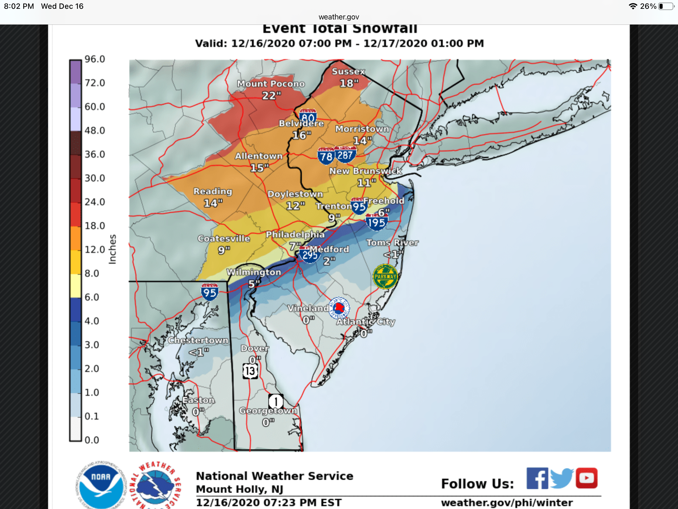
December 16-17, 2020 Storm Observations and Nowcast
hudsonvalley21 replied to wdrag's topic in New York City Metro
10.7 is the final here. -
10.7 will do it here. very impressive amounts as per the snow reports at NWS KBGM. 10” was enough to remove, screw 30+
-
At 6” currently. We’ll see what happens overnight.
-
Just had a lightning flash and a rumble of thunder.
-
Flakes improving and back to mostly snow. Wind gusts are getting more frequently now.
-
Uptown’s AFD has some of that mid level information. It could be that it’s pushing much further north than thought. NEAR TERM /THROUGH THURSDAY/... Strong thermal forcing overrunning a 1037mb polar high centered over eastern Canada, bleeding southward into southern New England, has resulted in 2-3 inches of snow across portions of the NYC metro, NE NJ, and Long Island, with snowfall rates of 1-2 inches an hour. This activity will overspread CT and the Lower Hudson Valley the next couple of hours as cold, dry air (dew points in the single digits to lower teens) saturates. Thus far, the NAMNest, the warmer of the solutions aloft, was handling the thermo profile best when compared to the 00Z OKX sounding. It was around 0c at 825mb, while the GFS and HRRR were several degrees cooler. Strong lift though will keep this area generally isothermal and below freezing the next few hours. The key here will be the position of the coastal front and how far north and west the warm nose (around 750 mb) gets overnight. There is even some evidence that the boundary layer will warm sufficiently after midnight (due to east winds) for some rain across eastern sections of Long Island and perhaps coastal SE CT. The front end dump of snow may make this a moot point with warning level snows likely achieved before this changeover even happens later tonight. Greatest pressure falls of 7mb in the last 3 hours just east of the Delmarva with a 1004 mb low east Wallops Island, VA. The low will continue to track northward and hug the coast, as a negatively tilted shortwave trough works NE across the central Appalachians. The low will eventually turn east running into the blocking high over eastern Canada, passing south of Long Island overnight into Thursday morning. The primary question remains how far north the low will come before making its eastward turn, which in turn dictates how much, if any, warm air is able to work into the area at the surface and aloft. From a big picture perspective, the models have been very consistent with the position of the low over the past 24 hours, with only minor changes from run to run. However, given how close the low is forecast to come to the region, even minor changes in the location of the low will have a significant impact on snowfall totals, especially along the coast. In addition, high resolution models are indicating the potential for a dry slot to develop across Long Island and perhaps as far north as southern Connecticut. Model soundings also indicate some loss of saturation in the dendritic growth zone during this same period, all of which could at the very least limit the intensity of precipitation, and possibly allow precipitation to change to drizzle for a period. With that said, global model soundings remain below freezing throughout the event, keeping precipitation all snow. Winds will become more northerly as the low pulls east towards daybreak, which will allow colder air to filter back into the region, changing precipitation back to snow everywhere. Snow will eventually wrap up from west to east from late morning into the early afternoon. Snowfall accumulations will range from 12-18 inches across the Lower Hudson Valley, interior northeast New Jersey, and interior southwestern Connecticut, where precipitation will remain all snow. Snow totals will range from 10-15 inches across much of the New York City metro area and western Long Island, although totals could be a few inches lower across coastal portions of Brooklyn, Queens, and Nassau County. Across the rest of Long Island and far southeastern Connecticut, snowfall totals will range from 4-12 inches, lowest across the Twin Forks and immediate south facing coastlines.
-
Same here but at 4”
-
December 16-17, 2020 Storm Observations and Nowcast
hudsonvalley21 replied to wdrag's topic in New York City Metro
2.75 OTG with SN+. Moderate sized flakes and good dendritic quality. 20/19. Must be 10: to 12:1 ratios. -
I was thinking that and or possibly it has mixing in this run