hudsonvalley21
-
Posts
4,276 -
Joined
-
Last visited
Content Type
Profiles
Blogs
Forums
American Weather
Media Demo
Store
Gallery
Everything posted by hudsonvalley21
-
Hopefully I can cheer you up.
-
Maybe some thundersnow?
-
Impressive
-
Picked up in intensity now 22/18. Dew point jumping up 5 in the last hour.
-
Any changes in accumulations
-
Light snow just started
-
18z 3k NAM puts me in a snow hole
-
La La lock it up
-
December 16-17, 2020 Storm Observations and Nowcast
hudsonvalley21 replied to wdrag's topic in New York City Metro
Pretty much on schedule -
December 16-17, 2020 Storm Observations and Nowcast
hudsonvalley21 replied to wdrag's topic in New York City Metro
23/13 nothing yet. Need just a little more saturation. -
December 16-17, 2020 Storm Observations and Nowcast
hudsonvalley21 replied to wdrag's topic in New York City Metro
I jumped to 12 -
December 16-17, 2020 Storm Observations and Nowcast
hudsonvalley21 replied to wdrag's topic in New York City Metro
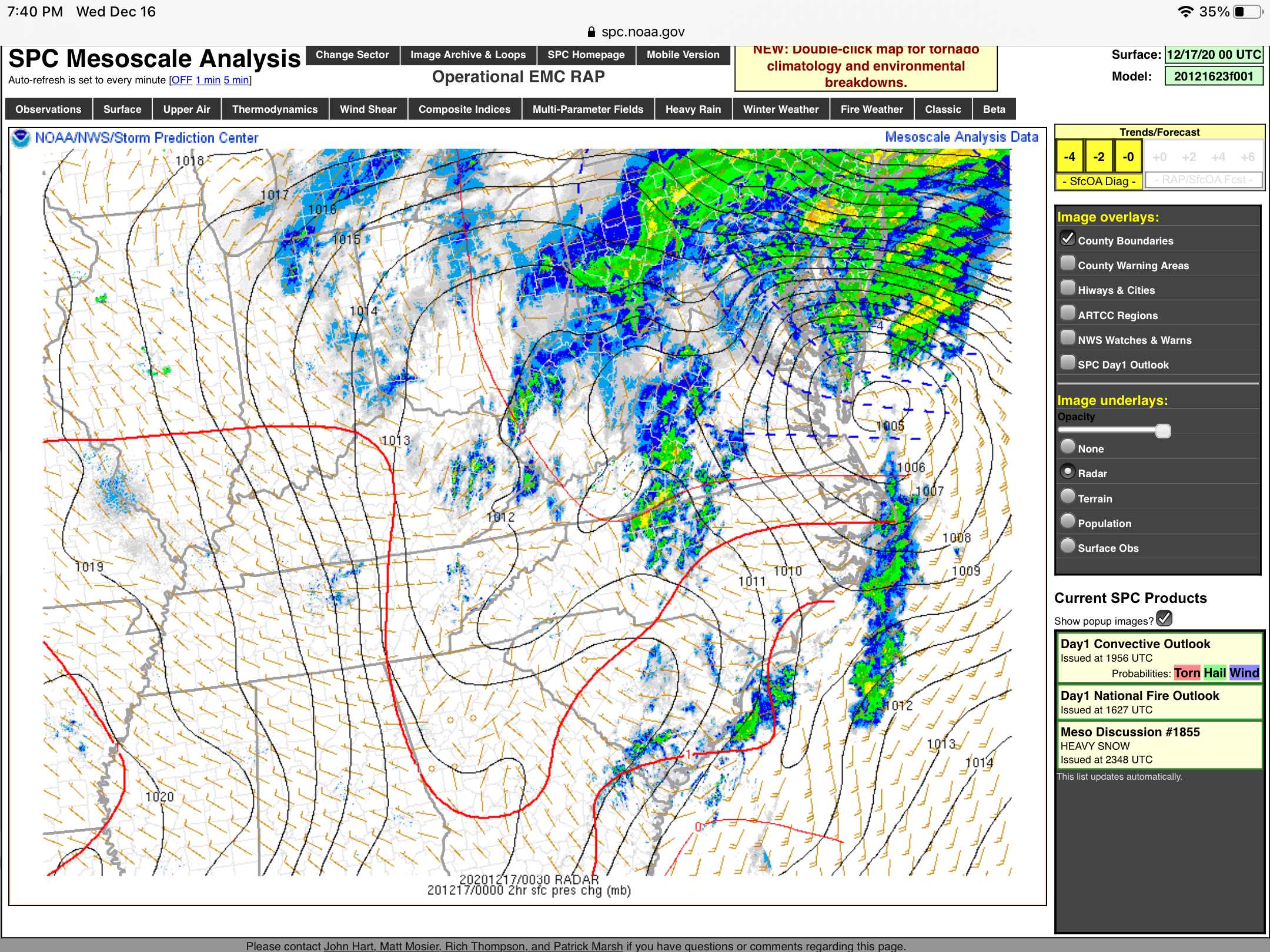
Current dew points in the metro area and north of the city. CITY SKY/WX TMP DP RH WIND PRES REMARKS Central Park CLOUDY 31 17 56 NE12G18 30.31F WCI 22 Bronx Lehman C N/A 30 10 43 E13 N/A WCI 20 LaGuardia Arpt CLOUDY 33 19 56 NE23 30.31F WCI 21 Queens College N/A 32 18 55 NE15 N/A WCI 22 Kennedy Intl CLOUDY 31 16 54 NE17 30.30F WCI 19 Breezy Point NOT AVBL Brooklyn Coll N/A 32 18 55 NE9 N/A WCI 24 Staten Island N/A 32 19 59 NE12 N/A WCI 23 Newark/Liberty CLOUDY 32 17 54 NE16 30.30F WCI 21 Teterboro CLOUDY 28 9 44 NE9 30.31F WCI 19 $$ White Plains CLOUDY 26 0 32 NE13G20 30.30F WCI 15 Larchmont Harb N/A N/A N/A N/A N21 N/A Croton On Huds N/A N/A N/A N/A E5 N/A Somers N/A 27 7 43 NE3 N/A Brewster N/A 25 3 39 NE5 N/A WCI 19 Newburgh CLOUDY 23 10 58 NE12 30.35F WCI 12 Montgomery PTSUNNY 21 8 57 NE10 30.34F WCI 10 Otisville N/A 21 7 53 NE3 N/A Warwick N/A 25 10 54 N7 N/A WCI 17 Suffern N/A 27 7 43 NE7 N/A WCI 19 Poughkeepsie CLOUDY 24 9 52 N8 30.37F WCI 15 Albany CLOUDY 16 4 59 N8 30.42F WCI -
Currently the dew pt is 10. It will take some time to get that up for our snow to fall. The snow ratios could be more than 10:1 before the winds kick up and break up the dendrites.
-
With the snowpack and radiational cooling the Euro’s temps could verify overnight Friday into Saturday in our neck of the woods.
-
Point n click forecast low for tomorrow night is 14 IMBY.
- 3,762 replies
-
- 1
-

-
- heavy snow
- heavy rain
- (and 3 more)
-
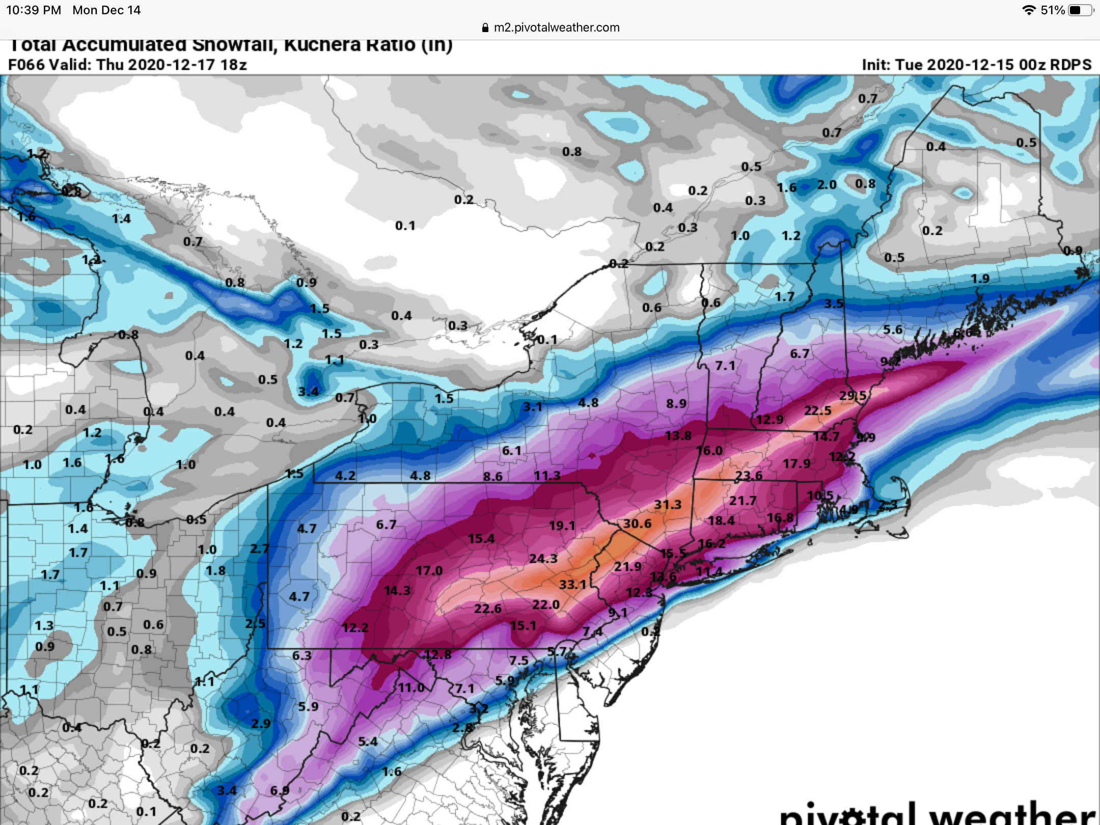
Plus the euro is showing higher winds that’s forecasted in our area
-
Basically holding serve in our area 14-18” wind gusts to around 30.
-
What will be impressive IMHO will be the blowing and drifting especially along some open areas along I-84. Going to make driving basically impossible. I’m thinking they shut it down for the overnight period. Wdrag has mentioned that drifting up to 4’ is possible in some areas.
-
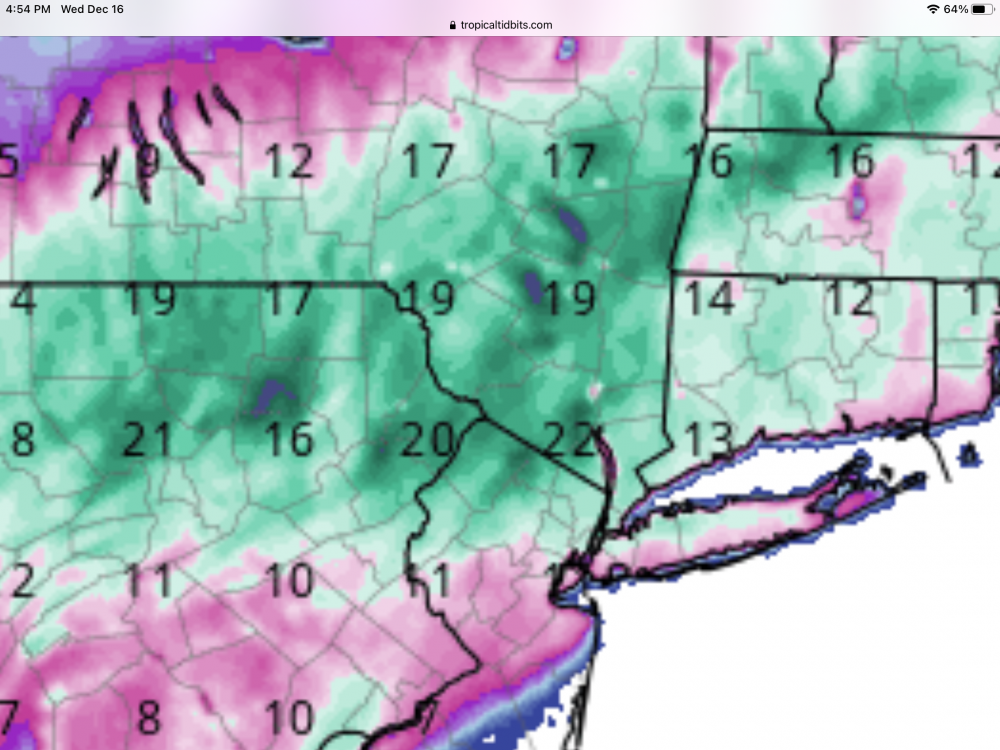
Lot’s of pretty colors. Of course it’s just porn.

-
Upton’s

-
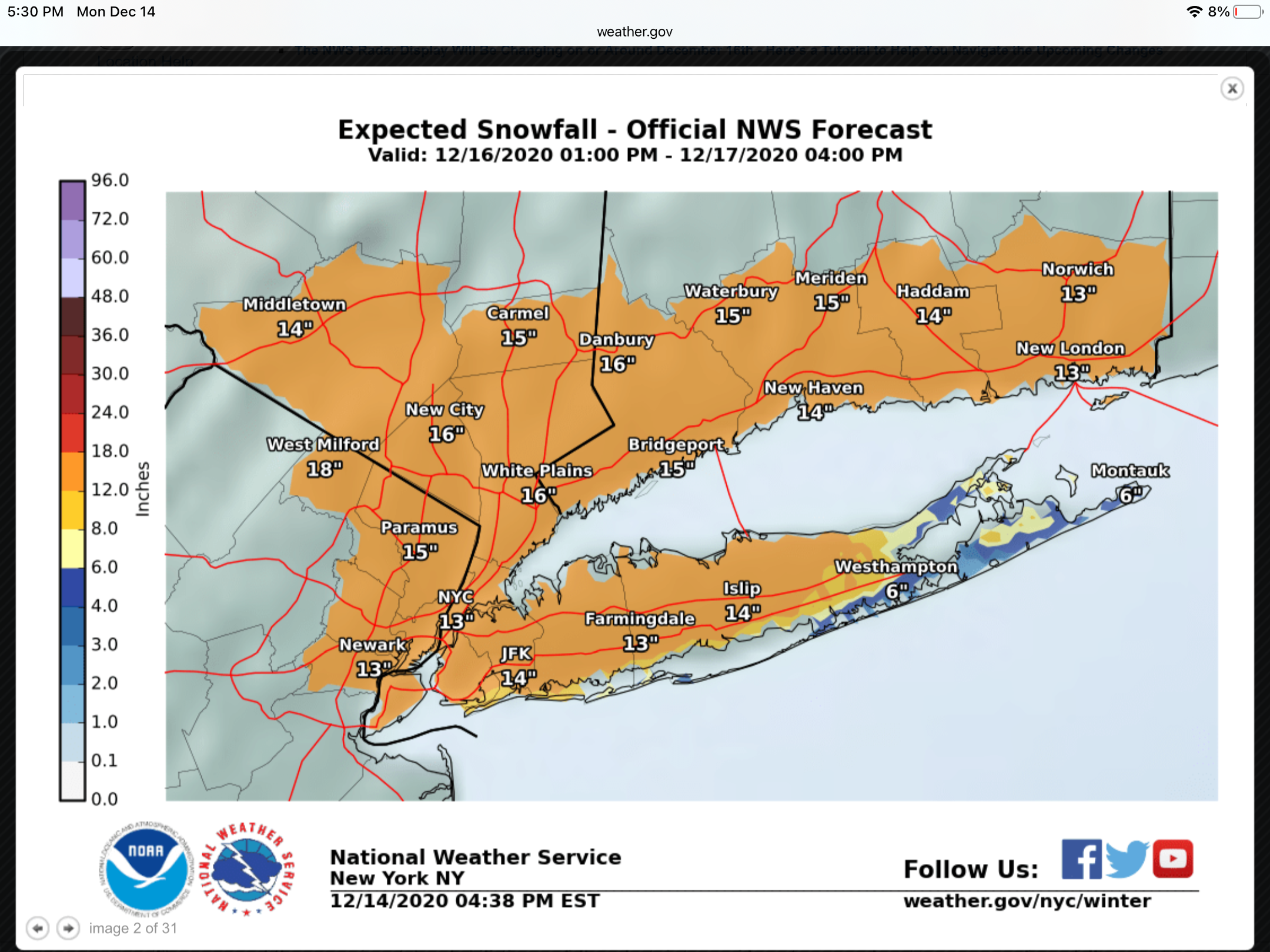
URGENT - WINTER WEATHER MESSAGE National Weather Service New York NY 400 PM EST Mon Dec 14 2020 CTZ005>012-NJZ002-004-006-103>108-NYZ067>071-151000- /O.NEW.KOKX.WS.A.0001.201216T1900Z-201217T1800Z/ Northern Fairfield-Northern New Haven-Northern Middlesex- Northern New London-Southern Fairfield-Southern New Haven- Southern Middlesex-Southern New London-Western Passaic- Eastern Passaic-Hudson-Western Bergen-Eastern Bergen- Western Essex-Eastern Essex-Western Union-Eastern Union-Orange- Putnam-Rockland-Northern Westchester-Southern Westchester- 400 PM EST Mon Dec 14 2020 ...WINTER STORM WATCH IN EFFECT FROM WEDNESDAY AFTERNOON THROUGH THURSDAY AFTERNOON... * WHAT...Heavy snow possible. Total snow accumulations of 12 to 17 inches possible. Winds could gust as high as 45 mph, especially along the coast. * WHERE...Portions of northeast New Jersey, southern Connecticut and southeast New York. * WHEN...From Wednesday afternoon through Thursday afternoon. * IMPACTS...Travel could be very difficult to impossible. Hazardous conditions could impact the Wednesday evening and Thursday morning commute. PRECAUTIONARY/PREPAREDNESS ACTIONS... Monitor the latest forecasts for updates on this situation.
-
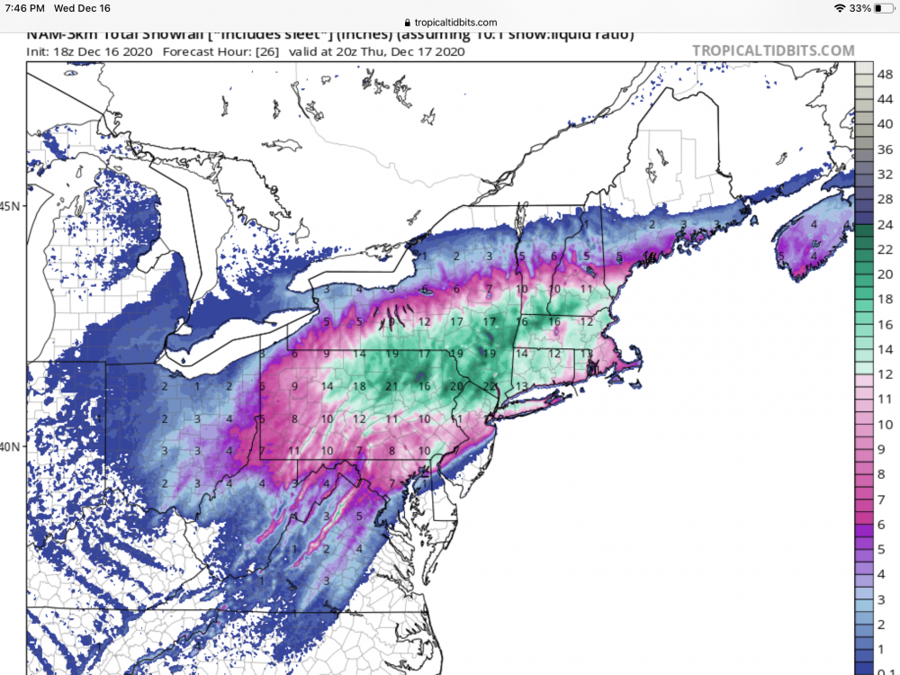
That’s crazy with that lollipop of 30” just south of KALB.