hudsonvalley21
-
Posts
4,276 -
Joined
-
Last visited
Content Type
Profiles
Blogs
Forums
American Weather
Media Demo
Store
Gallery
Everything posted by hudsonvalley21
-
Same here with the power on and off. Just outside picking up some branches. Good s/w wind now with an occasional gust to 35-40.
-
Wow what a cutoff, 1.07 here
-
Got me beat . 2 here.
-
URGENT - IMMEDIATE BROADCAST REQUESTED Tornado Watch Number 410 NWS Storm Prediction Center Norman OK 310 PM EDT Sun Aug 2 2020 The NWS Storm Prediction Center has issued a * Tornado Watch for portions of Central and western Connecticut Western Massachusetts Extreme northern New Jersey Eastern New York Extreme northeast Pennsylvania Western Vermont * Effective this Sunday afternoon and evening from 310 PM until 1000 PM EDT. * Primary threats include... A few tornadoes possible Scattered damaging wind gusts to 70 mph possible Isolated large hail events to 1.5 inches in diameter possible SUMMARY...Scattered severe thunderstorms are expected across the watch area the remainder of this afternoon and early evening. A few tornadoes will be possible along with damaging straight-line winds and isolated large hail. The tornado watch area is approximately along and 70 statute miles east and west of a line from 35 miles north northwest of Saranac Lake NY to 25 miles south of Poughkeepsie NY. For a complete depiction of the watch see the associated watch outline update (WOUS64 KWNS WOU0).
-
Super dry here too. Hopefully we will get some of the tropical action to give things a drink. We have a chance before Isaias on Sunday but might be on the severe side. A section of Upton AFD, LONG TERM /SUNDAY THROUGH FRIDAY/... Although the focus of the long term remains Isaias, there is the potential for a round of significant severe weather on Sunday. A warm front is progged to be lifting thru the area on Sun. The 12Z NAM builds SBCAPE to over 3000 J/kg. Sufficient shear puts the BRN firmly in the supercell range. In addition, A high EHI embedded in this regime will add a tor threat. It is still too far out to have high confidence in the details and timing, but the data suggests the ingredients are potentially there for a svr wx outbreak. Future forecasts and SPC outlooks will refine this threat over the weekend. Pops were limited to 50 percent based on the uncertainty, although the NBM suggests categorical across the interior.
-
74 was the low here. It was 81 at 11pm last night. Thank god for air conditioning.
-
Definitely felt the heat today. 97 is impressive.
-
Got you beat again, 93 here.
-
Got you both beat. .05
-
Looks like we will tonight. Nice batch over by Port Jervis at this time. Special Weather Statement National Weather Service Binghamton NY 948 PM EDT Sun Jul 12 2020 NYZ062-PAZ048-130245- Sullivan NY-Pike PA- 948 PM EDT Sun Jul 12 2020 ...LOCALLY HEAVY RAINFALL WILL AFFECT SULLIVAN AND PIKE COUNTIES... At 948 PM EDT, Doppler radar indicated a large area of showers covering South Central Sullivan County, as well as most of Pike County. The showers should continue spreading northeast into the remainder of Sullivan County late this evening.
-
That sucks . It came thru here with stronger winds than what I had yesterday too. 0.91 yesterday and .42 today so far.
-
.73”
-
Maybe tomorrow will be better. SPC AC 101731 Day 2 Convective Outlook NWS Storm Prediction Center Norman OK 1231 PM CDT Fri Jul 10 2020 While T.C. Fay is forecast by the National Hurricane Center to move quickly into Canada Saturday morning, rich low-level moisture and modestly enhanced low/mid-level flow will likely remain in its wake from the northern Mid Atlantic into portions of New England, in advance of the shortwave trough moving eastward from the OH Valley. Renewed thunderstorm development is expected by late morning/early afternoon, with the strongest storms capable of localized wind damage. And a section of Upton’s AFD SHORT TERM /6 AM SATURDAY MORNING THROUGH SATURDAY NIGHT/... Despite the exit of Fay, a moist airmass will remain in place and allow for destabilization during the day. At the same time, an upr trof will approach from the w. As cin erodes, tstm initiation over the cwa is likely. The 12Z NAM indicated around 3000 CAPE in the aftn and eve. The main limiting factor is whether any earlier convection works over the atmosphere sufficiently. The primary svr threats will be damaging winds and hail. Severe wording and damaging winds have been included in the fcst for wrn areas to highlight the threat. Any activity is modeled to diminish in the overnight period as dry air sweeps in at the mid lvls. The NBM was used for temps. Heat indices will be close to 95 for much of the area. An advy may be needed based on the 2 day criteria Sat and Sun.
-
wdrag posted in the other thread that he had 1.58 over in Wantage. So that’s over towards his direction.
-
Well needed. The grass is coming back somewhat.
-
It was around an hour and a half to hit that. So far today I’m at 0.60 and it’s taken 5 hours It feels like drizzle compared to the other day.
-
Doubt it will match my 3.82 from the other day. 0.16 so far
-
Not good at all. Hopefully we can dodge the bullet Friday night into Saturday. Currently, light rain with rumbles of thunder. 3.78 in the bucket.
-
Wow can you post an image or link? My total is 3.68 just winding down for now.
-
Had a max rain rate of 7.29 per hour. So far 2.56 in the bucket from this first cell edit. 3.53 in the bucket.
-
0.37 here for the day.
-
Yup it was a quick hit not at severe criteria here. Had 0.17 in the early am event and 0.52 in this recent one. 0.69 for the day.
-
Till now
-
I’ll second that.
-
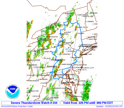
Hazardous Weather Outlook National Weather Service New York NY 227 PM EDT Fri May 29 2020 NYZ067-301830- Orange- 227 PM EDT Fri May 29 2020 ...SEVERE THUNDERSTORM WATCH 234 IN EFFECT UNTIL 9 PM EDT THIS EVENING... This Hazardous Weather Outlook is for southeast New York. .DAY ONE...This afternoon and tonight.