hudsonvalley21
-
Posts
4,276 -
Joined
-
Last visited
Content Type
Profiles
Blogs
Forums
American Weather
Media Demo
Store
Gallery
Everything posted by hudsonvalley21
-
0.42 in the bucket will do it for today here.
-
I don’t get it.
-
Similar here with the two rounds. First found had a few gusts to 35-40. Total in the bucket so far 0.74. Looks like another round in an hour or so.
-
Classic
-
Missed here too. Fell apart.
-
Special Weather Statement National Weather Service New York NY 645 PM EDT Sat May 9 2020 CTZ005>012-NYZ067-068-070-092345- Southern Middlesex-Northern Fairfield-Southern New London-Southern Fairfield-Northern New London-Northern New Haven-Northern Middlesex-Southern New Haven-Putnam-Northern Westchester-Orange- 645 PM EDT Sat May 9 2020 ...FAST MOVING BANDS OF SNOW SQUALLS WILL AFFECT PORTIONS OF THE LOWER HUDSON VALLEY AND SOUTHERN CONNECTICUT... At 640 PM EDT, National Weather Service Doppler radar showed bands of snow squalls extending from Bristol to New Fairfield to near Kerhonkson to Maplewood to Gibson. Movement was southeast at 50 mph. Winds up to 45 mph and visibilities 1/4 to 1/2 mile are likely with the heavier squalls. These squalls will be near... Cheshire and Bethel around 645 PM EDT. Newtown around 650 PM EDT. Meriden and Middletown around 655 PM EDT. Bridgeport and Middletown around 705 PM EDT. Shelton and East Hampton around 710 PM EDT. New Haven and Milford around 715 PM EDT. Chester around 720 PM EDT. Brewster and Carmel around 730 PM EDT. Cold Spring and West Point around 735 PM EDT.
-
Nice snow squall to our northwest. Let’s see if it holds together. Special Weather Statement National Weather Service Binghamton NY 344 PM EDT Sat May 9 2020 NYZ009-015>018-022>025-036-037-044>046-055>057-062-PAZ038>040- 100000- Northern Oneida-Yates-Seneca-Southern Cayuga-Onondaga-Steuben- Schuyler-Chemung-Tompkins-Madison-Southern Oneida-Cortland- Chenango-Otsego-Tioga-Broome-Delaware-Sullivan-Bradford- Susquehanna-Northern Wayne- 344 PM EDT Sat May 9 2020 ...HEAVY SNOW SHOWERS EXPECTED THROUGH THIS EVENING... Scattered heavy snow showers will continue through this evening. Localized accumulations of 1 to 3 inches will be possible across higher terrain, with a coating of snow possible at lower elevations. In addition, heavy snow squalls will cause rapidly changing travel conditions with visibility less than a quarter mile and slippery spots on roads.
-
BxEngine will be parked around the corner from you with the heat on high and the windows open. This model has that factored in
-
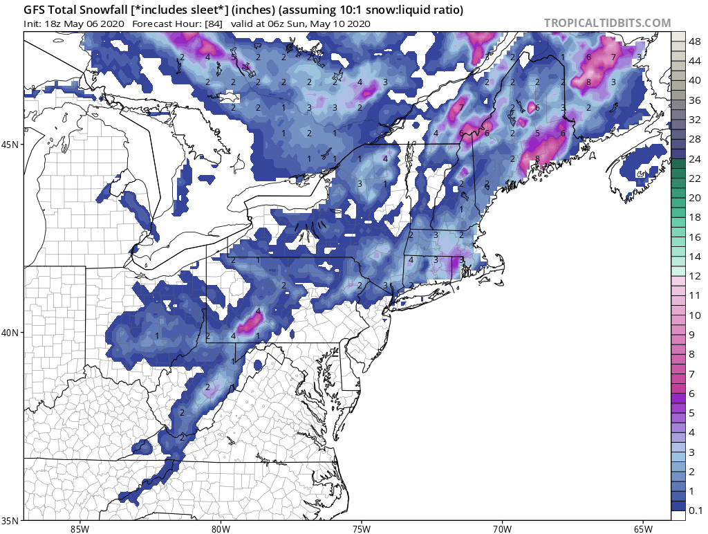
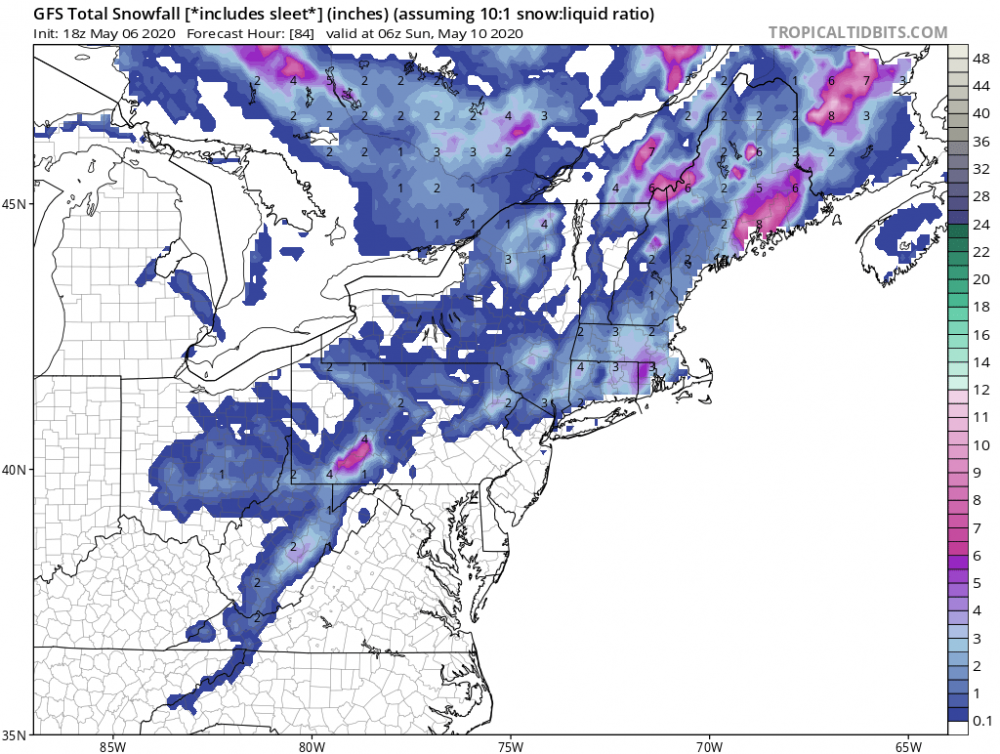
Might as well put this map too. Let’s go all in.
-
A very noticeable change from 24 hours ago, currently 49 degrees and a wind steady around 20 mph. This time yesterday 73 degrees.
-
1.22 in the Davis for the event.
-
Same here, the furry little rodents hit my tomatoes too. Then the friggin birds hit the blue and raspberries.
-
Agree, I will be definitely concerning to go to beaches, sporting events, concerts etc. when things finally open up. What will be the new norm. We’ll see.
-
Not too bad, small place that can fit about 30-40 people. Weeknights are better no rif-raf
-
A bunch of the mom and pop restaurants and local bars are closed. Hope it won’t be long so they can reopen before they hit the point of no return. A buddy of mine owns a small tavern and is closed, he is back driving trucks. Down to 36 and some white rain mixing in.
-
All liquid here 37 currently.
-
That’s if they don’t beat you to the rabbits. Plenty of snowshoes here, Chinese takeout place closed the last couple of weeks due to the virus.

-
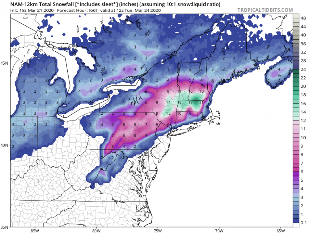
That should be enough to jinx it. I was going to put my snowblower away and open up the pool here is today’s 18z silly NAM
-
Something to watch instead of sports re-runs. We’ll see, stay healthy!
-
Well at least were in the same state URGENT - WINTER WEATHER MESSAGE National Weather Service Buffalo NY 1258 PM EST Wed Feb 26 2020 NYZ006>008-270200- /O.UPG.KBUF.LE.W.0004.200227T1200Z-200229T2300Z/ /O.NEW.KBUF.BZ.W.0001.200227T1200Z-200228T2100Z/ Oswego-Jefferson-Lewis- Including the cities of Oswego, Watertown, and Lowville 1258 PM EST Wed Feb 26 2020 ...BLIZZARD WARNING IN EFFECT FROM 7 AM THURSDAY TO 4 PM EST FRIDAY... * WHAT...Blizzard conditions expected. Total snow accumulations of 3 to 4 feet across the Tug Hill Plateau, and 1 to 2 feet for surrounding lower elevations. Winds gusting as high as 50 to 60 mph will result in severe blowing and drifting snow. * WHERE...The Eastern Lake Ontario Region.
-
Our area is in the jackpot zone for tomorrow.

-
Currently 41/27 here. It will be a nice thump of rain. Upton is optimistic tho. Area Forecast Discussion National Weather Service New York NY 727 PM EST Wed Feb 12 2020 NEAR TERM /THROUGH THURSDAY/... Updated the forecast to delay the timing of PCPN onset. Still some dry air to overcome before it reaches the ground. Also added the mention of a chance of sleet mixing in wherever PCPN begins as rain based on thermal profiles aloft, anticipating a cooling of the column as it saturates. A warm front will approach from the southwest tonight. Isentropic lift along and ahead of the boundary will allow clouds to increase, lower, and thicken. Weak low pressure over Louisiana as of 18Z will ride along this boundary and track toward the area. Light precipitation is expected after 00Z, with chances for precipitation increasing from west to east overnight. The best chances for precipitation look to be between 1 am and 7 am Thursday, this is when lift would be the greatest across the area, with the warm front just to our south and the low to the southwest somewhere over or near Pennsylvania. Therefore, maturate to perhaps briefly heavy precipitation is possible during this time frame. As for precipitation type, plain rain is expected across Long Island, New York City, and much of northeast New Jersey and coastal southern Connecticut. Precipitation may start off as all snow across portions of the interior, such as northern portions of the Lower Hudson Valley, and inland southwest Connecticut. The all snow line may head south a few miles due to dry air in the lower levels leading to column cooling. A wintry mix, mainly of rain and snow, can be expected between these locations. Isolated areas may see some sleet mix in and freezing rain, but again, this will be patchy in nature, and an SPS may be issued later tonight to cover this possibility for inland areas. Strong southwest winds aloft will bring in warmer air rather quickly, with almost the entire forecast area changing over to plain rain a few hours after midnight tonight, with any patchy areas of freezing rain or wintry mix that remain in the far interior or higher elevations changing to plain rain by daybreak Thursday. As for snowfall totals, northern Orange county may see between 1 and 2 inches, while isolated areas such as the higher elevations may see these amounts as well. Elsewhere, under an inch is expected before the changeover.
-
Beautiful pics. I’m jealous. You missed the action here today, got a dusting in snow showers Enjoy up there
-
Enjoy the warmth and have a safe trip
-
Don’t let a little rain stop you.