hudsonvalley21
-
Posts
4,276 -
Joined
-
Last visited
Content Type
Profiles
Blogs
Forums
American Weather
Media Demo
Store
Gallery
Everything posted by hudsonvalley21
-
3.1 will do it here. Have to say the models had a good call on this one for a few days.
-
2.3” OTG 24/22 moderate snow
-
Yup just after making the last post it started up again and the temperature also dropped 1 degree. Another quick 1/3” in a half an hour.
-
Yup the ground temperature is cold. I have the same about 2/3” of an inch. I used the blower instead of a shovel and it came clean off the pavers and deck surfaces. It’s amazing how the the dewpt jumped from 7 to 19 in two hours. Currently 19/19
-
Nothing here a little east of them as of now.
-
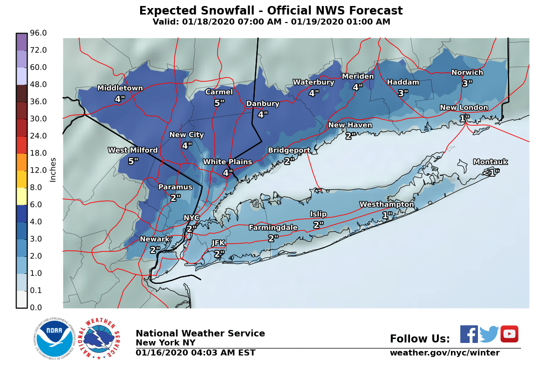
Upton’s snow map
-
.16 in the bucket here. Good day to watch the leaves blow around, tomorrow clean them up when the winds subside. Currently 64/48
-
No snow here yesterday also. Do have a few snow showers today too. Happy new year’s all
-
Maybe the 1st lake snow event. SST's are around 60.
-
The Hudson Valley Thread
hudsonvalley21 replied to IrishRob17's topic in Upstate New York/Pennsylvania
There has been some talk in the NYC thread saying that this could still trend a bit more west. We'll see -
The Hudson Valley Thread
hudsonvalley21 replied to IrishRob17's topic in Upstate New York/Pennsylvania
I think it will be for you. Stay warm. -
The Hudson Valley Thread
hudsonvalley21 replied to IrishRob17's topic in Upstate New York/Pennsylvania
Temp. at 16.1 as of 6pm. Forcast low of -10 for tonite on the east side of the county,-15 on the west side. NATIONAL WEATHER SERVICE NEW YORK NY 414 PM EST SUN JAN 23 2011 ...BITTER COLD... CTZ005>008-NJZ002-103-NYZ067>070-241015- /O.NEW.KOKX.WC.Y.0001.110124T0000Z-110124T1400Z/ NORTHERN FAIRFIELD-NORTHERN NEW HAVEN-NORTHERN MIDDLESEX- NORTHERN NEW LONDON-WESTERN PASSAIC-WESTERN BERGEN-ORANGE-PUTNAM- ROCKLAND-NORTHERN WESTCHESTER- 414 PM EST SUN JAN 23 2011 ...WIND CHILL ADVISORY IN EFFECT FROM 7 PM THIS EVENING TO 9 AM EST MONDAY... THE NATIONAL WEATHER SERVICE IN UPTON HAS ISSUED A WIND CHILL ADVISORY...WHICH IS IN EFFECT FROM 7 PM THIS EVENING TO 9 AM EST MONDAY. * LOCATIONS...INTERIOR CONNECTICUT...INTERIOR LOWER HUDSON VALLEY...AND EXTREME NORTHWESTERN NEW JERSEY. * HAZARDS...BITTERLY COLD WIND CHILLS. * WIND CHILL VALUES...15 TO 20 DEGREES BELOW ZERO. ISOLATED LOCATIONS FALLING TO AROUND 25 BELOW. * WINDS...AROUND 5 MPH. * TEMPERATURES...5 TO 10 DEGREES BELOW ZERO. ISOLATED LOCATIONS FALLING TO AROUND 15 BELOW. * TIMING...TONIGHT INTO EARLY MONDAY MORNING. * IMPACTS...THE FRIGID CONDITIONS WILL BE DANGEROUS TO THOSE VENTURING OUTSIDE. -
The Hudson Valley Thread
hudsonvalley21 replied to IrishRob17's topic in Upstate New York/Pennsylvania
Time to break out the suntan lotion and shorts. -
The Hudson Valley Thread
hudsonvalley21 replied to IrishRob17's topic in Upstate New York/Pennsylvania
Temps. are busting on the low side. REGIONAL WEATHER ROUNDUP NATIONAL WEATHER SERVICE NEW YORK NY 1100 PM EST SAT JAN 22 2011 HUDSON VALLEY CITY SKY/WX TMP DP RH WIND PRES REMARKS NEWBURGH CLEAR 1 -2 85 VRB3 29.86S MONTGOMERY CLEAR -3 -7 82 CALM 29.84F POUGHKEEPSIE CLEAR 0 -3 87 CALM 29.87F ALBANY CLOUDY 6 3 87 CALM 29.88F -
The Hudson Valley Thread
hudsonvalley21 replied to IrishRob17's topic in Upstate New York/Pennsylvania
I put down a base coat of Calcium Chloride last night. And shoveld around 2pm. It came off easy, there was about an inch of top crusted slush. I put down the Calcium Chloride again and have black driveway. And the hits keep on comming. AREA FORECAST DISCUSSION NATIONAL WEATHER SERVICE NEW YORK NY 624 PM EST TUE JAN 18 2011 .SHORT TERM /6 AM WEDNESDAY MORNING THROUGH FRIDAY/... WITH SURFACE TROUGH FROM COASTAL LOW EXTENDED ACROSS THE REGION AND SHORT WAVE MOVING THROUGH WEDNESDAY WILL KEEP POPS WEDNESDAY MORNING AND END IN THE AFTERNOON. SOME UNCERTAINTY WITH THE HOW MUCH QPF BUT GENERALLY LIGHT. WARMING DURING THE DAY WITH ANY FREEZING RAIN OF FREEZING DRIZZLE TRANSITIONING TO LIGHT RAIN OR DRIZZLE. DEPENDING HOW QUICKLY THE WARMER AIR MOVES IN WILL AFFECT THE TRANSITION. RIDGE BUILDS BRIEFLY WEDNESDAY NIGHT INTO THURSDAY. THEN TROUGH MOVING OUT OF THE PLAINS THURSDAY WILL DEVELOP A LOW OVER THE MID ATLANTIC STATES THURSDAY NIGHT WITH A COASTAL LOW DEVELOPING LATER THURSDAY NIGHT AND QUICKLY PASSING THE AREA FRIDAY. STILL SOME MODEL UNCERTAINTY WITH THE TRACK OF THE LOW...WITH THE GFS AND ECMWF FARTHER EAST THAN THE NAM. WITH COLDER AIR BACK IN PLACE BY THURSDAY NIGHT PRECIPITATION WILL BE IN THE FORM OF SNOW. THERE IS A POT ENTAIL FOR AN ACCUMULATING SNOW...AND IF THE STORM TRACKS FARTHER TO THE WEST THERE IS A CHANCE FOR A MORE SIGNIFICANT SNOWFALL ACROSS THE REGION. FOR TEMPERATURES THROUGH THE PERIOD LEANED TOWARD THE COLDER MAV/GFS GUIDANCE. && .LONG TERM /FRIDAY NIGHT THROUGH TUESDAY/... COASTAL LOW PUSHES WELL TO THE NORTHEAST FRIDAY NIGHT AS A LARGE AREA OF HIGH PRESSURE BUILDS FROM JUST SOUTH OF HUDSON BAY INTO THE OHIO VALLEY. ARCTIC AIR CIRCULATING AROUND THE HIGH DROPS INTO THE REGION...SETTING UP CONDITIONS FOR A COLD WEEKEND. LOWS FRIDAY NIGHT SHOULD BE AROUND 10 DEGREES BELOW NORMAL...RANGING FROM THE SINGLE DIGITS OVER INTERIOR SECTIONS TO THE TEENS NEAR THE COASTS. HIGHS SATURDAY WILL BE 10 TO 15 DEGREES BELOW NORMAL...MOSTLY IN THE UPPER TEENS TO LOW 20S. THE HIGH SHOULD BE DIRECTLY OVER THE AREA SATURDAY NIGHT...WITH GOOD RADIATIONAL COOLING CONDITIONS LEADING TO LOWS NEAR ZERO OVER INTERIOR SECTIONS. DEEP UPPER LEVEL TROUGH MOVES INTO THE EASTERN U.S. SATURDAY NIGHT. BOTH ECMWF AND GFS DEVELOP OFFSHORE LOW PRESSURE EAST OF THE CAROLINA/FLORIDA COAST SATURDAY NIGHT THAT PROPAGATES WELL EAST OF THE REGION. FURTHER NORTH...A WEAK CLIPPER SYSTEM DEVELOPS OVER THE GREAT LAKES. GFS CARRIES THE LOW TO THE NORTH OF THE REGION SUNDAY...WHILE ECMWF DISSIPATES IT BEFORE IT REACHES NEW ENGLAND. SLIGHT CHANCE POPS LATE SUNDAY INTO SUNDAY NIGHT FOR LIGHT SNOW FROM THE POTENTIAL CLIPPER SYSTEM. NEXT DEEP UPPER LEVEL TROUGH MOVES INTO THE MIDWEST MONDAY NIGHT...WITH SEVERAL AREAS OF WEAK SURFACE WAVES DEVELOPING OVER THE EASTERN U.S. A POTENTIAL OFFSHORE LOW DEVELOPS NEAR THE SOUTHEAST COAST TUESDAY AND MOVES UP THE COAST INTO WEDNESDAY. SLIGHT CHANCE POPS OVER THE REGION MONDAY THROUGH WEDNESDAY FOR THESE SYSTEMS. BELOW NORMAL...AND BELOW FREEZING...TEMPS WILL CONTINUE THROUGH THE PERIOD...SO ANY PRECIP WOULD LIKELY FALL AS SNOW. && -
The Hudson Valley Thread
hudsonvalley21 replied to IrishRob17's topic in Upstate New York/Pennsylvania
Good to hear that she made it in ok. As for her boss, what an arse hole. -
The Hudson Valley Thread
hudsonvalley21 replied to IrishRob17's topic in Upstate New York/Pennsylvania
Up to 22.0 here -
The Hudson Valley Thread
hudsonvalley21 replied to IrishRob17's topic in Upstate New York/Pennsylvania
Me too. If the NAM comes thru with the QPF. It's going to be a mess. Keep the flashlights charged, might need them tomorrow night. Currently 20.7/1 -
The Hudson Valley Thread
hudsonvalley21 replied to IrishRob17's topic in Upstate New York/Pennsylvania
4pm obs. HUDSON VALLEY CITY SKY/WX TMP DP RH WIND PRES REMARKS NEWBURGH MOCLDY 19 3 49 E8 30.31S WCI 9 MONTGOMERY MOCLDY 20 2 45 N3 30.29F POUGHKEEPSIE CLEAR 22 -7 27 CALM 30.33R ALBANY MOCLDY 13 -6 42 CALM 30.35R This will allow for some evap.cooling later on. ...WINTER STORM WARNING IN EFFECT FROM 1 AM TO 6 PM EST TUESDAY... THE NATIONAL WEATHER SERVICE IN UPTON HAS ISSUED A WINTER STORM WARNING FOR SNOW AND FREEZING RAIN...WHICH IS IN EFFECT FROM 1 AM TO 6 PM EST TUESDAY. THE WINTER STORM WATCH IS NO LONGER IN EFFECT. * LOCATIONS...INTERIOR PORTIONS OF THE LOWER HUDSON VALLEY... SOUTHWESTERN CONNECTICUT...AND NORTHEAST NEW JERSEY * HAZARDS...SNOW...SLEET...AND FREEZING RAIN * ACCUMULATIONS...2 TO 5 INCHES OF SNOW AND SLEET INTO TUESDAY MORNING...THEN A QUARTER TO UP TO A HALF AN INCH OF ICE ON TOP OF THE SNOW AND SLEET FROM TUESDAY MORNING INTO TUESDAY NIGHT. * TEMPERATURES...TEMPERATURES AT THE ONSET OF PRECIPITATION WILL BE IN THE TEENS TO LOWER 20S...THEN SLOWLY RISE TOWARDS THE FREEZING MARK TUESDAY. ANY AREAS THAT GO ABOVE FREEZING TUESDAY...WILL FALL BELOW FREEZING TUESDAY NIGHT. * TIMING...SNOW SHOULD DEVELOP MAINLY AFTER MIDNIGHT TONIGHT...THEN MIX WITH AND CHANGE TO SLEET AND FREEZING RAIN BY AFTERNOON. SOME LOCATIONS COULD CHANGE TO RAIN FOR A PERIOD OF TIME IN THE AFTERNOON...BEFORE CHANGING BACK TO FREEZING RAIN TUESDAY EVENING. PRECIPITATION SHOULD TAPER OFF BY LATE TUESDAY NIGHT. -
The Hudson Valley Thread
hudsonvalley21 replied to IrishRob17's topic in Upstate New York/Pennsylvania
12z NAM came in wetter than the previous 00z run for KSWF. The 00z had 0.87 the 12z has 1.42. Could have some serious ice issues if the NAM is right. OKX disc. AREA FORECAST DISCUSSION NATIONAL WEATHER SERVICE NEW YORK NY 937 AM EST MON JAN 17 2011 .SHORT TERM /6 PM THIS EVENING THROUGH TUESDAY NIGHT/... MODELS ARE COMING INTO BETTER AGREEMENT ON THE STORM SYSTEM TO IMPACT THE REGION FROM LATE TONIGHT THROUGH TUESDAY NIGHT. ALL NOW AGREE THAT THE DAMMING HIGH WILL LINGER INTO TUESDAY EVENING OVER FAR NW PORTIONS OF THE AREA. THIS DAMMING HIGH WILL SERVE TO HELP KEEP COLD AIR TRAPPED IN PLACE AT THE SURFACE...ESPECIALLY FROM INTERIOR SW CT...WEST TO ORANGE AND WESTERN PASSAIC COUNTIES...WHERE TEMPERATURES MIGHT NOT GET ABOVE FREEZING THROUGH THE EVENT. THE MODELS AGREE THAT THE LOW WILL BE NEAR CAPE HATTERAS AROUND 12Z TUESDAY AND NEAR CAPE COD BY 6Z WEDNESDAY...PASSING IN BETWEEN LONG ISLAND AND THE 40N/70W BENCHMARK...AND DEEPENING AROUND 10 HPA AS IT DOES SO. THE DAMMING HIGH WILL SERVE AS AN OVER RUNNING SURFACE FOR MOISTURE RIDING N ON A S-SE 20-30 KT LOW LEVEL JET AHEAD OF THE SYSTEM MONDAY NIGHT AND TUESDAY. THE RESULT IS SNOW WILL DEVELOP ACROSS THE REGION FROM SW TO NE MONDAY NIGHT...MAINLY AFTER MIDNIGHT. IN ADDITION TO THE UNCERTAINTY ON WHERE AND HOW FAST TEMPERATURES RISE ABOVE FREEZING...THERE IS ALSO UNCERTAINTY ON HOW FAST...AND DEEP THE LOW LEVELS WARM ABOVE FREEZING. THE NAM OFFERS THE LEAST AMOUNT OFF...AND THE SHALLOWEST WARMING...THE GFS IS THE WARMEST...AND HAS THE DEEPEST WARM LAYER...WHILE THE ECMWF IS SOMEWHERE IN BETWEEN. HOW THIS PLAYS OUT WILL DETERMINE...ESPECIALLY ACROSS THE INTERIOR...HOW QUICKLY THE SNOW MIXES/CHANGES TO SLEET AND FREEZING RAIN - AND TO ALL RAIN ACROSS COASTAL AREAS INCLUDING NYC. FOR NOW OPTED FOR A BLEND OF NAM/GFS LOW LEVEL THERMAL FEATURES. WHAT DOES APPEAR FAIRLY CERTAIN...IS THAT THERE WILL BE AN ACCUMULATING SNOW BEFORE THE MIXING BEGINS MONDAY NIGHT...WITH AMOUNTS FROM A DUSTING TO AN INCH ACROSS LONG ISLAND. 1-2 INCHES ACROSS THE NYC METRO AND COASTAL CT...AND 2-4 INCHES ACROSS INTERIOR PORTIONS OF THE LOWER HUDSON VALLEY...NE NJ...AND CT...WHERE JUST SNOW WILL CONTINUE LONGER...INTO TUESDAY MORNING. THE UNCERTAINTY LIES IN HOW MUCH FREEZING RAIN FALLS AFTER THIS...BEFORE A CHANGE OVER TO RAIN FOR ALL BUT MOST LIKELY INTERIOR SW CT...LOWER HUDSON VALLEY AND WESTERN PASSAIC COUNTY DURING THE DAY ON TUESDAY. FOR NOW GOING WITH A GLAZE TO UP TO A TENTH OF AN INCH OF ICE ACROSS THE NYC METRO AND COASTAL AND SE CT. THERE IS THE POTENTIAL FOR UP TO A HALF AN INCH OF ICE...AND MAYBE MORE DEPENDING ON HOW MUCH SNOW ACTUALLY FALLS...AND IF TEMPERATURES GET ABOVE FREEZING...ACROSS INTERIOR PORTIONS OF THE LOWER HUDSON VALLEY...SW CT...AND WESTERN PASSAIC COUNTY. IN THESE AREAS...SOME LOCATIONS MIGHT NOT GET ABOVE FREEZING...AND THOSE THAT DO...LIKELY WILL FALL BELOW FREEZING TUESDAY NIGHT BEFORE THE PRECIPITATION TAPERS OFF. AS A RESULT HAVE ISSUED A WINTER STORM WATCH FOR THESE LOCATIONS FROM 1 AM TUESDAY THROUGH 6 AM WEDNESDAY. WINTER WEATHER ADVISORIES WILL LIKELY BE ISSUED FOR MOST IF NOT ALL OF THE REMAINDER OF THE AREA LATER TODAY...DEPENDING ON CONFIDENCE IN AT LEAST A GLAZE OF ICE IN A GIVEN ZONE. AS FOR TEMPERATURES...BLENDED MAV/MET GUIDANCE AND ADDED A DEGREE (TO FAVOR WARMER GUIDANCE) FOR LOWS TONIGHT. THESE SHOULD BE IN THE EVENING...WITH SLOWLY RISING TEMPERATURES INTO THE OVERNIGHT. FOR TUESDAY...USED NAM 2-METER TEMPERATURES...AS THEY HAVE HISTORICALLY FARED VERY WELL IN THESE IN-SITU DAMMING SITUATIONS. FOR LOWS TUESDAY NIGHT BLENDED MAV/MET GUIDANCE WITH NAM 2-METER TEMPERATURES. && -
The Hudson Valley Thread
hudsonvalley21 replied to IrishRob17's topic in Upstate New York/Pennsylvania
Sorry to hear this. Thank god you did not fall off the lader and had more injuries or worse. I made an attempt at mine today but it's solid ice in the gutters and downspouts. This won't be going anywhere soon. Feel better. -
The Hudson Valley Thread
hudsonvalley21 replied to IrishRob17's topic in Upstate New York/Pennsylvania
Not yet ,still at 9.1. Must be the river temp fighting it off. -
The Hudson Valley Thread
hudsonvalley21 replied to IrishRob17's topic in Upstate New York/Pennsylvania
Heat wave here 9.1. Forcast low is 8, think I'll beat that soon. -
The Hudson Valley Thread
hudsonvalley21 replied to IrishRob17's topic in Upstate New York/Pennsylvania
Coldest of the season so far ,currently at 1.8 -
The Hudson Valley Thread
hudsonvalley21 replied to IrishRob17's topic in Upstate New York/Pennsylvania
Forcast low IMBY is 10. Down to 18.3 so far.