hudsonvalley21
-
Posts
4,265 -
Joined
-
Last visited
Content Type
Profiles
Blogs
Forums
American Weather
Media Demo
Store
Gallery
Everything posted by hudsonvalley21
-
0.64 here in the bucket today. Could add some more overnight after midnight.
-
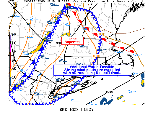
Mesoscale Discussion 1637 NWS Storm Prediction Center Norman OK 0545 PM CDT Sat Aug 29 2020 Areas affected...southeast New York...Connecticut...Massachusetts...New Hampshire Concerning...Severe Thunderstorm Watch 469... Valid 292245Z - 300045Z The severe weather threat for Severe Thunderstorm Watch 469 continues. SUMMARY...A primarily damaging wind threat may spread south and east of the severe thunderstorm watch 469. An additional watch is possible. DISCUSSION...A line of storms continues to increase in coverage and intensity along the cold front, now approaching the ALB area and extending southwestward in segmented fashion into eastern PA. Around 1500 J/kg MLCAPE exists ahead of the front, along with increasing GPS PWAT values up to 2.00" from the Chesapeake to CT. The moist air mass, combined with lift along the front should maintain a threat of storms along the front, with a few severe gusts possible. ..Jewell.. 08/29/2020
-
Yup real close. Dodged a bullet. Others weren’t so lucky. The view would have been awesome from up by the parking lot especially being on the southern side of the cell.
-
PUBLIC INFORMATION STATEMENT NATIONAL WEATHER SERVICE NEW YORK NY 934 PM EDT FRI AUG 28 2020 ...NWS DAMAGE SURVEY FOR 08/27/2020 TORNADO EVENT... ...EF1 TORNADO CONFIRMED IN MONTGOMERY, NY... START LOCATION...ORANGE COUNTY AIRPORT, ORANGE COUNTY, NY END LOCATION...OLD NEALYTOWN ROAD, ORANGE COUNTY, NY DATE...AUGUST 27, 2020 ESTIMATED TIME...6:15 PM TO 6:20 PM MAXIMUM EF-SCALE RATING...EF1 ESTIMATED MAXIMUM WIND SPEED...90 MPH MAXIMUM PATH WIDTH...600 YARDS PATH LENGTH...2.6 MILES BEGINNING LAT/LON...41.525581/-74.26033 INTERMEDIATE LAT/LON...41.518964/-74.248640 ENDING LAT/LON...41.511234/-74.215244 * FATALITIES...0 * INJURIES...0 ...SUMMARY... A NATIONAL WEATHER SERVICE STORM SURVEY TEAM CONFIRMED AN EF1 TORNADO IN MONTGOMERY, ORANGE COUNTY, NY. THE TORNADO LIKELY TOUCHED DOWN ON THE NORTHWEST SIDE OF THE ORANGE COUNTY AIRPORT NEAR THE WALLKILL RIVER. STRAIGHT LINE WINDS ON THE SOUTHERN FLANK OF THE TORNADO LIKELY CAUSED TREE DAMAGE AT THE INTERSECTION OF ROUTE 211 AND CANNING ROAD AS WELL AS MINOR STRUCTURAL DAMAGE NOTED TO TWO BUILDINGS ON THE AIRPORT. A TEMPORARY METEOROLOGICAL STATION, INSTALLED ON THE AIRFIELD TO SUPPORT THIS WEEKEND'S AIRSHOW, MEASURED SUSTAINED WINDS OF 69 MPH WITH A PEAK GUST OF 82 MPH BEFORE THE COMMUNICATIONS WENT OUT. THE TORNADO MOVED EAST FROM NEAR THE RIVER INTO THE VILLAGE OF MONTGOMERY, WHERE DAMAGE WAS EXTENSIVE ALONG WEAVER STREET, AS WELL AS CHANDLER LANE. THE TORNADO THEN CONTINUED EASTWARD ACROSS BEAVER DAM ROAD TO OLD NEALYTOWN ROAD WHERE IT ENDED. THE BULK OF THE DAMAGE CONSISTED OF LARGE SNAPPED AND UPROOTED TREES. THE NWS WOULD LIKE TO THANK EMERGENCY MANAGEMENT, LAW ENFORCEMENT, BROADCAST MEDIA, SPOTTERS WHO SHARED VIDEO AND PHOTOGRAPHIC EVIDENCE, AND REPORTS FROM THE GENERAL PUBLIC THROUGH SOCIAL MEDIA, IN ASSISTING IN THE SURVEY AND FORMULATING THIS PRELIMINARY DAMAGE ASSESSMENT.
-
That was the strongest cell that came thru here today.
-
Great to hear that you got it going. Hopefully it doesn’t give you any more issues
-
Glad to hear no damage to the house. Hopefully the power is back soon. Sounds like a dead cell in the car battery. You could have a liquid dinner never too late for that.
-
0.92 so far. Had a transformer pop before in the area during the first round. Lights flashed for a second and the power automatically rerouted. Lucky me. Timed it right as per driving today. Left Lake George around 10 am before the line ramped up. edit. 1.04 now.
-
Digital are easier to read especially if your upside down.

-

-
Hang in there. They are making good progress now. Hopefully it’s back up tomorrow.
-

-
Agree with the unusual wind direction, rare too see the ESE at 50 then flip around to the SW and gust up to 45-50. This more than likely added to the high tree / utility damage. Most of the times winds that high are out of the west or northwest.
-
I herd the transformers popping over that way this afternoon. The power is out towards that direction. I lucked out, the power is out near the the pharmacy and the post office.
-
Wow that sucks. Hopefully it won’t take that long to get hooked back up and you have no property damage from falling trees.
-
Great to hear. My daughter still is without power in Goshen. Are your folks in New Windsor powered up?
-

-
Maybe they should buy a generator
-
Same here with the power on and off. Just outside picking up some branches. Good s/w wind now with an occasional gust to 35-40.
-
Wow what a cutoff, 1.07 here
-
Got me beat . 2 here.
-
URGENT - IMMEDIATE BROADCAST REQUESTED Tornado Watch Number 410 NWS Storm Prediction Center Norman OK 310 PM EDT Sun Aug 2 2020 The NWS Storm Prediction Center has issued a * Tornado Watch for portions of Central and western Connecticut Western Massachusetts Extreme northern New Jersey Eastern New York Extreme northeast Pennsylvania Western Vermont * Effective this Sunday afternoon and evening from 310 PM until 1000 PM EDT. * Primary threats include... A few tornadoes possible Scattered damaging wind gusts to 70 mph possible Isolated large hail events to 1.5 inches in diameter possible SUMMARY...Scattered severe thunderstorms are expected across the watch area the remainder of this afternoon and early evening. A few tornadoes will be possible along with damaging straight-line winds and isolated large hail. The tornado watch area is approximately along and 70 statute miles east and west of a line from 35 miles north northwest of Saranac Lake NY to 25 miles south of Poughkeepsie NY. For a complete depiction of the watch see the associated watch outline update (WOUS64 KWNS WOU0).
-
Super dry here too. Hopefully we will get some of the tropical action to give things a drink. We have a chance before Isaias on Sunday but might be on the severe side. A section of Upton AFD, LONG TERM /SUNDAY THROUGH FRIDAY/... Although the focus of the long term remains Isaias, there is the potential for a round of significant severe weather on Sunday. A warm front is progged to be lifting thru the area on Sun. The 12Z NAM builds SBCAPE to over 3000 J/kg. Sufficient shear puts the BRN firmly in the supercell range. In addition, A high EHI embedded in this regime will add a tor threat. It is still too far out to have high confidence in the details and timing, but the data suggests the ingredients are potentially there for a svr wx outbreak. Future forecasts and SPC outlooks will refine this threat over the weekend. Pops were limited to 50 percent based on the uncertainty, although the NBM suggests categorical across the interior.
-
74 was the low here. It was 81 at 11pm last night. Thank god for air conditioning.
-
Definitely felt the heat today. 97 is impressive.