hudsonvalley21
-
Posts
4,276 -
Joined
-
Last visited
Content Type
Profiles
Blogs
Forums
American Weather
Media Demo
Store
Gallery
Everything posted by hudsonvalley21
-
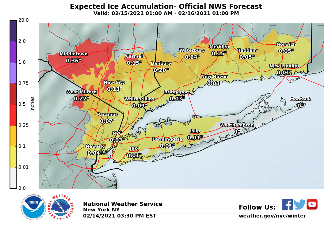
If the temps were in the lower to mid 20’s and held steady it would make a great factor in ice accumulation. Point and click forecast for me is a high of 28 tomorrow and temps rising slightly Monday night into Tuesday.
-
They do have a history of being conservative at times. In their defense, our forecast area has such a variable and challenging forecast by location. I wouldn’t want to be in their shoes.
-
National Weather Service New York NY 332 PM EST Sun Feb 14 2021 NJZ002-NYZ067-150445- /O.NEW.KOKX.IS.W.0001.210215T2300Z-210216T1500Z/ /O.NEW.KOKX.WW.Y.0007.210215T1200Z-210215T2300Z/ Western Passaic-Orange- 332 PM EST Sun Feb 14 2021 ...WINTER WEATHER ADVISORY IN EFFECT FROM 7 AM TO 6 PM EST MONDAY... ...ICE STORM WARNING IN EFFECT FROM 6 PM MONDAY TO 10 AM EST TUESDAY... * WHAT...For the Ice Storm Warning, significant icing expected. Total ice accumulations of up to a half an inch. For the Winter Weather Advisory, mixed precipitation expected. Total snow accumulations of up to one inch and ice accumulations of a light glaze. * WHERE...In New Jersey, Western Passaic County. In New York, Orange County. * WHEN...For the Ice Storm Warning, from 6 PM Monday to 10 AM EST Tuesday. For the Winter Weather Advisory, from 7 AM to 6 PM EST Monday. * IMPACTS...Power outages and tree damage are likely due to the ice. Travel could be nearly impossible. The hazardous conditions could impact the morning and evening commutes.

-
Usually in an obs thread mapping is seldom used, its basically now casting. You can compare the short term models such as the HRRR and the NAM.
-
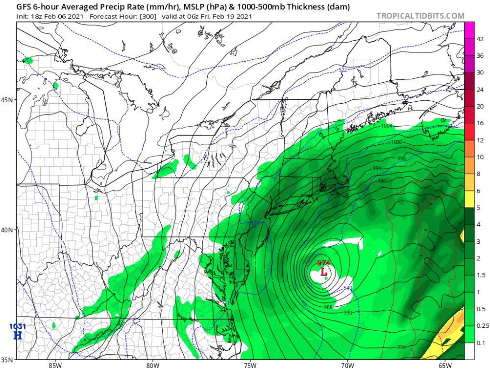
Feb 18-19 long duration manageable snow and ice event
hudsonvalley21 replied to wdrag's topic in New York City Metro
Constantly changing model runs for the last few days. Forecasting is basically going down to now casting, or at least it appears that way. -
Same here with the period of light snow. Was not forecasted. 26/25
-
Wouldn’t mind seeing some rain Tuesday to reduce the ice damming in gutters up this way. Then let’s add to the snowpack on Thursday
-
Is it just the surface temps? Wonder if the mid-levels have also trended cooler?
-
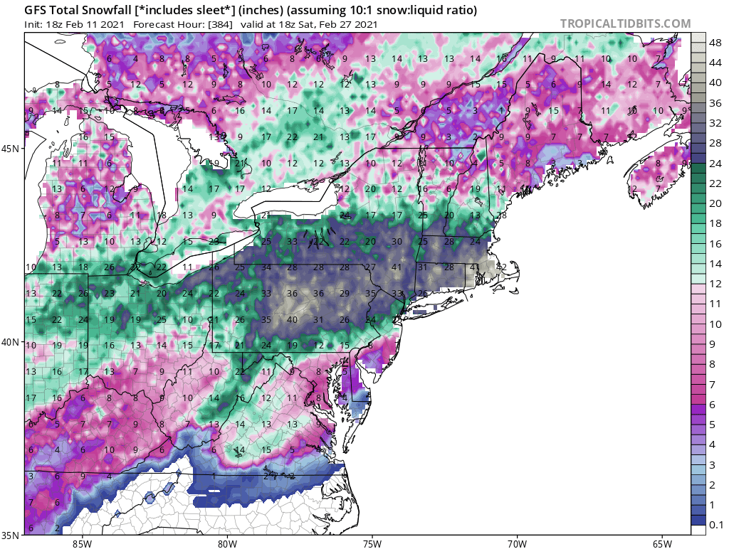
I gave gutter deicers and roof racked about 1 foot back. The deicers had a tough time keeping up. Chopped ice for about 4 hours today. Hope the 18z porn maps don’t come to fruition for the next 2 weeks.
-
Re-measure and join the dark side.
-
3.8” Is the total here.
-
OBs and nowcast TUESDAY 2A-6P Feb 9, 2021
hudsonvalley21 replied to wdrag's topic in New York City Metro
3.8” Is the total here.- 82 replies
-
- 2
-

-

-
- snow
- freezing rain
- (and 1 more)
-
Additional 1-5" snow mostly North of I80 Tuesday Feb 9
hudsonvalley21 replied to wdrag's topic in New York City Metro
OKX just posted for some too. Winter Weather Advisory URGENT - WINTER WEATHER MESSAGE National Weather Service New York NY 328 PM EST Mon Feb 8 2021 CTZ005>008-NJZ002-004-103-NYZ067>070-091000- /O.NEW.KOKX.WW.Y.0004.210209T0900Z-210210T0600Z/ Northern Fairfield-Northern New Haven-Northern Middlesex- Northern New London-Western Passaic-Eastern Passaic- Western Bergen-Orange-Putnam-Rockland-Northern Westchester- 328 PM EST Mon Feb 8 2021 ...WINTER WEATHER ADVISORY IN EFFECT FROM 4 AM TUESDAY TO 1 AM EST WEDNESDAY... * WHAT...Snow expected. Total snow accumulations of 2 to 4 inches. * WHERE...Portions of northeast New Jersey, southern Connecticut and southeast New York. * WHEN...From 4 AM Tuesday to 1 AM EST Wednesday -
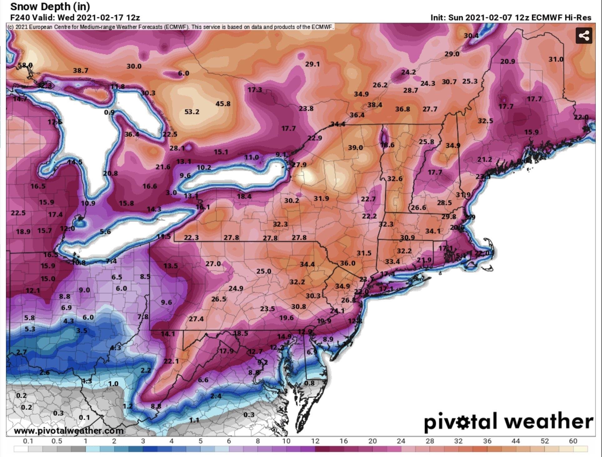
Porn for weather weenies

-
Obs and nowcast Super Bowl Sunday 4A-6P Feb 7, 2021
hudsonvalley21 replied to wdrag's topic in New York City Metro
Sorry, we’re not in the Toronto forum. We are in the special snowhole forum. -
Add another 1.7” to you and take it from what is owed to you from @Juliancolton
-
I’m going to split the uprights 1.45” between you and @snywx
-
Obs and nowcast Super Bowl Sunday 4A-6P Feb 7, 2021
hudsonvalley21 replied to wdrag's topic in New York City Metro
He probably used the uncleared board from the last event -
Obs and nowcast Super Bowl Sunday 4A-6P Feb 7, 2021
hudsonvalley21 replied to wdrag's topic in New York City Metro
Sounds like you have used the NWS approved measurement guidelines. -
0.75” OTG. Better than nothing I guess.
-
2-7-21 Sunday 8-12 hour nor'easter snowstorm roughly 5A-5P
hudsonvalley21 replied to wdrag's topic in New York City Metro
30/13 here -
Additional 1-5" snow mostly North of I80 Tuesday Feb 9
hudsonvalley21 replied to wdrag's topic in New York City Metro
Today’s 18z GFS 24 hour snowfall map for the Tuesday event.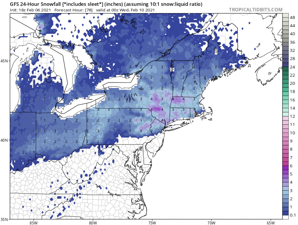
-
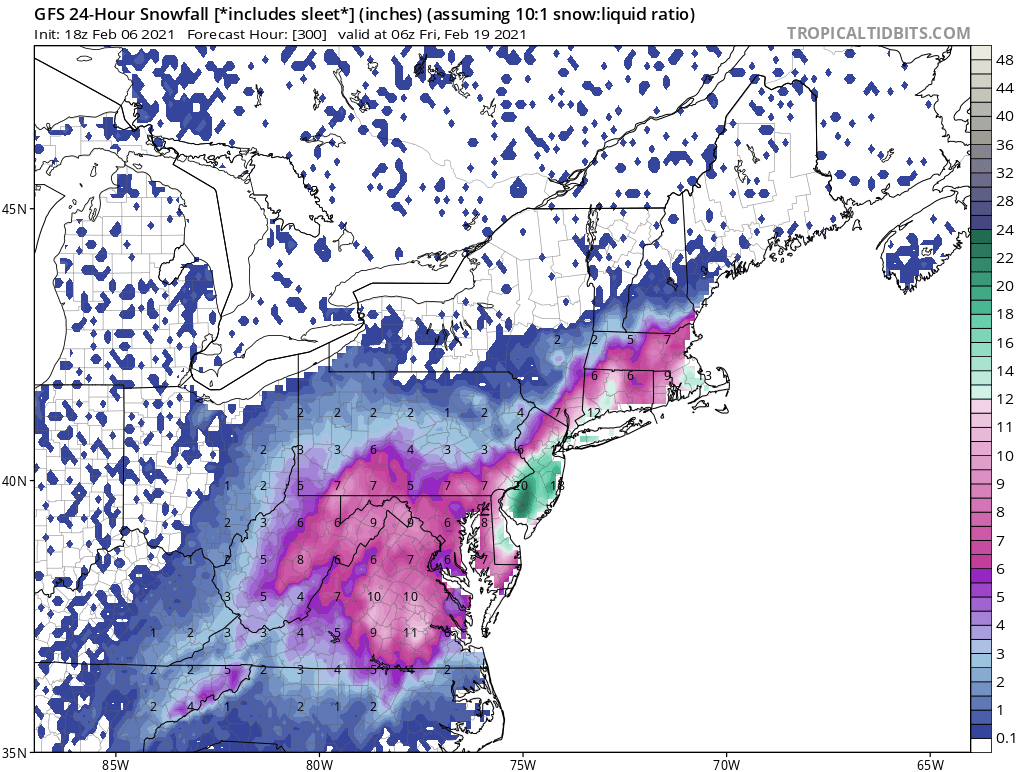
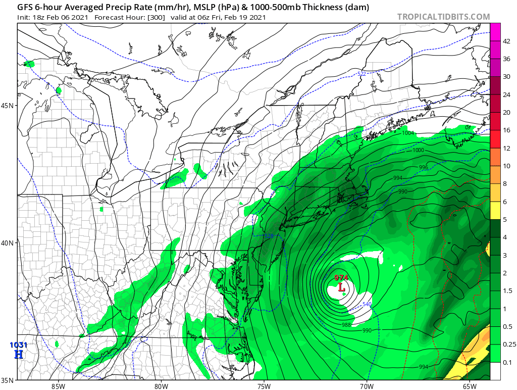
It’s showing a nice event on the 18-19th. Here is the 24 hour snowfall and surface maps for that timeframe.