

hudsonvalley21
-
Posts
4,265 -
Joined
-
Last visited
Content Type
Profiles
Blogs
Forums
American Weather
Media Demo
Store
Gallery
Everything posted by hudsonvalley21
-
I think it’s an a/c night.
-
90 for the high here today. Point and click forecast has 95 for the high tomorrow with a heat index of 104.
-
90 for the high here today. Point and click forecast has 95 for the high tomorrow with a heat index of 104.
-
0.17 here with the line. Nothing severe.
-
We’ll see

-
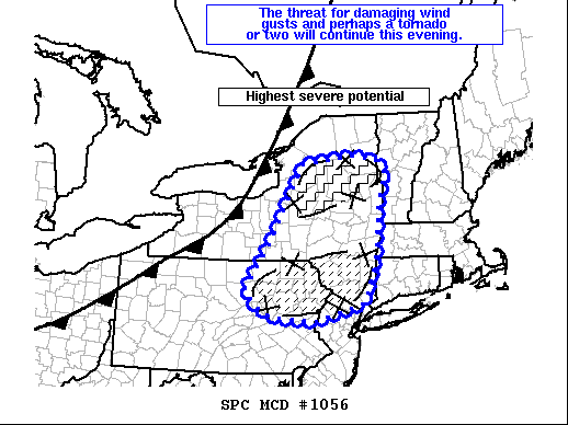
Mesoscale Discussion 1056 NWS Storm Prediction Center Norman OK 0550 PM CDT Mon Jun 21 2021 Areas affected...central and eastern New York into northeast Pennsylvania and far northern New Jersey Concerning...Severe Thunderstorm Watch 300...303... Valid 212250Z - 212345Z The severe weather threat for Severe Thunderstorm Watch 300, 303 continues. SUMMARY...A line of severe thunderstorms with a history of severe gusts and wind damage will likely continue to pose a risk for damaging gusts and perhaps a tornado or two this evening. Additional storm development/consolidation across southern New York and northeast Pennsylvania will pose a risk for damaging winds. DISCUSSION...Ahead of the cold front moving across western New York, a line of thunderstorms near Syracuse has produced a measured severe gust and numerous reports of wind damage over the last hour. Radar data shows a well developed comma head/bowing segment developing east of the KTYX radar. Damaging winds will be likely with this cluster of thunderstorms as they track to the east northeast over the next couple of hours. Regional VWP data also suggests some mesovortex tornado threat may evolve with 0-1km SRH around 100 ms/s2 and 0-3km line normal shear around 30 kts. Some weakening of this portions of the line may occur closer to the border with Vermont as downstream convection has resulted in some airmass modification. Until then, a corridor of greater severe potential will likely evolve. To the south across portions of northeastern Pennsylvania and southern New York, several clusters of developing thunderstorms were noted along a line from Binghamton to Allentown. Additional storm development should consolidate into a linear mode with the potential for increasing damaging wind threat as storms track through northern New Jersey and southern New York this evening.
-
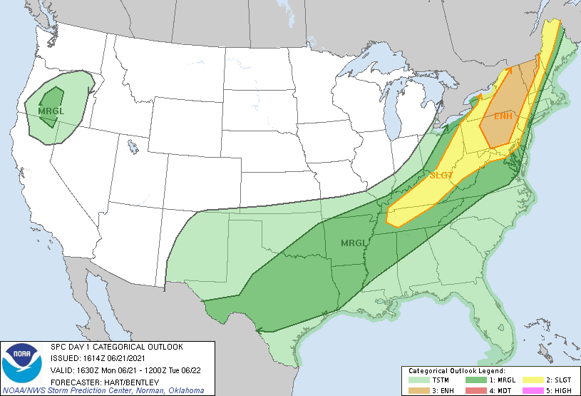
Day 1 Convective Outlook NWS Storm Prediction Center Norman OK 1114 AM CDT Mon Jun 21 2021 Valid 211630Z - 221200Z ...THERE IS AN ENHANCED RISK OF SEVERE THUNDERSTORMS THIS AFTERNOON AND EARLY EVENING FROM CENTRAL PENNSYLVANIA INTO VERMONT.... ...SUMMARY... Scattered severe thunderstorms are expected from the upper Ohio Valley and Mid-Atlantic into northern New England, capable of damaging gusts, sporadic severe hail, and perhaps a couple of tornadoes. ...Northeast States... Water vapor imagery shows a broad upper trough digging across the Great Lakes region, with the associated cold front sweeping across southeast Ontario and OH. Mostly clear skies and dewpoints in the 60s to lower 70s ahead of the front, coupled with steep midlevel lapse rates shown on 12z raobs and model forecast soundings will yield a moderately unstable air mass by early afternoon (MLCAPE over 2000 J/kg). It appears thunderstorms will develop by early afternoon along the front - and in the free warm sector to the east. Vertical shear will be sufficient for a mix of multicell and occasional supercell structures, capable of damaging winds and large hail. Low level shear is strongest over Quebec, but may be sufficient over parts of VT/NY for an isolated tornado or two as well. Activity will sweep eastward across the ENH risk area through the early evening, before weakening as it approaches cooler marine-influenced air mass over eastern New England and NJ.
-
Nothing severe with this event imby. Moderate rain with a few CTG strikes. 0.40 in the bucket.
-
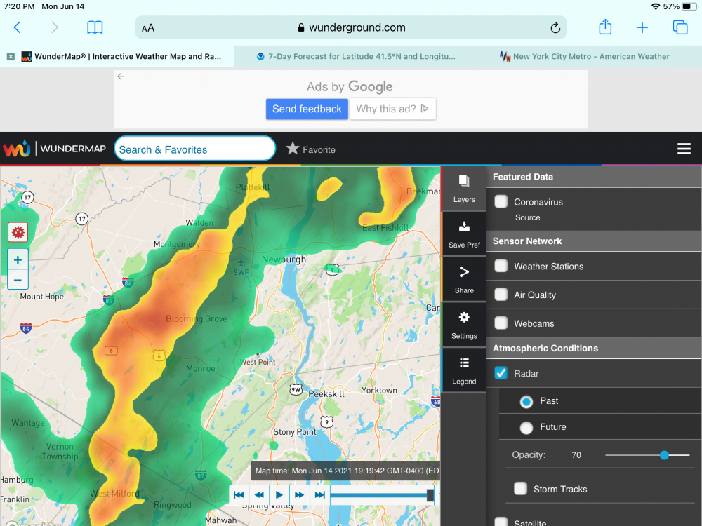
Special Weather Statement National Weather Service New York NY 645 PM EDT Mon Jun 14 2021 A LINE OF STRONG THUNDERSTORMS WILL AFFECT HUDSON...PASSAIC... UNION...BERGEN...ESSEX...NORTHERN WESTCHESTER...ORANGE...PUTNAM AND ROCKLAND COUNTIES... At 645 PM EDT, radar indicated strong thunderstorms were located along a line extending from near Kerhonkson to High Bridge. Movement was east at 30 mph. Wind gusts up to 50 mph and pea size hail are possible with these storms. This includes the following New York State COVID tent site Anthony Wayne Rec Center. Torrential rainfall is also occurring with these storms, and may cause localized flooding. Do not drive your vehicle through flooded roadways. These storms may intensify, so be certain to monitor local radio stations and available television stations for additional information and possible warnings from the National Weather Service.
-
0.02
-

-
Bad day for the beach. No sun, not much fun.
-

-

-
Can you have someone verify that
-
70/48 with mostly cloudy skies currently. Refreshing
-
2021 North Atlantic hurricane forecast contest
hudsonvalley21 replied to Roger Smith's topic in Tropical Headquarters
21/11/6 -
DCA: 100 NYC: 100 BOS: 99 ORD: 100 BIS: 106 ATL: 99 IAH: 103 DEN: 103 PHX: 120 SEA: 99
-
A trace of a trace here (about 5 drops)
-
They really pulsed down when moving west to east.
-
Sorry to hear that. Hopefully you have no loss or damage. The storms really pulsed down when they reached here. Nothing severe here at all light rain and a few rumbles. Total in the rain gauge so far is 0.32.
-
Impressive. It’s slowly drifting to the east
-
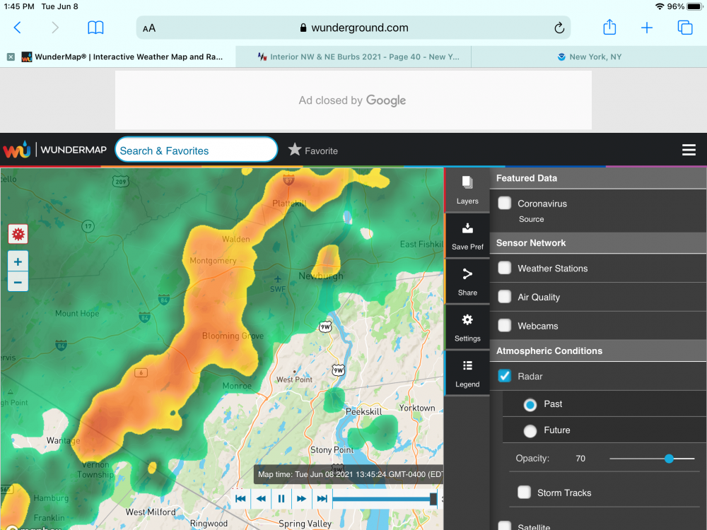
No hail here, had a heavy downpour with a few rumbles. 0.19 with round 1. More on the way. Special Weather Statement National Weather Service New York NY 1249 PM EDT Tue Jun 8 2021 NYZ067-068-081730- Putnam-Orange- 1249 PM EDT Tue Jun 8 2021 ...AN AREA OF STRONG THUNDERSTORMS WILL AFFECT NORTHEASTERN ORANGE AND WESTERN PUTNAM COUNTIES... At 1249 PM EDT, strong thunderstorms were clustered over Goshen, moving northeast at 20 mph. Wind gusts of 50 to 55 mph and nickel size hail are possible with this storm. Locations impacted include... Newburgh, Monroe, West Point, Goshen, Cold Spring, New Windsor, Gardnertown, Chester, Montgomery, Florida, Kiryas Joel, Woodbury, Orange Lake, Mechanicstown and Washingtonville. Torrential rainfall is also occurring with this storm, and may cause localized flooding. Do not drive your vehicle through flooded roadways. Frequent cloud to ground lightning is occurring with this storm. Lightning can strike 10 miles away from a thunderstorm. Seek a safe shelter inside a building or vehicle. This storm may intensify, so be certain to monitor local radio stations and available television stations for additional
-
Low of 72 here. Couldn’t imagine not having a/c and feel for ones that that don’t in these conditions. Currently 75/73.
-
Trace here about 10 raindrops. 0.00 in the bucket.


