hudsonvalley21
-
Posts
4,248 -
Joined
-
Last visited
Content Type
Profiles
Blogs
Forums
American Weather
Media Demo
Store
Gallery
Everything posted by hudsonvalley21
-
3.04 here.
-
2.02 here for the day so far. Steady westerly wind around 15 mph currently.
-
2.02 here. A little breezy, westerly winds steady around 15 mph.
-
Totally agree. Will be sleeping with one eye open tonight.
-
Yup, agree with the enhancement. With the slow movement , I think it’s spin and dump time here
-
Agree. Gave a chance for some to runoff or be absorbed. Pouring here now too.
-
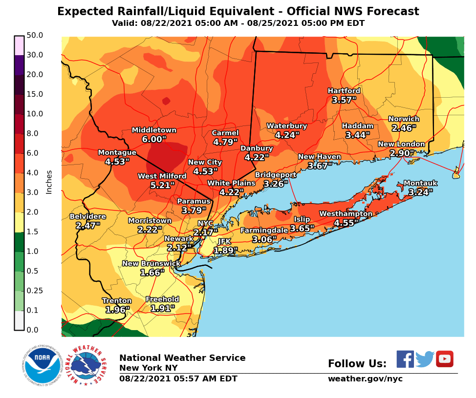
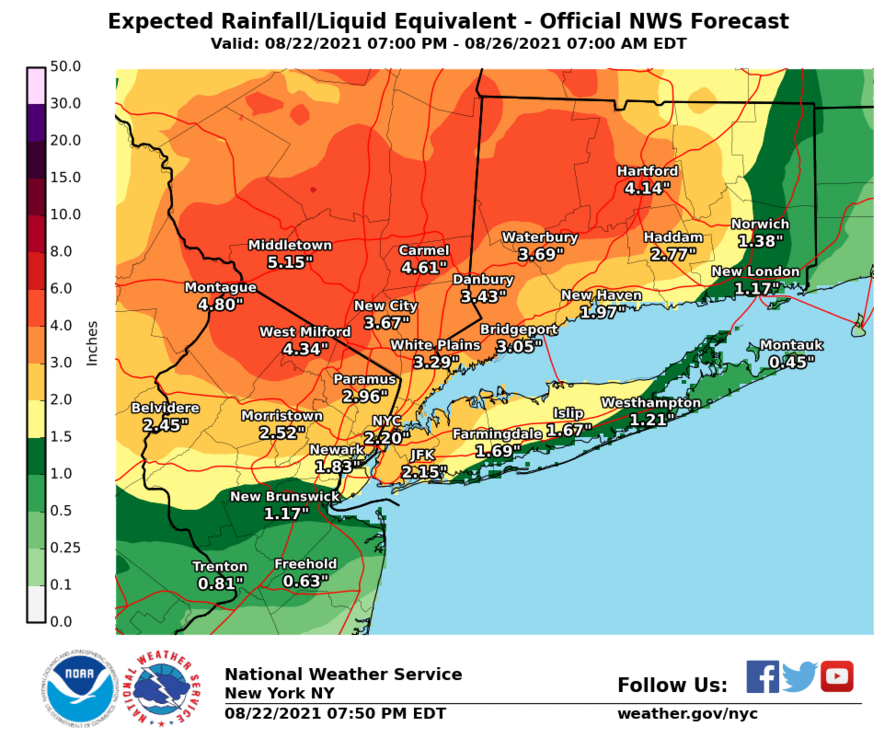
1.55 here so far. Upton’s QPF map form 7pm tonight thru Thursday. So I assume they are throwing this on top what’s already fallen.
-
Upton’s Latest QPF map. I assume they are forecasting this is on top what has already fallen.

- 1,603 replies
-
- 2
-

-
- hurricane gusts
- flooding rains
- (and 2 more)
-
230600- Tropical Storm Henri Local Statement Advisory Number 28 National Weather Service New York NY AL082021 548 PM EDT Sun Aug 22 2021 This product covers Southeast New York, Northeast New Jersey, and Southern Connecticut **HENRI WEAKENS A LITTLE MORE WHILE MOVING WEST-NORTHWESTWARD ACROSS CENTRAL CONNECTICUT** NEW INFORMATION --------------- * CHANGES TO WATCHES AND WARNINGS: - The Tropical Storm Warning has been cancelled for Northeast Suffolk, Northern Fairfield, Northern Middlesex, Northern Nassau, Northern New Haven, Northern New London, Northern Westchester, Northwest Suffolk, Southeast Suffolk, Southern Fairfield, Southern Middlesex, Southern Nassau, Southern New Haven, Southern New London, Southern Westchester, and Southwest Suffolk * CURRENT WATCHES AND WARNINGS: - None * STORM INFORMATION: - About 100 miles northeast of New York City NY or about 50 miles northwest of Montauk Point NY - 41.6N 72.4W - Storm Intensity 40 mph - Movement West-northwest or 290 degrees at 7 mph SITUATION OVERVIEW ------------------ At 5 PM EDT, the center of Tropical Storm Henri was located near Colchester CT. Henri is moving toward the west-northwest near 7 mph, and on its forecast track, Henri is expected to slow down further and possibly stall near the Connecticut-New York border tonight, then move across northern Connecticut or southern Massachusetts by Monday afternoon. The main threat from Henri is now heavy rain capable of producing flash flooding. The threat of rough seas, high surf, and dangerous rip currents continues at the ocean beaches. Widespread rainfall of 3 to 6 inches is forecast in the path of Henri with localized higher amounts possible. The highest amounts are forecast to occur across the lower Hudson Valley western Connecticut, and northeast New Jersey.
-
That deathband that has set up east to west along the NY/NJ border and lower westchester is causing some mayhem down in your area. Flash Flood Warning National Weather Service New York NY 451 PM EDT Sun Aug 22 2021 The National Weather Service in Upton has issued a * Flash Flood Warning for... Bergen County in northeastern New Jersey... Northern Essex County in northeastern New Jersey... Passaic County in northeastern New Jersey... Bronx County in southeastern New York... New York (Manhattan) County in southeastern New York... Southeastern Orange County in southeastern New York... Rockland County in southeastern New York... Southern Westchester County in southeastern New York... * Until 845 PM EDT. * At 451 PM EDT, Doppler radar indicated heavy rain across the warned area. Between 2 and 4 inches of rain have fallen. Additional rainfall amounts of 2 to 4 inches are possible in the warned area. Flash flooding is ongoing or expected to begin shortly.
-
0.91 in the bucket so far.
-
SHORT TERM /6 PM THIS EVENING THROUGH MONDAY NIGHT/... Henri will track northwest into southern New England Sunday into Sunday night, shifting the heavy rain into southwest Connecticut and the Lower Hudson Valley during through Monday. A widespread rainfall of 5 to 10 inches is possible as Henri losses forward speed as it begins to be absorbed into the upper level trough. Upper level southerly jet extending south of the region into the Atlantic will help provide a tropical rich moisture source with layer precipitable waters remaining near 2 inches tonight into early Monday. The flood watch for the entire region has been extended in time until 8 PM EDT Monday night to cover the lingering rainfall into Monday as well as residual runoff and river flooding anticipated. The day 2 outlook for WPC has the area in a slight risk for excessive rainfall. The potential is there for long fused minor river flooding for down stream rivers such as the Passaic, Saddle, and Housatonic Rivers. This situation will have to be monitored throughout the day Monday for updates as much is dependent on the exact location of heaviest rainfall.
-
Could have some serious flooding issues in our neck of the woods later.

-
Thanks Walt us inland folks could have some serious flooding issues here later.
- 1,603 replies
-
- 1
-
-
- hurricane gusts
- flooding rains
- (and 2 more)
-
SHORT TERM /6 PM THIS EVENING THROUGH MONDAY NIGHT/... Henri will track northwest into southern New England Sunday into Sunday night, shifting the heavy rain into southwest Connecticut and the Lower Hudson Valley during through Monday. A widespread rainfall of 5 to 10 inches is possible as Henri losses forward speed as it begins to be absorbed into the upper level trough. Upper level southerly jet extending south of the region into the Atlantic will help provide a tropical rich moisture source with layer precipitable waters remaining near 2 inches tonight into early Monday. The flood watch for the entire region has been extended in time until 8 PM EDT Monday night to cover the lingering rainfall into Monday as well as residual runoff and river flooding anticipated. The day 2 outlook for WPC has the area in a slight risk for excessive rainfall. The potential is there for long fused minor river flooding for down stream rivers such as the Passaic, Saddle, and Housatonic Rivers. This situation will have to be monitored throughout the day Monday for updates as much is dependent on the exact location of heaviest rainfall.
-
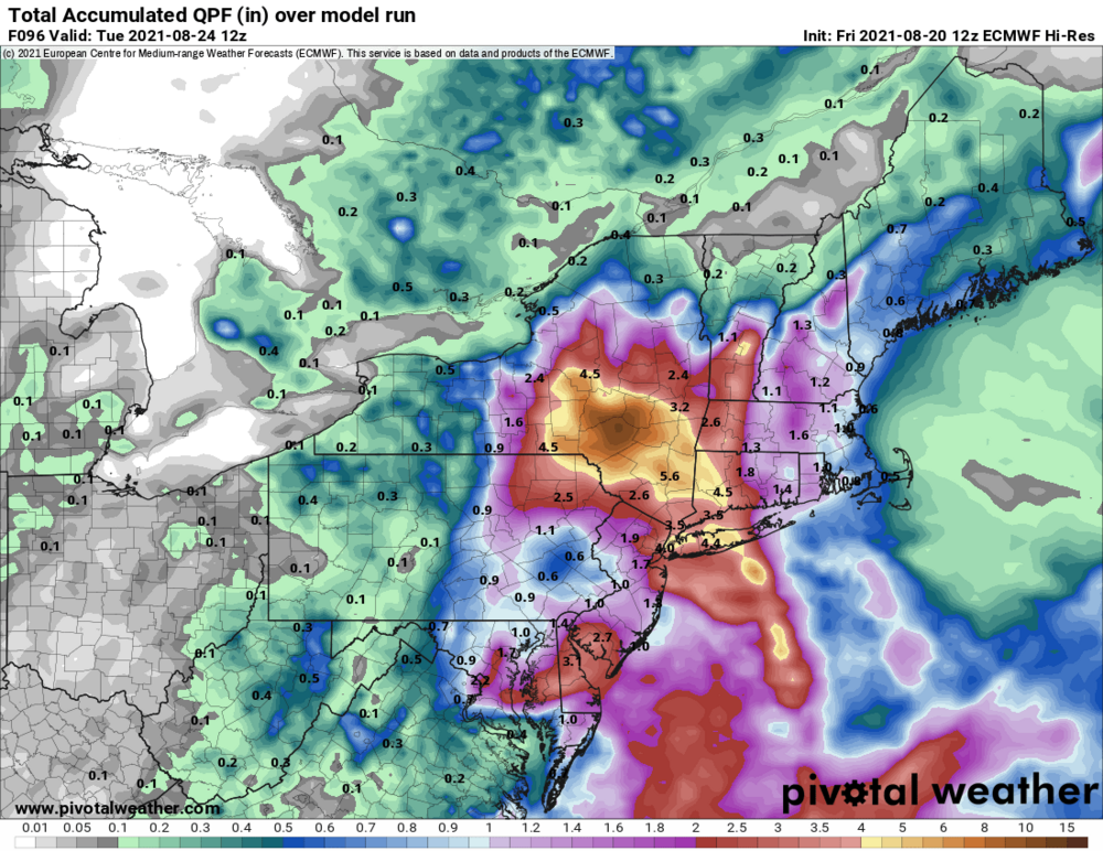
Don’t mean to split hairs, the euro QPF map’s bullseye is around Stamford, Ny, that is in Delaware county and in the Catskills.
-
Still a few runs to go. That QPF map will fluctuate with location and amounts.
-
-
Totally agree
-
Recent euro run was spitting out about a foot of rain in the Catskills area. Definitely a catastrophic flooding possibility. Plus recent rains from Fred’s passing thru has the ground loaded with moisture already.
-
Agree. Also rains from Fred has the ground saturated in spots. Areas along the Delaware River would have some catastrophic flooding with that much QPF.
-
Tropical Storm Henri Discussion Number 19 NWS National Hurricane Center Miami FL AL082021 1100 AM EDT Fri Aug 20 2021 The Air Force Reserve Hurricane Hunters investigated Henri this morning and based on the flight-level, SFMR, and dropsonde data, the initial intensity is still around 55 kt. The minimum pressure has also been relatively steady. The low-level center of Henri is located close to the northwestern edge of the main area of deep convection, and the vortex is still not vertically aligned due to 20-25 kt of northerly vertical wind shear. Although the intensity of Henri has not changed much during the past couple of days, satellite images show an improving cloud pattern with well- established outflow in the eastern semicircle, which could indicate that Henri is poised to strengthen. There is some uncertainty in the exact position of Henri given the recent aircraft fixes and the tilt of the vortex, but the initial motion appears to be northwestward at 6 kt. A trough over the central Appalachians is expected to cut off tonight, and the combination of that feature and a building ridge to the east/northeast of Henri should cause the storm to turn northward tonight and accelerate in that direction on Saturday. Some of the models show a slight bend to the west around the time Henri is forecast to make landfall on Sunday, and there remains a fair amount spread in the guidance in where the center of Henri will come ashore. The latest GFS and ECMWF ensemble members span a region from near New York City to Cape Cod for the landfall point. Based on the latest consensus aids and initial position, the official track forecast is nudged to the west of the previous one and shows landfall occurring by late Sunday. After day 3, Henri is forecast to eject northeastward across the Gulf of Maine.
- 1,603 replies
-
- 1
-
-
- hurricane gusts
- flooding rains
- (and 2 more)
-
BULLETIN Tropical Storm Henri Advisory Number 19 NWS National Hurricane Center Miami FL AL082021 1100 AM EDT Fri Aug 20 2021 ...AIR FORCE HURRICANE HUNTERS FIND HENRI STEADY IN STRENGTH... ...STORM SURGE AND HURRICANE WATCHES ARE IN EFFECT FOR PORTIONS OF THE NORTHEASTERN UNITED STATES... SUMMARY OF 1100 AM EDT...1500 UTC...INFORMATION ----------------------------------------------- LOCATION...30.4N 73.7W ABOUT 345 MI...560 KM SSE OF CAPE HATTERAS NORTH CAROLINA ABOUT 745 MI...1200 KM S OF MONTAUK POINT NEW YORK MAXIMUM SUSTAINED WINDS...65 MPH...100 KM/H PRESENT MOVEMENT...NW OR 305 DEGREES AT 7 MPH...11 KM/H MINIMUM CENTRAL PRESSURE...996 MB...29.42 INCHES WATCHES AND WARNINGS -------------------- CHANGES WITH THIS ADVISORY: The Storm Surge Watch has been extended slightly westward to Flushing, New York, including adjacent areas of western Long Island Sound and the East River. SUMMARY OF WATCHES AND WARNINGS IN EFFECT: A Storm Surge Watch is in effect for... * South Shore of Long Island from East Rockaway Inlet to Montauk * North Shore of Long Island from Kings Point to Montauk * Flushing New York to Sagamore Beach Massachusetts * Nantucket, Martha's Vineyard, and Block Island A Hurricane Watch is in effect for... * South Shore of Long Island from Fire Island Inlet to Montauk * North Shore of Long Island from Port Jefferson Harbor to Montauk * New Haven Connecticut to Sagamore Beach Massachusetts * Nantucket, Martha's Vineyard, and Block Island A Tropical Storm Watch is in effect for... * West of Fire Island Inlet to East Rockaway Inlet New York * West of Port Jefferson Harbor New York * West of New Haven Connecticut
-
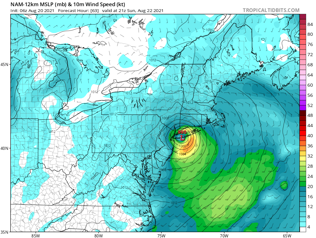
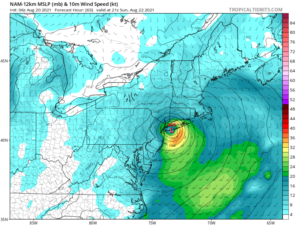
06z NAM has it coming on land in central/western LI and spinning up into the Hudson valley
- 1,603 replies
-
- 1
-

-
- hurricane gusts
- flooding rains
- (and 2 more)