hudsonvalley21
-
Posts
4,265 -
Joined
-
Last visited
Content Type
Profiles
Blogs
Forums
American Weather
Media Demo
Store
Gallery
Everything posted by hudsonvalley21
-
Wow impressive. the flood advisory posted I think has a typo in it. It should read 1-2 inches has fallen not 1/2. Flood Advisory National Weather Service New York NY 825 PM EDT Sat Jul 17 2021 NJC003-NYC071-079-087-119-180215- /O.NEW.KOKX.FA.Y.0075.210718T0025Z-210718T0215Z/ /00000.N.ER.000000T0000Z.000000T0000Z.000000T0000Z.OO/ Bergen NJ-Orange NY-Putnam NY-Rockland NY-Westchester NY- 825 PM EDT Sat Jul 17 2021 The National Weather Service in Upton has issued a * Urban and Small Stream Flood Advisory for... North Central Bergen County in northeastern New Jersey... Southeastern Orange County in southeastern New York... Putnam County in southeastern New York... Rockland County in southeastern New York... Northern Westchester County in southeastern New York... * Until 1015 PM EDT. * At 825 PM EDT, Doppler radar indicated heavy rain from thunderstorms capable of causing urban and small stream flooding. Between 1/2 and inches of rain has already fallen. * Some locations that could experience flooding include... New City, Ossining, Peekskill, Monsey, Nanuet, Haverstraw, Tarrytown, Mount Kisco, Suffern, Mahopac, Lake Carmel, Nyack, West Point, Sherman, Sloatsburg, Brewster, Cold Spring, Pearl River, New Fairfield and Carmel. Additional rainfall of 1/4 to 1/2 inch is likely over the area.
-
Our luck it would all be ZR.
-
Having another thunderstorm now 2nd one of the day. Only have 0.41 in the bucket so far. Had a rain rate of 4.17 a few minutes ago.
-
And the discussion with the map below. We’ll see what they have in the next update. SPC AC 161728 Day 2 Convective Outlook NWS Storm Prediction Center Norman OK 1228 PM CDT Fri Jul 16 2021 Valid 171200Z - 181200Z ...THERE IS A MARGINAL RISK OF SEVERE THUNDERSTORMS ACROSS PARTS OF THE NORTHEAST/MID-ATLANTIC AND THE NORTHERN/CENTRAL PLAINS... ...SUMMARY... Isolated strong to severe storms will be possible across portions of the Northeast/Mid-Atlantic and northern/central Plains on Saturday. ...Northeast/Mid-Atlantic... A belt of modestly enhanced mid-level southwesterly flow should be maintained Saturday across much of the Northeast and Mid-Atlantic ahead of a positively tilted upper trough. At the surface, a weak low is forecast to develop from the lower Great Lakes across NY and into southern New England by Saturday evening. A cold front should extend southwestward from this surface low across the Mid-Atlantic and into the central Appalachians, while a weak warm front extends across southern NY and southern New England. Current expectations are for multiple clusters of storms to develop along/ahead of the cold front and a pre-frontal trough through the day, and subsequently move eastward across the warm sector. Low/mid-level flow should not be overly strong, but generally 20-30 kt of deep-layer shear should be sufficient for modest updraft organization and mainly a multicell/cluster storm mode. Daytime heating of the moist low-level airmass ahead of these storms will likely foster steepened low-level lapse rates and moderate to strong instability, particularly across the Mid-Atlantic east of the Appalachian and Blue Ridge Mountains. Isolated damaging wind gusts should be the main threat. Both low-level and deep-layer shear may be slightly stronger across southern NY/New England, and marginal supercells posing both an damaging wind and brief tornado threat appear possible, particularly in the vicinity of the weak warm front. Upton's AFD, Area Forecast Discussion National Weather Service New York NY 1104 PM EDT Fri Jul 16 2021 .SYNOPSIS... A slow moving frontal boundary will stall across the area tonight, then lift northward as a warm front on Saturday. A separate weak cold front will then slowly approach from the west Saturday night, move across on Sunday, and pass slowly east on Monday. Another weak frontal boundary will approach on Wednesday. Weak high pressure will then build in for Thursday and Friday. && .NEAR TERM /UNTIL 6 AM SATURDAY MORNING/... Frontal boundary remains across the area overnight. As a result, light and variable winds and high humidity will keep low temperatures in the upper 60s to mid 70s. Expect fog to develop again across eastern Connecticut and Long Island, perhaps even more widespread compared to previous nights as winds decrease and/or go calm in the vicinity of the frontal boundary. The 00Z NamNest shows an area of convection blossoming across south central PA and working NE into the area during the early morning hours. Latest HRRR, FV3, ARW, don`t support this scenario. However, latest regional radar does show development in this area, even ahead of the NamNest timing. There is little if any upper forcing with the main lift being provided by the surface boundary. So, have my doubts to the longevity of this convection. Simply put, it will have to watched and chances may need to be increased should this area continue to hold together the next several hours. Regardless, the potential exists for at least isolated showers/thunderstorms overnight. && .SHORT TERM /6 AM SATURDAY MORNING THROUGH SATURDAY NIGHT/... A flash flood watch remains in effect for portions of the area for Saturday afternoon and night. As high pressure shifts offshore and a frontal wave approaches from the west, moisture advection will allow PWAT values to increase to above 2 inches. Despite a general forward motion of the storms around 20-30 kt, heavy rainfall combined with antecedent wet conditions due to previous rainfall will lead to an increased threat of flash flooding across the areas within the watch. The period of greatest potential will be from roughly 8 pm into the overnight. Additionally, storms will be capable of gusty winds and perhaps brief rotation, especially in the vicinity of the surface low and to the north. Otherwise, onshore flow and cloud cover will lead to cooler temperatures compared to previous days, though with dew points remaining high, heat indices will still be above 95 across New Jersey, NYC, and western Long Island.
-
I would do a light trimming.

-
It looks like the rouge cell to the south got absorbed into the line now. Hopefully that will kill the rotation.
-
Have an elderly relative in Pearl River. Watching the radar too. Good luck down there
-
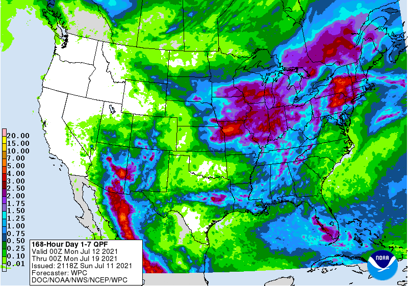
WPC’s 7 day QPF map might have to be adjusted upwards.
-
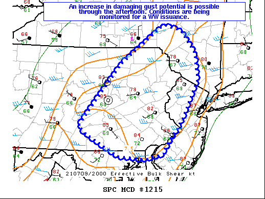
Can we make it 4 days in a row? Mesoscale Discussion 1215 NWS Storm Prediction Center Norman OK 0335 PM CDT Fri Jul 09 2021 Areas affected...portions of southeast New York into eastern Pennsylvania...far northeast Maryland...western New Jersey Concerning...Severe potential...Watch possible Valid 092035Z - 092230Z Probability of Watch Issuance...40 percent SUMMARY...The severe threat continues to increase across portions of the Mid Atlantic this afternoon. Damaging gusts remain the primary threat with the stronger, longer-lived storms. Conditions will continue to be monitored for the need of a Severe Thunderstorm Watch issuance. DISCUSSION...Multicellular clusters, evident via MRMS mosaic radar imagery, have demonstrated small, bow-type structures over the past hour or so, with some damaging gusts reported. These storms are progressing in an environment characterized by widespread, poor mid-level lapse rates, but with 7+ C/km 0-3km lapse rates (evident via 20Z mesoanalysis and 19Z RAP forecast soundings). The aforementioned low-level lapse rates atop upper 60s to 70 F surface dewpoints are contributing to 1000-1500 J/kg MLCAPE amid 40+ kt effective bulk shear. These bulk shear vectors are oriented roughly perpendicular to the smaller linear segments. As such, storms are expected to continue supporting damaging gust potential through the remainder of the diurnal heating cycle. It is unclear how widespread the damaging gust threat will be through the remainder of the afternoon. Conditions will continue to be monitored for the need of a Severe Thunderstorm Watch issuance should it become evident that more widespread damaging gusts will become likely. ..Squitieri/Bunting.. 07/09/2021
-
1.19 in the bucket for the day as of 10:30 pm.
-
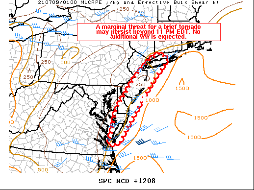
Mesoscale Discussion 1208 NWS Storm Prediction Center Norman OK 0901 PM CDT Thu Jul 08 2021 Areas affected...Chesapeake Bay Vicinity Concerning...Tornado Watch 350... Valid 090201Z - 090300Z The severe weather threat for Tornado Watch 350 continues. SUMMARY...A marginal threat for a brief tornado may continue along the immediate Atlantic coast beyond the expiration of Tornado Watch 350. No additional WW is expected this evening. DISCUSSION...The strongest convection in WW 350 has continued to move offshore in eastern North Carolina and Virginia. Farther inland, there has been little notable low-level rotation on regional radar imagery. As tropical storm Elsa continues northeast this evening, an isolated stronger convective cell could develop along the gulf stream and move inland. While low-level winds could still support a brief tornado, the unfavorable low-level thermodynamic environment -- especially inland of the immediate coast -- suggests that this threat will be marginal. No additional watches are anticipated this evening.
-
Not that I can remember for the severe thunderstorm watch. 0.57 in the bucket today so far. a section from today’s outlook from the SPC Northeast States... Clusters of showers/thunderstorms are ongoing at midday across the region, particularly across far southeast New York into western New England. More considerable cloud cover is also generally prevalent across the region as compared to prior days. More appreciable destabilization will tend to remain confined to the Chesapeake/DE Bays towards the New York City tri-state area, where some cloud breaks are noted within morning visible satellite imagery. Although the degree of destabilization is a bit uncertain, isolated severe thunderstorms will be possible across the region with thunderstorm wind damage as the primary severe risk. Areas such as northeast PA/northern NJ into southern NY/NYC Metro and southern New England will continue to be reevaluated and monitored for a somewhat greater severe risk later today, which could include potential for some transient supercells

-
SPC AC 081819 Day 1 Convective Outlook CORR 2 NWS Storm Prediction Center Norman OK 0119 PM CDT Thu Jul 08 2021 Valid 081630Z - 091200Z Northeast States... Clusters of showers/thunderstorms are ongoing at midday across the region, particularly across far southeast New York into western New England. More considerable cloud cover is also generally prevalent across the region as compared to prior days. More appreciable destabilization will tend to remain confined to the Chesapeake/DE Bays towards the New York City tri-state area, where some cloud breaks are noted within morning visible satellite imagery. Although the degree of destabilization is a bit uncertain, isolated severe thunderstorms will be possible across the region with thunderstorm wind damage as the primary severe risk. Areas such as northeast PA/northern NJ into southern NY/NYC Metro and southern New England will continue to be reevaluated and monitored for a somewhat greater severe risk later today, which could include potential for some transient supercells
-
Same here from the overnight 0.03. Some loud thunder but that was basically it.
-
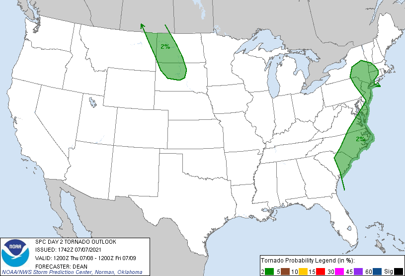
Could be on the menu. Day 2 Convective Outlook NWS Storm Prediction Center Norman OK 1242 PM CDT Wed Jul 07 2021 ...Portions of the Northeast/southern New England... Scattered thunderstorm development is expected by Thursday afternoon in a weakly capped environment across eastern PA and NJ, and also potentially along a warm front into portions of southern New England. Modestly enhanced southwesterly midlevel flow may support some organized clusters capable of producing locally damaging wind. A supercell or two cannot be ruled out in the vicinity of the warm front, which would pose a threat of a tornado or two in addition the damaging wind potential.
-
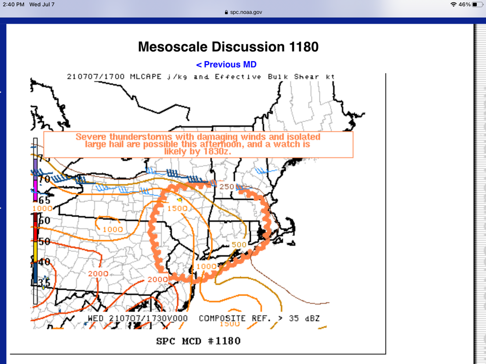
Mesoscale Discussion 1180 NWS Storm Prediction Center Norman OK 1250 PM CDT Wed Jul 07 2021 Areas affected...Northeast PA...southeast NY...southern VT...MA...CT...RI...northern NJ Concerning...Severe potential...Watch likely Valid 071750Z - 071945Z Probability of Watch Issuance...80 percent SUMMARY...Thunderstorms will increase in coverage this afternoon and be capable of damaging downburst winds and isolated instances of large hail. A Severe Thunderstorm Watch will be needed prior to 1830z. DISCUSSION...Latest surface analysis showed a stationary front extending from near the MA/NH border west to near the eastern tip of Lake Erie. Strong diabatic heating of a very moist (upper 60s-lower 70s surface dew points) air mass continues south of the front, contributing to MLCAPE ranging from 1000-2000 J/kg. The discussion area is on the southern periphery of stronger mid-level westerly flow, and this will contribute to effective shear values ranging from 25-35 kts. Largely southwest/west flow in the low-mid levels will support multicells and clusters as the primary modes. Steep low-level lapse rates and a very moist environment will support damaging downburst winds as the primary hazard, especially as storm coverage/clustering increases later this afternoon. A few instances of large hail will be possible, especially with the strongest multicell updrafts. Convective trends are being monitored and a Severe Thunderstorm Watch is likely prior to 1830z. ..Bunting/Guyer.. 07/07/2021
-
I had dozens of Japanese beetles drowned in my pool each day the last two days. Dodged the heavy thunderstorms yesterday and had 0.18 in the bucket for the day.
-
In addition, the park rangers will ticket you. They also pose as regular people in canoes in their stealth mode.
-
Enjoy!
-
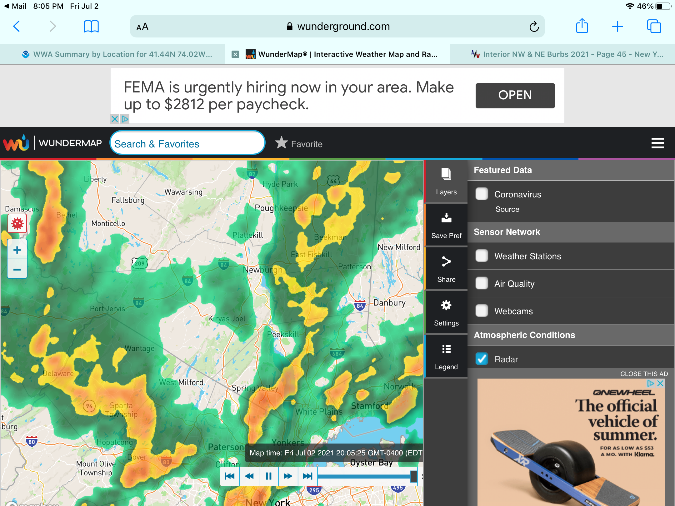
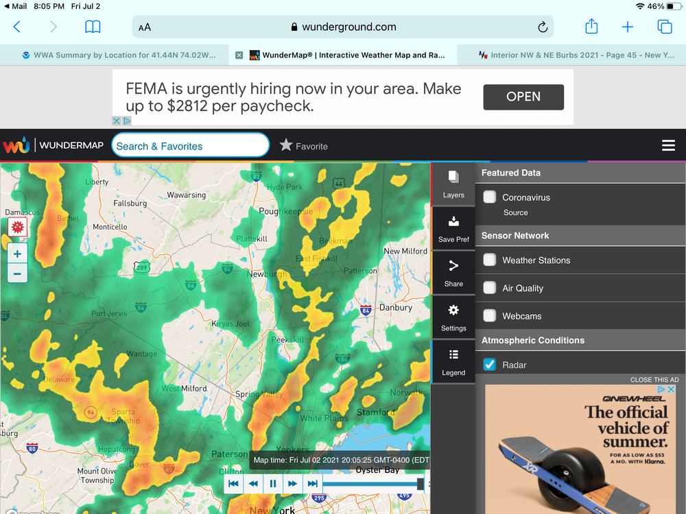
0.63 in the bucket so far today. Appears that we might get some more. Most of the below is moving to the n/ne. Screenshot at 8:00 pm.
-
-
July 2021 temperature forecast contest
hudsonvalley21 replied to Roger Smith's topic in Weather Forecasting and Discussion
DCA: +2.2 NYC: +1.7 BOS: +1.9 ORD: +1.3 ATL: +0.8 IAH: +0.2 DEN: +1.4 PHX: +1.3 SEA: +1.4 -
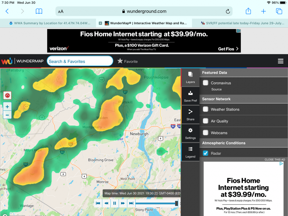
I was near KSWF about 30 minutes ago and had winds around 40 from the outflow with the stronger cell to the north. looks like a line trying to form currently. Severe Thunderstorm Warning NYC071-010000- /O.NEW.KOKX.SV.W.0028.210630T2312Z-210701T0000Z/ BULLETIN - IMMEDIATE BROADCAST REQUESTED Severe Thunderstorm Warning National Weather Service New York NY 712 PM EDT Wed Jun 30 2021 The National Weather Service in Upton NY has issued a * Severe Thunderstorm Warning for... Northeastern Orange County in southeastern New York... * Until 800 PM EDT. * At 712 PM EDT, a severe thunderstorm was located near Montgomery, or near Walden, moving northeast at 35 mph. HAZARD...60 mph wind gusts and penny size hail. SOURCE...Radar indicated. IMPACT...Expect damage to trees and power lines. * This severe thunderstorm will be near... Montgomery around 715 PM EDT. Walden around 725 PM EDT. New Windsor and Gardnertown around 730 PM EDT. Newburgh around 735 PM EDT.