-
Posts
1,013 -
Joined
-
Last visited
Content Type
Profiles
Blogs
Forums
American Weather
Media Demo
Store
Gallery
Everything posted by jconsor
-

2023 Atlantic Hurricane season
jconsor replied to Stormchaserchuck1's topic in Tropical Headquarters
-

2023 Atlantic Hurricane season
jconsor replied to Stormchaserchuck1's topic in Tropical Headquarters
The system near the Bahamas has maintained healthy outflow aloft and some mid-level spin on satellite for at least 24 hours, though convection has waxed and waned. I wrote about the potential for this system (or a few others trailing it) to take advantage of favorable light shear in the Gulf of Mexico next week and possibly become "surprise" TCs. -

2023 Atlantic Hurricane season
jconsor replied to Stormchaserchuck1's topic in Tropical Headquarters
Some important context re: the ECMWF seasonal outlook. Firstly, as others have pointed out, the Aug outlook is for Sep onward. So if we were to have an active Aug, that would be not be reflected in the ECMWF outlook. I go through some other important points to keep in mind in this thread: -

2023 Atlantic Hurricane season
jconsor replied to Stormchaserchuck1's topic in Tropical Headquarters
The Euro weeklies almost never show any chance for hurricanes (>5% on those maps) in my experience. More relevant to look at tropical depression *anomaly* probability and TS probability. -

2023 Atlantic Hurricane season
jconsor replied to Stormchaserchuck1's topic in Tropical Headquarters
Regarding the Bahamas/FL system... yes, pressures are high and this will need some time to "cook" before developing. However, it going just inland next day or two is not a guarantee against a TD or weak TS developing. We have seen such systems develop even with little model support a few times in the recent past. There is another brief window for development early next week as it heads back offshore and passes near the Gulf Stream: -

2023 Atlantic Hurricane season
jconsor replied to Stormchaserchuck1's topic in Tropical Headquarters
A thread about the East Atlantic system. I think the it has a decent chance for development (I would say 50-60% within 7 days). Don't be fooled by recency bias just because 95L encounted hostile conditions and didn't develop. The atmospheric state has changed substantially in a way that favors development more for this wave than it did for 95L. -

2023 Atlantic Hurricane season
jconsor replied to Stormchaserchuck1's topic in Tropical Headquarters
Don't sleep on 95L. It looks sheared and convectively anemic at the present time, but could gain renewed energy in the W. Caribbean. -

2023 Atlantic Hurricane season
jconsor replied to Stormchaserchuck1's topic in Tropical Headquarters
Be careful using the CFS for assessing how favorable/unfavorable the Atlantic will be for tropical activity in the subseasonal to seasonal timeframe (2 weeks to several months out). Its recent performance has been awful. Copernicus multi-model ensemble and ECMWF weeklies are more reliable tools. -

2023 Atlantic Hurricane season
jconsor replied to Stormchaserchuck1's topic in Tropical Headquarters
Thread about the next potential MDR/central Atlantic system. Of course it's very early and the system isn't expected to form for another 5-7 days, but I though it's worth discussing potential track. I'm not so sure this will form as early as ensembles imply. Given the indications of a weakening E US trough/building W Atl ridge first week of Aug, this could work against a clean recurve out to sea. -

2023 Atlantic Hurricane season
jconsor replied to Stormchaserchuck1's topic in Tropical Headquarters
Need to watch for possible development near the SE US coast late this week into this weekend. -

2023 Atlantic Hurricane season
jconsor replied to Stormchaserchuck1's topic in Tropical Headquarters
While the tropical Atlantic will likely remain relatively quiet until at least the last third of the month, the overall atmospheric and oceanic pattern in the month tends to be strongly correlated to the level of activity during the rest of the season and can provide some very important clues to assess the reliability of seasonal guidance. There has been consistency in the guidance on easterly upper-level wind anomalies prevailing much of Jul across much of the Caribbean and tropical central Atlantic, along with significant westerly anomalies at 850 mb in the MDR (as was forecast by the Copernicus multi-model ensemble - see Alex Boreham's excellent site here: https://cyclonicwx.com/models/c3s/atl/). If this verifies, it would be a strong indicator of an active season. -

2023 Atlantic Hurricane season
jconsor replied to Stormchaserchuck1's topic in Tropical Headquarters
Be careful using the EPS weeklies beyond 2-3 weeks to gauge favorability of the overall pattern for Atlantic tropical activity. They have been biased toward too much -VP over the E. Pacific and +VP over Indian Ocean, apparently playing catchup to the lingering impacts of the very warm SST in the tropical W. Pacific and the -PDO, as well as the influence of the strong WAM and very warm tropical Atlantic. -
It is unlikely that in the face of significant easterly anomalies in the central Pacific through mid-Jul, the waning subsurface warmth will be enough to foster any further warming in the Nino 3.4 and 4 regions. If anything, I would expect some slight cooling.
-
https://www.atmos.albany.edu/student/ventrice/real_time/AAM.png Dr. Gensini's site (https://atlas.niu.edu/gwo/) has CFS GWO forecasts at bottom
-
IMHO, We need to look beyond the Central Pacific for indicators on the trajectory of this El Nino event:
-
Thread discussing potential analog years based on moderate to strong east-weighted El Nino, -PDO, warm tropical Atlantic/Canary Current and Wet Sahel. The juxtaposition of relatively strong El Nino on the one hand and -PDO, very warm Atlantic and wet Sahel on the other hand (which generally don't go together with El Nino) is rather rare. Need to go pretty far back in time to find appropriate analogs IMHO:
-
-
I would recommend being wary/skeptical of MJO forecasts showing a shift of the main negative velocity potential cell (and thus a WWB) into the Eastern and Central Pacific. This has been a persistent model bias amongst multiple ensembles (both GEFS and EPS) since Apr.
-

2023 Atlantic Hurricane season
jconsor replied to Stormchaserchuck1's topic in Tropical Headquarters
-
Thread detailing three of the main explanations for the series of recent false El Nino forecast busts or overly strong El Nino forecasts.
-
1997 and 2015 look like poor analogs to this year to me. If anything, 2015 may be an anti-log in many ways in terms of the ENSO/Tropical Atlantic evolution. Doesn't mean the El Nino can't become strong (3-month average Nino 3.4 anomaly above 1.5C), but it will likely be a long and bumpy road toward achieving that (if at all, it would likely be in the last quarter of 2023). In any case, the highly anomalous warmth in the tropical Atlantic would tend to favor a quick weakening and eventual demise of the El Nino in Q1-Q2 2024. https://www.nature.com/articles/ncomms14887 https://www.nature.com/articles/s41612-022-00305-y
-
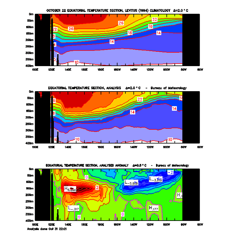
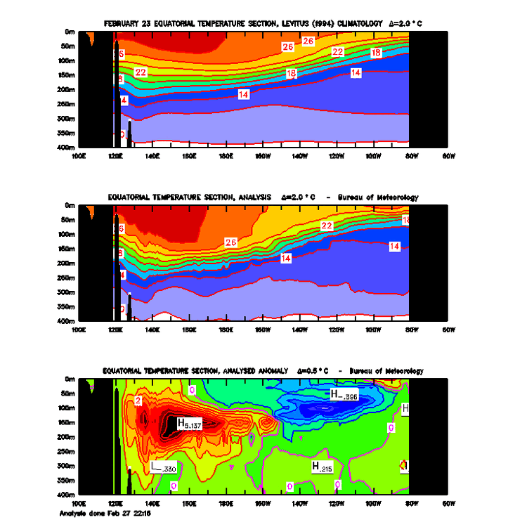
Hi, thanks for the constructive feedback/criticism. I agree my Twitter thread was not well-worded. A better explanation would have been that the extensive subsurface warmth slowly shifting from the dateline area into the central Pacific eroded the cool pool in the E. Pacific and led to surface warming during the fall and winter (see attached SST cross-sections from Oct and Dec '22 and Feb '23), which in turn likely favored a more +AAM state in the atmosphere. FYI, there is some evidence from recent research that upwelling of cold pools below the surface can influence the strength and location of the Walker Circulation, which has a significant influence on the atmospheric pattern across Asia and N. America. It is not hard to envision that upwelling anomalously warm subsurface water could have similar impacts. See https://iopscience.iop.org/article/10.1088/1748-9326/ab7d5e/pdf and https://agupubs.onlinelibrary.wiley.com/doi/full/10.1029/2018GL079494
-
Thread delving into the outsized influence of the subsurface warm pool this late fall-winter, well before water temps at the surface began warming in the eastern equatorial Pacific.
-
Important caveat to keep in mind when interpreting GFS/GEFS guidance:


