jconsor
-
Posts
1,016 -
Joined
-
Last visited
Content Type
Profiles
Blogs
Forums
American Weather
Media Demo
Store
Gallery
Everything posted by jconsor
-
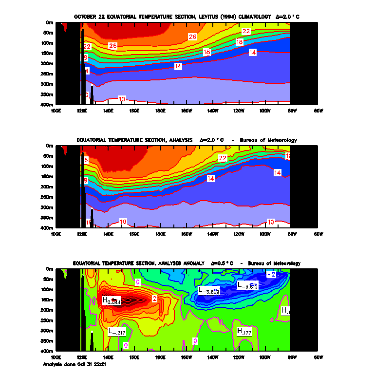
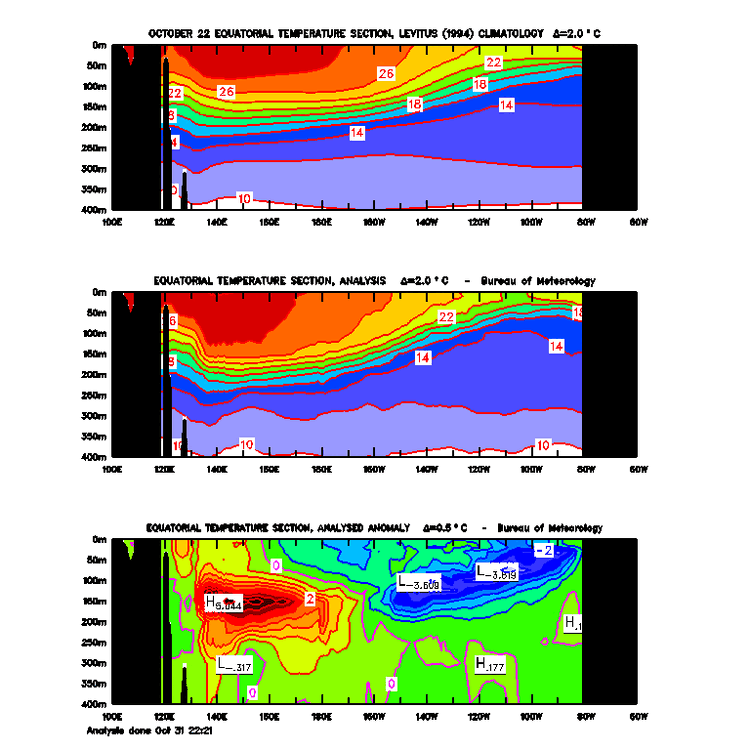
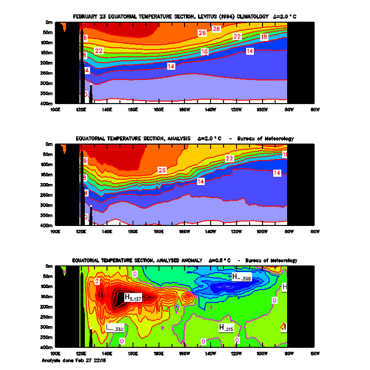
Hi, thanks for the constructive feedback/criticism. I agree my Twitter thread was not well-worded. A better explanation would have been that the extensive subsurface warmth slowly shifting from the dateline area into the central Pacific eroded the cool pool in the E. Pacific and led to surface warming during the fall and winter (see attached SST cross-sections from Oct and Dec '22 and Feb '23), which in turn likely favored a more +AAM state in the atmosphere. FYI, there is some evidence from recent research that upwelling of cold pools below the surface can influence the strength and location of the Walker Circulation, which has a significant influence on the atmospheric pattern across Asia and N. America. It is not hard to envision that upwelling anomalously warm subsurface water could have similar impacts. See https://iopscience.iop.org/article/10.1088/1748-9326/ab7d5e/pdf and https://agupubs.onlinelibrary.wiley.com/doi/full/10.1029/2018GL079494

-
Thread delving into the outsized influence of the subsurface warm pool this late fall-winter, well before water temps at the surface began warming in the eastern equatorial Pacific.
-
Important caveat to keep in mind when interpreting GFS/GEFS guidance:
-
2023 Atlantic Hurricane season
jconsor replied to Stormchaserchuck1's topic in Tropical Headquarters
A thread on why the Sahel rainfall/Atlantic hurricane correlation has waxed and waned, and why the expected wet Sahel/strong W. African monsoon this year is likely an important factor for the hurricane season: -
I think a total fail (no official El Nino designation by Oct) is unlikely. However, the more pertinent question is to what degree the atmosphere will couple with the warm equatorial Pacific if the main warming remains in the far eastern Pacific and ENSO 3.4 region doesn't warm sufficiently. @Bluewave touched on this in a post yesterday. The El Ninos of 1953, 1969 and 2018-2019 didn't couple well to the armosphere, which limited their shearing impact on much of the MDR aside from the southern Caribbean.
-
Here are some of the reasons why I am skeptical of a moderate to strong Nino.
-
Reasons for little eastward progression of the WWB in the western Pacific through early May.
-
2022 Atlantic Hurricane season
jconsor replied to StormchaserChuck!'s topic in Tropical Headquarters
The apparent subtropical system off the NE US coast eventually had a significant impact in the eastern Maritimes of Canada - e. Nova Scotia and Newfoundland. Although it occurred in 2023, to me it seems more of a continuation of the 2022 season so I'll put my thoughts in this thread rather than starting a new one 5.5 months before the 2023 season officially begins :) Little doubt from my perspective this will be declared a subtropical storm post-season. -
Yes, numerous factors support the system off the NE US being subtropical. I explain in the thread below:
-
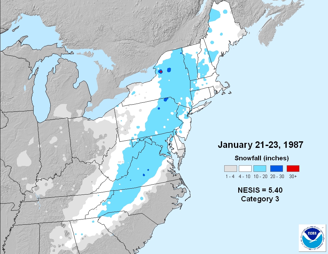
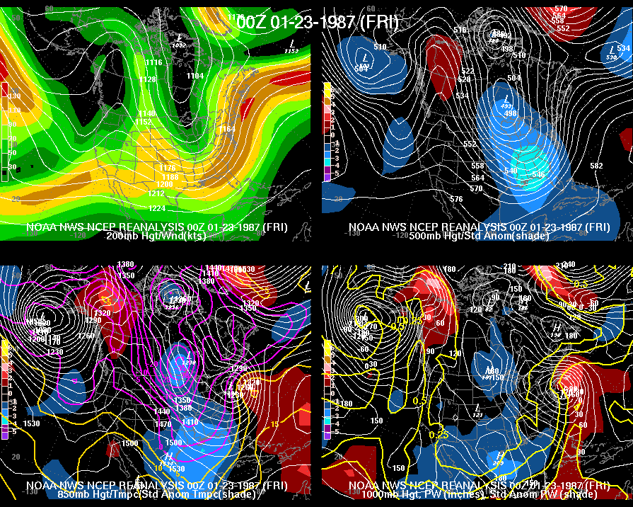
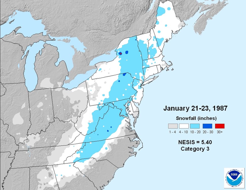
As far as the snowfall in the 1980s that produced 8.6" in NYC and only changed to drizzle at the very end... I think you are talking about the Jan 22, 1987 snowstorm. This was a huge forecast bust and (along with Hurricane Gloria) the storm that got me interested in weather as a young child growing up in Long Island (Roslyn). I was in first grade at the time. I distinctly remember hearing forecasts for a quick slushy inch or two then changing to heavy rain, and being the only child in my school who brought snow boots. I recall that unlike many heavy snow events, there wasn't a couple hours of light snow at the beginning. Nearly from the beginning it just poured down huge flakes and started piling up very quickly (1"+ per hour for many hours). It started snowing in the morning and by the time our school day was supposed to end in mid-afternoon, the snow was coming down too fast for the unprepared plows to keep up (plus there are some significant hills that the school buses in our town need to ascend). Thus we were stuck at school for about six hours! The staff brought up mattresses for us to sleep on the floor of the school gym. In the end we got about 9-10". The Jan 22, 1987 snowstorm paralyzed many areas along the I-95 corridor from DC to NYC (Boston was too far east relative to storm track and quickly changed to rain). It was followed four days later by another heavy snowstorm in the southern and eastern mid-Atlantic.
-
Made a thread on the Sun-Mon potential storm. Highly anomalous patterns - like this one with the near record -NAO and very strong blocking - can produce anomalous/extreme results in terms of sensible weather, if the shortwave timing/phasing is favorable. Note that I show the GEM here because it illustrates the potential for this storm, though I agree with @brooklynwx99 that it likely represents the ceiling of that potential.
-
2022 Atlantic Hurricane season
jconsor replied to StormchaserChuck!'s topic in Tropical Headquarters
I wrote a thread comparing 2022 to other years with a similar oceanic pattern. Like this year, most of these analog years saw activity focused in the western Atlantic basin and had a late start, with little significant activity prior to Aug 20. -
Great post! I was familiar with the impact of Urals blocking/ridging on cold air ejection into the eastern US 7-10 days later, but wasn't aware of the connection to subsequent winter SSWs.
-
2022 Atlantic Hurricane season
jconsor replied to StormchaserChuck!'s topic in Tropical Headquarters
Regarding the performance of seasonal hurricane outlooks and 2022's "low bust" vs NOAA's seasonal outlook, I found this blog interesting: https://www.worldclimateservice.com/2022/11/04/noaa-hurricane-outlook-skill/ -
As a follow-up to the climate shift you mentioned since around 2011, this is interesting:
-
With the huge wind field, there is the potential for historic storm surge flooding in NE FL and coastal GA:
-
2022 Atlantic Hurricane season
jconsor replied to StormchaserChuck!'s topic in Tropical Headquarters
-
2022 Atlantic Hurricane season
jconsor replied to StormchaserChuck!'s topic in Tropical Headquarters
-
The remnants of Ian are becoming a hybrid low near the mid-Atlantic coast with a shallow warm core (mainly 850 mb and above). The interaction between this very slow-moving low and a strong high pressure system over E Canada and the NE US is creating a major, multi-tidal cycle coastal flooding event from northeast NC to southern NJ that will continue into Wed.
- 544 replies
-
- 10
-

-

-
The remnants of Ian are becoming a hybrid low near the mid-Atlantic coast with a shallow warm core (mainly 850 mb and above). The interaction between this very slow-moving low and a strong high pressure system over E Canada and the NE US is creating a major, multi-tidal cycle coastal flooding event from northeast NC to southern NJ that will continue into Wed.
- 852 replies
-
- 4
-
-
-
- hurricane
- tropical storm
- (and 1 more)
-
Julia | 85 mph 982 mb peak | EPAC Crossover #2
jconsor replied to Iceresistance's topic in Tropical Headquarters
How much troughiness is left in the E. US after day 10 may play a role if this possible TC slows down and hangs around long enough in the W. Caribbean or over C. America. -
2022 Atlantic Hurricane season
jconsor replied to StormchaserChuck!'s topic in Tropical Headquarters
I'd recommend being wary of GEFS members showing a potential path northward for the system entering the Caribbean middle of this week. IMHO, *if* it fails to become a TS with a well-defined circulation before the latitude of the Dominican Republic (~70W), it looks most likely to be a straight W/WNW tracker like the Tampico Hurricane in 1933, Janet in 1954, Joan in 1988 and Iris in 2001, heading into Central America or southern Mexico. However, if it manages to develop sooner, especially on approach to the Windward Islands, the picture becomes much more complicated. -
2022 Atlantic Hurricane season
jconsor replied to StormchaserChuck!'s topic in Tropical Headquarters
I know this is not what residents in the Greater Antilles and along the Southeast US coast want to hear after Fiona and Ian respectively dealt them a severe blow, but looks to me that early Oct will be quite active, and not just in the usual W. Caribbean hurricane breeding grounds for this time of year.