jconsor
-
Posts
1,018 -
Joined
-
Last visited
Content Type
Profiles
Blogs
Forums
American Weather
Media Demo
Store
Gallery
Everything posted by jconsor
-
Major Hurricane Melissa - 892mb - 185mph Jamaica landfall
jconsor replied to GaWx's topic in Tropical Headquarters
Unlikely it gets closer than Andros Island in the Bahamas. Only way I could see Melissa getting really close to FL is if the day 7 trough/cutoff low misses it and it lingers somewhere from Cuba south into the NW Caribbean, *or* if it dives WSW and gets so far south (e.g. near Nicaragua/Honduras border) that by the time that trough picks it up it ends up near FL while turning NE. Both are highly unlikely in my view, but the past few KMA runs (not a reliable model) have shown something like one of these two scenarios. -
Major Hurricane Melissa - 892mb - 185mph Jamaica landfall
jconsor replied to GaWx's topic in Tropical Headquarters
The westward trend continues. Very few members going east of Cuba now, with a substantial increase in the number of members west of 80W by next Wed..thumb.gif.c231d3ed69c3691e578abcb4b99b6498.gif)
-
Major Hurricane Melissa - 892mb - 185mph Jamaica landfall
jconsor replied to GaWx's topic in Tropical Headquarters
There are quite few analogs for the time of year and Melissa's expected path and intensity. https://x.com/yconsor/status/1980991500482994204 -
Major Hurricane Melissa - 892mb - 185mph Jamaica landfall
jconsor replied to GaWx's topic in Tropical Headquarters
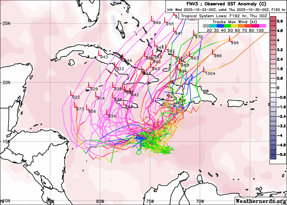
Notable left trend on FNV3 (Google DeepMind ensemble) from 12z run yesterday to today's 6z run - both in terms of the the members that show a sharp NE curve into Hispaniola being further west (Haiti vs. DR) and a lot more members turning west into the NW Caribbean
-
Major Hurricane Melissa - 892mb - 185mph Jamaica landfall
jconsor replied to GaWx's topic in Tropical Headquarters
With 98L's increased organization in the past 12 hours, the hurricane models finally seem to be getting a better handle on its track and intensification. https://x.com/yconsor/status/1980253973345923256 -
Major Hurricane Melissa - 892mb - 185mph Jamaica landfall
jconsor replied to GaWx's topic in Tropical Headquarters
AIFS seems off showing too much of a hole in the W Atl ridging N/NW of 98L. The other ML models don't support its scenario of 98L curving sharply NE toward Hispaniola. https://x.com/yconsor/status/1979887548240650357 -
Erin left a heck of a cold wake across the nw Atlantic, while the ENSO regions have cooled dramatically past two weeks. How will this influence Atlantic hurricane activity this month, and what are the two areas I am watching besides the E. Atl system? I go into depth on the large-scale factors for the next few weeks including Sep analogs, while looking at the "elephant in the room" that is being largely ignored IMHO because most tropical enthusiasts are focusing on the East Atlantic system. https://hurricanehacker.substack.com/p/the-times-they-are-changin
-
Please post the link for the vertical instability graphic. Thanks
-
ECMWF and Australian BOM models (amongst other seasonal models) suggesting a Central Atlantic NIno developing. This, along with portion of the very warm anomalies west of Europe gradually bleeding SW the Canary Islands and eastern tropical Atlantic, could help ramp up activity in the deep tropics, particularly west of 40W. https://x.com/yconsor/status/1930624747382964591
-
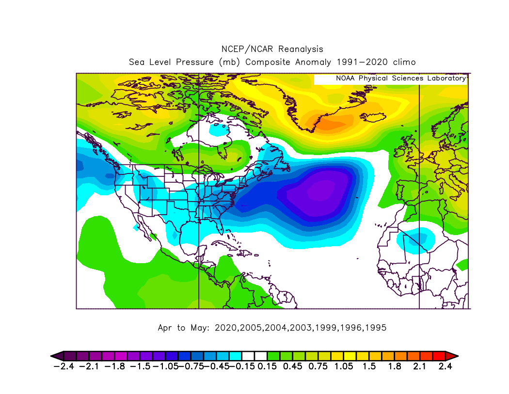
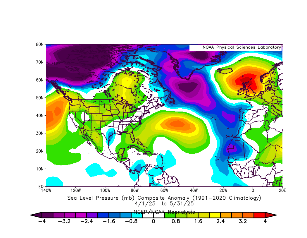
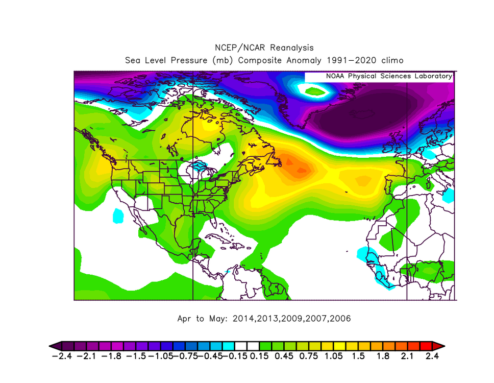
Hi Chuck, Interesting comparisons! I personally think using named storms to characterize active vs. inactive years is not particularly meaningful, given the human subjectivity and changes in NHC criteria over the years in terms of what is named. If we take the years with the most and least ACE since 1995, removing years that were El Ninos in the Apr-May timeframe (since they tend to be strongly correlated with -NAO), here are the most active years: 2020, 2005, 2004, 2003, 1999, 1996, 1995 The least active years: 2014, 2013, 2009, 2007, 2006 This year has some characteristics in common with the least active years (-MSLP anomaly from NW Territories of Canada to Greenland and +MSLP anomaly from the NW US to Hudson Bay and off the coast of the NE US). However, what is different from the inactive year composite, and closer to the active year composite, is the -MSLP from near Newfoundland to the central Atlantic near the Azores and then southward into the far east Atlantic and w. Africa. Additionally, the strong +NSLP from near the UK to Iceland is more similar to the active year composite. In short, a mixed bag, probably closer to inactive years but not a clear signal!


-
I was referring to highly unlikely possibility that so many of the hurricanes in both basins will become majors.
-
7 hurricanes and 5 majors in the Atlantic (and 6 and 5 in the East Pacific) is a rather comical outlook
-
In my view, it's mportant not to lump all La Ninas together. Modoki (central Pacific-based) La Ninas are notably different from traditional (East Pacific-based) Ninas. This has big implications for the level of Atlantic TC activity and where in the basin it tends to be focused. This year is more likely to end up a Modoki La Nina, with cooler water relative to normal focused in the central Pacific: https://x.com/yconsor/status/1927306239920283821
-
Thread explaining why I think chances for tropical development in the NW Caribbean and Gulf of Mexico ramp up significantly around Jun 4-10. https://x.com/yconsor/status/1926690131181731976
-
After not being much of a factor from 2019-24, looks like the N. Atlantic warm hole, a pool of relatively cooler water south of Greenland, is returning and should remain through peak hurricane season. This tends to ramp up the risk for E. Coast hurricanes, particularly slow-moving ones: https://x.com/yconsor/status/1925494559032668254
-
268Weather, an eastern Caribbean-based forecast service, has updated its hurricane season outlook: They are going for 21 TS, 9 hurricanes and 5 MH, with ACE expectation of 185. They indicate a 48% chance of ACE above 223 and a 52% chance of at least 11 hurricanes, each of which would place 2025 amongst the most active hurricane seasons on record. Seems odd that their baseline forecast for H is 9 and ACE is 185, yet there is around a 50% chance of ACE and hurricanes well above these numbers. If you look back at their track record, their May forecasts were considerably too high (bullish) in 2021 (ACE forecast 179), 2022 (175) and 2024 (218). On the other hand, their May 2017 forecast (ACE of 110) strongly underestimated activity. They were on the few seasonal forecasting agencies to catch onto slightly above normal activity (based on 1950-2020 normals) in 2018 and 2019. https://268weather.wordpress.com/2025/05/16/268weather-may-2025-update-atlantic-hurricane-season-still-projected-to-be-above-normal/
-
Levi Cowan (from Tropical Tidbits) raises significant skepticism about this report claiming AccuWeather forecasts were more accurate last year: https://x.com/TropicalTidbits/status/1925320719732547804
-
Detailed thread about recent trends in the Indian Ocean and ENSO regions, and indicators as to which seasonal models are more likely to have the right idea on ENSO situation during peak hurricane season: https://x.com/yconsor/status/1922643952135557481
-
Thanks for posting the S&P outlook, Barry. Very interesting! One of the few *data-driven* (not totally qualitative) landfall risk outlooks I have seen. Their maps seem to suggest higher than usual activity in the central Atlantic portion of the MDR (around 40-60W) and the Bahamas area (off FL coast) as well as the Caribbean and GOM.
-
Early indications from seasonal models favor an active Atlantic hurricane season, perhaps even hyperactive. https://x.com/yconsor/status/1901982720378425715
-
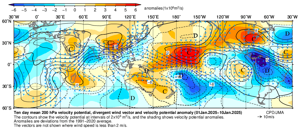
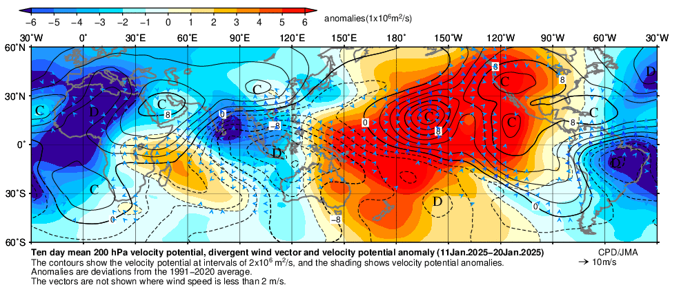
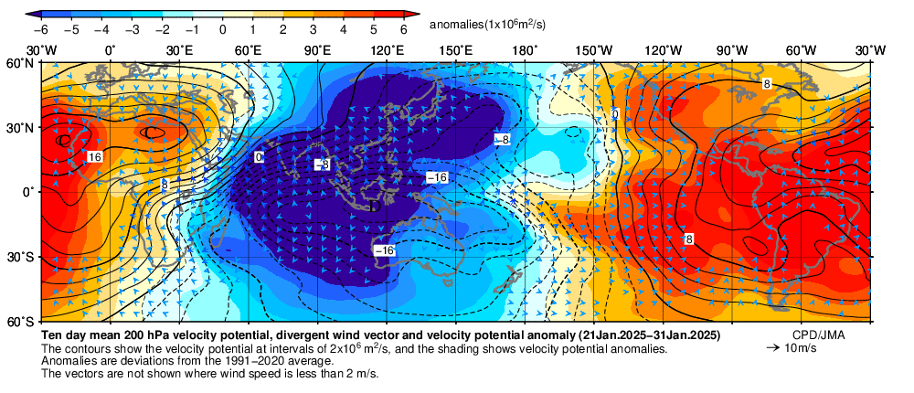
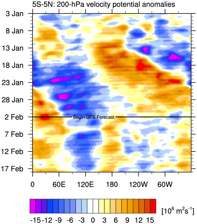
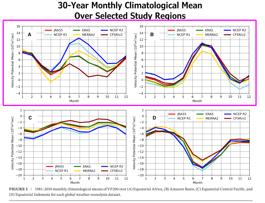
While I agree that extratropical (non-MJO) forcing played a significant role in the cold Jan 2025 outcome across the eastern/central US, we need to be careful using VP averaged across an entire month. Subseasonal variability clearly played a role here. In addition, the NCEP reanalysis has some notable biases in VP - it tends to show overly positive VP anomalies near C/S. America and Africa. See Stanfield et. al 2024, A Climatological Analysis of Upper-Level Velocity Potential Using Global Weather Reanalysis, 1959–2020: https://rmets.onlinelibrary.wiley.com/doi/full/10.1002/joc.8659 The vast majority of the cold anomalies in the eastern/central US occurred in the first two-thirds of Jan. From around Jan 23 onward it turned warmer than normal. The Jan 1-10 and Jan 11-20 VP anomalies show -VP anomalies migrating from the central/eastern Pacific and W. Atlantic, to the e. Atlantic and w. Africa. The magnitude is not as high as the negative anomalies that developed from the eastern IO to Maritime Continent in the Jan 21-31 period. However, especially in the Jan 11-20 period I would argue the MJO had a significant role, given the coherent wave of -VP (and corresponding +VP across the c/e. Pacific) that developed.
-
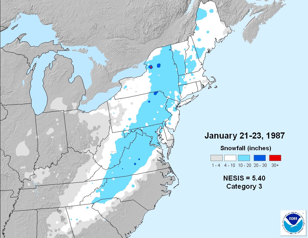
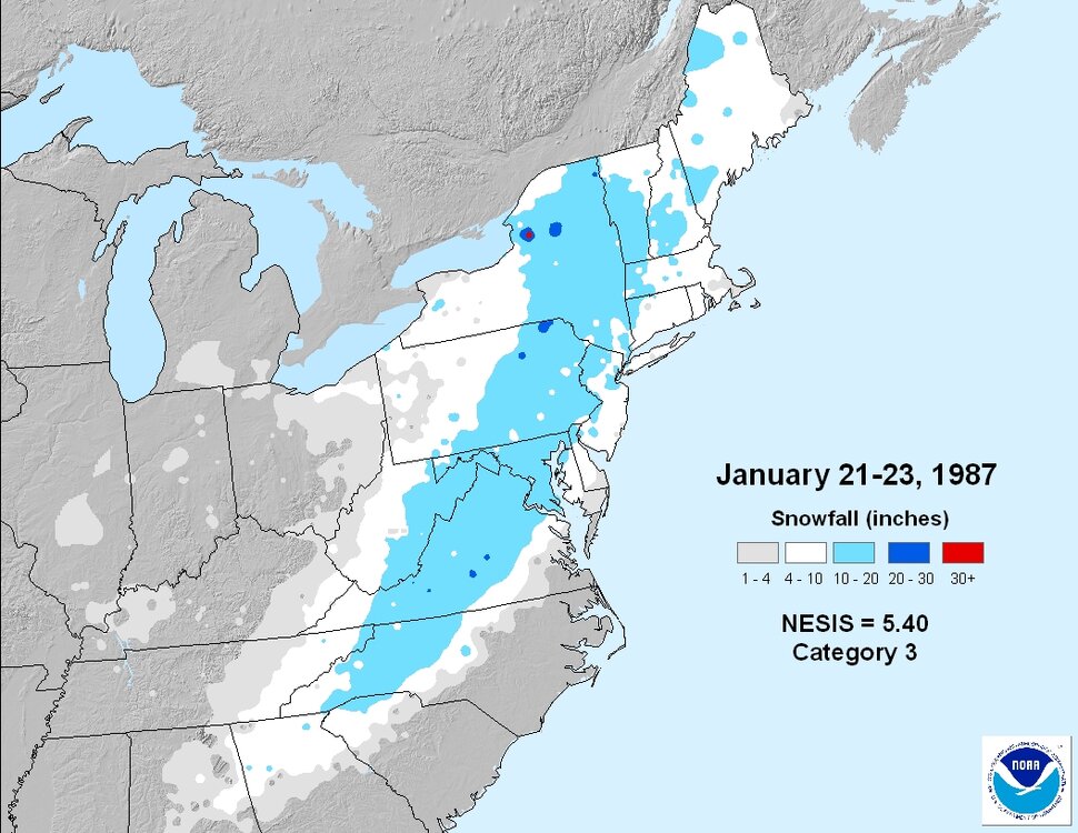
The Jan 22, 1987 snowstorm you are referring to is one of the main events that got me interested in weather. I grew up on the North Shore of LI (Roslyn) and I recall the forecast being for an inch or two, then quickly changing to rain. Instead snow piled up at 1-2" per hour and there was never a change to plain rain, just a little freezing drizzle at the end. As Ed said, it was traffic chaos. I was in second grade at the time and we were stuck at school for about 6 hours! The plows couldn't keep up with the snow and the hills on the roads in/around Roslyn made things even worse.
-
Some additional context to the unusual nature of this cold outbreak stratosphere-troposphere wise: https://bsky.app/profile/drahbutler.bsky.social/post/3lekmlyusmc25
-
Indeed, as we get closer in the guidance is correcting to a stronger high pressure and CAD wedge for the last week of Dec. https://x.com/yconsor/status/1870772344031268877
.gif.9da44c81a628481e8d1a3f702b8537e2.gif)