jconsor
-
Posts
1,016 -
Joined
-
Last visited
Content Type
Profiles
Blogs
Forums
American Weather
Media Demo
Store
Gallery
Everything posted by jconsor
-
2022 Atlantic Hurricane season
jconsor replied to StormchaserChuck!'s topic in Tropical Headquarters
-
Thread on severe inland flooding in central Florida in the Orlando-Kissimmee metro area. That area contains hundreds of small lakes, basically a sitting duck for flooding when heavy rains hit. However, this flooding is clearly historic! A thread of videos and photos of the inland flooding in central FL:
-
Ian's western eyewall appears to be nearly as strong as the eastern eyewall! Here are Andy and my explanations for why this may be the case. Hurricanes Michael and Delta saw a similar pattern.
-
Very interesting, @turtlehurricane! Do you have any published papers (either by yourself or others) that you can share on the topic you mentioned - frictional convergence near the coast feeding high vorticity into the eyewall and amplifying the vortex? Thanks. A quick Google scholar search yielded two papers from the 1990s, one on Hurricane Andrew and one on Irene which hit S FL in 1999: https://journals.ametsoc.org/view/journals/bams/77/3/1520-0477_1996_077_0543_haifdo_2_0_co_2.xml https://www.iweathernet.com/print/irene-1999.pdf (Easier to read version at https://www.iweathernet.com/tropical/hurricane-irene-1999-intensification-and-downbursts-after-landfall) Here is a more recent one I found: https://www.sciencedirect.com/science/article/pii/S2225603219300499
-
There are several analog hurricanes which hit SW FL from the S/SSW. The most similar ones are Charley and especially the infamous Oct 1944 Cuba-Florida hurricane. The Oct 1944 storm was similar in size to Ian and much larger than Charley, and hit as a category 3 with pressure of 949 mb. The similarity of the Oct 1944 hurricane to Ian is quite concerning for the insurance industry in FL, which is already reeling from the recent loss of numerous insurance providers. If the Oct 1944 'cane were to hit today it be expected to cause direct economic losses (damage) of around $80 billion - adjusting for per-capita wealth and population increases as well inflation! See the tweet below for methodology for calculating normalized losses from past hurricanes.
-
Great point here by Brian. Though Ian's intensity and track leading up to landfall is very similar to Charley, Ian is much larger than Charley! This will lead to a higher storm surge and much larger area impacted by destructive storm surge and winds.
-
2022 Atlantic Hurricane season
jconsor replied to StormchaserChuck!'s topic in Tropical Headquarters
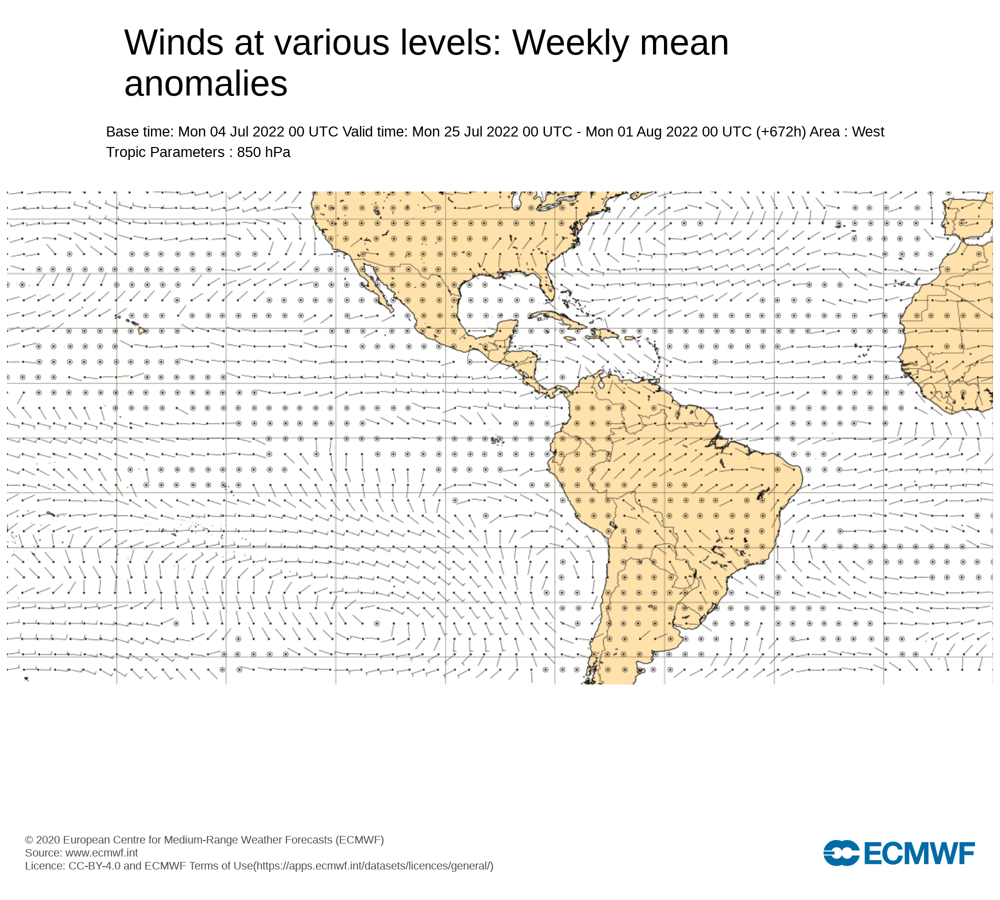
Update on the expected pressure pattern for Aug and resultant SST trends for the MDR. -
2022 Atlantic Hurricane season
jconsor replied to StormchaserChuck!'s topic in Tropical Headquarters
Counterpoint to some recent discussions about anomalously dry air in MDR persisting into mid-August. Looks to me like significant changes are afoot, with a moister MDR expected beginning in about 7-10 days. Given the improved upper level pattern/reduced shear as well as gradual moistening of the MDR, I would expect a TC to form in the MDR by the third week of Aug, perhaps a day or two earlier. -
2022 Atlantic Hurricane season
jconsor replied to StormchaserChuck!'s topic in Tropical Headquarters
Thread on SST evolution and analogs: -
2022 Atlantic Hurricane season
jconsor replied to StormchaserChuck!'s topic in Tropical Headquarters
Thread on two stronger than expected tropical waves in the eastern Atlantic. -
Thread on potential heavy rain event mid to late next week for portions of the mid-Atlantic and northeast. The heavy rain threat would exist in any case due to a slow-moving, deepening eastern US trough. However, the heavy rain risk could be amplified due to interaction between the trough and a slow-moving system forming near the central Gulf coast by Mon, which could be slingshotted NE and become a hybrid system.
-
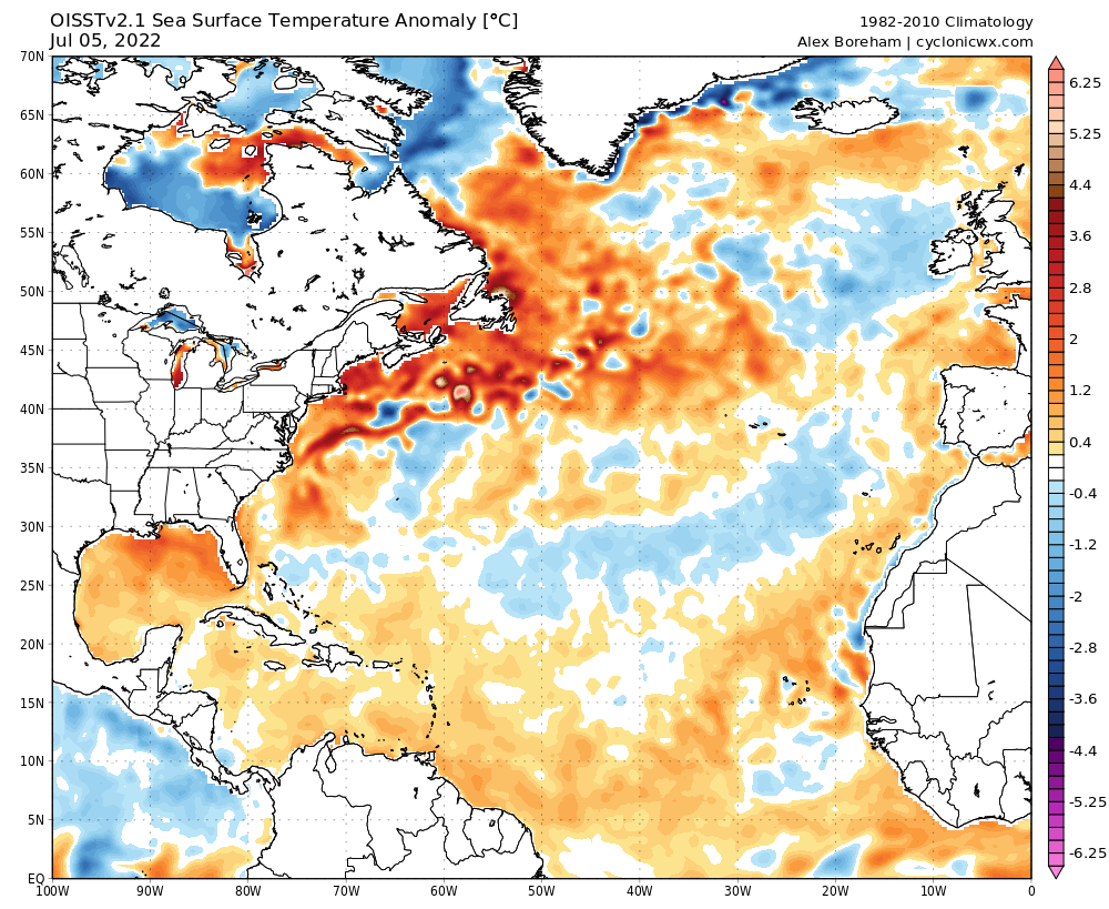
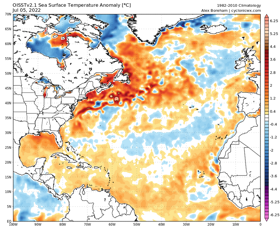
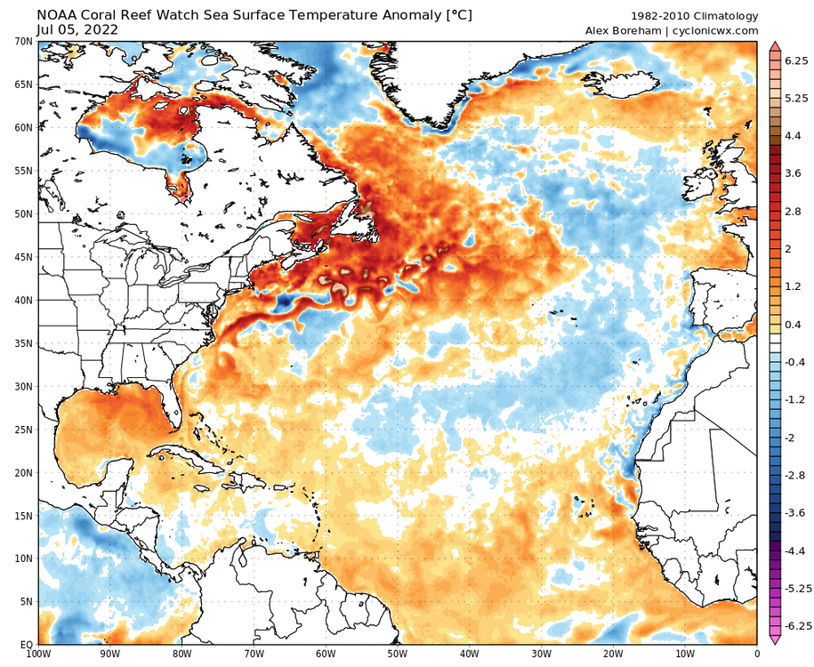
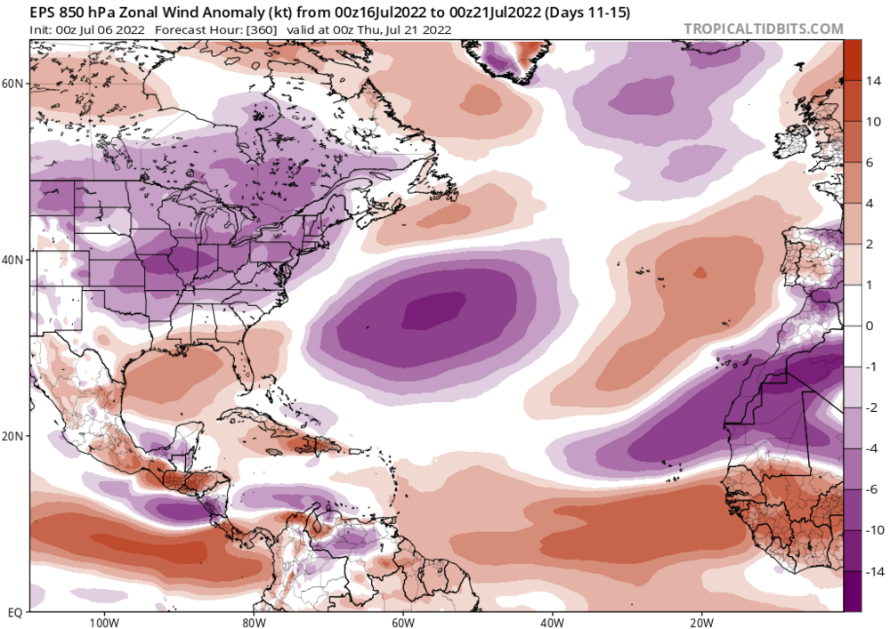
Be careful with CDAS. It is known to significantly underestimate Atlantic SSTs, especially in times of strong SAL. Also from experience I recommend being careful with NCEP/NCAR reanalysis-based SST. It runs much cooler than most other datasets. OISST and HADISST are better choices. Also keep in mind there was significant warming in the MDR in the last two weeks of Jun. After some brief cooling in the next week or so with a surge of stronger trade winds in the MDR, weaker than normal trade winds are expected to return second half of Jul into early Aug per long-range EPS and the weekly EPS. This would likely lead to further warming by the peak of hurricane season. This is consistent with stronger than usual West African Monsoon that has prevailed since 2015, contributing to reduced trades and helping to warm the MDR between Jun and Sep. I like the idea you came up with, of comparing this La Nina with the past 10. On the ESRL site, OISST and HADISST are not yet updated for Jun. When they update, I would be interested to see your plot would appear with those datasets.


-
2022 Atlantic Hurricane season
jconsor replied to StormchaserChuck!'s topic in Tropical Headquarters
Thread on the "missing" warmth in the eastern subtropical Atlantic (part of the +AMO tripole signature) and why it is expected to return in mid to late Jul. -
2022 Atlantic Hurricane season
jconsor replied to StormchaserChuck!'s topic in Tropical Headquarters
-
2022 Atlantic Hurricane season
jconsor replied to StormchaserChuck!'s topic in Tropical Headquarters
-
2022 Atlantic Hurricane season
jconsor replied to StormchaserChuck!'s topic in Tropical Headquarters
GFS has been better than the ECMWF in terms of showing the area of concentrated deep convection N. of Panama (and the convection in the SW Caribbean in general). It is still likely too quick to show development and intensification, but something in between the GFS/GEFS and ECMWF/EPS is possible IMHO. -
2022 Atlantic Hurricane season
jconsor replied to StormchaserChuck!'s topic in Tropical Headquarters
-
2022 Atlantic Hurricane season
jconsor replied to StormchaserChuck!'s topic in Tropical Headquarters
-
Here are some additional papers discussing the recent increases in NE US precipitation: Association between recent U.S. northeast precipitation trends and Greenland blocking https://www.researchgate.net/publication/358350986_Association_between_Recent_US_Northeast_Precipitation_Trends_and_Greenland_Blocking Since the early 2000s, the northeastern region of the United States (USNE) has received increased total annual precipitation along with more frequent extreme precipitation events. Although previous work has discussed the contribution to increased extreme precipitation from tropical cyclones, the large‐scale driver(s) of summer precipitation increases in the extra‐tropics has received little attention. Here, we show that the summer‐season rainfall surpluses across the USNE are related to the increased frequency of atmospheric blocking over Greenland and the negative phase of the North Atlantic Oscillation. The occurrence of these patterns in summer has been previously connected with southward shifted storm tracks and wet conditions across the eastern North Atlantic. Over the USNE, the circulation shifts are also related to enhanced rainfall due to southerly wind anomalies and increased moisture transport into and vertical motion over the region. It is important to note that the current generation of climate models used for future projections is unable to reproduce the observed tendency towards increased atmospheric blocking over Greenland. Thus, clarifying the association between Greenland blocking and recent precipitation changes across the USNE may help inform future climate projections of summer season rainfall for the region. Tropical Moisture Exports, Extreme Precipitation and Floods in Northeast US https://hess.copernicus.org/preprints/hess-2016-403/hess-2016-403.pdf A statistically and physically based framework is put forward that investigates the relationship between Tropical Moisture Exports (TME), and extreme Precipitation and floods in the Northeast United States (N.E. USA). TME correspond to the meridional transport of moist air masses, primarily born in tropical oceanic areas, to higher latitudes; contribute to the global climatology precipitation and its extremes; and are closely related to flood events, especially in the mid-latitudes. 15 The birth process and the steering of TME have seasonal and interannual variability. In this study, we explore how the TME are related to extreme precipitation and floods in the N.E. USA with a focus on seasonal variability and the potential impact of the El Niño Southern Oscillation. Links of TME to large floods events in N.E. USA in different seasons are first identified. The major moisture sources of the TME that contribute to precipitation extremes and floods in N.E. USA are then identified, together with 20 the seasonally and interannually varying characteristics in terms of both TME birth and entrance to the N.E. USA, and their subsequent contribution to extreme precipitation. We show that the extreme daily precipitation events are dominated by extreme TME entering the N.E. USA events in every season. Rise in Northeast US extreme precipitation caused by Atlantic variability and climate change https://www.sciencedirect.com/science/article/pii/S221209472100044X#bib7 Extreme precipitation (EP) in the Northeastern United States increased abruptly after 1996, coinciding with warming Atlantic sea surface temperatures (SSTs). We examine the importance of internal variability and external forcings (including anthropogenic and natural forcings) to these EP and SST increases by using the Community Earth System Model large ensembles and an optimal fingerprint method to isolate the effects of different forcings on 1929–2018 Northeast EP and North Atlantic SSTs. We find that external forcings have significantly influenced both Northeast EP and North Atlantic SSTs, with a time of detection in 2008 and 1968, respectively. Beyond SST changes attributable to internal variability of the Atlantic, anthropogenic aerosols and greenhouse gases are important drivers of SST changes, first detected in 1968 and 1983, respectively. Greenhouse gases are the only anthropogenic forcing exerting substantial influence on EP, first detected in 2008. We therefore attribute the 1996 EP shift to both unforced Atlantic variability and anthropogenic forcings.
-
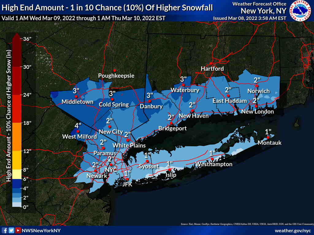
I understand Upton's reasoning (see their discussion here), that mixing with rain as well as sun angle/relatively warm surface temps will hold down accumulation. However, IMHO given that there is a fair amount of model guidance indicating moderate to heavy snowfall rates holding down sfc temps and allowing for heavier accumulation, it is irresponsible not to account for this potential in their high-end (90th percentile) snowfall forecast.

-
It typically takes several weeks to feel the effects of a sudden stratospheric warming event on our weather. But in the case of vortex stretching/reflection events like the one expected to take place later this week into early next week, the effects are typically felt within a few days.
-
Some important context on potential impacts of the brief, sharp stratospheric warming expected next week:
-
Trends toward colder last few days of Feb into early Mar have gotten stronger.
-
No Mar thread yet, so I am posting this here. Some encouraging signs for early to mid-March. Supported by MJO composites (note: I don't rely on MJO phase forecast charts, but instead use pattern recognition vs. MJO VP composites) and also analogs with strong SPV, +NAO, and La Nina.