-
Posts
4,734 -
Joined
-
Last visited
Content Type
Profiles
Blogs
Forums
American Weather
Media Demo
Store
Gallery
Everything posted by Windspeed
-
That doesn't seem unreasonable with this presentation... Things can change quickly for a TC when the mid-to-upper atmospheric environment cooperates. Idalia was still tilted and struggling a little over 24 hours ago.
-
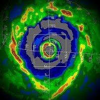
It's no doubt an organizing outer concentric band. But the eyewall is ripping right now. By far the best it has looked. Idalia has a lot of banding features spiraling into even the outer concentric band. It very well may lead to a full on ERC, but it may still strengthen quite a bit before that can starve the current eyewall. We may see this level off intensification prior to landfall, but it could still deepen quite significantly tonight before that leveling occurs. Will be interesting to watch.
-
We're also at nearly 15k ft beam from Tampa. The mesos are going to stand out more. We can't see the lower vort precip in the LLC of the eyewall. It may be circular given closer range.
-

2023 Atlantic Hurricane season
Windspeed replied to Stormchaserchuck1's topic in Tropical Headquarters
Aside from others, I'll eat some crow here. Granted, these two systems aren't from the MDR (which is still struggling due to the current pattern). Franklin formed out of a monsoon trough that collapsed. Idalia is the result of a CA surface trough. Either way, I gave up on the August window of activity. Not making excuses. We can have exceptions to the rule. Whether or not the MDR comes alive after Franklin and Idalia are gone will be the next course on the menu. It's still an El Niño year, but the Atlantic is now producing majors. Will it keep on keeping on remains to be seen. -
Franklin over here with its big fat eyewall getting ignored...
-
Mr. Hazelton...
-
Papin!
-
There has been a dryslot on the western semicircle of the core for much of the late afternoon. But the eastern semicircle looks more like a merger over the past hour. There exist some very intense wrapping cells at present.
-
It's clearly due to me posting that there isn't time for an ERC prior to landfall. Murphy's Law. The eyewall appears to be intensifying, perhaps a merger? Perhaps the outer banding is involved in the new impressive bursts. At any rate, the pressure is falling, not steady state or rising, so no clue.
-
There must be a hidden thread just for weenies.
-
The next 12 hours are going to be intense. We're getting into a more favorable upper environment from this point until landfall that should continue to improve. I do expect the eyewall to take off tonight. It may not have time to enter into an ERC before landfall now, either. So it may very well still be deepening at landfall. I do think this will reach lower end Cat 4 as it is coming ashore. I'd like to imagine there's just not enough time for it to reach any maximum potential given the environment.
-
Wow, the recent convective burst over the past hour is just nuts! It's one of the more explosive ones I can recall. Uncertain if perhaps a little terrain / frictional influenced. No surprise at the resulting pressure drop regardless.
-
I stuck that here in banter being more of a personal experience thing, but I admit a little worry about getting down there. It normally takes about 17-22 hour drive shared between the better half. We should realistically expect an absolute mess. This involves a family member in Key West situation, but I am seriously considering canceling the trip despite that. I've got serious concerns about trees down all over the roads for many days post event across N.FL and S.GA.
-
I am expected in Key West on Friday. Driving down from Tennessee. I have been in hurricane aftermath paths before, but the forecasted turn and angle is going to bring down a lot of old growth along the interstate routes and major highways in S.GA and N.Florida. Some of these areas haven't seen this inland forecasted intensity in a long time. Idalia should still be packing a formidable punch as it is moving back towards the Atlantic with trough enhancement. This will also be a big circulation. To the point, expect a lot of downed trees everywhere.
-
Ol' Phil busted out the historical perspective. At 29°N, this is the lowest central pressure measured in a TC since records have been kept consistently (1979).
-
Franklin is without a secondary wind maxima for now, and it may not have yet peaked. Category 5 is a possibility later on during another pass, depending on how long this recon flight will be out there. Incredible storm for this region of the Atlantic. Of course, given record SSTs east of the CONUS, this isn't all that surprising to see Franklin crank given the favorable upper environment. Additionally, it had a very hard life up until a few days ago....lol.
-
Gorgeous hurricane to track with what will hopefully be minimal impacts to Bermuda in a few days. A nice August ACE engine as well.
-
There is still mid-level shear imparting the circulation. That being said, the core is showing a favorable environment for continued bursts of deep convection. So it's going to be another 24 hours of give and take as bursts of convection try to wrap up shear east and then north of the center, then likely get blown back and fail to wrap from 700 to 400 hPa levels. I'd imagine this will occur repeatedly as the LLC drives just west of Cuba and into the SE GOM. Mid-level flow values won't become more favorable until well into tonight. That is when we may start seeing more alignment and more pronounced intensification on Tuesday. Eventually, into Wednesday, the flow vector will become more dangerous for significant intensification all the way into landfall, hence modeling and the official forecast.
-
HAFS A and B both suggested a slow evolution of the vortex with persistent runs with convection lopsided just to the east. Some runs even losing and redeveloping the LLC, though the most recent runs have not lost it. The main point is that neither have shown significant intensification until the TC is lifting NNE through the SE GOM into Tuesday. We'll just have to see if this plays out IRL. Also, data should be injected from reconnaissance flights today into the parent universal GFS to get an even better handle.
-
It's interesting that both 18z HAFS TC models lose the vorticity somewhat over the next 24 hours. It then comes back on both and rapidly reorganizes from 36-48 hours, and shortly afterward, lifts NNE as a hurricane. I don't know if this is simulated proximity to the Rivera Maya coast or some other atmospheric influence occurring. But it is odd at the breakdown, then rapid ramp up on that TC blend in such a short period of time.
-
Yeah, Cowan just noted the tighter core. It's a little anemic on the convective side at the moment, but it does still appear to be organizing. New convective bursts would aid that process. Additionally, convection that was focused east and south of Cuba is getting further away. This may also aid in easing any negative influences and subsidence working against the COC. That being said, it is drifting very close to the Rivera Maya coastline. If it remains offshore, the TC may ramp up on Sunday. If it meanders inland, obviously, that will delay the intensification process. Of course, that is very much what the Globals had been doing for quite a number of OP runs since yesterday.
-
First graphic for posterity...
-
I think this is a depression as well and probably will be classified this afternoon, if not certainly by 5PM. That radar imagery and the low-level cloud flow is too much to ignore. It looks like TCG literally occurred just prior or during that loop. Hopefully the NHC can get reconnaissance moved up to this evening. As for steering flow and what this is going to do the next 24-48 hrs. Does it drift west over the Yucatan or remain over the straits? Possibly meander into the SE GOM? Huge implications over the slightest movements now we clearly have a COC.
-
The only thing is perhaps land interaction as the ECMWF wants to shove the low inland. The GFS is also very close, meandering the low over or near to the Rivera Maya. They don't see TCG until Sunday into Monday, and it's 2-3 days before the steering flow lifts the TC northward. I think the modeling has to be taken seriously, but clearly they could be way off if TCG occurs today and the vortex remains over water.
-

2023 Atlantic Hurricane season
Windspeed replied to Stormchaserchuck1's topic in Tropical Headquarters
Sorry, bro. Better practice Idalia. Like a vidalia onion, only no "V"....


