-
Posts
4,734 -
Joined
-
Last visited
Content Type
Profiles
Blogs
Forums
American Weather
Media Demo
Store
Gallery
Everything posted by Windspeed
-
2023 Atlantic Hurricane season
Windspeed replied to Stormchaserchuck1's topic in Tropical Headquarters
The Aus BoM's new modeling output for El Niño 3.4 is bonkers. I mean, obviously hoping this is overdone, tropics aside. We'd be in uncharted territory here. -

2023 Atlantic Hurricane season
Windspeed replied to Stormchaserchuck1's topic in Tropical Headquarters
Perhaps the 2023 season will indeed be front-loaded for activity for the remainder of June, with a busy July and August before shear does eventually increase across the tropical and subtropical Atlantic by September as El Niño inevitably increases mid-to-upper level influence. An active June, July, and August thanks to significantly warmer MDR and most favorable AMO, but with declining activity during ASO. It would be a definite reversal of the last decade, but with the timing of a strengthening southwesterly jet and flow over the Caribbean coming into play much earlier than typical October/November. -

2023 Atlantic Hurricane season
Windspeed replied to Stormchaserchuck1's topic in Tropical Headquarters
The pattern might actually support a Carla Cradle TC in a week or so but please keep in mind that it's just fantasy at this point. The GFS likes to make somethings out of that region but it must be taken with a grain of salt. -

2023 Atlantic Hurricane season
Windspeed replied to Stormchaserchuck1's topic in Tropical Headquarters
The vague outlook numbers are very much indicative of too much uncertainty. The Atlantic is anomonously warm and AMO looks favorable, however, a moderate to strong El Niño counters that. If we have deep layer shear setup over the WATL by August/September, any window of heightened activity would likely be small. Yes, we may still get a few powerful hurricanes, but I would feel very uncomfortable making a forecast this year. I still think we're looking at a below normal season. If there is activity, it may either be front-loaded or focused on July/August. I think ASO will shut down with shear and a limited ITCZ by September. But again, a lot of unknowns. -
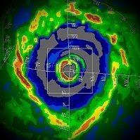
Pretty nasty TC. Hoping for some gradual weakening prior to landfall, but clearly, based on the recent MW trends above, it's not weakening at present. Looks like bad impacts for Myanmar.
-

2023 Atlantic Hurricane season
Windspeed replied to Stormchaserchuck1's topic in Tropical Headquarters
-

2023 Atlantic Hurricane season
Windspeed replied to Stormchaserchuck1's topic in Tropical Headquarters
-

2023 Atlantic Hurricane season
Windspeed replied to Stormchaserchuck1's topic in Tropical Headquarters
I think the idea here is that even if the BoM is overdone, a moderate to strong El Niño is looking ever more likely. But perhaps the possibility of a super Niño is on the table, which I wasn't even considering before. -

2023 Atlantic Hurricane season
Windspeed replied to Stormchaserchuck1's topic in Tropical Headquarters
The latest Australian BoM model just came out, predicting a super El Niño by August. This, taken with the current record high sea surface temperatures, is likely to drive record high global temps during the second half 2023. Interestingly, the Atlantic is still running high. If we get a pocket of favoribility over the Atlantic during August or September, we may still observe some decent Atlantic canes. But obviously, if we do so in fact experience a super El Niño, that window of activity should remain small. If systems get in the right place at the right time, SSTs should be favorable for an intense hurricane or two in the Atlantic. But I don't think the Atlantic hurricane season is going to be the main weather news unfolding if indeed a super El Niño unfolds. Global SSTs are far above mean even in comparison to the last 40 years. We could see some extreme regional weather events such as hyper drought and floods. At any rate, here we are.... -
Yikes...
-
10 hours into this crazy outbreak, three well-defined couplets are ongoing simultaneously in West Tennessee. Hope folks there took the watches and warnings seriously.
-
Evident debris ball after hit on Spencer, Indiana.
-
Couplet coming for (TMEM) Memphis INTL Airport's Radar tower.
-
Yes. This is the Tor warned cell WNW of Memphis.
-
-

2023 Atlantic Hurricane season
Windspeed replied to Stormchaserchuck1's topic in Tropical Headquarters
Right on cue... -
Nice video looking down upon the river and adjacent communities of Quelimane to give a small glimpse of the coastal geography there.
-
I'd imagine a pretty dire surge situation for low-lying coastal communities there. Non-stop onshore onslaught of flow and fetch in the southern semicircle of the cyclone must be driving water into the port and river estuaries around Quelimane.
-
Freddy is crawling into this latest landfall. Some modeling allows the cyclone to stall just inland only to re-emerge off the coast (again) with another period of reintensification. Need to go back over ACE numbers, but Freddy may have even surpassed Ioke for all-time highest now.
-

March 3 High Wind and Severe potential
Windspeed replied to Holston_River_Rambler's topic in Tennessee Valley
Yeah we did actually have some strong gusts associated with winds mixing down during the quasi-linear event. I am certain we had gusts around 50 mph. But I have to admit, the winds that came several hours after with partly cloudy skies were more impressive. No surprise that there were more outages that followed last night. Looks like counties up in Kentucky got it worse than Tennessee however.

