-
Posts
4,734 -
Joined
-
Last visited
Content Type
Profiles
Blogs
Forums
American Weather
Media Demo
Store
Gallery
Everything posted by Windspeed
-
2023 Atlantic Hurricane season
Windspeed replied to Stormchaserchuck1's topic in Tropical Headquarters
Look at what 24 hours can do to modeling. Nearly everything is trending down in intensity guidance for 94L. Shear and subsidence are being picked up, and the ensembles look much less enthusiastic about a well organized TC near or NE of the Lesser Antilles. We may still very well get a named TC threatening the Leewards, but less likely to be a formidable hurricane. -

2023 Atlantic Hurricane season
Windspeed replied to Stormchaserchuck1's topic in Tropical Headquarters
-

2023 Atlantic Hurricane season
Windspeed replied to Stormchaserchuck1's topic in Tropical Headquarters
Two camps diverge around day three. However, it is important to note that the GFS struggles with developement of 94L despite the potential favorable setup that may be in place. The ECMWF and CMC both like and pick up on development. Clearly, the EPS suites show multiple scenarios of a hurricane traversing the Lesser Antilles. The camps that split do so over differences in modeling of the mid-level steering flow between a stronger versus weaker ridge just north of the MDR. Also, whether the placement of a ULL being in a favorable position to ventilate versus impact on motion of the potential TC. If you split hairs, you get a strong TS near the NE Antilles. Obviously, a stronger ridge combined with a stronger hurricane gives us all the EPS members screaming major impacts from Barbados to Puerto Rico. It's still quite early, though. The GFS/GEFS camps could quickly swing towards the Euro and Canadian solutions in the coming days, or vice versa. OHC is plenty high in the western MDR for a strong hurricane. Just need to watch for atmospheric conditions and any potential mid-level shear. -

2023 Atlantic Hurricane season
Windspeed replied to Stormchaserchuck1's topic in Tropical Headquarters
GFS is back to CAG/WCARIB shenanigans. -

2023 Atlantic Hurricane season
Windspeed replied to Stormchaserchuck1's topic in Tropical Headquarters
Need to watch placement of the ridge. This might actually get driven into the E. Caribbean. -
Not so sure. Mid-level cloudfill in the eye at the timing of landfall may not matter. A product of shear, but might've been too late before induced weakening. The eyewall was pretty intense and intact. Just bad timing for landfall.
-
-
Interesting to note that the upper-level shear values over Lidia are very high based on satellite analysis. However, notice how there is a weak region of the mid-level shear pivoting with the circulation. Dead giveaway that Lidia's forward motion within the circulation is remaining stacked due to mid-level flow and low-level flow swinging ENE with the trough. It's put that same core in a region of intense divergence aloft; ventilation for high instability. Lucky for RI of the TC, unlucky for those at landfall point.
-
As expected, an impressive MW to boot.
-
-
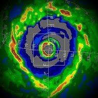
Impressive lightning currently around the eyewall. Pretty explosive intensification at the worst time. Lidia is a compact hurricane however. Should be a small region of hurricane force winds, though that will obviously be intense, especially with the abrupt rise in elevation for whoever or whatever is at that point inland.
-
Josh is on this one...
-
Philippe has dissipated.
-
Forecast looks a lot more confident since last night. Not really much to add. Bermuda may get some nastiness, but nothing they can't handle. Phasing with the low could impact Maine, however.
-
The low-level easterly steering flow in Philippe's locale isn't that strong. Due in part to Rina moving north in a pseudo-Fujiwara motion and also weakening ridge and trades. This has allowed for two critical developments. 1) Though mid-to-upper westerly flow has kept shear in place, the LLC has never been allowed to fully outrun and dissipate. Convection has built back repeatedly or just close enough to sustain the surface vorticity maximum. But the vortex has never aligned or stacked. So the weak low-level steering flow keeps the LLC moving west albeit slowly. 2) Time. The longer it takes for the TC to remain weak, the longer it will take to feel a deeper southerly flow and weakness in the ridge. This allows the downstream pattern to evolve longer, which ultimately can have consequences on eventual track. Essentially, shear vs steering flow isn't enough to kill Philippe, but is keeping it weak enough to let other steering features or synoptic players have more time to develop, which, in turn, could change the eventual track. I should also add that modeling has been poor. But that isn't surprising given the more chaotic nature of what evolved between the two TCs and steering currents. All of the above made the official NHC forecast take a right beating. It is hard to be critical about that given the nature of how the pattern and systems evolved.
-
TS Philippe, a storm I never thought had a chance to affect the Lesser Antilles, is doing that and more. Persistent convection is remaining nearly stationary in the SE quadrant of the cyclone as strong low-level convergence lifts rapidly, feeding into robust westerly mid-level flow. Significant flooding may occur into Wednesday for the islands with this setup. As for track, due to Philippe's motion WNW, the door is opening for a more W. Atlantic track. It should still turn north but may combine into a large ET cyclone that could even affect maritime Canada.
-
Philippe is now forecast to eventually turn into the N Central Atlantic and become a hurricane. Rina is forecast to continue weakening and remnant low to get absorbed. This is more or less following recent runs of the GFS.
-
Around 500nm between the two circulation centers.
-
Looks more like a broad surface trough now. Rina, OTOH, does have a vigorous surface vortex, though currently exposed. It's a fairly unimpressive mess at present for both systems.
-
Should also add that shear is really taking its toll on Philippe. I mentioned in the previous post the outcome of Rina becoming the dominant TC. That might actually unfold. The low-level circulation flow of Philippe looks very broad now on visible. Forget TS status. It might even open up tonight if degradation of the low-level circulation continues.
-
Too much chaos to simulate between the globals due to the close proximity of both Philippe and Rina's vort maximums. Additionally, we have a hybrid low (remnents of Ophelia) and an upper trough that will split off the ECONUS with uncertainty between 500 hPa ridging and weakness. I think it's a very low confidence forecast between either TC and their eventual tracks right now. If Philippe were more intense, I would consider Rina being absorbed or dissipating. But if Philippe drives SW due to the synoptic setup and Fujiwara effect, it should remain sheared just NE of the Leewards. Haven't said much since the initial post, as nothing much has changed in idea here. If Philippe can shake off Rina and lift north, it could find a more favorable environment and intensify. That was a potential outcome with the original recurve guidance, though that is now more uncertain. Likewise, if Philippe were to remain sheared, get decapitated, or outright dissipate, then Rina could possibly become the dominant TC and intensify. I don't really think anyone can accurately know the outcome of these systems at present. It's going to take a few days to watch unfold and iron out. Furthermore, modeling will continue to struggle with this setup and spit out some ridiculous solutions. Updating thread to cover both systems since they're so closely tied together right now. There is no need to make a separate TC thread for Rina.
-
Tropical Depression 17 has formed in the MDR of the Atlantic. It is not yet forecast by the NHC to become a hurricane. This is due to a future that includes westerly shear at the 20°N latitude stretching from just WNW of the TC to along the northern Leewards. There, however, is some uncertainty bearing on the location and timing of a WATL trough versus ridge strength west of the Azores. A fast turn north with a deepening upper trough to the west might eventually place the system in a more favorable environment in the N Central Atlantic. The TC should have a recurving track and sheared while doing so until late next week.
-

2023 Atlantic Hurricane season
Windspeed replied to Stormchaserchuck1's topic in Tropical Headquarters
Sorry, but if you can find anyone who can forecast 200+ ACE accurately, they need to be working for NOAA. Period. Total BS. -

2023 Atlantic Hurricane season
Windspeed replied to Stormchaserchuck1's topic in Tropical Headquarters
It's phenomenal for an El Niño year, and it's not a even a weak one. The warm Atlantic basin really did a number to offset +ENSO. Plus, the subtropical jet has been displaced as such to make shear just manageable enough to get MDR hurricanes. Though I would argue that shear has still been an issue, such as Franklin getting kicked hard early in its life cycle and Lee getting over-modeled as a long duration high-end hurricane. Still, there wasn't an analog for what we've been witnessing. Fortunately, the MDR 'canes have cooperated with a recurving pattern in place. Though, not to downplay future impacts by a weakening Lee on Maine and Canada. Also, we did get lucky with the timing of an ERC and landfall location by Idalia, though this was not an MDR system. With late Sept. and early Oct., we have the usual transition back to GOM and WCARIB systems, which could still pose a threat. Furthermore, it isn't too late to have an MDR system still be a land threat for the Lesser and Greater Antilles down the road as well. Having considered if a strong +ENSO will even shut down the Atlantic prior to normal seasonal ASO decline at this point. -
Wow.. Lee has had a massive expansion of hurricane force winds.


