

andyhb
-
Posts
20,454 -
Joined
-
Last visited
Content Type
Profiles
Blogs
Forums
American Weather
Media Demo
Store
Gallery
Everything posted by andyhb
-
The veering of the surface winds in behind the confluence axis in E MS does give me some pause about the early phase of the event. May take some time to respond to pressure falls associated with the deepening low.
-
Yeah that's a pretty decided shift on the NAM towards a more organized surface low and slower progression, and that has been taking place since last night.
-
There is definitely an EML here. Capping and the EML are two different things.
-
The other 12z CAMs (WRF variants) aren’t quite as high end as the HRRR, but they are certainly more active than the 3 km NAM. ARW and NSSL are probably outbreak scenarios taken verbatim.
-
Well, safe to say this could be a pretty big event. Convective evolution/mode concerns notwithstanding, there seems to be a consensus across all of guidance for hodographs supportive of long-lived supercells with long tracked tornadoes as early as 15-18z in LA/MS. The degree of low-level moisture is on the high side for this time of year, and I wonder if there may be some subsidence in the late morning following the passage of a potential lead shortwave that could help to suppress junk convection. Any discrete storm in the warm sector that manages to root in that boundary layer by early afternoon is likely going to be a problem. Now it's a question of what wrinkles the mesoscale throws in (and whether the NAM comes around more to the potent solutions suggested by the globals, particularly the UK and Euro).
-
And probably a strong/violent one.
-
See you in a few days.
- 825 replies
-
- 16
-

-

-
@wizard021 You don't need 1000 m2/s2 SRH to get a threat of significant tornadoes. Please stop with all of this nonsense.
-
Based on my experience being out there in SW OK as storms tried to develop, this was the case. Every attempt became a turkey tower, and part of it was likely due to all of the smoke in the warm sector limiting insolation (and the capping being stronger than the models had).
-
I was referring to the 12z runs here. The 18z was definitely less favorable, although there still seems to be some attempts at warm sector initiation.
-
A hodograph very similar in shape to this (but larger obviously) was in place near the storm that produced the Bassfield MS EF4 last year.
-
No one said you did. I'm just saying that I don't think the 12z CAMs were really a trend one way or another towards a really muted event ala 5/20/2019. If anything, the HRRR being a little more bearish than some of the WRFs might increase my confidence in a cleaner evolution, lol.
-
Main question in the SE usually is storm mode given lack of more obvious boundaries, but I'm not so sure that 12z CAM suite was as "grungey" as it would appear, especially a couple of the WRFs. The aggregate/average of them as depicted by the 12z HREF would likely be a significant severe event, with both supercells and bowing line segments. The big question is what does the storm mode look like post-21z when the low-level shear increases significantly. If there are still supercells ongoing by 00z and into the nocturnal period, watch out. The pseudo-cold core regime nearer to the upper low in AR/MO is also worth watching should it be able to destabilize sufficiently.
-
*Sees the discussion in this thread* *Rethinks life choices to visit it*
- 825 replies
-
- 19
-
-
-

-

Severe Weather Threat 3-16-21 through 3-18-21
andyhb replied to cheese007's topic in Central/Western States
Wednesday has the potential to be a widespread severe weather outbreak across the Lower MS Valley/Mid South/ TN Valley/even Lower OH Valley. An expansive EML and high BL moisture content yielding a wide region of destabilization, large area of favorable shear, and moderate forcing for ascent could yield multiple corridors of enhanced potential. Still some uncertainty surrounding the low level wind fields and northward extent, but the signals are rather troubling. -
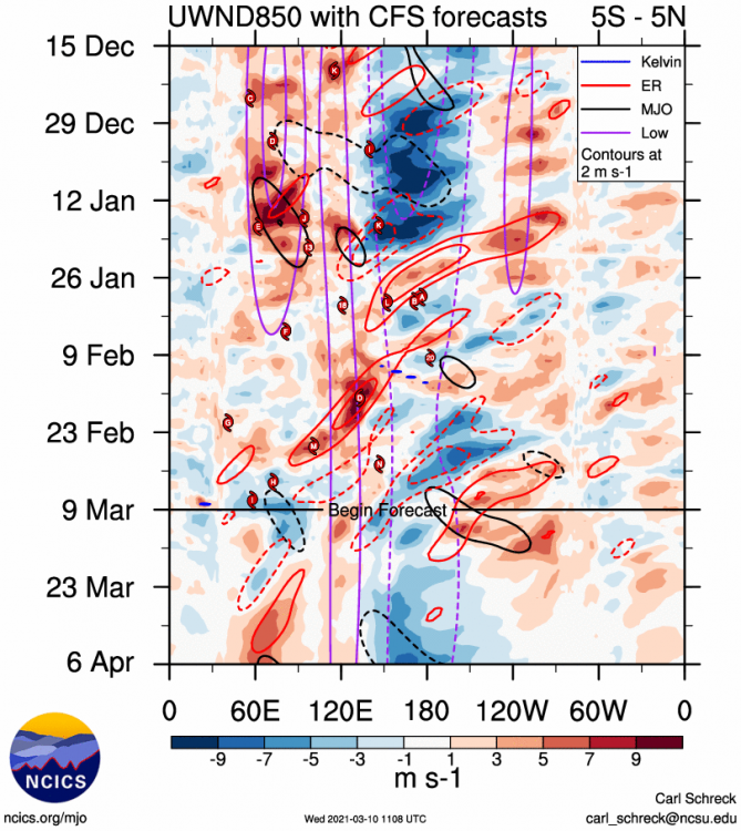
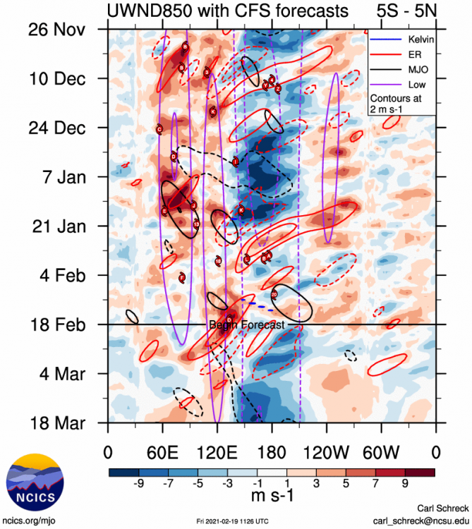
MJO related interference with the background state.
-
This. Ignoring what weather weenies like us want in favor of what is simpler for the public to understand is the whole purpose of working with social scientists. I don't see any need to trash this decision until we see actual results from the change.
-
I can't help but think the warming Pacific is influencing it.
-
Or we could just drop into split flow for the umpteenth time in the past decade and erase any chance for severe/a decent spring pattern, smh.
.thumb.gif.90c7bcc6c6498d26faf45e71e7e0ab2d.gif)
-
Secondary pulse in the strong trades near the dateline looks to becoming as the intraseasonal interference wanes going into March. Would expect some resurgence in the La Nina especially over the western ENSO regions.
-
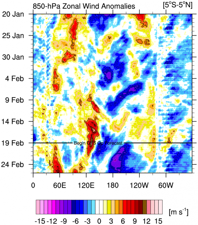
Look on the ensembles heading into March would suggest the potential for a warmer/wet period, with the possibility of severe wx somewhere, particularly east of the Plains. Again, this is tied to the retrograding longwave pattern across North America and the Eastern Pacific. Can be seen here in the 12z EPS mean, watch the behavior of the ridging that generally starts over the eastern Pacific, whose retrogression eventually leads to the jet dropping into the Pacific NW.
-
So uh... this pattern seems to be delivering, eh? (I say from Heart of the Arctic, Oklahoma)
-
You mean Joe Bastardi and Ryan Maue (original creator of the graphics) would seek all the attention they can get? Surely you can’t be serious! (I am serious, and don’t call me Shirley)
-
Been nice knowing you all, given what has a good chance of happening in OK over the next week or so...
-
Looking like the real deal folks. Setups like this with amplifying waves coming immediately in behind a PV lobe pushing a strong Arctic high into the Plains (and therefore not needing to worry about Ptype issues around here or even in TX) are exceedingly rare. The first storm next week is one thing (and obviously there is bust potential from dry slots/lack of moisture initially/exact track/suppression due to the Arctic air mass, etc.), but the real wild card is if it can be doubled up with the wave on its heels, which seems to be an increasingly possible scenario. Does remind me a bit of the cold snap and back to back storms in Feb 2011. Regardless, the answer to the question in the thread/topic description should be a resounding yes.


.gif.a5ca5dcd35f45448e9aeb23e4a3fe1bf.gif)

