andyhb
-
Posts
20,454 -
Joined
-
Last visited
Content Type
Profiles
Blogs
Forums
American Weather
Media Demo
Store
Gallery
Everything posted by andyhb
-
Strong tornado in progress SE of Calera AL rn.
-
I know, I just posted that for the receipts Also they apparently rated this EF2? Huh?
-
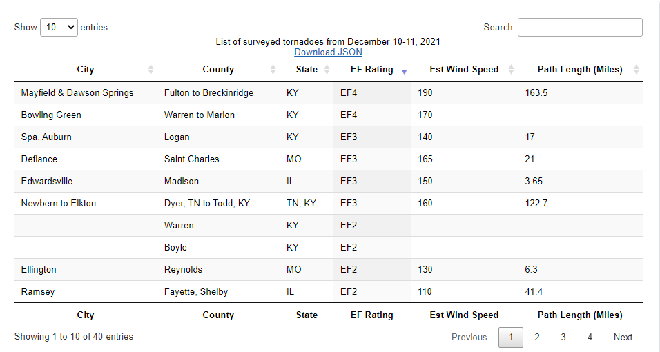
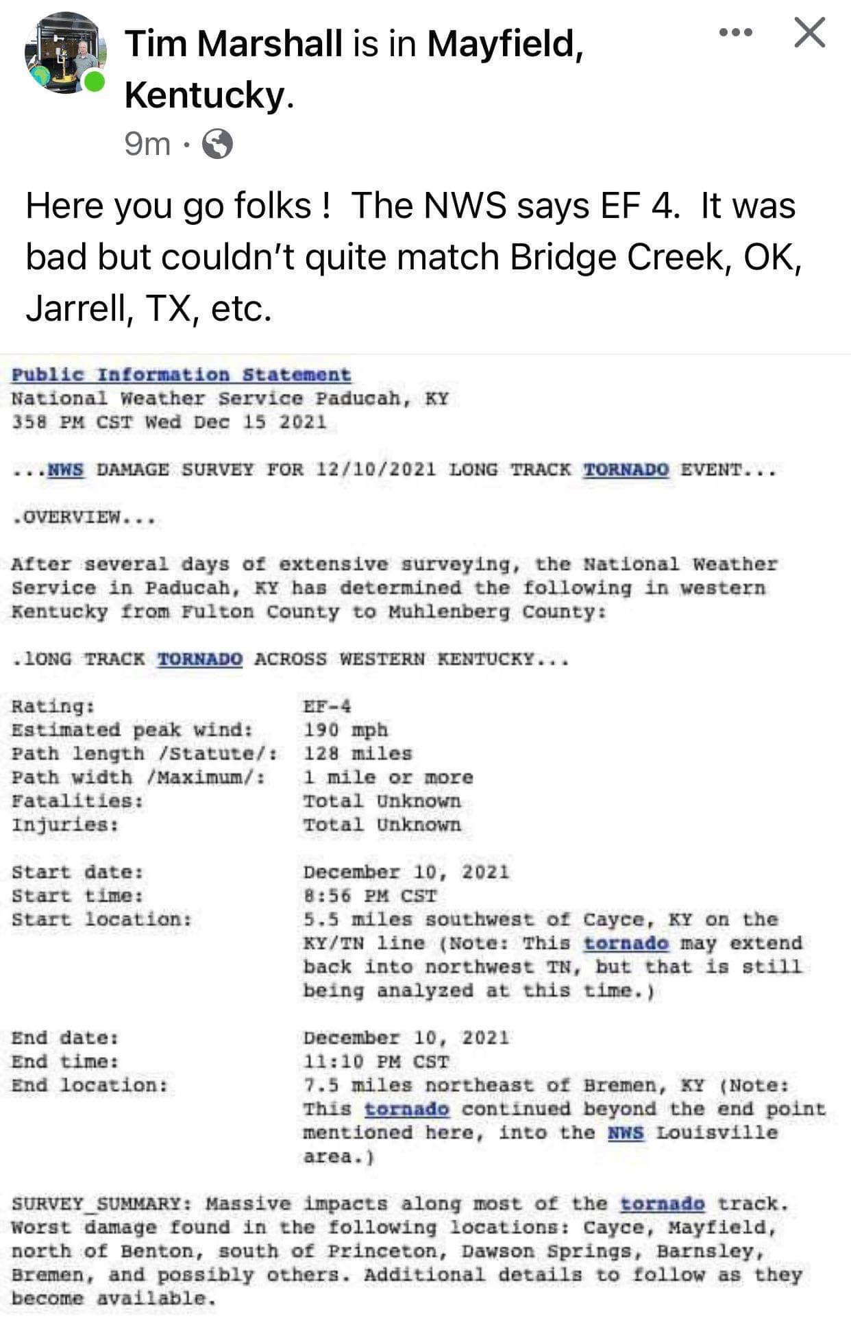
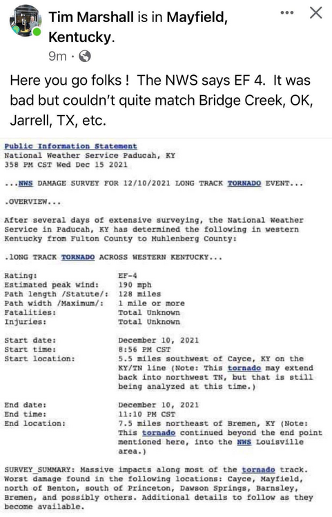
Bowling Green KY tornado has been upgraded to EF4 per NWS CRH.
-
Well, there it is. Also if we're expected Jarrell-level damage, I doubt EF5 is really achievable.
-
You know, for someone who is calling everyone else assholes, you're sure doing a lot of mud flinging yourself.
-
He didn't survey there.
-
Up to 15 fatalities now in the Bowling Green area.
-
They're probably better than in rural MS or AL, to be fair. Mayfield, Cambridge Springs, and the region of Princeton that was struck are reasonably well-off areas.
-
Some more higher end damage in this area of Warren County (near Bowling Green).
-
But why would you go through such an effort to tell everybody that "they've already seen this" when in reality this tornado is cut above many others?
-
This is a bunch of silliness, tbh. Most of us around here that have been for awhile have scrutinized all of the tornadoes you've mentioned here and more, and trust me when I say that there are comparisons between all of these going on. This one is bad, very bad. The damage with this across a very large area is just about unprecedented aside from tornadoes like Hackleburg, and there are many, many locations with houses that have been completely demolished or swept away. Enough to be compared pretty easily with tornadoes like the ones you've mentioned. The VROT/TDS signatures were up there with tornadoes like El Reno 2011, Vilonia, etc. I'm pretty sure most are aware of the DIs and their limitations, otherwise there wouldn't be this much discussion. As far as December tornadoes go, this one is unprecedented, and this is coming from someone who has been watching these things for over 20 years now. There is really no need for a condescending essay like this.
- 939 replies
-
- 15
-

-
Uhhh, yikes.
-
Devastation in the Cambridge Springs area on the western shore of Kentucky Lake.
-
Large industrial buildings flattened or even swept away in Dawson Springs KY. The list just goes on and on and on.
-
$800,000 house reduced to a slab in Bremen KY.
-
I highly doubt it will come close to challenging the Tri-State tornado, as bad at is. I'm wondering if he's talking more about recent history, which would be Joplin (158 deaths). Which would still be horrific. Right now the official toll from the tornado is at least 36 (20+ in Mayfield, 4 in the Princeton area, and 12 in Muhlenberg County including Bremen).
-
Definitely will be some severe weather with that thing on Wednesday. Too much anomalous warmth/moisture + a very powerful trough for there not to be.
-
I think we're going to have multiple violent tornadoes out of this. I've seen probably 5-6 candidates.
-
Coverage from WPSD-6 in Paducah of the Mayfield tornado.
-
https://www.facebook.com/stevecampbell23/videos/620717605842904 This right here is one of the most complete wipeouts I've ever seen after a tornado. Bremen, KY. High end EF4/EF5 material.
-
This is ridiculously intense damage near Earlington KY.
-
Possibly double digit fatalities in Bremen from the Mayfield tornado. That is a tiny town.
-
More devastation from the area around Earlington KY.