andyhb
-
Posts
20,454 -
Joined
-
Last visited
Content Type
Profiles
Blogs
Forums
American Weather
Media Demo
Store
Gallery
Everything posted by andyhb
-

Severe Weather 3-23-23 through 3-26-23
andyhb replied to cheese007's topic in Central/Western States
Looking over this for the past few days, Friday could be a very nasty day basically from the Sabine Valley across the Lower MS Valley towards the Tennessee Valley. The 500 mb setup on the GFS/Euro/etc. favors a significant severe event, and a few of the models are starting to catch on to greater destabilization than indicated earlier, and some of this could be nocturnal. 30% hatched on the D3 currently and I think there's a good chance we see at least a moderate risk by D2/D1. -
Spring 2023 Medium/Long Range Discussion
andyhb replied to Chicago Storm's topic in Lakes/Ohio Valley
Lol, now the ensembles back away from the more amplified 3/26 idea. Naturally. Initial troughing isn't amplified enough in the west and there's too much vorticity leaking eastward early + the PV lobe near Hudson Bay is creating confluence that shears the trough out with eastward extent. Looks like it's 3/24 or bust right now. -
Spring 2023 Medium/Long Range Discussion
andyhb replied to Chicago Storm's topic in Lakes/Ohio Valley
Going to mention this here to start, but while the shorter-term attention is on the trough coming through around 3/23-24 for appreciable severe potential, something bigger may be lurking right in behind if the following system amplifies more in the west. This has been a trend in the ensemble guidance for the last several runs. The lead system never really makes much of a dent in the Gulf as far as frontal intrusions go. What's left behind is a very moist air mass waiting to be pulled north. The 500 mb setup around 3/26-27 on all of the 12z models except the GFS (lol) would indicate the possibility of a rather large scale severe weather event should a couple of tweaks occur. It probably does need to amplify a bit more to get an earlier low-level response for pulling moisture north, but the signal is generally for a broad-based trough with a very intense jet max and strong flow overspreading a large area. All will depend on track/initial amplification and the timing/magnitude of the low-level response and surface cyclogenesis. Below is the run-to-run 500 mb mean shift in the last few runs of the EPS. Can see how it's shifting slower (more wave spacing) and deeper, both of which would allow for more modification following the 3/23-24 system.
-
Huh? Instability is one the strengths with this setup especially closer to the Red River unless you're only looking at the GFS. A lot of CAPE concentrated in the lowest 6 km, which should yield some strong updrafts assuming initiation does take place.
-
Feel like there should be a severe weather thread for this sub-forum for this event too. OV into TN looks potentially nasty tomorrow.
-
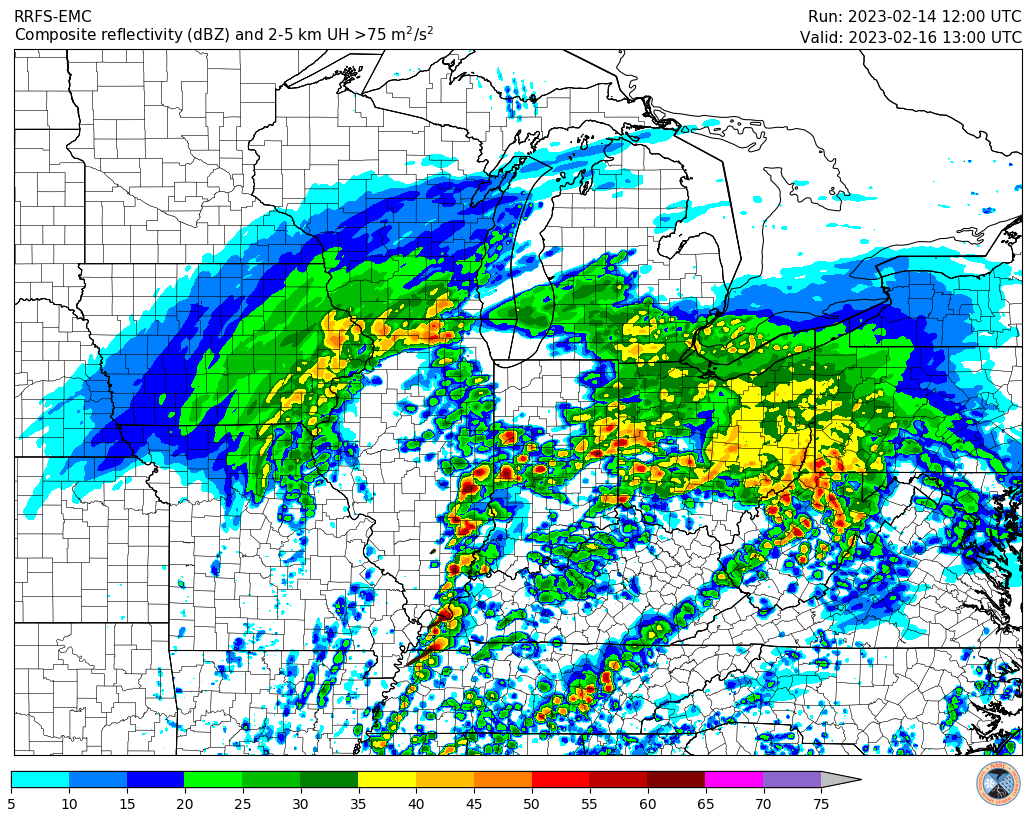
2023 Short/Medium Range Severe Weather Discussion
andyhb replied to Chicago Storm's topic in Lakes/Ohio Valley
Leap Day 2012 is a notable exception. -
2023 Short/Medium Range Severe Weather Discussion
andyhb replied to Chicago Storm's topic in Lakes/Ohio Valley
New RRFS looks pretty interesting.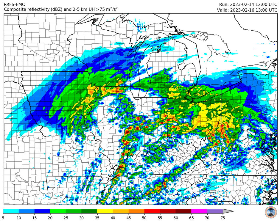
-
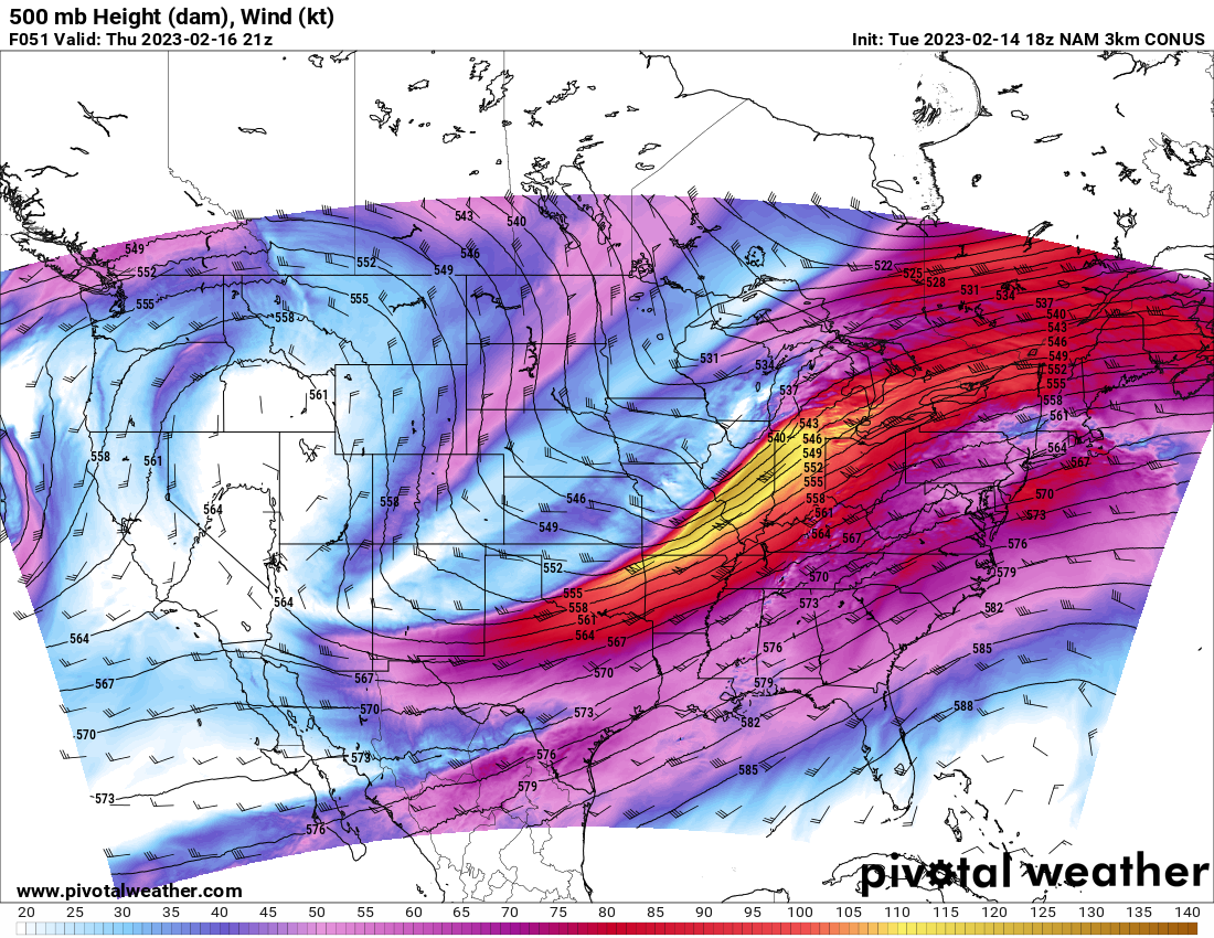
2023 Short/Medium Range Severe Weather Discussion
andyhb replied to Chicago Storm's topic in Lakes/Ohio Valley
Ohio Valley may be rather interesting on Thursday just looking at the setup aloft, and especially if the surface winds can stay closer to southerly. This type of setup has yielded some bigger events in the region in the past.
-
Historic Christmas Lake Effect Blizzard
andyhb replied to BuffaloWeather's topic in Upstate New York/Pennsylvania
Approaching the death toll of the ‘77 storm in the area. -
Historic Christmas Lake Effect Blizzard
andyhb replied to BuffaloWeather's topic in Upstate New York/Pennsylvania
How tf was it not issued earlier and why weren't all businesses closed? It was apparent this would be bad for days. -
Historic Christmas Lake Effect Blizzard
andyhb replied to BuffaloWeather's topic in Upstate New York/Pennsylvania
Scanner traffic around Buffalo has not been good, cars getting trapped in massive drifts and people potentially succumbing inside, particularly to carbon monoxide from blocked tailpipes. It literally does sound like a repeat of 1977. -
Historic Christmas Lake Effect Blizzard
andyhb replied to BuffaloWeather's topic in Upstate New York/Pennsylvania
Yeah this is phenomenal. -
Historic Christmas Lake Effect Blizzard
andyhb replied to BuffaloWeather's topic in Upstate New York/Pennsylvania
That is absolutely unreal. -
Historic Christmas Lake Effect Blizzard
andyhb replied to BuffaloWeather's topic in Upstate New York/Pennsylvania
They’ve had numerous 0 or 1/16th mile visibility reports over the past couple hours, I’m not so sure that’s sensor failure. -
Historic Christmas Lake Effect Blizzard
andyhb replied to BuffaloWeather's topic in Upstate New York/Pennsylvania
I mean by definition, it would be extremely rare to have two historic LES events over the course of just over a month. -
Pre-Christmas (Dec 21-23rd) Winter Storm Part 2
andyhb replied to Chicago Storm's topic in Lakes/Ohio Valley
I'm still a bit suspicious of how far north the 00z NAM is with the primary surface low during its main development though given the location of the strongest upper level diffluence presented in the model (and also in the 18z Euro, which was the more impressive solution). Such a difference could make or a break a major storm for many areas, particularly in Michigan/NW OH/N IN. -
Pre-Christmas (Dec 21-23rd) Winter Storm
andyhb replied to Chicago Storm's topic in Lakes/Ohio Valley
Conditions on Lake Erie and Ontario late Friday into Saturday are going to be absolutely nuts. -
Upstate/Eastern New York-Into Winter!
andyhb replied to BuffaloWeather's topic in Upstate New York/Pennsylvania
Probably should have a separate thread for this thing here. -
Pre-Christmas (Dec 21-23rd) Winter Storm
andyhb replied to Chicago Storm's topic in Lakes/Ohio Valley
Matures too late on the Euro. -
Pre-Christmas (Dec 21-23rd) Winter Storm
andyhb replied to Chicago Storm's topic in Lakes/Ohio Valley
GFS way west. Gonna be another cutter before long lol. -
Pre-Christmas (Dec 21-23rd) Winter Storm
andyhb replied to Chicago Storm's topic in Lakes/Ohio Valley
Could actually see severe blizzard conditions verify over a pretty large area if this thing is as intense as it could be. This one checks off all the boxes as of now. “A severe blizzard has winds over 72 km/h (45 mph), near zero visibility, and temperatures of −12 °C (10 °F) or lower.“ -
Historic Lake Effect Event?! 11/17-11/21
andyhb replied to BuffaloWeather's topic in Upstate New York/Pennsylvania
This dude is kind of an idiot tbh, not a great source for vetting. -
Historic Lake Effect Event?! 11/17-11/21
andyhb replied to BuffaloWeather's topic in Upstate New York/Pennsylvania
A fitting finale for this historic event. Additional low level convergence near/along the cold front is probably enhancing this thing quite a bit. Would have to think that this will kick several places over 80" for the event and many over 70". -
Historic Lake Effect Event?! 11/17-11/21
andyhb replied to BuffaloWeather's topic in Upstate New York/Pennsylvania
That’s the national versus the state record. -
Historic Lake Effect Event?! 11/17-11/21
andyhb replied to BuffaloWeather's topic in Upstate New York/Pennsylvania
This might be the best photo I've seen yet of the "white wall".