andyhb
-
Posts
20,454 -
Joined
-
Last visited
Content Type
Profiles
Blogs
Forums
American Weather
Media Demo
Store
Gallery
Everything posted by andyhb
-
To be fair, he also has raised a lot of money for the community. You can't fault him for that.
-
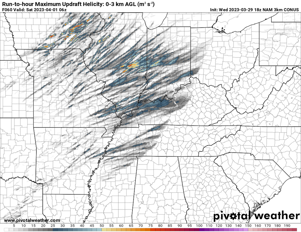
Come on, seriously now. You just don't see output like that from the 3 km NAM.
-
HRRR solutions later are likely going to be pretty nuts if the 3 km NAM is already this aggressive across the warm sector (with supercellular storm modes).
-
Early 3 km NAM runs certainly don't do anything to suppress this potential. Impressive parameter space across the entire warm sector.
-

Spring 2023 Medium/Long Range Discussion
andyhb replied to Chicago Storm's topic in Lakes/Ohio Valley
Think we're going to need a specific thread for 4/4 given the potential magnitude of Tuesday's threat, but we have a large D7 15% area outlined in the latest D4-8.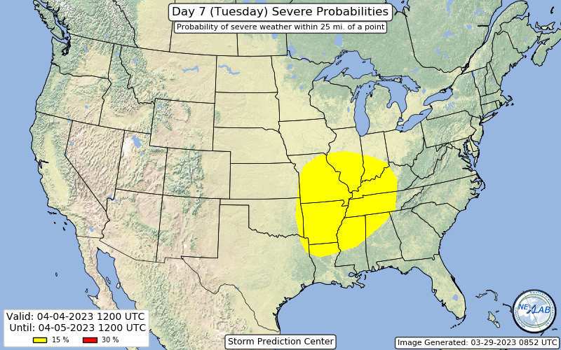
-
Huge D3 enhanced/30 hatched area issued.
-
Spring 2023 Medium/Long Range Discussion
andyhb replied to Chicago Storm's topic in Lakes/Ohio Valley
Somehow the 00z Euro came in and outdid last night's 00z run in terms of insanity. A 971 mb low with plenty of moisture access. Absolute bomb. Will just report my tweet here for the ensemble means, which all indicate that Tuesday could be a big day. -
Probably because it's almost -20 degrees at 500 mb and below freezing at 700 mb yielding extreme 0-3 km CAPE and low-level lapse rates.
-
Spring 2023 Medium/Long Range Discussion
andyhb replied to Chicago Storm's topic in Lakes/Ohio Valley
12z GFS/GEFS is also incredible in the Tuesday-Wednesday window next week. -
Spring 2023 Medium/Long Range Discussion
andyhb replied to Chicago Storm's topic in Lakes/Ohio Valley
00z Euro for 4/4, holy mother of god... -
You could take a... "detour" to Eastern AR perhaps.
-
500 mb presentation on the Euro is a classic for a significant severe event in the Midwest.
-
CSU MLP is going off for Friday with a massive 45% hatched area.
-
2023 Short/Medium Range Severe Weather Discussion
andyhb replied to Chicago Storm's topic in Lakes/Ohio Valley
That’s a very large 30% in the D5. -
Severe Weather 3-23-23 through 3-26-23
andyhb replied to cheese007's topic in Central/Western States
Strong tornado ongoing WNW of Tuskegee AL. -
2023 Short/Medium Range Severe Weather Discussion
andyhb replied to Chicago Storm's topic in Lakes/Ohio Valley
00z models look nasty for Friday in portions of the sub-forum. A couple of them have what would probably be a significant severe weather outbreak from the Mid MS Valley to the western Lakes. Some very high end solutions here in the GEFS. -
Severe Weather 3-23-23 through 3-26-23
andyhb replied to cheese007's topic in Central/Western States
And now up to 21...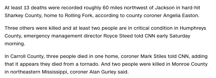
-
Severe Weather 3-23-23 through 3-26-23
andyhb replied to cheese007's topic in Central/Western States
Report from another forum of the situation in Amory MS. Death toll looks to be up to at least 14.
-
Severe Weather 3-23-23 through 3-26-23
andyhb replied to cheese007's topic in Central/Western States
7 dead per county coroner in Sharkey Co. MS (Rolling Fork area). -
Severe Weather 3-23-23 through 3-26-23
andyhb replied to cheese007's topic in Central/Western States
That was a devastating hit on the northern portion of Amory. -
Severe Weather 3-23-23 through 3-26-23
andyhb replied to cheese007's topic in Central/Western States
Absolutely violent tornado heading for Amory, and that is not a small town. -
Severe Weather 3-23-23 through 3-26-23
andyhb replied to cheese007's topic in Central/Western States
Debris above 30k feet with this thing, very likely violent. -
Severe Weather 3-23-23 through 3-26-23
andyhb replied to cheese007's topic in Central/Western States
Large wedge tornado in progress near Rolling Fork, MS. -
Severe Weather 3-23-23 through 3-26-23
andyhb replied to cheese007's topic in Central/Western States
06z HRRR, holy mother of god… -
Severe Weather 3-23-23 through 3-26-23
andyhb replied to cheese007's topic in Central/Western States
SPC outlook makes it seem like they were quite close to a high risk, but the disagreement from the CAMs held them off.