andyhb
-
Posts
20,454 -
Joined
-
Last visited
Content Type
Profiles
Blogs
Forums
American Weather
Media Demo
Store
Gallery
Everything posted by andyhb
-
Curious to see the exact periods of projected tornado events there. I have some disagreements with doing that, namely all of the things that could go wrong that can't be forecasted on the sub-seasonal/seasonal timescale. Are these periods just when "western trough/eastern ridge" is expected?
-
Lol, all the climate models are like "what severe weather season". NMME, CANSIPS, Euro, you name it. Poleward retracted jet + torching southwest/south-central US + dry.
-
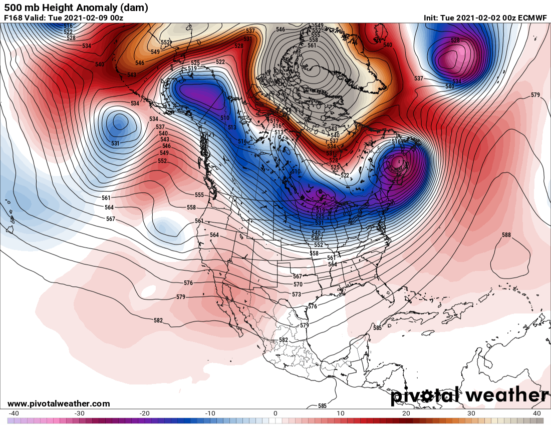
A storm like the one towards the end of the 12z Euro would have almost unlimited potential with that Arctic air mass in the cold sector. That would be a rare combination of that plus a wide open Gulf. Shows the potential here if we can get a wave to properly amplify.
-
Not going to see many crazier -NAO blocks than this on the 00z Euro at 168.

-
Wants to torch the southwest/south-central States for spring too, not ideal for severe weather potential. I do wonder if it's killing the Nina in the western zones too quickly though.
-
 Things you probably want to see if you're wanting a big hit out of this thing in this sub-forum.
- 2,426 replies
-
- 2
-

-

-
- heavy snow
- ice pellets
- (and 3 more)
-
Track notwithstanding, powerful trough/jet streak + good moisture transport + cold air dumping in behind = potential for a blockbuster storm should the trough ejection go properly here (00z UK is an example of how that can be screwed up). 00z parallel GFS was dumping some stupid numbers over NE and IA. Edit: 00z Euro also an example of how the ejection can get screwed up.
-
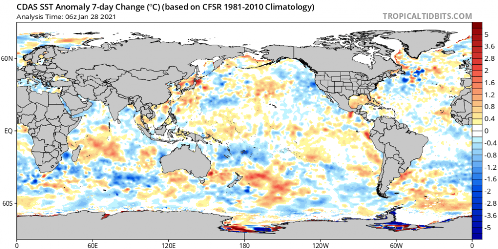
-PDO signature getting stronger over the last week per CDAS (cooling along the West Coast + warming over the north-central Pacific), as is the +TNI over the ENSO regions (Nino 4 substantially cooler than Nino 1.2).
-
Lol @ McHenrySnow reacting with a weenie emoji to this. You're not acting like a degreed meteorologist, man.
-
That trough/pattern in late March/April for lack of a better term... yikes.
-
Tennessee Valley and Southern Appalachians.
-
January Storm Term Threat Discussions (Day 3 - Day 7)
andyhb replied to WxUSAF's topic in Mid Atlantic
Some absolute monsters on that 12z EPS.
-
Not a single mention of the destructive, likely significant tornado in the northern suburbs of Birmingham (Fultondale/Center Point) tonight?
-
Also can a moderator change the title of this thread, considering it is certainly no longer 2019?
-
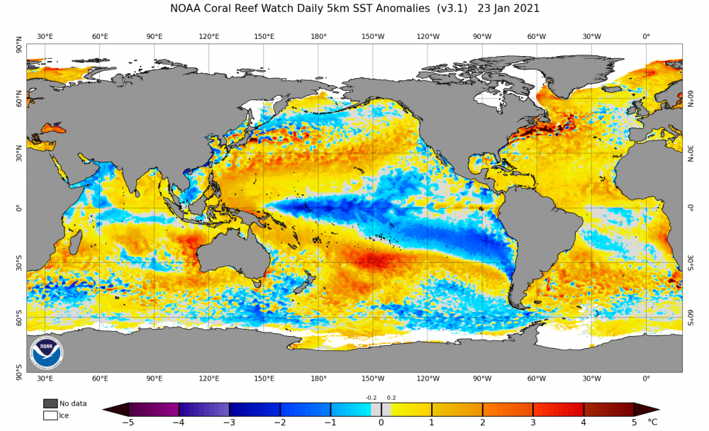
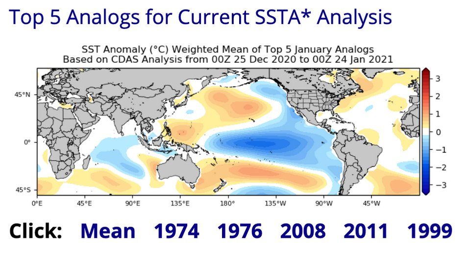
Did some skimming of SSTA data tonight and I'm intrigued by that warm pool centered at ~150˚W and 30˚S to the south of the cold SSTAs with the Nina. Based on looking into some previous analogs around this time, it seems like that strong meridional dipole is not present in years such as 2006, 2009, 2012, 2017, and 2018 (generally quieter severe seasons especially late season). It is more prevalent in several big Nina springs though, including 1974, 1976, and 2011. It's probably to some degree why this CDAS-derived SSTA analog product from Tropical Tidbits is essentially grouping a who's who of Nina springs with a lot of tornadoes/severe weather, including some with very large outbreaks. You can see the SSTA dipole present in the Southern Hemisphere in the mean here.
-
This quote from TSSN12's sig via baro from GHD I.
-
Can you both take your crap to DMs?
-
Yes. This is exactly it. The confluence between the TPV dipping southeastward into Ontario and the SE ridge downstream.
-
The reason for lower totals further east is because of the shearing of the parent shortwave and resultant partial loss of dynamic support with time. This has nothing to do with temperatures.
-
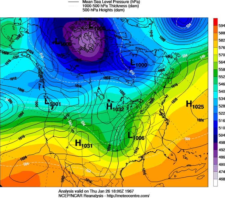
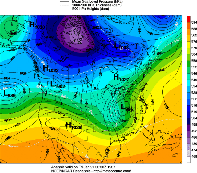
The January 67 blizzard was not a phaser. It was one shortwave (more amplified than this one, but it was not a Jan 1978 type scenario).
-
No, it isn't. Stop clogging up the thread. This system has never been a "phaser" and it doesn't need to be for foot plus totals. The reasons why have been discussed ad nauseam over the past few days, but you continue with this borderline trolling nonsense.
-
2015? Sure. 2011? Not a chance in hell.
-
This. That would mean there's barely a shortwave left due to confluence from the ULL/TPV and the SE ridge, there would barely be a "brunt".
-
I don't really see how one can establish a "trend" when models keep flip-flopping back and forth, nor can I see a solution where Indianapolis gets the brunt of this.