donsutherland1
-
Posts
23,765 -
Joined
Content Type
Profiles
Blogs
Forums
American Weather
Media Demo
Store
Gallery
Everything posted by donsutherland1
-
Two Mdt to high impact events NYC subforum; wknd Jan 6-7 Incl OBS, and mid week Jan 9-10 (incl OBS). Total water equiv by 00z/11 general 2", possibly 6" includes snow-ice mainly interior. RVR flood potential increases Jan 10 and beyond. Damaging wind.
donsutherland1 replied to wdrag's topic in New York City Metro
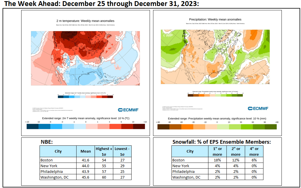
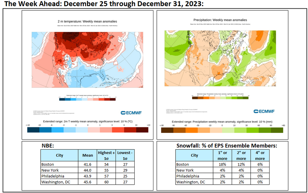
Latest snowfall outlook with EPS ensemble members and the NBE for NYC: The forecast pattern is an AO-/NAO-/PNA- one. Since 1950, there were 26 days during January 1-15 that saw measurable snowfall. 50% saw less than 1" while 50% saw 1" or more (daily snowfall not storm total snowfall). Nearly one-third (31%) saw 2" or more while 8% saw 4" or more (both cases were 6.3" and 6.4" respectively). However, there was a single case that saw the low temperature remain at or above 30° (33° low). That case had just 0.1". This data provides a rough picture of what may lie ahead keeping in mind the importance of details such as the soundings during the storm, etc. This will very likely be a relatively low ratio snowfall for the NYC area. For now, based on the above data, there remains a realistic chance that NYC could pick up an inch or more of snow (whether 1" or more falls on one day to break the record 688-day streak without such snowfall remains to be seen). It remains unlikely that NYC will pick up 6" or more snowfall, which would also fit historic experience for January 1-10 following cases where the AO reached +3..000 or above during December 15-25.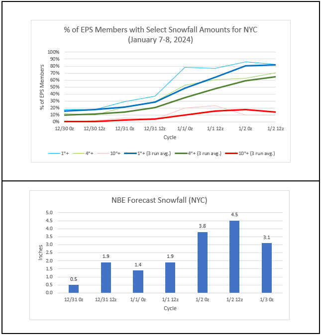
- 3,610 replies
-
- 2
-

-
- snow
- heavy rain
- (and 5 more)
-
Cool, dry weather will continue through the remainder of the week. A few locations could see a rain or snow shower on Thursday morning. Overall, the first week of January remains in line for near normal to somewhat above normal temperatures. That is quite a contrast from the much greater warmth that had prevailed through most of December. A storm could bring measurable snowfall to the region during January 7-8. There are currently two leading scenarios. The first involves significant snow (6" or more) falling well north and west of an area that includes Philadelphia and New York City. The second involves significant snowfall extending south and east into the area that includes New York City and Philadelphia. The first scenario is currently more likely than the second. Nevertheless, details remain to be worked out. Afterward, a major storm could bring a heavy windswept rain to much of the region during the middle of next week. The potential exists for a 1"-3" rainfall with locally higher amounts. Temperatures could surge toward or into the 50s. The ENSO Region 1+2 anomaly was +0.8°C and the Region 3.4 anomaly was +2.0°C for the week centered around December 27. For the past six weeks, the ENSO Region 1+2 anomaly has averaged +1.55°C and the ENSO Region 3.4 anomaly has averaged +2.00°C. A basinwide El Niño event is ongoing. The SOI was +0.10 today. The preliminary Arctic Oscillation (AO) was -1.468 today. Strong blocking in the final week of November, as occurred this year, has often been followed by frequent blocking in December and January. On December 31 the MJO was in Phase 2 at an amplitude of 1.894 (RMM). The December 30-adjusted amplitude was 2.047 (RMM).
-
Two Mdt to high impact events NYC subforum; wknd Jan 6-7 Incl OBS, and mid week Jan 9-10 (incl OBS). Total water equiv by 00z/11 general 2", possibly 6" includes snow-ice mainly interior. RVR flood potential increases Jan 10 and beyond. Damaging wind.
donsutherland1 replied to wdrag's topic in New York City Metro
Hopefully, the storm won’t be as wet as currently appears.- 3,610 replies
-
- 7
-

-
- snow
- heavy rain
- (and 5 more)
-
Two Mdt to high impact events NYC subforum; wknd Jan 6-7 Incl OBS, and mid week Jan 9-10 (incl OBS). Total water equiv by 00z/11 general 2", possibly 6" includes snow-ice mainly interior. RVR flood potential increases Jan 10 and beyond. Damaging wind.
donsutherland1 replied to wdrag's topic in New York City Metro
Even as attention is focused on the possible snowfall for late Saturday into Sunday, perhaps the bigger story for the first half of January will be the potential rainstorm for January 9-10. Already, there is an impressive signal on the ECMWF's Extreme Forecast Index (EFI) guidance: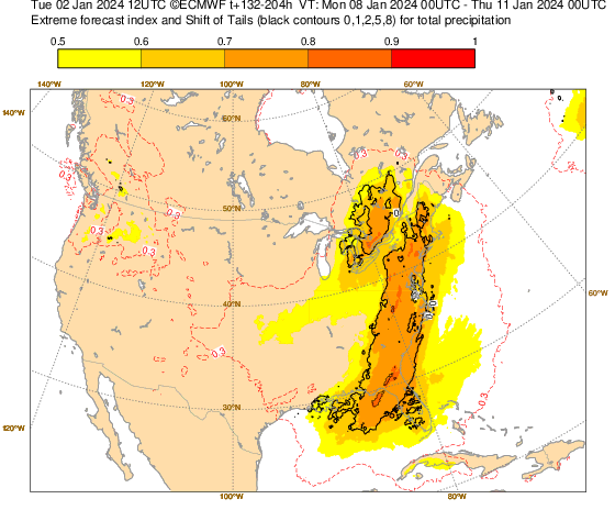
- 3,610 replies
-
- 8
-
-
-

-
- snow
- heavy rain
- (and 5 more)
-
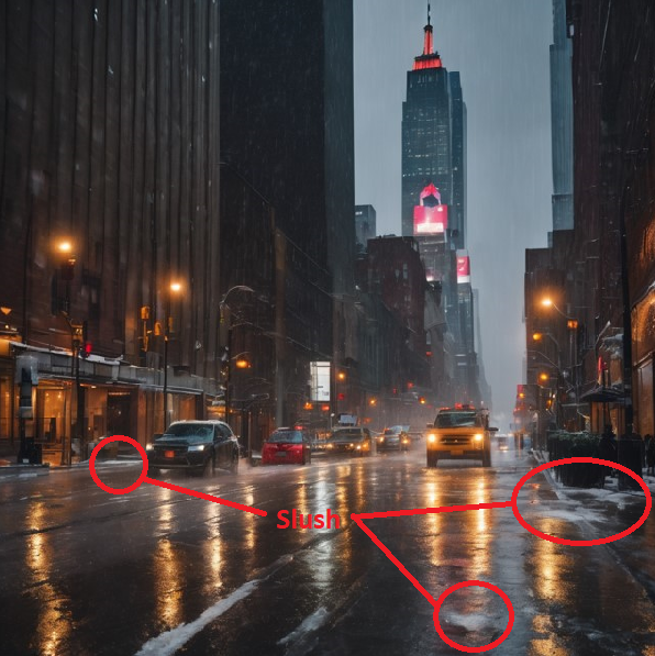
Afternoon thoughts: Lengthy streaks during which Atlantic City, Baltimore, New York City, and Philadelphia have not seen 1" or more daily snowfall continue today. Today, the streak will reach 703 days at Atlantic City (2nd longest). The streaks will reach a record 688 days at New York City (Central Park), 703 days at Philadelphia, and 704 days at Baltimore. But there is some possibility that these streaks could be nearing their end in a number of these locations. Although there are now early indications that a trough in the West will influence the track of a storm that will impact the region from late Saturday into Sunday, prospects for at least a measurable snowfall are higher than they have been this winter on a regionwide basis. At present, a 1" to perhaps 3" snowfall still seems plausible for Baltimore, New York City, and Philadelphia. Temperatures will likely remain above freezing for much of the storm in those areas. Atlantic City will likely fall short of 1" daily snowfall, allowing its ongoing streak to continue to advance toward that City's record (715 days). There continue to be more downside risks than upside ones. The two leading scenarios involve the storm's passing close enough to the coast to bring abundant warm air in along the coastal plain resulting in low snowfall amounts for the big cities. The other meaningful scenario involves the storm's taking a track farther south and east, allowing for a moderate snowfall even in the big cities. Taking into consideration the trough that will be anchored in the Southwest, a suppressed solution appears unlikely. The timing of the storm is sufficiently far out that the models can have errors of 25-50 miles. Such an error could make the difference between little or no accumulating snow or a moderate snowstorm.
-
Climate change is likely playing an important role through the impact of a warming North Pacific Ocean. There was a paper on this in 2021: https://www.nature.com/articles/s41558-020-00966-8
-
I felt nothing but heard the rumbling.
-
Some NYC residents saw the 12z GEFS and what it portends: They reacted strongly. The result: Notification issued 01-02-2024 at 11:26 AM. The United States Geological Survey (USGS) reports that a 1.7 magnitude earthquake has occurred near Astoria, Queens. The earthquake has reportedly been felt in the New York City area, but there are no reports of injuries or damage in New York City at this time.
-
Both the NAO and EPO were predominantly positive during December.
-
Two Mdt to high impact events NYC subforum; wknd Jan 6-7 Incl OBS, and mid week Jan 9-10 (incl OBS). Total water equiv by 00z/11 general 2", possibly 6" includes snow-ice mainly interior. RVR flood potential increases Jan 10 and beyond. Damaging wind.
donsutherland1 replied to wdrag's topic in New York City Metro
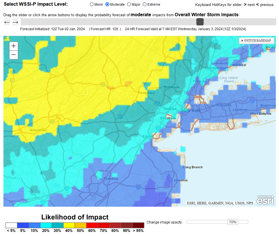
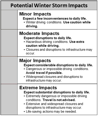
From the WPC's Probabilistic Winter Storm Severity Index tool: Moderate Impact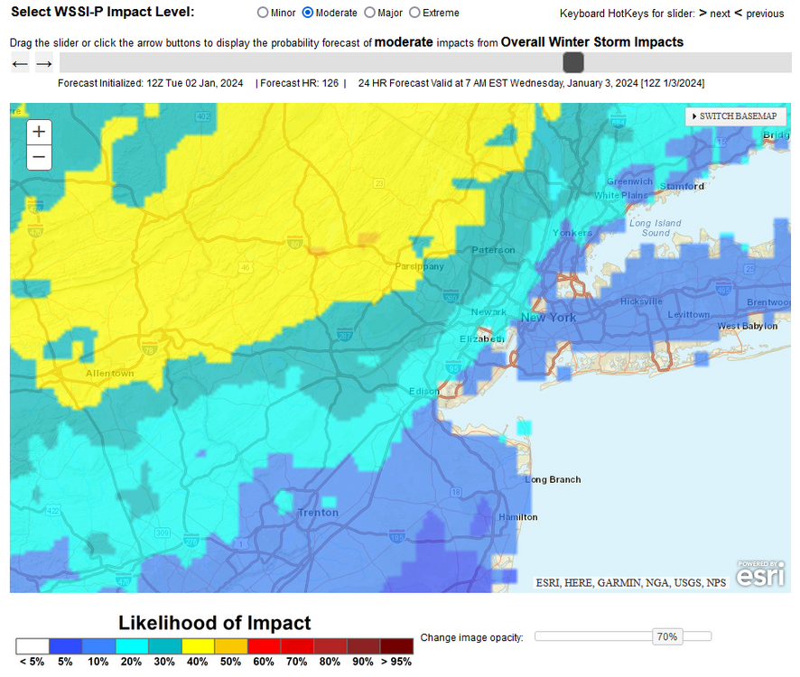
- 3,610 replies
-
- 6
-
-
-
- snow
- heavy rain
- (and 5 more)
-
Two Mdt to high impact events NYC subforum; wknd Jan 6-7 Incl OBS, and mid week Jan 9-10 (incl OBS). Total water equiv by 00z/11 general 2", possibly 6" includes snow-ice mainly interior. RVR flood potential increases Jan 10 and beyond. Damaging wind.
donsutherland1 replied to wdrag's topic in New York City Metro
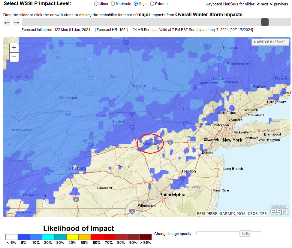
Even as there remains considerable uncertainty, it is unlikely that Allentown will see 12"-18" of snow. The potential exists for 6"-12" if things come together. Select Data: 1/2 0z NBE: 6.2" (the 2z increased the snowfall to 9.0") 1/1 12z EPS Members: 12" or more: 20%; 18" or more: 2% WPC Probabilistic Winter Storm Severity Index for Major Impact: < 5% (around 20% for a moderate impact)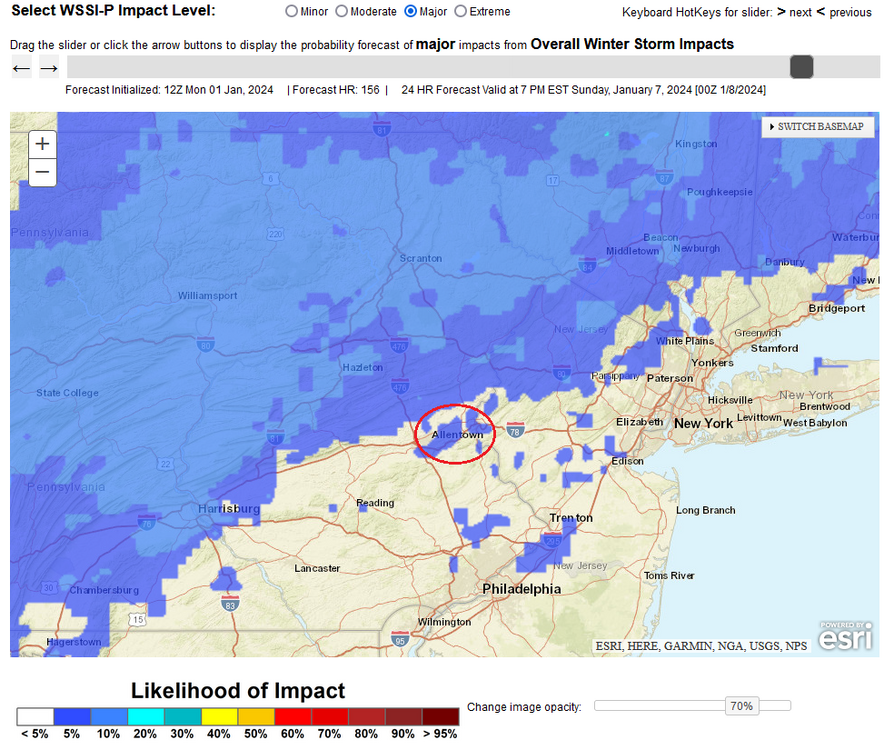
- 3,610 replies
-
- 2
-
-
-
- snow
- heavy rain
- (and 5 more)
-
2024 kicked off with benign weather. The temperature rose into the middle 40s as the clouds broke for a time. The first week of January will likely feature generally near normal to somewhat above normal temperatures. Severe cold is unlikely. Some snow flurries and snow showers are possible Thursday morning. There is the possibility that a significant storm could bring measurable snowfall to the region during January 7-8. Details remain to be worked out. The ENSO Region 1+2 anomaly was +1.6°C and the Region 3.4 anomaly was +2.0°C for the week centered around December 20. For the past six weeks, the ENSO Region 1+2 anomaly has averaged +1.75°C and the ENSO Region 3.4 anomaly has averaged +1.98°C. A basinwide El Niño event is ongoing. The SOI was -2.63 today. The preliminary Arctic Oscillation (AO) was -1.779 today. Strong blocking in the final week of November, as occurred this year, has often been followed by frequent blocking in December and January. On December 30 the MJO was in Phase 2 at an amplitude of 2.047 (RMM). The December 29-adjusted amplitude was 1.993 (RMM).
-
As has become increasingly common in recent years, the New Year begins with a range of flowers in bloom in the NYC area. Cherry blossoms are in bloom in Central Park. Camelia, Mahonia, and Witch Hazel are in bloom in the New York Botanical Garden.


-
Two Mdt to high impact events NYC subforum; wknd Jan 6-7 Incl OBS, and mid week Jan 9-10 (incl OBS). Total water equiv by 00z/11 general 2", possibly 6" includes snow-ice mainly interior. RVR flood potential increases Jan 10 and beyond. Damaging wind.
donsutherland1 replied to wdrag's topic in New York City Metro
Nice jump on the 15z NBE for NYC (3.8"). Let's see where things are in a few days. There may be some basis to increase confidence in a 1"-3"/2"-4" snowfall (a "great storm" by winter 2022-23 standards). Interior sections appear most likely to see a significant (6"+) snowfall.- 3,610 replies
-
- 1
-
-
- snow
- heavy rain
- (and 5 more)
-
Two Mdt to high impact events NYC subforum; wknd Jan 6-7 Incl OBS, and mid week Jan 9-10 (incl OBS). Total water equiv by 00z/11 general 2", possibly 6" includes snow-ice mainly interior. RVR flood potential increases Jan 10 and beyond. Damaging wind.
donsutherland1 replied to wdrag's topic in New York City Metro
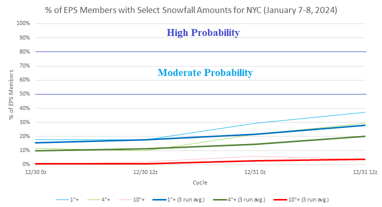
Latest EPS ensemble and NBE depictions of the January 7-8, 2024 storm: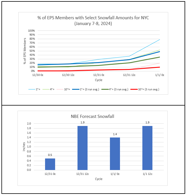
- 3,610 replies
-
- 2
-
-
-
- snow
- heavy rain
- (and 5 more)
-
Final Numbers: Warmer than had been shown.
-
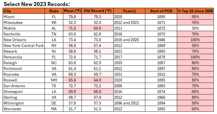
The warmest year on record globally is coming to a close. Numerous U.S. cities, including New York City, also experienced their warmest year on record. Some highlights:
-
New York City's second warmest December on record is concluding with a monthly mean temperature of 44.6° (5.5° above normal). 2023 has become New York City's warmest year on record with an annual mean temperature of 58.0° (old record: 57.4°, 2012). Additional cities in the Northeast experiencing their warmest year on record included: Albany, Baltimore, Islip, Newark, Sterling, and Worcester. The first week of January will likely feature generally near normal to somewhat above normal temperatures. Severe cold is unlikely. Initially, the arrival of a colder regime could coincide with a drier one, so snowfall prospects will remain limited until near the end of the week or start of the following week. There is the possibility that a storm could bring measurable snowfall to the region during January 7-8 with interior sections likely to see the largest amounts. Details remain to be worked out and there is a risk that the storm could cut toward the Great Lakes Region. The ENSO Region 1+2 anomaly was +1.6°C and the Region 3.4 anomaly was +2.0°C for the week centered around December 20. For the past six weeks, the ENSO Region 1+2 anomaly has averaged +1.75°C and the ENSO Region 3.4 anomaly has averaged +1.98°C. A basinwide El Niño event is ongoing. The SOI was +12.20 today. The preliminary Arctic Oscillation (AO) was -1.865 today. Strong blocking in the final week of November, as occurred this year, has often been followed by frequent blocking in December and January. 55% of days in December saw the AO below 0.000, including 39% where the AO was -1.000 or below. On December 29 the MJO was in Phase 1 at an amplitude of 1.993 (RMM). The December 28-adjusted amplitude was 2.103 (RMM).
-
The EPS ensembles have "discovered" the potential January 7-8, 2024 storm. But there remains considerable uncertainty with a risk that a Pacific trough could result in the storm's taking a track too far to the north and west to bring a moderate or significant snowfall to big cities from Philadelphia to New York City.
-
Feel free to do so, Walt. Have a great New Year.
-
DCA _ NYC _ BOS __ ORD _ ATL _ IAH __ DEN _ PHX _ SEA 1.1 1.4 1.6 2.2 -0.1 -0.2 -0.3 -0.4 1.2
-
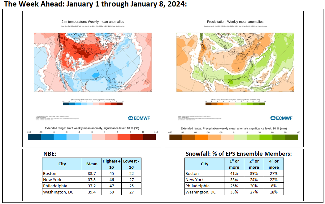
Week ahead numbers: If the above guidance is accurate, the long-awaited pattern change will arrive largely on schedule for the first week of January. The January 1-7 period will be the coldest 7-day period so far this winter. Severe cold remains unlikely. There will also be the prospect of snowfall, especially as the period closes. From this far out, even if a Pacific trough results in the potential 1/7-8 storm tracking toward the Great Lakes, prospects for at least a measurable snowfall are higher than they have been this winter on a regionwide basis.

-
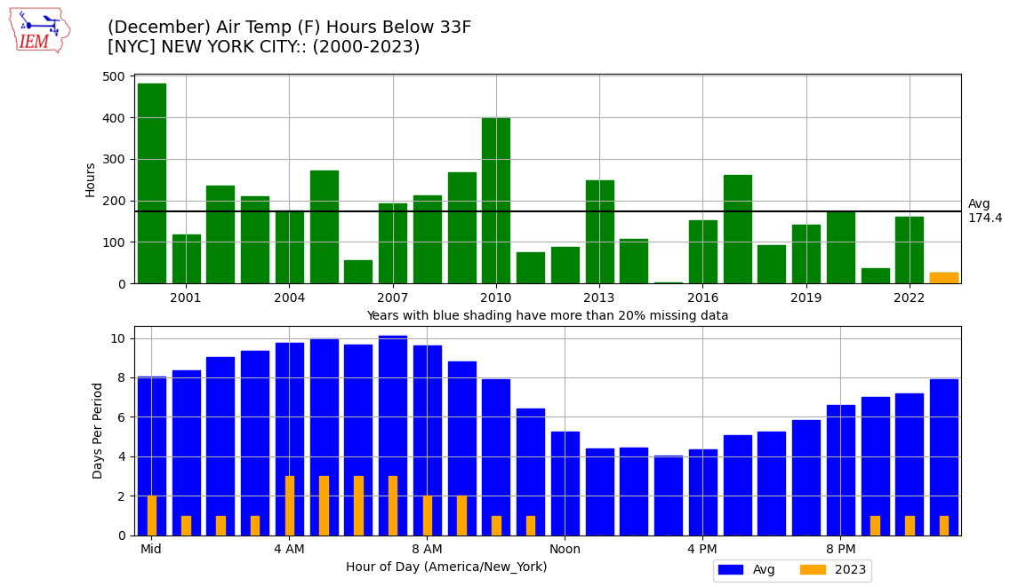
Recent years have seen fewer hours during which the temperature was 32° or below in December:

-
New York City's second warmest December on record is nearing an end. Temperatures will remain somewhat above seasonal norms as 2023 wraps up as New York City's warmest year on record with an annual mean temperature of 58.0° (old record: 57.4°, 2012). The first week of January will likely feature somewhat below normal temperatures. However, severe cold appears unlikely. Initially, the arrival of a colder regime could coincide with a drier one, so snowfall prospects will remain limited. The second week of January could offer better opportunities for snowfall, as the retreat of cold air could occur while the pattern becomes wetter. There remains some uncertainty concerning the magnitude and duration of the colder period that could develop. At this time, it appears more likely than not that it will be seasonably cold or somewhat colder than normal with a duration of 1-2 weeks. The ENSO Region 1+2 anomaly was +1.6°C and the Region 3.4 anomaly was +2.0°C for the week centered around December 20. For the past six weeks, the ENSO Region 1+2 anomaly has averaged +1.75°C and the ENSO Region 3.4 anomaly has averaged +1.98°C. A basinwide El Niño event is ongoing. The SOI was +10.74 today. The preliminary Arctic Oscillation (AO) was -1.505 today. Strong blocking in the final week of November, as occurred this year, has often been followed by frequent blocking in December and January. On December 28 the MJO was in Phase 1 at an amplitude of 2.103 (RMM). The December 27-adjusted amplitude was 2.028 (RMM). Based on sensitivity analysis applied to the latest guidance, there is an implied near 100% probability that New York City will have a warmer than normal December (1991-2020 normal). December will likely finish with a mean temperature near 44.5° (5.4° above normal). That would make December 2023 the 2nd warmest December on record. With 2023 virtually certain to be among the 10 warmest Decembers on record, 60% of New York City's 10 warmest Decembers have occurred since 2000, including 40% since 2010, and all have occurred since 1980. Records go back to 1869.