donsutherland1
-
Posts
24,194 -
Joined
Content Type
Profiles
Blogs
Forums
American Weather
Media Demo
Store
Gallery
Everything posted by donsutherland1
-
I think the focus on a light event is warranted until there is more support for something bigger. The GFS is too aggressive. Apparently, a social media account compared the upcoming event to the February 1969 Lindsay Storm (15.3” in NYC and 20.2” at JFK). But that account didn’t tell a key part of the story: the temperature for that storm fell from 34 into the middle 20s. Most of the precipitation fell with readings that were below freezing. That’s not the case this time around. Were there a similar air mass, then we’d be looking at a significant snowfall. One other omission, the 1969 storm was much wetter than what is likely this time: NYC: 1.82” and JFK: 2.49”.
-
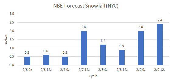
It comes out hourly, but I post the 0z and 12z numbers.
-
Recent NBE estimates for NYC:
-
Several inches is something that's on the table. 6" or above is unlikely.
-
Its deepening will bring in some colder air, but the overall air mass involved isn’t especially cold. There might be some moderate wet snow at the height of the storm, but it will be a fast mover. Most of its precipitation will fall over a 12-hour period and it won’t all be accumulating snow.
-
Early thoughts: The February 13th storm will very likely be another classic low ratio storm (under 5:1) where 10:1 snowfall maps will overstate the potential snowfall. During the storm, readings will remain well above freezing (possibly 35 or above). At present, the WPC probabalistic winter storm severity index map gives the NYC area about a 20% probability of a minor event. Select part of the WPC probabilistic winter storm severity index map (Minor Impact): The 6z GFS is the most aggressive model. It takes the temperature down to 33 and its soundings are consistent with a wet snow event. Given the marginal air mass involved and differences with the other guidance, including the warmer NBE and warmer 0z GFS MOS, it makes sense to wait for other guidance before buying into the GFS's idea. For now, the idea of a light event seems to be a reasonable course until there is strong and consistent support for something bigger.
-
The warming trend continues. Temperatures rose into the 50s across the region today. Even warmer temperatures lie ahead. The temperature will likely peak in the middle or upper 50s in New York City and into the 60s in Philadelphia and Washington, DC on Saturday. The generally mild conditions will likely continue into at least the second week of February with only brief interruptions. No Arctic air is likely to reach the area during this time. As a result, the first 10 days of February will likely wind up 5°-7° above normal in New York City. New York City will very likely see a mean temperature of 40.0° or above during the February 1-10 period. Since 1869, there have been 9 prior cases. Five have occurred since 2000 and eight have occurred since 1990: 1952, 1990, 1991, 1999, 2005, 2008, 2012, 2016, and 2020. Seven of those nine years saw less than 10" snowfall for the remainder of the season following February 10th. Only one saw more than 20.0" (22.7", 2005). The least was the trace of snow that fell in 2020. The mean snowfall was 7.2" while the median snowfall was 6.0". In short, were the February 1-10 temperature to average 40.0° or above, that development could be a reinforcing signal for a below to much below normal snowfall season. The second week of February will likely see the evolution toward a sustained colder pattern begin late that week preceded by a storm. That storm could affect the region early next week. There is a possibility that the rain could mix with or end as a period of wet snow or flurries in parts of the region. Temperatures will likely remain above freezing throughout the duration of the storm. Single-digit cold is unlikely in New York City following the pattern change. During February, cases with warm ENSO Region 1+2 anomalies see such lows at 55% of frequency as cold ENSO Region 1+2 cases during El Niño winters. During the second half of February, just 17% of cases with a PDO- saw single-digit cold during El Niño winters. January saw a strongly negative PDO. The ENSO Region 1+2 anomaly was +1.0°C and the Region 3.4 anomaly was +1.8°C for the week centered around January 31. For the past six weeks, the ENSO Region 1+2 anomaly has averaged +0.87°C and the ENSO Region 3.4 anomaly has averaged +1.83°C. A basinwide El Niño event is ongoing. The ongoing El Niño event will continue to fade through much of February. The SOI was -32.23 today. The preliminary Arctic Oscillation (AO) was -1.565 today. On February 6 the MJO was in Phase 7 at an amplitude of 2.271 (RMM). The February 5-adjusted amplitude was 2.080 (RMM). Based on sensitivity analysis applied to the latest guidance, there is an implied 67% probability that New York City will have a warmer than normal February (1991-2020 normal). February will likely finish with a mean temperature near 37.7.° (1.8° above normal).
-
I don't know enough about the war's impact to address that issue. There had been a general decline in average winter precipitation from the late 1930s bottoming out at the end of the 1960s.
-
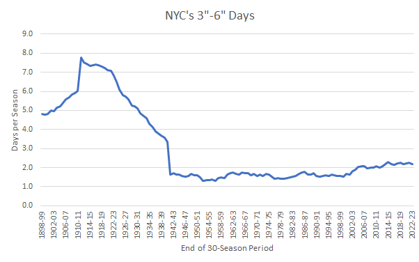
It's certainly plausible. I have greater confidence in the 30-season moving averages starting at 1980 and running through 2022-23.
-
I agree. I suspect that this development is an indication that the New York City area could be in the early stages of a transition toward a lower snowfall state due to the ongoing warming with the 30-season average falling to around 20" by the mid-2030s. A bad cycle may be amplifying the drop in snowfall.
-
Here are the graphed outcomes:
-
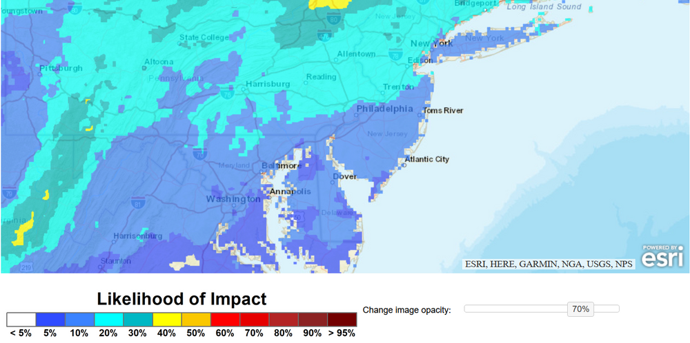
The map could reflect the scenario where it could be snowing where precipitation is falling more heavily and raining elsewhere. While it's possible that the event could end as some wet snow in and around the NYC area and adjacent NJ, if the MOS forecasts are accurate, the ratios would be very low resulting in little or no accumulation (probably none in the City). This is yet another marginal air mass, at best.
-
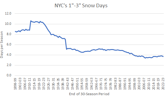
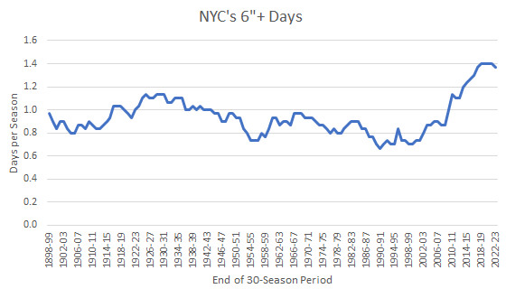
NYC Statistics on the Number of Snow Events: Early Recorded Climate: 1869-1870 through 1898-1899: 1"-3" days: 8.5 per winter 6"+ days: 1.0 per winter More Recent Climate: 1961-1962 through 1990-1991: 1"-3" days: 4.7 per winter 6"+ days: 0.7 per winter 1991-1992 through 2020-2021: 1"-3" days: 3.8 per winter 6"+ days: 1.4 per winter
-
It was a Flop... February 2024 Disco. Thread
donsutherland1 replied to Prismshine Productions's topic in New England
Thank you for the kind words. The data was pulled from the xmACIS database. A graph was then constructed based on the data. -
A warming trend is now underway. The temperature could rise well into the 50s in New York City and into the 60s in Philadelphia and Washington, DC late in the week and early in the weekend. The generally mild conditions will likely continue into at least the second week of February with only brief interruptions. No Arctic air is likely to reach the area during this time. As a result, the first 10 days of February could wind up 5°-7° above normal in New York City. New York City will likely see a mean temperature of 40.0° or above during the February 1-10 period. Since 1869, there have been 9 prior cases. Five have occurred since 2000 and eight have occurred since 1990: 1952, 1990, 1991, 1999, 2005, 2008, 2012, 2016, and 2020. Seven of those nine years saw less than 10" snowfall for the remainder of the season following February 10th. Only one saw more than 20.0" (22.7", 2005). The least was the trace of snow that fell in 2020. The mean snowfall was 7.2" while the median snowfall was 6.0". In short, were the February 1-10 temperature to average 40.0° or above, that development could be a reinforcing signal for a below to much below normal snowfall season. The second week of February will likely see the evolution toward a sustained colder pattern begin late that week. A storm could affect the region early next week. There is a possibility that the rain could mix with or end as a period of wet snow or flurries in parts of the region. Single-digit cold is unlikely in New York City following the pattern change. During February, cases with warm ENSO Region 1+2 anomalies see such lows at 55% of frequency as cold ENSO Region 1+2 cases during El Niño winters. During the second half of February, just 17% of cases with a PDO- saw single-digit cold during El Niño winters. January saw a strongly negative PDO. The ENSO Region 1+2 anomaly was +1.0°C and the Region 3.4 anomaly was +1.8°C for the week centered around January 31. For the past six weeks, the ENSO Region 1+2 anomaly has averaged +0.87°C and the ENSO Region 3.4 anomaly has averaged +1.83°C. A basinwide El Niño event is ongoing. The ongoing El Niño event will continue to fade through much of February. The SOI was -39.05 today. The preliminary Arctic Oscillation (AO) was -1.342 today. On February 5 the MJO was in Phase 7 at an amplitude of 2.080 (RMM). The February 4-adjusted amplitude was 2.092 (RMM). Based on sensitivity analysis applied to the latest guidance, there is an implied 70% probability that New York City will have a warmer than normal February (1991-2020 normal). February will likely finish with a mean temperature near 38.0° (2.1° above normal).
-
It was a Flop... February 2024 Disco. Thread
donsutherland1 replied to Prismshine Productions's topic in New England
It’s unfortunate that measurements aren’t made at a location such as Boston Common. -
It was a Flop... February 2024 Disco. Thread
donsutherland1 replied to Prismshine Productions's topic in New England
That’s true, but it’s still a high profile location with lots of people. -
The number will be very high and there will likely be a high number of major hurricanes, some of which will probably make landfall. It’s tough to know right now where the highest risk of landfall might be.
-
It was a Flop... February 2024 Disco. Thread
donsutherland1 replied to Prismshine Productions's topic in New England
Hopefully, the snow drought will end soon. -
It was a Flop... February 2024 Disco. Thread
donsutherland1 replied to Prismshine Productions's topic in New England
Today will be Boston's 712th consecutive day without daily snowfall of 4" or more. That will surpass the record of 711 days that was set during February 7, 1985 through January 18, 1987 and tied during February 28, 2011 through February 7, 2013.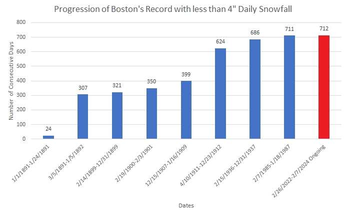
-
This season has me really concerned. The combination of historic Atlantic Ocean warmth and an emergent La Niña is worrisome.
-
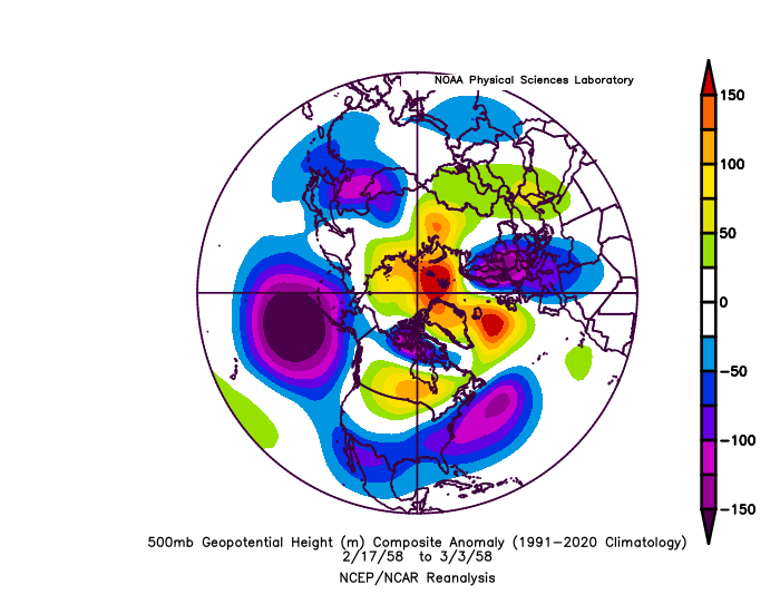
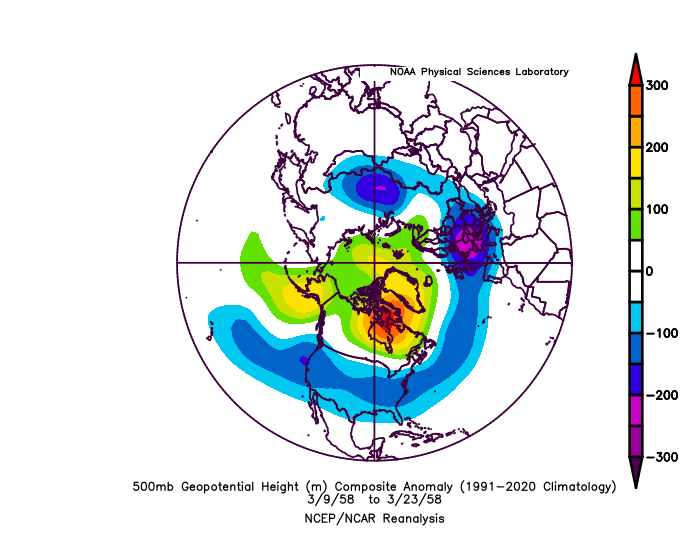
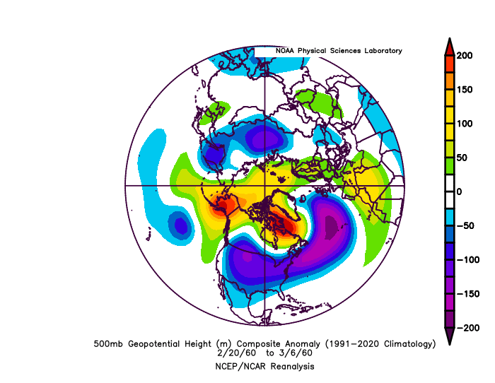
Certainly. As March 1958 was raised and part of that month saw similar teleconnections leading up to a big storm, here it is: Also, late February-March 1960: Notice no deep 500 mb low near the Aleutians nor an overpowering 500 mb low well off New England (more uniform trough depth).
-
Yes. But we won't have anything close to a HECS leading up to mid-month. Then, we'll have to wait perhaps for awhile. Late February-early March might afford the best opportunity. If there's going to be at least a moderate snowstorm, I suspect that it would occur within that window.
-
My concern this early on (and things should improve afterward) is that the above 500 mb chart is quite similar to a period that also was a "miss" as far as snowfall was concerned for the NYC and Philadelphia areas: February 17-March 3, 1958. New York City: Precipitation: 1.95"; Snow: 0.5" Philadelphia: Precipitation: 1.97"; Snow: Trace