donsutherland1
-
Posts
24,194 -
Joined
Content Type
Profiles
Blogs
Forums
American Weather
Media Demo
Store
Gallery
Everything posted by donsutherland1
-
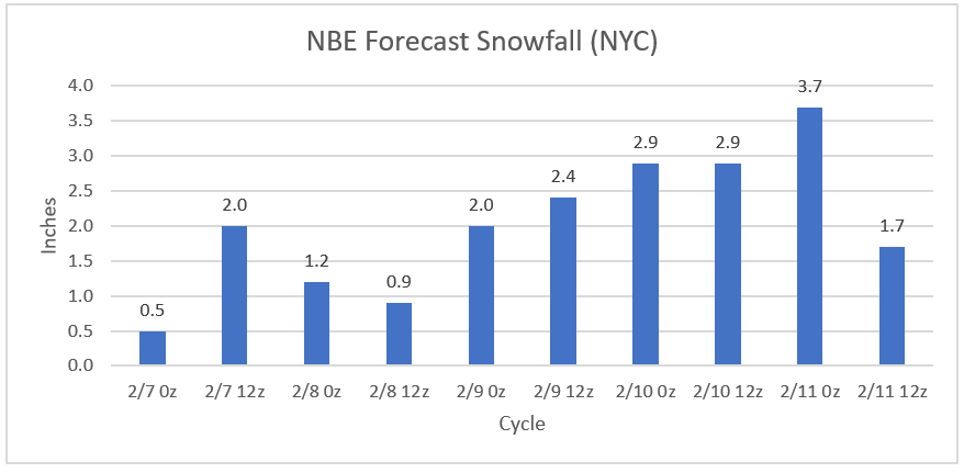
The 2/11 12z NBE has slashed its forecast snowfall amount to 1.7". It maintains a low temperature of 37.
-
No surprise. One needs to adjust for climate change. One also has to consider how marine heatwaves can distort patterns e.g., this could be the first strong El Niño event during which the PDO was negative in all three winter months. Ignoring such changes leaves one with a forecasting framework that is obsolete and often useless.
-
EWR: 60; JFK: 55; NYC: 60 (missed the record by 1 degree).
-
That was the April 1907 storm.
-
The 0z NBE has increased forecast snowfall to 3.7" in NYC, even as it increased its estimated low temperature to 37. Only a single case exists with such a snowfall and a low temperature of 35 or above. Either the NBE will reduce the estimated low temperature or future cycles will reduce snowfall amounts. I suspect it will be the latter, as occurred with the GFS MOS's moving from an estimated 4"-6" to trace to 2".
-
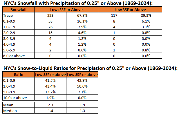
The 2/10 22z NBE currently forecasts a low of 36 degrees in New York City during the upcoming storm. The 12z GFS MOS is even more bleak with a low of 38 degrees. The MOS categorical snow outlook for NYC is trace to 2". The MOS categorical amount would fit more than 98% of historic cases with daily lows of 35 degrees or above and 0.25" or more of daily precipitation. For reference:
-
Today was an unseasonably warm day. Parts of the Northeast saw record warmth today. Records included: Albany: 60° (old record: 53°, 1955) Burlington: 56° (old record: 46°, 1925 and 2001) Concord: 60° (old record: 55°, 1876 and 1955) Hartford: 62° (tied record set in 2023) Manchester: 62° (old record: 56°, 1955) New York City-LaGuardia Airport: 60° (tied record set in 2001 and tied in 2023) Portland: 54° (old record: 52°, 1955 and 2023) Poughkeepsie: 59° (old record: 57°, 2023) Rochester: 58° (old record: 57°, 1881) Syracuse: 63° (old record: 59°, 1925) New York City concluded the first 10 days of February with a mean temperature of 42.1°. That was tied with February 1999 as the fourth warmest February 1-10 period on record. Six of the ten warmest such periods have occurred since 2000. Since 1869, there have been 9 prior cases with mean temperatures of 40.0° or above. Seven of those nine years saw less than 10" snowfall for the remainder of the season following February 10th. Only one saw more than 20.0" (22.7", 2005). The least was the trace of snow that fell in 2020. The mean snowfall was 7.2" while the median snowfall was 6.0". In short, were the February 1-10 temperature to average 40.0° or above, that development could be a reinforcing signal for a below to much below normal snowfall season, even as a storm could bring some snow to the region Monday night into Tuesday. The evolution toward a sustained colder pattern will likely begin preceded by the aforementioned storm. This will not be an especially cold pattern, but it will be noticeably colder than the pattern that defined the first 10 days of the month. Rain will likely change to wet snow in Newark and New York City Monday night or early Tuesday morning. The snow could fall at varying intensities. New York City and Newark could pick up 1" of snow. A small possibility exists for up to 3" of slushy snow. Higher accumulations are likely north and west of the cities. Temperatures will likely remain above freezing throughout most or all of the storm in New York City and adjacent areas holding down ratios and snowfall amounts. Single-digit cold is unlikely in New York City following the pattern change. During February, cases with warm ENSO Region 1+2 anomalies see such lows at 55% of frequency as cold ENSO Region 1+2 cases during El Niño winters. During the second half of February, just 17% of cases with a PDO- saw single-digit cold during El Niño winters. January saw a strongly negative PDO. The ENSO Region 1+2 anomaly was +1.0°C and the Region 3.4 anomaly was +1.8°C for the week centered around January 31. For the past six weeks, the ENSO Region 1+2 anomaly has averaged +0.87°C and the ENSO Region 3.4 anomaly has averaged +1.83°C. A basinwide El Niño event is ongoing. The ongoing El Niño event will continue to fade through much of February. The SOI was -39.53 today. The preliminary Arctic Oscillation (AO) was -1.580 today. On February 8 the MJO was in Phase 6 at an amplitude of 1.761 (RMM). The February 7-adjusted amplitude was 2.220 (RMM). Based on sensitivity analysis applied to the latest guidance, there is an implied 70% probability that New York City will have a warmer than normal February (1991-2020 normal). February will likely finish with a mean temperature near 37.7° (1.8° above normal). Winter 2023-2024 is on course to finish with a seasonal mean temperature of 39.4°-40.2°. That would rank the current winter among the ten warmest on record in New York City. It would also mark the second time when two consecutive winters have ranked among the top ten in terms of warmth. Winters 2015-2016 and 2016-2017 are currently the only two such winters to rank among the ten warmest on record. Should Winter 2023-2024 finish with a mean temperature of 40.0° or above, that would be the first time on record that New York City had seen two consecutive winters with such warmth.
-
Multiple EPS runs have now shown the EPO going positive just after the 20th of February. That wasn't the case previously and that situation bears watching. It could merely mean that the overall pattern is not very cold, but not necessarily warm through the remainder of the month. But there would likely be a few warm days popping up. I didn't see the upcoming pattern change as bringing severe cold to the region, so a signal for less cold isn't all that surprising. For now, I'll defer on whether this development means that the overall attempt at a sustained colder period will wind up failing. The 12z GFS with its persistent warmer than normal days in the extended range highlights a potential risk. Over the past 90 days, the ECMWF and EPS have had a cold bias while the GFS and GEFS have had a warm bias. Were the ECMWF or EPS to suddenly move into agreement toward a more sustained mild period, that would be noteworthy.
-
My current thinking is as follows: JFK: 0.5" to perhaps 2"; NYC: 1" to perhaps 3"; ABE: 3"-6"; MPO: 5"-10" The NYC-JFK-LGA-EWR area remains highly uncertain. Scenarios ranging from little or nothing to around 4" can't be ruled out. My thinking will be refined this evening.
-
JFK or ABE?
-
Latest EPS and NBE Outcomes:
-
The Euro was a good run. Hopefully, it will be right.
-
At the height of the storm, ratios could be fairly decent. The late-season storms with heavy snow (quarter mile or less visibility) were above 5:1. At that time, the temperature was typically 32-33. Hopefully, the later guidance will show somewhat colder readings.
-
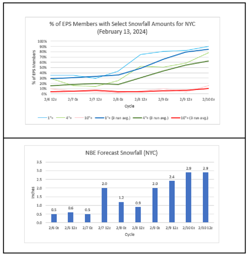
After seeing the 0z GFS, GGEM, ICON, and UKMET. I have not seen enough to move away from my initial thinking that this will could be a light accumulation event (after rain) in New York City. By that, I mean 1" to perhaps 3" of snow. Those numbers can be refined either upward or downward following tomorrow's guidance, which could begin to move into better consensus. It is encouraging that there remain some global models with at least a moderate event (after slashing 10:1 maps by 50%) in and around New York City, particularly the higher-scoring GGEM and UKMET. The 2/10 4z NBE also showed 3.0" for NYC, 2.6" for Newark, and 3.5" for White Plains. It remains concerning that much of the storm could occur with NYC's temperature holding at or above 35 degrees (the GFS MOS was not yet available at the time of this post). The elevated temperatures suggest that this will likely be a slushy low ratio snowfall (5:1 or below) that limits accumulations in New York City and Newark. Better rates and accumulations would be likely north and west of those cities.
-
Occasional Thoughts on Climate Change
donsutherland1 replied to donsutherland1's topic in Climate Change
It’s an interesting paper and it confirms “tipping” behavior related to the AMOC. Tipping abruptly from one stable state into another one has been found elsewhere, so I don’t believe it is too surprising that researchers found that the same could hold true for the AMOC. IMO, had they found against tipping, that would have been a more surprising outcome. The full paper is here: https://www.science.org/doi/10.1126/sciadv.adk1189 -
Today was another mild day with temperatures rising into the lower and middle 50s across the region. The temperature will likely peak in the middle or upper 50s in New York City and the 60s in Philadelphia and Washington, DC tomorrow. The generally mild conditions will likely continue into at least the second week of February with only brief interruptions. No Arctic air is likely to reach the area during this time. As a result, the first 10 days of February will likely wind up 5°-7° above normal in New York City. New York City will very likely see a mean temperature of 40.0° or above during the February 1-10 period. Since 1869, there have been 9 prior cases. Five have occurred since 2000 and eight have occurred since 1990: 1952, 1990, 1991, 1999, 2005, 2008, 2012, 2016, and 2020. Seven of those nine years saw less than 10" snowfall for the remainder of the season following February 10th. Only one saw more than 20.0" (22.7", 2005). The least was the trace of snow that fell in 2020. The mean snowfall was 7.2" while the median snowfall was 6.0". In short, were the February 1-10 temperature to average 40.0° or above, that development could be a reinforcing signal for a below to much below normal snowfall season. The second week of February will likely see the evolution toward a sustained colder pattern begin late that week preceded by a storm. That storm could affect the region early next week. There is a possibility that the rain could mix with or end as a period of wet snow or flurries in parts of the region. Parts of the region could pick up a light accumulation of snow. Temperatures will likely remain above freezing throughout most or all of the storm in New York City and adjacent areas. However, there is a degree of uncertainty. Single-digit cold is unlikely in New York City following the pattern change. During February, cases with warm ENSO Region 1+2 anomalies see such lows at 55% of frequency as cold ENSO Region 1+2 cases during El Niño winters. During the second half of February, just 17% of cases with a PDO- saw single-digit cold during El Niño winters. January saw a strongly negative PDO. The ENSO Region 1+2 anomaly was +1.0°C and the Region 3.4 anomaly was +1.8°C for the week centered around January 31. For the past six weeks, the ENSO Region 1+2 anomaly has averaged +0.87°C and the ENSO Region 3.4 anomaly has averaged +1.83°C. A basinwide El Niño event is ongoing. The ongoing El Niño event will continue to fade through much of February. The SOI was -46.54 today. That is the lowest SOI figure since May 24, 2023 when the SOI stood at -64.63. The preliminary Arctic Oscillation (AO) was -1.888 today. On February 7 the MJO was in Phase 6 at an amplitude of 2.220 (RMM). The February 6-adjusted amplitude was 2.271 (RMM). Based on sensitivity analysis applied to the latest guidance, there is an implied 67% probability that New York City will have a warmer than normal February (1991-2020 normal). February will likely finish with a mean temperature near 37.6.° (1.7° above normal).
-
My 12-year-old raises similar questions.
-
January 1961 was referenced last month. Even the Blizzard of 1978 (February) was referenced.
-
A great poem that fits this winter very well.
-
Yet another snowfall opportunity--at least as promised by the GFS--appears to be headed for life support and then its possible demise. A light event still remains plausible, but worries that such an event could also collapse abound. Tweeted calls for the 1961 Kennedy Inaugural storm and 1969 Lindsay storm, extreme 46-day snow maps, and calls for 0-degree readings in New York City, lie in ruins. There are even suggestions that Fall 2023 never really ended. Instead, fall will complete a smooth seasonal transition to Spring 2024 sometime next month. Maybe Taylor Swift's next album will feature "Cruel Winter?" So, what are area snow geese to do? Rely on memories of past storms? Those memories are growing hazier with the passage of time. What about younger members? Maybe the local art gallery or museum can refresh memories or remind one of what a snowy landscape looks like. And maybe Winter 2023-24 can muster up the ingredients needed for a decent snowfall before spring takes hold for good.

-
Technically, the GFS uses a different initialization scheme from the GGEM, ECMWF, and UKMET. The latter three use the 4dVAR scheme, which is the leading one. Initialization differences aside, there could be other reasons why the different models handle things differently. If, for example, the GGEM and ECMWF are diverging, other issues could be involved. Overall, all the models are still searching for the solution and it may take another day or so for there to be good consensus.
-
The ECMWF weeklies are wet from February 26-March 11. The very strongly negative SOI (lowest daily value since May 24, 2023) suggests an active subtropical jet within two weeks or so. So, there may be potential during that period, especially the first half where it looks to be colder than the second half.
-
12z was 4.1” at SWF.
-
More snow fell out at Queens and on parts of Long Island than Central Park in the 1969 storm. The storm total precipitation was quite a bit higher at JFK (2.49") than at Central Park (1.82"). JFK sometimes receives more snow depending on the storm's track, dynamics, etc.
-
Yes. There's really no meaningful comparison between that storm and the upcoming one.