donsutherland1
-
Posts
24,194 -
Joined
Content Type
Profiles
Blogs
Forums
American Weather
Media Demo
Store
Gallery
Everything posted by donsutherland1
-
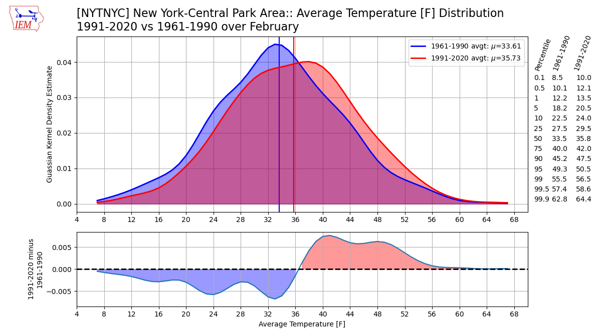
Below are some charts showing how February has warmed in the New York City area (1991-2020 vs. 1961-1990).

-
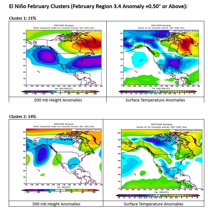
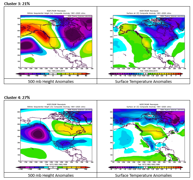
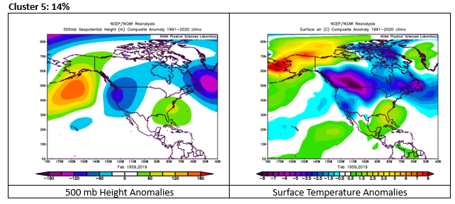
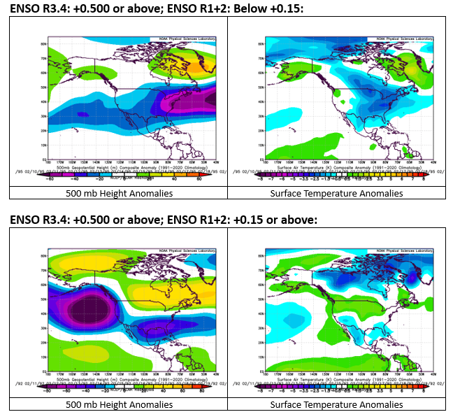
500 mb/Surface Temperature Anomalies for El Niño events with a February Region 3.4 average anomaly of +0.50°C or above and those broken down by select Region 1+2 data. The EPS weeklies are currently showing an evolution toward a pattern similar to Cluster 1. Cold would be less widespread and less significant, as the current background state is warmer. Cluster 1 is comprised of February 1958, 1969, and 2010. All of those cases favored a snowy February in the New York City area. However, persistent warmth in Region 1+2 favors Cluster 4. Cluster 4 typically sees more suppressed storms. Cluster 4 is comprised of February 1973, 1983, 1992, and 1998. February 1983 featured a major East Coast blizzard. The other cases saw a decided lack of snowfall. February 1958 was the single February case with a "warm" Region 1+2 (mean February anomaly of +0.15°C or above) that fell into Cluster 1.
-
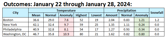
Final numbers for what had been an exceptionally warm and wet week in the Northeast.
-
Periods of light rain will likely continue to fall throughout the New York City area tonight. This rain could mix with or end as some wet snow or flurries tomorrow morning in New York City. Little or no accumulation is likely in New York City and Newark. Accumulating snow is likely well north and west of New York City and across central New England and in higher elevations. January will wind up as a solidly warmer than normal month and Winter 2023-24 will become yet another warmer than normal winter in the New York City and Philadelphia areas. The generally mild conditions will likely continue through the first week of February with only brief interruptions. The second week of February could see the evolution toward a sustained colder pattern. There has been some increase in uncertainty concerning the timing of such an evolution. The overall February outlook is unusually uncertain. The outcome will be a function of often counteracting forces: the decay of the strong El Niño/ENSO region developments, concurrent marine heatwaves, shifting teleconnections, tropical convection, and ongoing background warming, among other factors. The ECMWF weeklies continue to show a shift toward a sustained colder pattern near mid-month, which would be consistent with strong El Niño climatology. However, there are some cautionary notes. For example, if the ENSO Region 1+2 anomaly averages +0.15°C or above, that typically results in a warmer, less snowy outcome for New York City for February cases with ENSO Region 3.4 anomalies of +0.50°C or above than those with a colder average anomaly for Region 1+2 (NYC monthly mean temperature: 35.0° vs. 31.2°; NYC average monthly snowfall: 6.0" vs. 16.4"). February 2016 (4.0") was a recent example of a warmer Region 1+2 case. February 2010 (36.9") was a recent example of a colder Region 1+2 cases. There can be exceptions. One exception was February 1983 that saw 21.5" of snow, largely from a major blizzard, despite an average Region 1+2 anomaly of +1.55°C. The ENSO Region 1+2 anomaly was +0.8°C and the Region 3.4 anomaly was +1.7°C for the week centered around January 17. For the past six weeks, the ENSO Region 1+2 anomaly has averaged +1.10°C and the ENSO Region 3.4 anomaly has averaged +1.92°C. A basinwide El Niño event is ongoing. The ongoing El Niño event has recently peaked and will continue to fade. The SOI was -10.41 today. The preliminary Arctic Oscillation (AO) was +0.895 today. On January 26 the MJO was in Phase 6 at an amplitude of 2.423 (RMM). The January 25-adjusted amplitude was 2.390 (RMM). Based on sensitivity analysis applied to the latest guidance, there is an implied near 100% probability that New York City will have a warmer than normal January (1991-2020 normal). January will likely finish with a mean temperature near 36.8° (3.1° above normal).
-
Thanks. I'm not on there all the time. I've followed you. The above is an interesting list. I suspect a number of those weakest entries will be surpassed in the next decade.
-
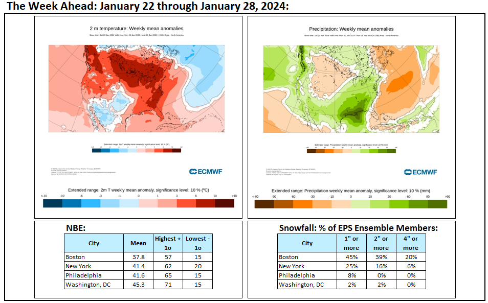
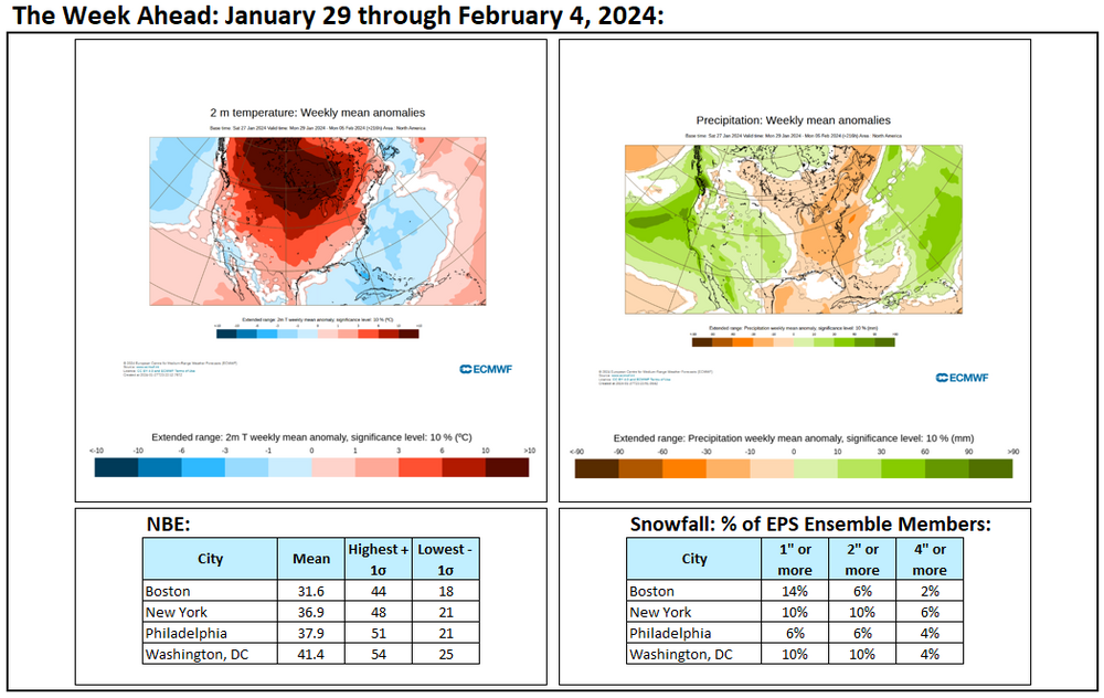
Week ahead numbers: Cooler than the prior week but a snowy outcome appears unlikely based on those numbers and forecast drier pattern.
-
Final EPS and NBE Numbers for a largely or wholly cold rain event in New York City and nearby areas. Little or no accumulation is likely there with no accumulation being of a higher probability. Higher elevations across northwest New Jersey into the Catskills should see some snow with accumulations likely at or above 1,000 feet. In the vicinity of Albany into western Massachusetts, higher elevations could pick up 3"-6" of snow.
-
No. There was very little wind.
-
In her, "In the bleak midwinter," 19th Century English poet Christina Rossetti wrote: In the bleak midwinter, frosty wind made moan, Earth stood hard as iron, water like a stone; Snow had fallen, snow on snow, snow on snow, In the bleak midwinter, long ago. In the northern Mid-Atlantic region, the kind of cold and snow that inspired Rossetti is nowhere to be found. That will remain the case therough the remainder of January. A storm will bring additional rain to the region late tonight into early Monday. The rain could mix with wet snow tomorrow morning and then end as a period of wet snow or flurries in New York City tomorrow night or Monday morning. Little or no accumulation is likely in New York City and Newark. Accumulating snow is likely well north and west of New York City and across central New England and in higher elevations. The remainder of January will likely wind up generally warmer than normal with the exception of perhaps a transient shot of cold. No strong Arctic shots are likely. As a result, January will wind up as a warmer than normal month and Winter 2023-24 will become yet another warmer than normal winter in the New York City and Philadelphia areas. The generally mild conditions will likely continue through the first week of February with only brief interruptions. The second week of February could see the evolution toward a sustained colder pattern. The ENSO Region 1+2 anomaly was +0.8°C and the Region 3.4 anomaly was +1.7°C for the week centered around January 17. For the past six weeks, the ENSO Region 1+2 anomaly has averaged +1.10°C and the ENSO Region 3.4 anomaly has averaged +1.92°C. A basinwide El Niño event is ongoing. The ongoing El Niño event has recently peaked and will continue to fade. The SOI was -3.29 today. The preliminary Arctic Oscillation (AO) was +0.981 today. On January 25 the MJO was in Phase 6 at an amplitude of 2.390 (RMM). The January 24-adjusted amplitude was 2.354 (RMM). Based on sensitivity analysis applied to the latest guidance, there is an implied near 100% probability that New York City will have a warmer than normal January (1991-2020 normal). January will likely finish with a mean temperature near 36.6° (2.9° above normal).
-
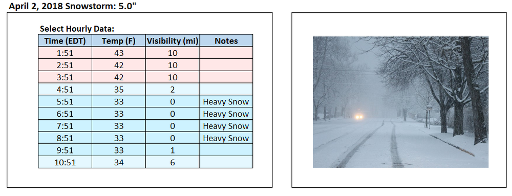
The surface temperature for the April 2, 2018 storm dropped to 33° and held there. The 1907 storm, for which hourly data is not available, had a low of 35°. Below is the data for the April 2, 2018 storm:
-
I made an error. That storm was April 2, 2018.
-
April 2, 2018: 5.5" (Low: 33)
-
April 9, 1907: 5.0" (Ratio: 5.4:1). Almost all of the snow fell before dawn. Total precipitation: 0.92". The snow fell heavily during the storm (very likely visibilities < 0.25 mile).
-
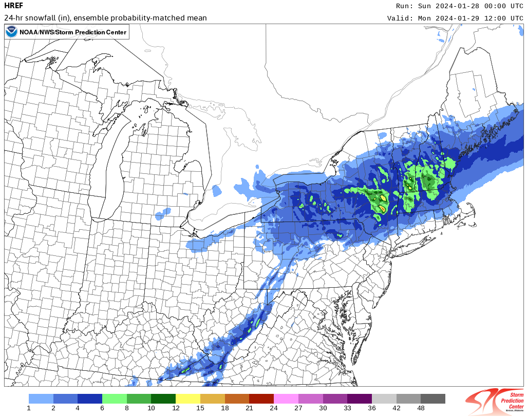
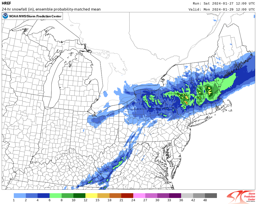
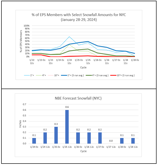
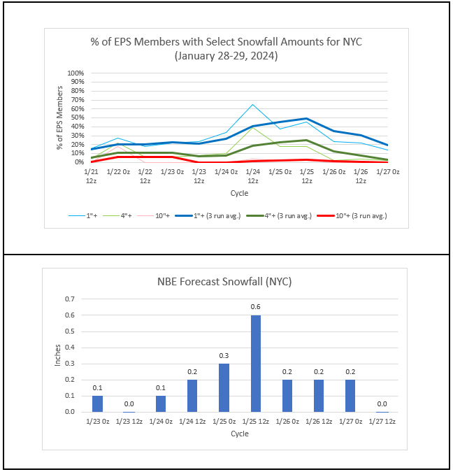
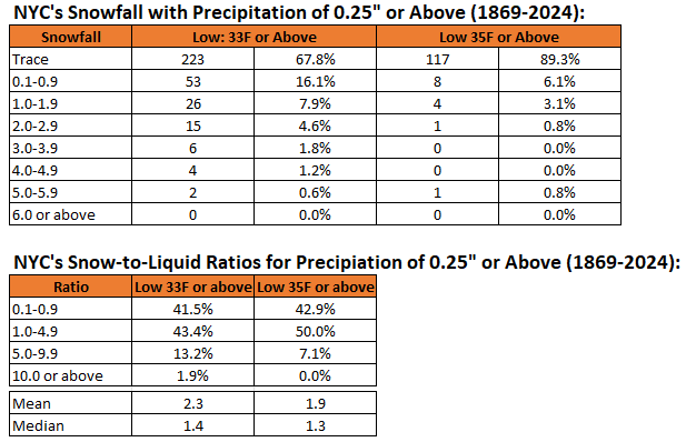
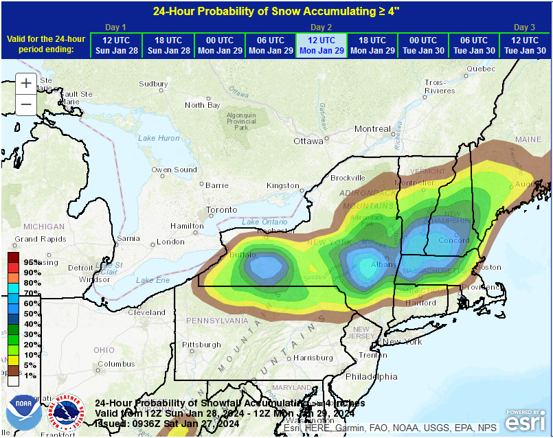
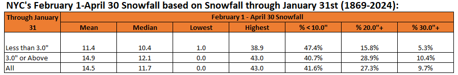
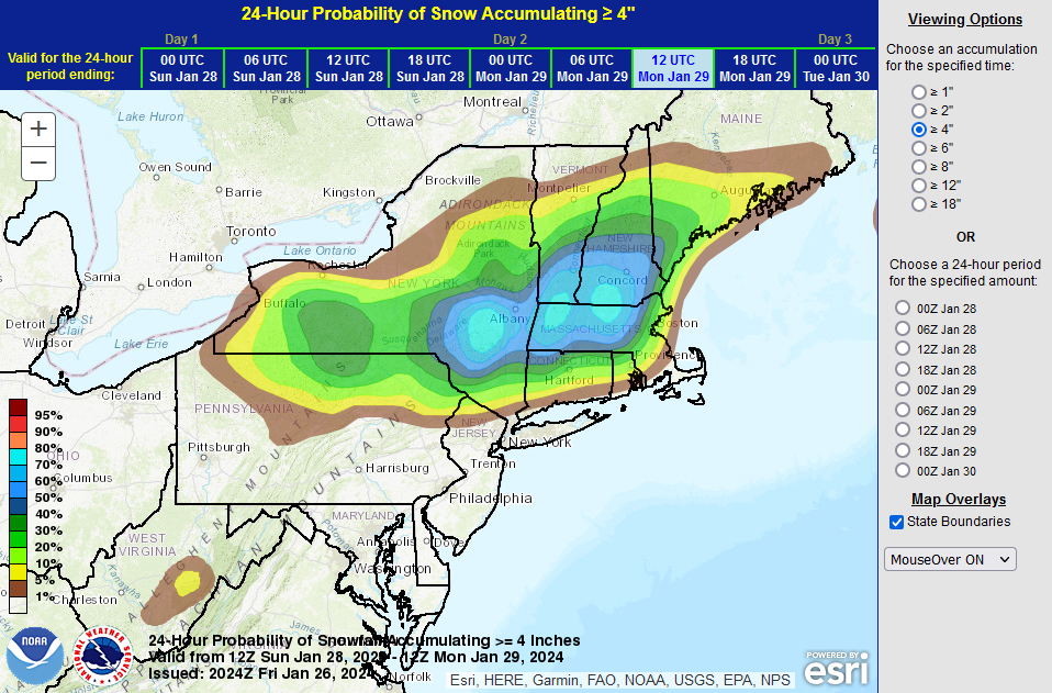
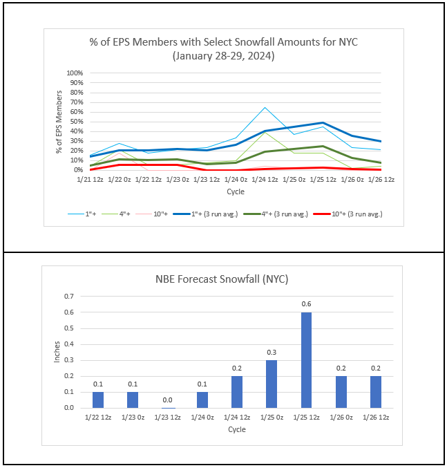
Overnight, the GFS returned to the land of model reality after having stood alone from the operational and mesocale models, along with all of the individual GEFS members. The higher elevations from I-84 to north and west of Albany could see 4" amounts with some locally higher amounts in excess of 6". At lower elevations, the highest accumulations will start to occur somewhere between I-84 and I-90. Given the marginal air mass, the temperature is likely to remain above freezing throughout the duration of the storm in New York City. Lowest temperatures: GFS MOS: 38°; NAM MOS: 37°; NBE: 38°. As a result, the snow-to-liquid ratios will be very low (very likely < 5:1) for any show that falls in and around New York City. The 1/27 0z EPS cycle saw 14% of members with 1" or more snow in New York City. However, given ratios of 5:1 or less, the 2" threshold is a better indicator of the probability of 1" or more snow. Just 6% of members saw 2" or more snow. In sum, Central Park will likely see little or no accumulation from this storm. New York City's and Newark's ongoing record streaks of 728 consecutive days without 2" or more snowfall will continue. Historic Snowfall Amounts and Snow-to-Liquid Ratios for Above Freezing Storms: 0.25" Precipitation or above Lows of 33 or above and 35 or above January 1, 1869 through January 26, 2024 EPS and NBE Numbers: WPC Guidance: With New York City very likely to see less than 3.0" snowfall through January 31st, the historic probability of seeing 20.0" or more or 30.0" or more during February 1-April 30 is lower than the historic average.
-
It’s not more precise, but the weather records are maintained in tenths of degrees. That virtually every other country uses it is also a benefit.
-
Not that I am aware of. I have seen some physical records and they are all in Fahrenheit.
-
That milestone will be reached on Monday. The cold could be arriving around the 10th and well in place by mid-month. I’m not yet sure whether there will be severe cold.
-
I prefer Celsius for that reason. Records are kept by tenths of degrees.
-
The final high was 80. The tweet was based on the value of 80.6. Sometimes, such values are off by a degree or so.
-
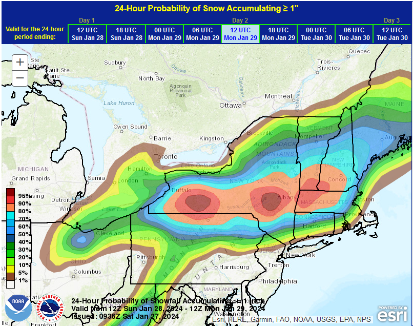
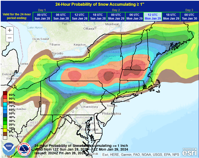
A storm will bring a moderate snowfall with some locally significant amounts to the higher elevations of the Catskills. For New York City, the storm will bring rain that could end as a period of wet snow or flurries. New York City's ongoing without daily snowfall of 2" or more--currently at 727 days today--will go on. Any snowfall amounts would be minor, as ratios will be very low. EPS and NBE Numbers: WPC 24-Hour Snowfall Probabilities: This outcome is consistent with past cases where the AO was +1.000 or above and the EPO was positive. As for the latest GFS run (18z), it is an outlier with no support from any other global model or mesoscale model. Moreover, all 31 members of the GEFS disagree with its solution. The most aggressive member of the GEFS shows just 1" of snow for New York City (actual amount would be lower as the ratios will be far less than 10:1). Finally, in the longer-range, it still appears that a pattern change toward consistently colder conditions will likely commence during the second week of February. Consistent with climatology associated with strong El Niño events, mid-month could see colder than normal conditions.
-
Today was another day ruled by clouds, mist, drizzle and light rain in the New York City and Newark areas. Temperatures were confined to the lower and middle 40s. At Philadelphia and Wilmington, DE, the mercury rose into the lower 50s. Farther south, it was a whole different season. The thermometer soared into the upper 70s and even 80°. Washington, DC reached 80°, setting a January monthly record. That was also its earliest 80° or above temperature on record (old record: February 21, 2018). High temperatures in parts of the Mid-Atlantic area included: Baltimore: 78° Charlottesville, VA: 80° (old record: 74°, 1950) Georgetown, DE: 73° Norfolk: 77° (tied record set in 1950) Richmond: 78° Salisbury, MD: 75° (old record: 73°, 1950) Sterling, VA: 79° (old record: 70°, 1967) ***New January record*** Wallops Island, VA: 76° (old record: 64°, 2017) ***New January record*** Washington, DC: 80° (old record: 79°, 1950) ***New January record*** Even with temperatures hanging on in the lower and middle 40s, overall readings were milder than the seasonal average. The remainder of January will likely wind up generally warmer than normal with the exception of perhaps a transient shot of cold. No strong Arctic shots appear likely. As a result, January will wind up as a warmer than normal month and Winter 2023-24 will become yet another warmer than normal winter in the New York City and Philadelphia areas. The generally mild conditions could continue into the first week of February with only brief interruptions. A storm will bring additional rain to the region later this weekend into early next week. The rain could end as a period of wet snow in New York City. Accumulating snow is likely well north and west of New York City and across central New England and in higher elevations. The ENSO Region 1+2 anomaly was +0.8°C and the Region 3.4 anomaly was +1.7°C for the week centered around January 17. For the past six weeks, the ENSO Region 1+2 anomaly has averaged +1.10°C and the ENSO Region 3.4 anomaly has averaged +1.92°C. A basinwide El Niño event is ongoing. The ongoing El Niño event has recently peaked and will continue to fade. The SOI was -2.40 today. The preliminary Arctic Oscillation (AO) was +1.658 today. On January 24 the MJO was in Phase 6 at an amplitude of 2.354 (RMM). The January 23-adjusted amplitude was 2.586 (RMM). Based on sensitivity analysis applied to the latest guidance, there is an implied near 100% probability that New York City will have a warmer than normal January (1991-2020 normal). January will likely finish with a mean temperature near 36.6° (2.9° above normal).
-
2 pm temperatures: Wilmington, DE: 51° Georgetown, DE: 72°
-
Yes, it would break the January monthly record set on this date in 1950. We'll see when the final numbers are out.