donsutherland1
-
Posts
24,194 -
Joined
Content Type
Profiles
Blogs
Forums
American Weather
Media Demo
Store
Gallery
Everything posted by donsutherland1
-
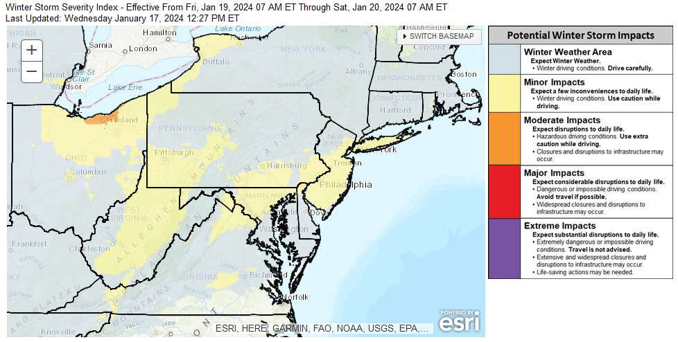
Although the specific amounts differ on the various models and exact details are not yet available with high confidence e.g., whether an inverted trough will develop and its placement, the overall theme is that this should be a relatively light event (1"-3"/2"-4"-type snowfall) for New York City, Newark, Philadelphia, and nearby areas. Ratios should be decent (12:1 to 15:1 generally), so if 0.15"-0.20" of precipitation falls, the region would generally see around 2"-3" of snow (at 15:1). Most of the 12z guidance is in that general ballpark with the NAM being a high outlier (for NYC). If one adjusts for the output that is based on 10:1 ratios, one would see the following from the 12z guidance for NYC (12:1 to 15:1 ratios): ECMWF: 1.0"-1.4" (low outlier) GFS: 1.7"-2.1" GGEM: 2.5"-3.2" ICON: 1.6"-2.0" NAM: 3.5"-4.4" (high outlier) RGEM: 2.2"-2.7" UKMET: 1.7"-2.1" Mean: 2.3" Standard Deviation: 0.9" The 1/17/2024 17z NBE shows 3.2" (on 0.16" precipitation or 20:1 ratio). That ratio is at the high-end of what typically occurs given the forecast temperatures. Even then, that solution would fall within the general kind of storm over which there is good model consensus. The WPC currently snows a minor event on its Day 3 map:
-
2.4" of snow fell at East Hills.
-
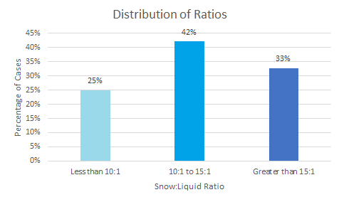
A quick note on ratios: Unlike with the January 6-7 storm that had above freezing temperatures throughout the duration of the storm in the New York City area and saw very low snow-to-liquid ratios, this storm will have above climatological ratios in the New York City area. From this far out, the soundings can still miss details necessary to really pin down the ratios. Nevertheless, looking at historic cases with a high temperature of 28°-32° and precipitation amounts of 0.05"-0.25" for the January 15-February 15 period in New York City's climate record, one can have confidence in higher ratios. There were 64 such cases since 1869. The mean snow-to-liquid ratio was 13.3:1. The median snow-to-liquid ratio was 12.5:1. Given the historic data and early soundings, my starting assumption is that the snow-to-liquid ratio for the upcoming storm will fall somewhere between 12:1 and 15:1. So, at this point my thinking is that this system will bring a general 1"-3"/2"-4"-type snowfall to New York City and Newark. As most of this snow will fall during the daytime on Friday, the record streak without 2" daily snowfall is likely to end.
-
Central Park had 0.16" of freezing rain. The highest freezing rain amounts in the New York NWS area were: East Hills, NY: 0.27" New Haven: 0.25" Bridgeport: 0.23" Harrison, NJ: 0.20" Darien: 0.18" 1 N Meriden Airport, CT: 0.18" New York City (Central Park): 0.16" 1 W Plainview, NY: 0.13"
-
In this case, probably not. The differences were sufficiently small that they could be within the variation one would see with the QPF. Moreover, Central Park reported an observation after 7 am with an increase in snowfall suggesting that a measurement was made when the snow stopped falling.
-
It peaked on a multiweek basis. December may also have been the monthly peak. We'll see when the final ENSO numbers are available.
-
LaGuardia's final snowfall was 2.3".
-
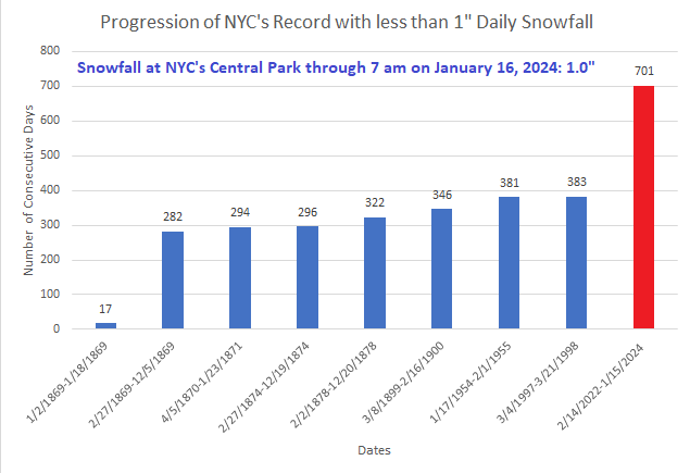
New York City's record 701-day streak without 1" daily snowfall ended today. Its record 717-day streak without 2" or more daily snowfall continued. A fresh shot of cold air will overspread the region following the storm responsible for New York City's and Philadelphia's biggest snowfall so far this winter. The low temperature could fall into the teens for the first time this season. Another storm could impact the region Friday or Saturday. However, uncertainty about the storm's track and impact has increased. The low temperature could fall into the teens in New York City during the weekend, which will likely see this winter's coldest readings so far. Beyond that, a noticeable warming trend that could send temperatures well into the 40s across the region and even into the 50s in parts of the region will likely commence. This warm period will very likely assure that January will wind up as a warmer than normal month and Winter 2023-24 will become yet another warmer than normal winter in the New York City and Philadelphia areas. The ENSO Region 1+2 anomaly was +0.9°C and the Region 3.4 anomaly was +1.9°C for the week centered around January 10. For the past six weeks, the ENSO Region 1+2 anomaly has averaged +1.18°C and the ENSO Region 3.4 anomaly has averaged +1.95°C. A basinwide El Niño event is ongoing. The ongoing El Niño event has recently peaked. The SOI was +31.61 today. The preliminary Arctic Oscillation (AO) was -2.670 today. Strong blocking in the final week of November, as occurred this year, has often been followed by frequent blocking in December and January. On January 14 the MJO was in Phase 4 at an amplitude of 1.828 (RMM). The January 13-adjusted amplitude was 1.515 (RMM). Based on sensitivity analysis applied to the latest guidance, there is an implied 76% probability that New York City will have a warmer than normal January (1991-2020 normal). January will likely finish with a mean temperature near 35.3° (1.6° above normal).
-
Midwest Regional Climate Center has hourly data.
-
That's currently the latest report.
-
Providence traffic cameras for those who are interested: https://www.dot.ri.gov/travel/cameras_metro.php
-
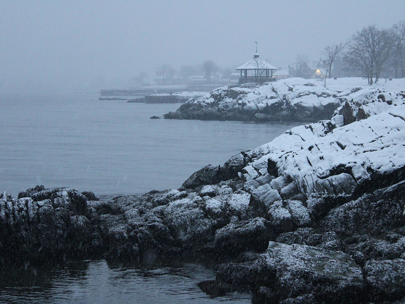
Quite a few locations on the Island picked up 2"-3" of snow. That was probably a nice positive surprise. Hopefully, the rain will end as snow.
-
That's actually 716 days. It will likely reach 717 days today, as I doubt we'll reach 2" daily snowfall today. It will be a close call, though.
-
New York City (Central Park) has received 1.4" of snow through 7 am, including 1.0" today. That ends the City's record 701-day stretch without an inch of daily snowfall.
-
January 15-16 winter storm OBS
donsutherland1 replied to Hurricane Agnes's topic in Philadelphia Region
Philadelphia's record 715-day streak with less than 1" daily snowfall has ended.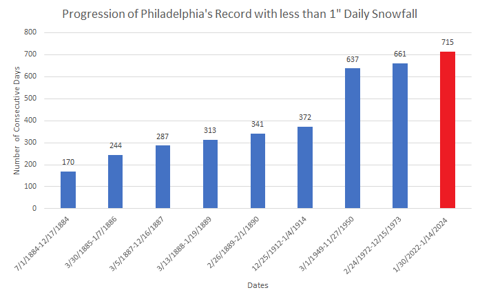
-
Philadelphia and New York City will see their streaks end. It will be close in Atlantic City, which would set a new record of 716 days if it fails to measure 1" today.